From the press release:
AirMap and American Association of Airport Executives Launch UAS Notice System
by • 30 March 2016

From the press release:
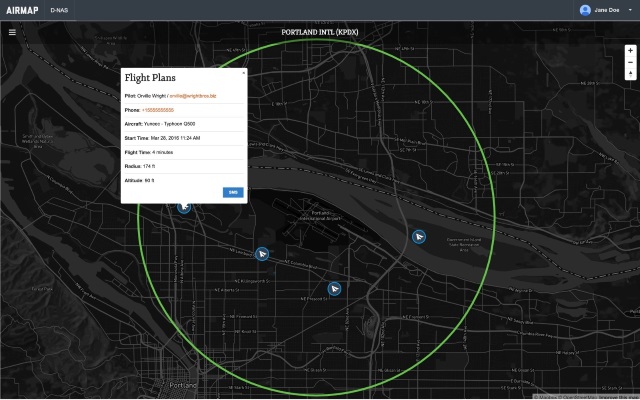
AirMap, a provider of airspace information and services for unmanned aircraft, and the American Association of Airport Executives (AAAE), through the Airport Innovation Accelerator, have announced the release of the Digital Notice and Awareness System (D-NAS). D-NAS was created to allow UAS operators to provide airports with real-time digital information about the location of their flights.
D-NAS works by allowing a UAS operator to send an encrypted digital flight notice to a secure dashboard at an airport’s operations center. Flight information will be able to be submitted through many different UAS interfaces, including the flying apps provided by leading drone manufacturers DJI, Yuneec, and 3DRobotics. These connections facilitate the transmission of important safety-critical information to airports, including the GPS location of the UAS flight. Participating airports will access this information through the AirMap D-NAS dashboard, which provides a map view of flights in proximity to the airport and the option to contact the UAS operator directly.
“Safety has always been a priority for DJI,” said Brendan Schulman, DJI’s Vice President of Policy and Legal Affairs. “Providing our customers the capability to easily notify nearby airports of their flights is a huge step forward in convenience and functionality. A high-tech notification system complements the safety features DJI builds into every drone, as well as DJI’s close work with policymakers on practical approaches for drone technology.”
Yuneec CEO Tian Yu explained, “We are excited to work with AirMap to improve the safety features of our products. As an airplane and helicopter pilot myself, I know first-hand how important it is to keep the national airspace system safe.” Yuneec is the manufacturer of the popular Typhoon and Tornado series of multirotor drones and recently announced a $60M investment from Intel.
More than 50 airports across America have already joined the D-NAS pilot program, including Houston’s George Bush Intercontinental and William P. Hobby airports, Denver International Airport, Columbus Air Force Base in Mississippi, Charlotte-Douglas Airport in North Carolina, Reno-Tahoe Airport in Nevada, New Castle Airport in Delaware, Cape May Airport in New Jersey, Fairbanks International Airport in Alaska, and the Oxnard and Camarillo Airports in Ventura County, California.
“Participation in the D-NAS pilot was a no-brainer for us. In the face of growing concerns over UAS operations near airports, AirMap has developed an effective and unique solution,” said Steve Runge, Division Manager for the Houston Airport System. “D-NAS is a game changer for how we will manage low altitude air safety.”
D-NAS not only provides heightened awareness to airports; it also makes it easy for UAS operators to comply with Section 336 of the FAA Modernization and Reform Act of 2012, which requires notice to be given to airports within five miles of a drone’s flight location.
Ben Marcus, CEO of AirMap and an airline transport rated pilot and flight instructor, said, “Everyone involved in aviation sees the promise and potential of unmanned aircraft. However, we can’t reach the potential of this amazing technology unless we ensure that safety critical information keeps pace with innovation. We are focused on building the tools for unmanned aircraft to safely integrate into the national airspace system.”
Comments
It good for drone safety. Aircraft in future is no longer threat to the drones. Unless dispatching service will be time forbid them to fly in the area where the drones work. =)
@Chris that would be UMBC. Next time you're in the area, you're welcome to visit our lab ASRL the autonomous systems research lab. It's a bit ironic, with the university's stance on UAS though.
@Stephen: What university is that? I just drove by BWI today on the way back from a visit at Johns Hopkins. Are you at the APL?
It would be nice, if we had a similar cloud based service here in Australia.
@David Drysdale - is that not what this is, just dressed up as something else?
http://diydrones.com/profiles/blogs/drone-registration-proposal-fro...
Very nice to se and a good step forward. I will be very interested to se if flight towers use it as the risk to airplanes from drones is so small as to be almost not statistically significant. But a much better solution than a drone registry.
Great work!
Too bad, I can't use this. My university is in class B near BWI, and by FAA rules I could use this to do my due diligence and notify the tower. But my university has banned all UAS flights under the mistaken assumption that they are not allowed in class B, and they refuse to review that policy when I present the FAA five mile notification rule.