MicroMappers combines crowdsourcing and artificial intelligence to make sense of “Big Data” for Social Good. Why artificial intelligence (AI)? Because regular crowdsourcing alone is no match for Big Data. The MicroMappers platform can already be used to crowdsource the search for relevant tweets as well as pictures, videos, text messages, aerial imagery and soon satellite imagery. The next step is therefore to add artificial intelligence to this crowdsourced filtering platform. We have already done this with tweets and SMS. So we’re now turning our attention to aerial and satellite imagery.
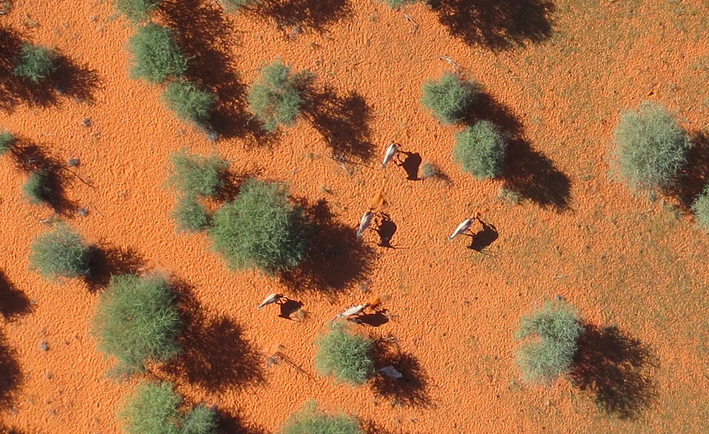
Our very first deployment of MicroMappers for aerial imagery analysis was in Africa for this wildlife protection project. We crowdsourced the search for wild animals in partnership with rangers from the Kuzikus Wildlife Reserve based in Namibia. We were very pleased with the results, and so were the rangers. As one of them noted: “I am impressed with the results. There are at times when the crowd found animals that I had missed!” We were also pleased that our effortscaught the attention of CNN. As noted in that CNN report, our plan for this pilot was to use crowdsourcing to find the wildlife and to then combine the results with artificial intelligence to develop a set of algorithms that can automatically find wild animals in the future.
To do this, we partnered with a wonderful team of graduate students at EPFL, the well known polytechnique in Lausanne, Switzerland. While these students were pressed for time due to a number of deadlines, they were nevertheless able to deliver some interesting results. Their applied, computer vision research is particularly useful given our ultimate aim: to create an algorithm that can learn to detect features of interest in aerial and satellite imagery in near real-time (as we’re interested in applying this to disaster response and other time-sensitive events). For now, however, we need to walk before we can run. This means carrying out the tasks of crowdsourcing and artificial intelligence in two (not-yet-integrated) steps.
As the EPFL students rightly note in their preliminary study, the use of thermal imaging (heat detection) to automatically identify wildlife in the bush is some-what problematic since “the temperature difference between animals and ground is much lower in savannah […].” This explains why the research team used the results of our crowdsourcing efforts instead. More specifically, they focused on automatically detecting the shadows of gazelles and ostriches by using an object based support vector machine (SVM). The whole process is summarized below.

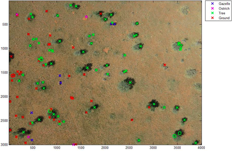
The above method produces results like the one below (click to enlarge). The circles represents the objects used to train the machine learning classifier. The discerning reader will note that the algorithm has correctly identified all the gazelles save for one instance in which two gazelles were standing close together were identified as one gazelle. But no other objects were mislabeled as a gazelle. In other words, EPFL’s gazelle algorithm is very accurate. “Hence the classifier could be used to reduce the number of objects to assess manually and make the search for gazelles faster.” Ostriches, on the other hand, proved more difficult to automatically detect. But the students are convinced that this could be improved if they had more time.
In conclusion, more work certainly needs to be done, but I am pleased by these preliminary and encouraging results. In addition, the students at EPFL kindly shared some concrete features that we can implement on the MicroMappers side to improve the crowdsourced results for the purposes of developing automated algorithms in the future. So a big thank you to Briant, Millet and Rey for taking the time to carry out the above research. My team and I at QCRI very much look forward to continuing our collaboration with them and colleagues at EPFL.

In the meantime, more on all this in my new book, Digital Humanitarians: How Big Data is Changing the Face of Humanitarian Response, which has alreadybeen endorsed by faculty at Harvard, MIT, Stanford, Oxford, etc; and by experts at the UN, World Bank, Red Cross, Twitter, etc.
Comments
I suppose we should close up this DIYDrones group then ; ) Many of the innovations pioneered by this community can obviously be used for ill. Besides, criminals / poachers have far more sophisticated technology available to them as evidenced by the increase in poaching worldwide. They hardly need our technology to make a difference.
Thanks,
Patrick (born & raised in Africa)
I know of one Rhino poached in broad daylight within 50m of a wedding that was happening. Electric chainsaw to cut off the horn, as Joe says vet drugs air rifle deployed. It is almost an impossible battle, the poachers have all the cards and a market to sell into. Joe is spot on the bad guys have more money than wildlife reserves. Rhinos are the poster boys for all this, many many other species are in far greater danger here in Africa. many folks are selling snake oil quick solutions and making claims that if you dig are utter rubbish. Money could have been spent in much better ways than the tech that arrives. Just improving the lives of people surrounding parks should be a start, if they see no benefit in the wildlife then why should they feel obliged to save it. Oh dear I feel I am beginning to ride the high horse! best stop.
This stuff does need to be worked on for disaster management, I get it. Really would not be possible to spot rhino in most of the country I fly, its dense dense vegetation.
An excellent concept, but, living in Africa, in fact in Namibia, and doing a lot of this type of work, we are constantly faced with the moral dilemma that these advancements in technology bring.
Poaching is rampant, and is driven by big money. In places the poaches use helicopters, with Vets (!) , to chase and shoot Rhino, land, de-horn, and leave. This sort of thing is not easily countered by less affluent nations , with small security forces and air support. And now, to begin placing this , basically open source; technology in the hands of criminals like this, frightens the hell out of me! The supreme essence of this would allow easy prediction of potential locations of the animals, and allow the poachers an easy in and out without spending much time in the area, thereby even more easily evading detection. There are no fancy long-range detection ground to air radar systems covering Africa...
What a dilemma...I wish these things die in the cradle. I wonder how we will be judged in some thousands of years when the then population studies our remains, relics and ruins. We studied the Dinosaur period, etc, found all the reasons ( maybe) for their extinction, the Inca's and all the rest, and in our ignorance made our judgments.. We probably will best be known for the rate at which we causes species to daily become extinct..Oh, and for Windows...
I wonder. Technology for the sake of it?
The Nampilot.