When Jeff Bezos appeared on 60 Minutes and showed the world the Amazon Prime Air drone delivery system, a lot of skeptics called it a publicity stunt and said such technology was a very long way off, if it ever materialized at all. It seemed like science fiction.
But when it became clear Bezos was serious, the first questions most people had were "what is going to stop a drone from crashing into me? Or my house? Or another drone?"
How could this science fiction technology ever work without killing us all?
To solve science fiction problems, we need science fiction solutions.
Dr. Parimal Kopardekar is literally a rocket scientist: he has worked on numerous Airspace and Air Transportation Technology projects at NASA, was the recipient of the NASA Ames Honor Award for Engineer of the Year in 2003 and he is currently the Principal Investigator of the NASA’s NextGen Airspace Project.
One of his current projects is the Unmanned Aerial Vehicle Traffic Management System (UTM), or what we mortals would call a "highway in the sky."
[caption id="attachment_5615" align="aligncenter" width="664"] This is not a drill[/caption]
As daunting as such a project sounds, Dr. Kopardekar's team is not starting from scratch. He explains:
The UTM construct is based on our research on the operator airspace; Class A,B,C and D. UTM is focused on Class G airspace because all of these operations will be in low altitudes. But the components of air space design - separation management, scheduling, demand capacity imbalance, contingency management [i.e. a 24-esqu hostile takeover], trajectory definition and prediction, wind and weather integration- that we have been working with for commercial carriers and upper airspace will be similar.We need to make adjustments, for example, to the trajectory definition and prediction because UAS will fly slower and at lower altitude, with different susceptibility to wind etc. We are going to use the lessons learned from the work we have been doing for nearly 20 years and adapt it to UTM.
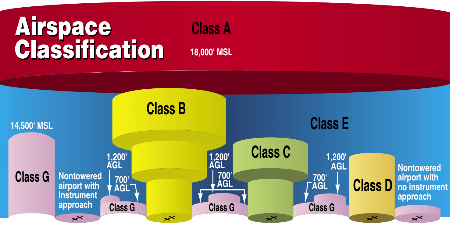 However, despite these lessons learned, Class G airspace (generally defined as under 1,200 feet above ground level) is roughly uncharted territory. Plus, human beings live in that airspace. As such, the aerial network will need to be incredibly precise.
So how do we safely accommodate these flying lawnmowers into the airspace above playgrounds and hospitals? By tapping into the so-called internet of things.
In order to accommodate low executed airspace operations we need a system. Right now there is no system. You can imagine how that could be chaos when everybody just starts to fly in the airspace.It's just like cars and roads; someone has to make sure that the cars have safety standards, that they won't stop or turn in the middle of the road on their own. Once you do that, you say "how do I accommodate all the industries and folks who will be driving the cars? You need roads, stop signs; you need lanes -one lane that goes one way and another lane that is coming back the other way. And that's what we are after.
We are basically creating this UAS traffic management system that allows you to accommodate the number of vehicles that will operate in the low altitude airspace. The analogy is 'just because we have a car, whether it's an autonomous car or someone is driving, does not negate the need for a road or stop signs or rules of the road.' The same thing happens in the airspace. We need to have a structure.
This is where Dr. Kopardekar's UTM base comes in. The UTM system allows UAS operators to create a geo-fenced area (an area defined by GPS coordinates) to pilot their aircraft. By staying in the geo-fenced area, all movements and behaviors of the vehicle can be monitored and operators can program flights based on GPS location.
Here's the fun part though: when you throw another UAS into the area (and/or a virtual skyscraper or playground full of children) the UAS then knows where everything is and operators can specify how close the drones are allowed to get to various obstacles or locations. Plus, because the trajectory of both aircraft are part of the "world's first cloud-based aerial architecture" that is UTM, they both know where the other is and will be, even if a gust of wind were to interfere.
Continue reading at dronelife.com...
Comments
I have read about these plans and ideas in my father's collestion magasines from 60s and in my magasines during my childhood in 80s and sometimes in the present. The conclusion? People wants it, people will do it. Keep working, this task will take lot of time time, but the result will be fantastic as much as described in 60s!
Well, who will issue the driving licence? :-)
I'm happy to see people are actually thinking about and working on it as it will be very important for further development of UAS.