We were excited by Pix4D’s Chillon project (http://pix4d.com/chillon/) and decided to make our own 3D reconstruction attempt using our U[g]CS software, DJI Phantom + GoPro and, of course, Pix4Dmapper.
Now we want to share how we made 3D reconstruction of our office.
Pix4D has recommendations for different type of targets. For buildings they recommend to execute two flights around the building with different altitudes and camera angles:
(The image is taken from the Pix4D site)
For a small building it’s possible to take all shots in a single flight, but in most ground station software it’s hard to plan missions where two or more waypoints are located in the same position, but at different altitudes.
Using U[g]CS we can easily create such waypoints thanks to true 3D environment:
So we planned a single mission around our office with two rounds around the building. DJI Phantom 2 autopilot is limited to 16 waypoints, but in this case it wasn’t a problem because we set GoPro to take one shot every half a second.
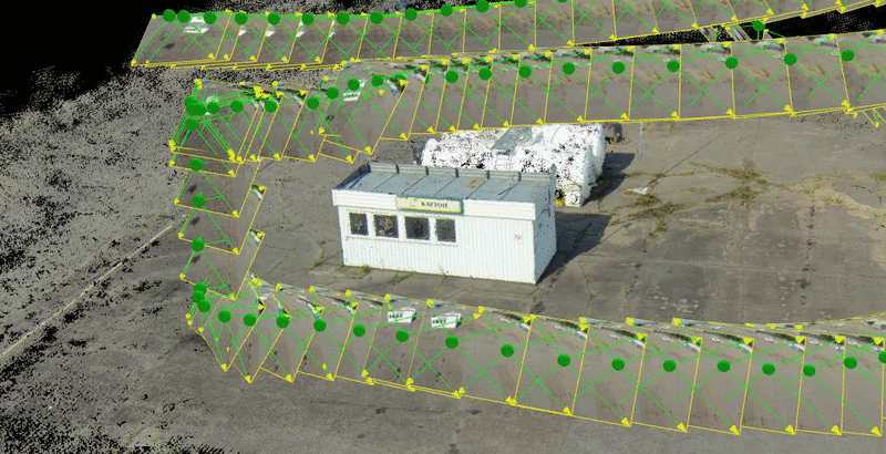
This is how the mission for our Phantom looks like:
After a very short flight we have got 395 pictures. They were loaded into Pix4D projected and processed by point cloud building algorithm.
First of all, we were impressed by how precisely Pix4D has restored drone trajectory (first picture in this post). More accurately in comparison with GPS track.
And here is the result of point cloud visualization of our office made in Pix4D:
We have also 3D reconstructed another object close to our office — fuel tank station at the airfield:
3D point cloud animation is available for download here.
Taking into account fully automated processing workflow and our zero experience in 3D reconstructions, we think that achieved results are quite good. Next time we will try to get more accurate results by combining different drone trajectories, ground control points and processing modes in Pix4D.
Sincerely, U[g]CS team