Just a few years back, drone photography was a dream of many, but only a few were able to fulfill their interests in it. However, with its steaming popularity over the years, drone photography has become an integral part of marketing practice in top-notch business firms. Initially developed solely for military purposes, drones have come to become the passion and interest of many in the present times.
Instead of just remaining a part of one’s hobby or passion, drone photography has come to establish a prominent place in the professional world as well. Drone photography is used to develop aerial images with the accuracy and precision of a bird’s eye view. However, if you are planning to hire drone photographer, there are a few things that you will need to check and confirm beforehand. This article will familiarize you with certain most effective tips and tricks to spot the most “professional drone photographer near me”.
6 Ways to Spot the “Best Drone Photographer Near Me”
Choosing a professional who can meet all your demands can get a little tricky, but with the following tricks, you will be able to select the one that provides the best and most effective results.
Ensure the Drone Photographer is Licensed
If you wish to hire drone photographer who is professional, it is important that you ensure that the person is insured and licensed. You can ensure this by checking whether the person in question is the recipient of the FAA Airman Certificate. The acquisition of this certificate ensures the professional’s knowledge and stronghold of operating a UAV commercially.
In addition, as mentioned earlier, it is also vital to check if the professional is insured or not. Professional drone photographers always make sure to prove their capability by rightfully producing liability insurance. This insurance is crucial for the safety of both the professional and their clients.
Gather Information About their Photography Skills
To derive the best outcomes, it is important that you choose a professional who is confident and well-aware of their flight knowledge. A renowned professional in the field will be able to easily change their camera settings to adjust the light, control the drone’s speed, and focus on the subject at hand with precision.
Apart from this, make sure to gather precise knowledge of the photo or video quality that their drone can produce.
The best way to test someone’s knowledge of drones is to ask them questions surrounding the subject. Their confidence or under-confidence is the best answer to the question “best aerial photographer near me.”
Choose a Professional Capable of Fulfilling your Narrative and Needs
Aerial photography is relatively easier when there is only one subject in question. However, in situations where one requires intimate and accurate shots of corporate or family gatherings, the task gets a lot more intense. As the client, it is your responsibility to communicate and discuss your expectations with the drone photographer and production team before finalizing their services. Make sure to let them know the exact details of the kind of pictures, locations, angles, etc, you want the photographer to capture. Choose the one that promises to provide the results you aspire to.
Learn About the Equipment the Photographer Will Use
In addition to choosing the best drone photographer, you will also have to inquire about the types of equipment they will use to complete your project. However, keep in mind that a professional with the most expensive equipment does not necessarily promise the best results. It is heavily dependent on the knowledge and skills of the professional. Although good equipment is definitely a plus, the primary importance should always be placed on the practical skills of the drone photographer.
Ask for Sample Works
To get a definite idea of the professional’s skills and expertise, you should demand their previous samples and works. Keep in mind that photography and videography are two extreme and different things, and each requires a different set of skills and expertise. Therefore, while going through their previous work samples, make sure that the photographer is able to win your confidence in both drone photographer and videographer.
Along with this, post editing and trimming is also a critical part of Video Editing Services. So put a stamp on the photographer who has sharp skills in not just photography or videography, but also the editing that follows.
Discuss and Finalize the Budget
The last step in choosing the “best drone photographer near me” is settling down on a budget that goes well with both parties. As stated in the previous point, drone photography or videography is a two-stage work, that is, the production and the post-production.
Therefore, make sure to sit, discuss and settle for a budget that sits well with you as well as the photographer. Ensure that the photographer is compensated well for their hard work, while also maintaining that the budget is not very heavy on your pocket as well.
Conclusion
Drone photography is definitely the most modern and advanced photography in modern times. With countless enthusiasts posing as drone photography professionals, it often gets difficult to sieve out the “ best aerial photographer near me”. However, following the above-mentioned tips will make the task easier and more fruitful.
One such answer to the question “best drone photographer Park city area” is definitely Alex and his highly professional team. Alex Drone Photography offers high-quality aerial drone photography services and full-scale video production marketing services.
The new agricultural drone assembly solution ——Z series, adopt humanized structure design.Fully optimized customer operating experience,easier and more convenient. Equip with arm handle buckle and the smart sensor can real-time monitor the arm status, effectively prevent the crash caused by the loose arm . Also the double inlets,smoother pouring. And Z-type folding structure makes it smaller and easier to transport.
Posted by Vivek Dwivedi on January 10, 2023 at 6:23am
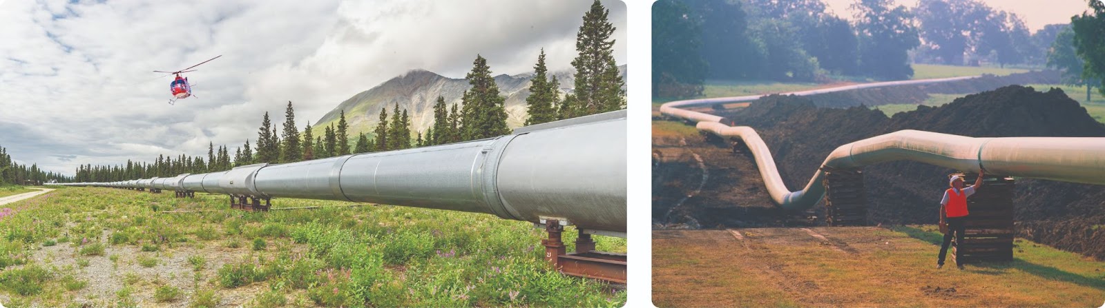
As the world's primary fuel sources, oil and natural gas are major industries in the energy industry and have a significant impact on the global economy. Demand for petroleum and petroleum products has only increased in the recent past due to global economic and population growth, as well as continual urbanization and industrialization.
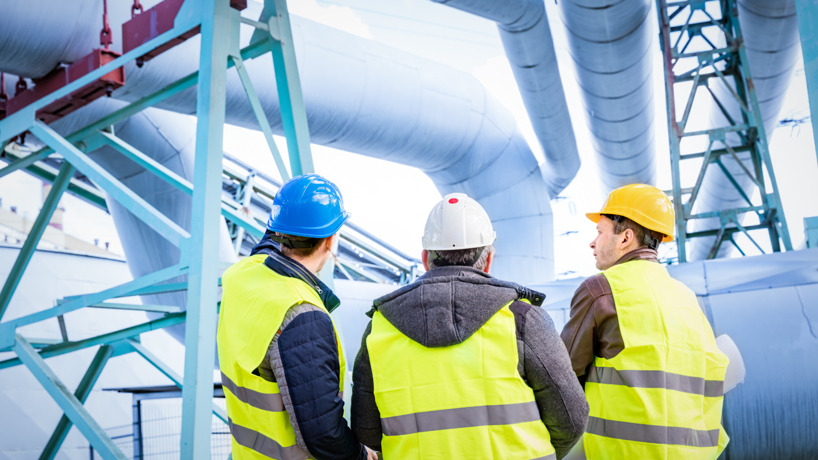
Pipelines are vital infrastructure for the transmission of oil and natural gas, connecting producing areas to refineries, chemical plants, home customers, and commercial demands. However, oil and natural gas are combustible and explosive substances that are typically delivered via high-temperature, high-pressure pipeline networks. Hereby, it is critical to monitor these pipelines to ensure that they are operating effectively.
However, traditional pipeline inspection methods have some issues, such as:
Use of crewed aircraft
Currently, the majority of energy companies use helicopters to monitor encroachment in potential pipeline Right-Of-Ways (ROW). Each expedition costs an average of $150,000, making more regular inspections than every six months almost impractical.
Foot Patrols
Once the aircraft confirms an encroachment, foot patrols, typically consisting of two personnel, are dispatched to these remote locations. Such manual site inspections take approximately 8 hours and cost approximately $500 merely to have a closer look and validate the threat.
conducting pipeline monitoring for oil and gas companies with manual methods
Inability to send crew at all times
Pipelines can be hundreds of kilometers long and can be spread over vast remote locations. Sending operators to such locations can put human life at risk. Hereby, it becomes quite difficult to send inspection teams to cover such areas at all times.
Time-consuming method
Traveling from one asset to another is frequently difficult. Operators may need to drive lengthy miles along gravel or dirt roads to visit several inspection sites. The distance and hard terrain may need a significant amount of time.
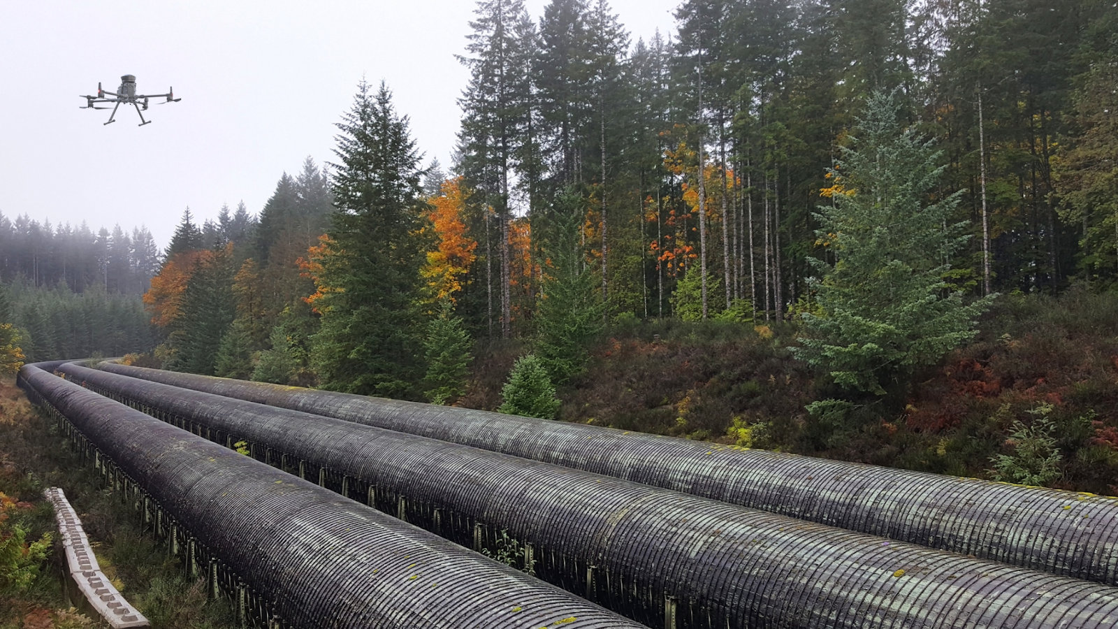
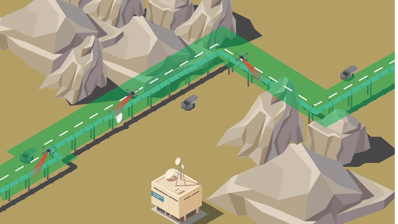
How can Drones with BVLOS Capabilities Help Oil and Gas Companies Secure Pipelines
Ease of travel between assets
Drone program can help in conducting inspection for oil and gas companies without human intervention
Traveling between assets during inspection operations might become challenging because these pipes can span thousands of meters. The team may be required to travel long distances and to distant regions where there is no adequate road infrastructure.
Operators must travel to the sites, assess the asset, review their data, and then drive to another asset. Furthermore, they must repeat the entire process until all assets have been inspected. This can take a significant amount of time which can be costly for an industry like oil and gas.
However, drones can travel vast distances and reach difficult-to-access locations. Additionally, using drone-in-a-box systems, eliminate the need for continual re-launching, packing, and landing of drones which is majorly faced in manual-led VLOS operations.
Increase worker safety
Oftentimes, assets are located on high terrains or difficult-to-reach locations. Operators may need to set up substantial scaffolding or dangle from ropes to inspect this equipment. Any mistake here can result in severe consequences. Despite the industry's strict regulations and safety standards, health and safety concerns persist. A BVLOS operation eliminates the operator's danger by allowing them to undertake the flight mission from any remote location.
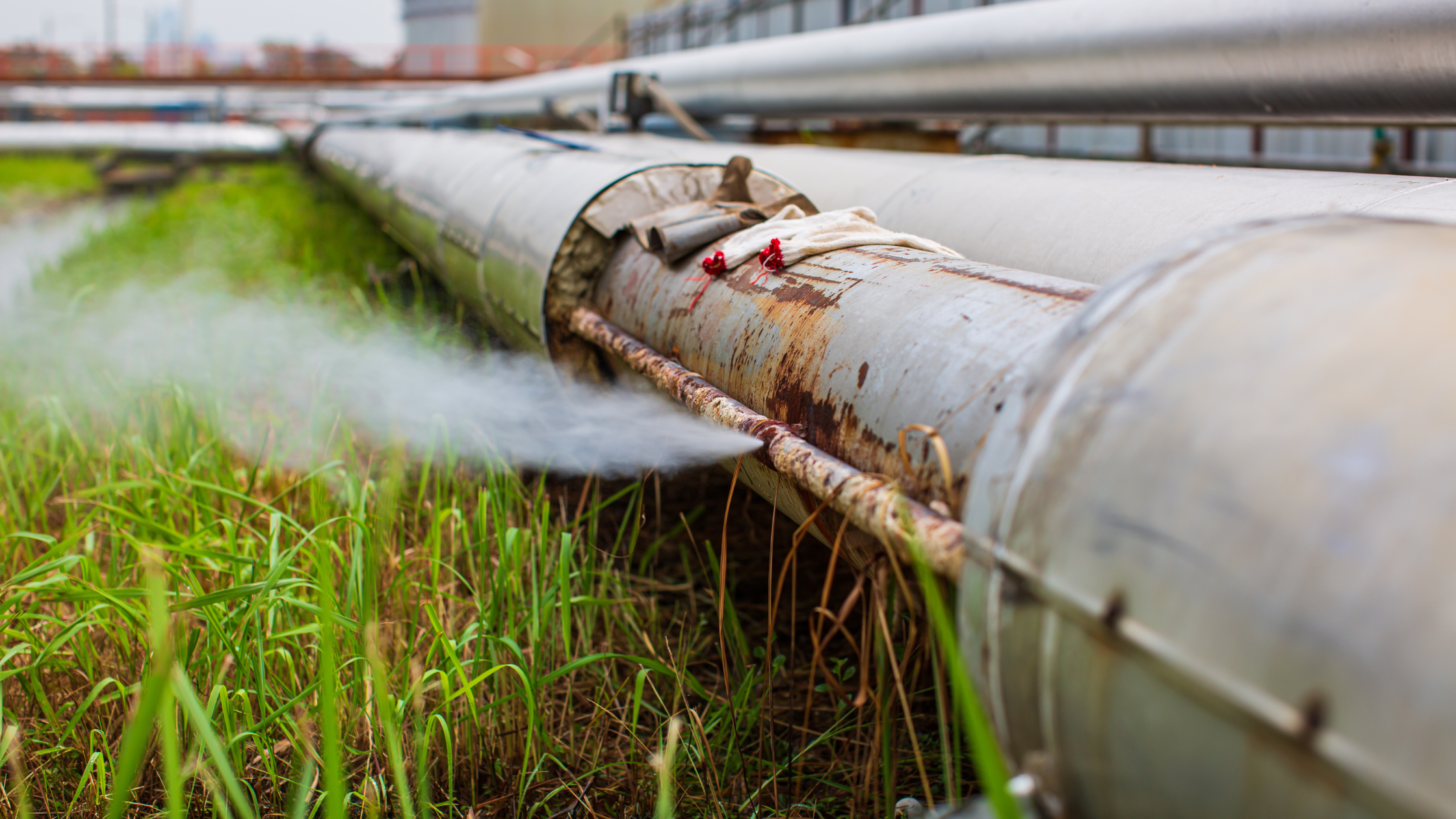
Simplify early detection of pipeline leaks
Example of leak in the gas pipeline is affecting the surrounding environment
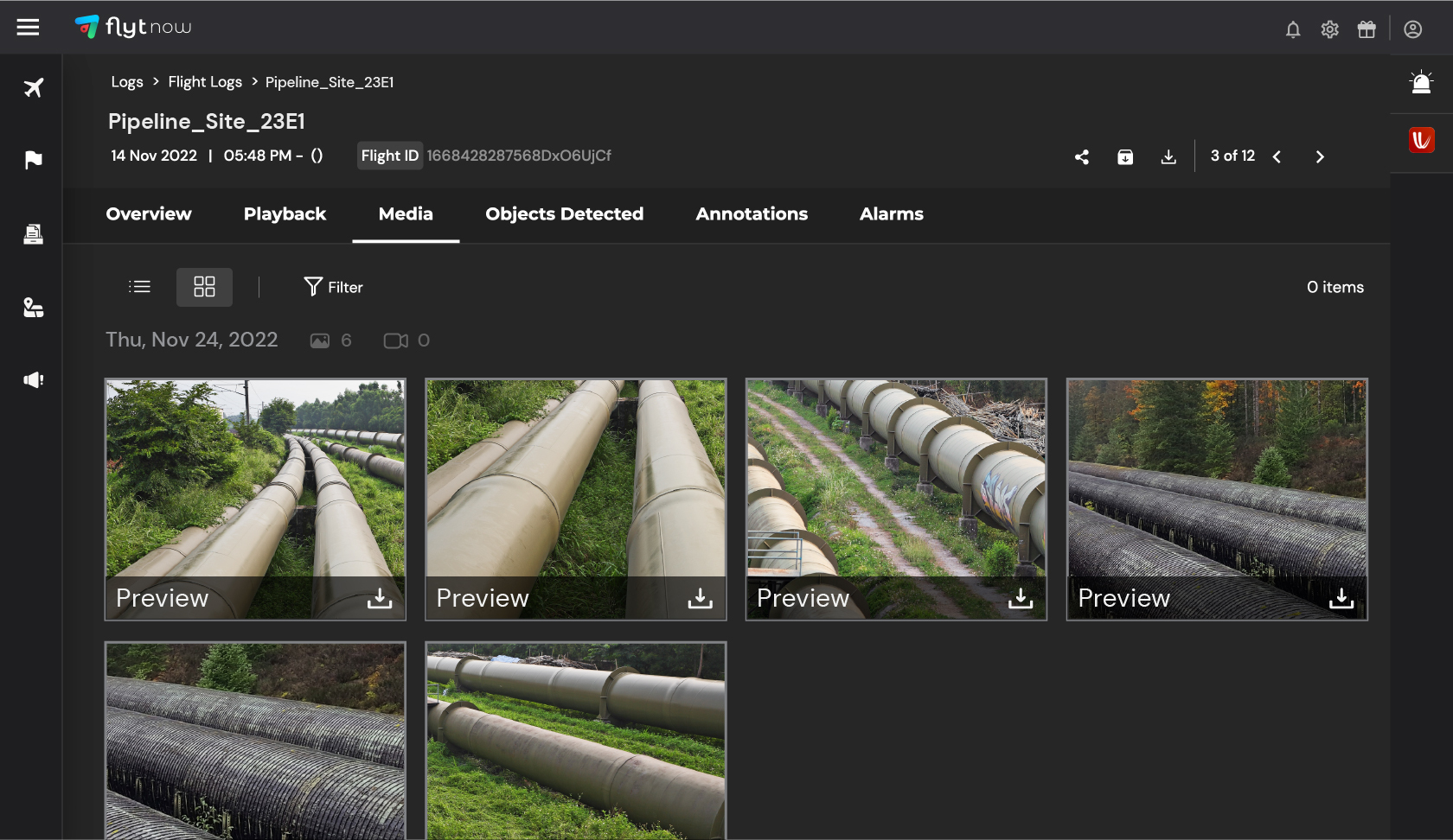
These drones can easily access hard-to-reach areas and capture high-quality photos and videos of the pipelines and storage tanks. These data can be helpful to conduct image analytics for accurate and early detection of potential leaks or damage.
This allows operators to respond quickly and effectively to potential pipeline failure, minimizing the impact on the environment and reducing the risk of accidents. The use of drones also reduces the potential for human error, as operators can monitor the pipelines remotely, without the need for physical inspections.
Reduce heavy costs
Hiring a pilot and a helicopter, for example, can cost thousands of dollars. Regular inspections may become prohibitively expensive and time-consuming. Autonomous drone missions can minimize such costs while also minimizing human dependency.
Utilize readymade data and analytics via automated procedures
A human-led operation requires the operator to drive to the location and visually inspect the asset. Via autonomous operations, drone operators can run pre-planned drone flights and augment the inspection process. The drone will follow its routine, capture and store data which can be further assessed for detailed inspection as per need.
This enables the operator to quantify their assessment with turnkey data and analytics delivered via automated workflows. This simplifies the entire process and backs it up with data, which greatly aids decision-making.
Ability to scale operations
While examining pipelines spanning thousands of kilometers, it becomes nearly impossible to conduct manual operations consistently. However, autonomous drones can be scaled up and deployed readily to fit the business's needs as they can be programmed to conduct the desired tasks.
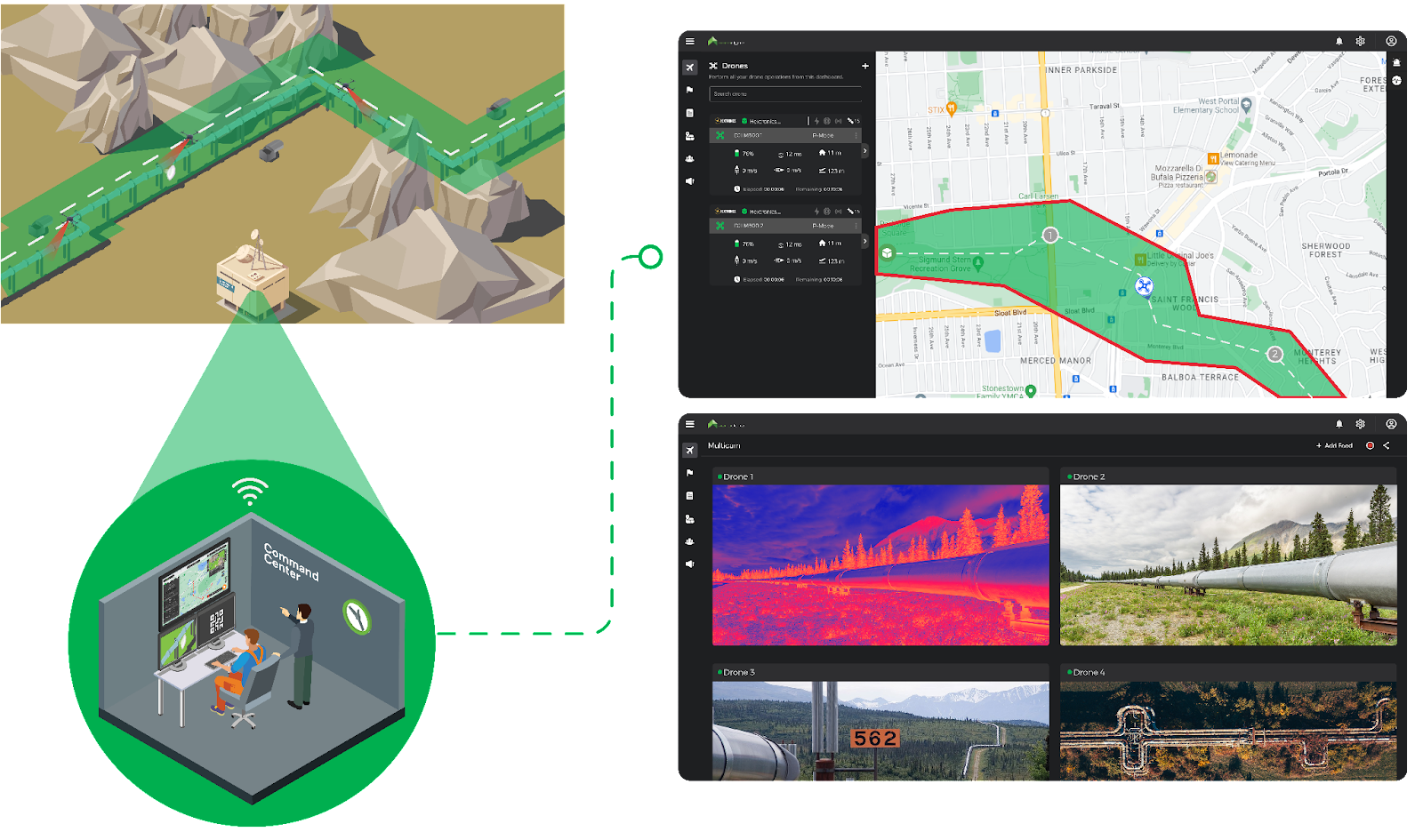
How FlytNow is Enabling BVLOS Operations
BVLOS operations in pipeline inspection
FlytNow is a cloud-based solution that enables the deployment and management of drones in just a few clicks, allowing you to manage your drone operations via a single web-based dashboard for a seamless experience. It helps you lower travel costs, reduce operation rounds, and increase productivity by saving travel time. It is integrated with ready-to-use intelligent modules, like collision avoidance, and precision landing, and integration with drone-in-a-box systems, which further helps you shorten your time to market.
The FlytNow software solution enables project managers to schedule pre-planned or on-demand flights from a command center located miles away from the base station. The drone takes off from the drone nest autonomously, flies its mission, captures real-time videos and images, and uploads them to the cloud.
Store images and videos on cloud and Identify leaks on pipelines with FlytNow's solution
Following the flight, the drone returns to the docking station for battery swapping and storage. These stations can charge up to four batteries simultaneously and swap out the existing battery in less than 90 seconds, ensuring minimal downtime. Furthermore, because it is lightweight, it can easily fit on the back of a pickup truck and be moved from one location to another if necessary.
3rd party integrations in FlytNow, such as Casia G system by Iris Automation for detection and avoidance of cooperative and non-cooperative aircraft, Altitude Angel for airspace awareness, and others, assist to increase capabilities for greater insights and seamless BVLOS operations.
Leveraging Nested Drone Systems (NDS)
How nested drone system helping in pipeline inspection
The Nested Drone Systems (NDS) can significantly improve the data collection process and transform how pipelines are inspected. It lets the drone operator conduct long-duration flights without the need to return the drone to the command center to recharge or swap the battery. With the nested drone system, energy companies would be able to quickly scale up, undergo a digital transformation, run safely, and boost productivity.
Nitin Gupta, Founder & CEO of FlytBase, Inc. concludes by stating that “Nested Drone Solutions are rapidly revolutionizing the way repeatable, high-frequency missions are conducted across use-cases. Maintenance of pipelines, spread over thousands of miles, is a great application of this technology with a significant ROI for the end-user.
FAQs
1) How can drones improve the safety of inspections on oil and gas pipelines?
Drones can play a vital role in improving the safety of inspections in the oil and gas industry. With their ability to fly closer to the ground, drones can provide high-resolution aerial data through the use of visual or infrared cameras. This allows for more precise and thorough inspections of pipelines, particularly in hard-to-reach areas.
By using drones, workers can avoid the potential dangers of inspecting pipelines on foot, such as exposure to crude oil leaks. Additionally, the use of drones allows for earlier detection of leaks, which can prevent potential disasters and safeguard the environment.
2) What are the benefits of using drones for pipeline inspections?
Drones provide several benefits for pipeline inspections, including accuracy and improved technologies. Using drones to detect leaks and identify potential issues can save costs and equipment compared to traditional inspection methods. Drones can also access dangerous terrain and provide quick emergency response.
In addition, using drones for regular inspection can improve worker safety by avoiding the need for workers to enter hazardous areas. Visual or infrared cameras on drones can monitor pipelines and identify potential issues, whether it be for gas or oil pipelines. With better data and improved maintenance, major accidents can be avoided through the use of drones for pipeline inspections.
3) How can FlytNow help in pipeline inspection using drone-in-a-box systems?
Using FlytNow-powered drones for pipeline inspection, operators can now easily detect any leaks in the pipeline with greater accuracy and efficiency than traditional methods. It allows the team to access difficult-to-reach areas and avoid putting any human in potential danger.
Furthermore, operators can get a real-time video stream of the assets, and also capture high-quality photos and videos of the pipelines and storage tanks. This significantly helps in conducting accurate inspections and detecting potential leaks or damage.
4) What can we expect in upcoming technologies in oil and gas pipeline inspection?
New technologies will include autonomous drones that are packed with a cost-effective platform that will help in inspecting pipelines, provide insight for maintenance activities, and identify human errors. Moreover, they will be equipped with a visual or infrared camera that can detect leaks or damage on its own and inform the team immediately.
5) What are some of the best drones for pipeline inspections in the oil and gas industry?
There are several drones that are well-suited for use in pipeline inspections in the oil and gas industry. Some options include:
DJI Phantom 4 RTK: This drone has a high-resolution camera and RTK GPS for precise mapping and surveying capabilities.
DJI Mavic 2 Enterprise Dual: This drone has a compact design and can fly in challenging weather conditions. It also has a dual thermal and visible light camera for identifying issues in pipelines.
senseFly eBee X: This drone has a long flight time and can fly in autonomous missions to cover large areas quickly. It also has a high-resolution camera for detailed inspection.
Parrot Anafi USA: This drone has a 4K HDR camera and is capable of flying in challenging environments. It is also lightweight and easy to transport.
Have you been troubled by many scattered modules and messy wiring in the aircraft cabin?
Have you noticed that inside the conventional assembled drone, the wiring is very complicated,easily wrong connection and difficult troubleshooting? And the scattered modules often encounter incompatibility, cause some functions are unavailable and lower the performance of the whole drone.
As a senior participant in the UAV assembly industry—EFT Company, just launched Z-series integrated module flight control which can effectively solves the above problems.
Below is the video of product assess for your reference.
Summary of the features : Integrated modular design, RTK, flight control and receiver can be plug and play, free debugging. Easy to operate and better waterproof Neat layout and simplified maintenance Customized firmware and protocol for smoothly interconnected of whole drone, greatly upgrade intelligent effect .
If you have new requirements or ideas for assembling agricultural drones, welcome to contact us.
Proposed and documented during a ideation session in 2010 it is great to see this come to fruition even if it is from sone other group. No matter who develops the innovation everyone can now benefit. Well done!
Read more…
The cost of assembly drones is relatively low, gradually getting popular with ordinary farmers and plant protection service teams.
However, there are some disadvantages of assembly drones, such as low intellegence, complex debugging, messy wiring etc.,which are bother most assembler dealers and service providers.
For above cases, EFT developed the Z series holistic smart drone system solution . Z series drone solution innovatived in structure,and configured with intelligent linkage system , deep integration of software and hardware, professional comprehensive inspection to ensure the quality . Realized more convenient , more intelligent and precise , more stable and durable.
If you are interested ,welcome to contact us to learn more .
𝗜𝗻𝘁𝗿𝗼𝗱𝘂𝗰𝗶𝗻𝗴 𝗭𝗜𝗢 | 𝗠𝗲𝗲𝘁 𝗧𝗵𝗲 𝗙𝗶𝗿𝘀𝘁 𝗣𝗮𝘆𝗹𝗼𝗮𝗱 𝗼𝗳 𝗚𝗿𝗲𝗺𝘀𝘆 Over a decade known as a gimbal manufacturer. Today, Gremsy introduces a new product; the initial payload is called Zio. The launch of a brand-new line of Gremsy ecosystem. Zio is a high-resolution zoom payload that combines a Sony sensor with high-stabilized three-axis gimbal technology. It enables industrial inspectors and surveyors to zoom into objects of interest and effortlessly transmit video at 4K resolution, ready to be utilized for a variety of different inspection, surveying, and public safety jobs.
The ultimate solution for remote sensing and IoT monitoring applications, this module can be easily used on unmanned systems for research, meteorological applications, wildfire monitoring systems, and security applications.
This Plug and Play module directly connects to the TELEM1/2 port of your Pixhawk system to provide satellite telemetry, easy to set up, and to use with QGC or other ground station software.
This system integrates an Iridium 9603 module to transmit telemetry information wherever on the planet.
The Grasshopper NDVI is the newest in our line of simple-to-use survey cameras. Every Grasshopper NDVI camera allows the connection to an external USB GPS receiver to automatically geo-tag each captured image. Its 8MP sensor and sharp non-fisheye lens allow you to capture aerial media easily. It captures photos on the default timer trigger or can be sent a PWM signal through the HDMI port (see below). If you supply power to the USB port it will power on the camera automatically. Sized similar to a GoPro® Hero these small survey cameras can be attached to your aerial drone platform using our various mounts.
This Red+NIR (NDVI) model sees Near Infrared 850nm and Red 660nm light. The images from this camera are commonly calibrated into an index image and then a colored lut is applied to show contrast between healthy and poor health vegetation.
Drone spraying pesticides has become more and more popular, which is cheaper and more efficient than traditional manual spraying. However, But sowing and fertilizing, most small farmers still work in the traditional way.
One is a complete drone with spraying and spreading functions, such as DJI and XAG. Another is spraying drone, which can be upgraded to an all-round agricultural drone by a detachable spreader. For example, the V2.0 granule spreader is integrated structure and tool-free,easy for pilots to modify and adapt to all open source flight controllers. For pilots or agricultural service teams, the cost of investment and replacement is lower.It can sow rice, wheat, soybean, cotton, etc. evenly and efficiently at 360°, or fertilize.
With the development of technology, drones are becoming more powerful and easier to assemble and operate. This is conducive to the majority of farmers to easily farm, reduce costs and increase income.
Pixy WE is the gimbal tailored for Workswell Wiris Enterprise, making the flawless combination ready to be used for all unmanned vehicles. The gimbal comes with all advanced built-in functions to serve mapping, security, and high-resolution imagery applications.
Posted by drone036 on November 14, 2022 at 12:39am
Autel Robotics EVO II Pro 6K Drone Advanced Rugged Bundle contains drones and accessories in a military-grade hard case for easy transport and gives your gear ultimate protection. The precision-cut foam case stores and protects the EVO II Pro aircraft, 3 spare batteries, (total 4 flight batteries), controller, charging hub, spare props and charger.
Autel EVO 2 Pro ultra-HD video camera drone featured a 1-inch sensor with 6K video and 20MP photo. Capture stunning detail not previously possible on an aerial platform of this size. An adjustable aperture from f/2.8 - f/11, HDR and intuitive camera controls make this the perfect choice for any aerial cinematographer or mapping pilot.[Autel EVO II Pro V2 drone returns to home automatically without GPS signal at high altitude.]
1″ CMOS Sensor & F/2.8-F/11 Adjustable Aperture
6K Hyper-lapse photography and More Shooting Modes
Capture the night time world
10-bit A-Log Color Recording
Connect Autel Live Deck to display live video from EVO II on any device
Adjust field-of-view to any angle from 0° to 90° while flying
Posted by Tomi Piriyev on November 12, 2022 at 11:25pm
Hello Everyone, I have been working on loko for a quite time , which is the smallest GPS tracker with LoRa peer to peer communication . And now Lora is open forpre-orders on CrowdSUpply.
Loko is a tiny, easy-to-use, open-source, battery-operated, GPS tracker that sends navigation data to its receiver via peer-to-peer LoRa radio. Loko works through radio communication and does not require a SIM card or monthly fee. It also works anywhere, even if there is no 2G, 3G, or LTE coverage.
Excellent for Drones & More
Loko is an investment that allows drone owners to protect against the common occurrence of crashes and signal loss. But Loko is useful for more than just drone tracking. You can keep track of any device or belonging, which is important in a variety of personal and professional settings where you need to know a location in realtime.
As an effective measure to reduce agricultural production costs and solve labor shortage,UAV precision spreading and fertilization technology has been promoted by various countries.
Drones improve agricultural planting efficiency
Nowadays, "drone direct planting" technology has been vigorously promoted in South Korea as an alternative measure to cope with the shortage of rural labor. The South Korean government plans to invest 15 billion won by 2025 to expand the direct seeding area to 10% of the total rice planting area (13,000 hectares). Drone spreading can precise and quantitative sowing, which can help farmers effectively save 30% of seed per hectare. Efficient and precise operation reduce labor costs by 90% and operating costs by 85%.
Drones help the development of agricultural intelligence in Southeast Asia
Southeast Asian countries are increasingly shifting from traditional to modern agriculture. Currently, 2,000-3,000 agricultural drones are flying in the fields in Thailand, only cover 20% of the farmland area, 90% of the drones are used for spraying pesticides , and the drone spreading market is growing steadily.More and more agricultural drones are flying into farmland to help farmers increase production and income.
The intelligentization and dataization of agricultural machinery is a trend, and the low-cost and high-efficiency aerial work tools of drones will be adopted by more and more farms.
Headquartered in Oostkamp, Belgium, Citymesh is a pioneer of wireless connectivity with fifteen years of experience in high-end network design, installation, and maintenance. Through the combination of various technologies including 5G, Wi-Fi, smart sensors, and data visualization, they provide B2B smart infrastructure and innovative solutions in a variety of markets that are tailored to the needs of their clients.
They specialize in private 5G services and play a key role in setting up wireless networks in (smart) cities, at events, (air)ports, industrial facilities, and warehouses.
Why Genk is Using Smart Tech to Improve Emergency Response
Rapid response in the face of crises and life-threatening situations, such as fires and incidents, is critical for city officials all over the world. Fire departments across nations are implementing new technologies to improve operations and save lives.
Drones are one such valuable tool that has assisted firefighters in improving situational awareness. The imaging technology, software and accessories on board the drone enables the emergency services to gather information more quickly and efficiently in the event of an incident. Some of the major challenges that drones are able to solve include:
Incorrect Initial Report of Incident: The emergency services often receive distress calls, either from a bystander at the scene of the incident that does not fully or sometimes even incorrectly describes the incident or from an automated fire alarm. The emergency services dispatcher allocates resources based on the report, only to discover that they are insufficient in scale and/or type for the actual incident. Response time is critical. Any delay in responding to the incident effectively could result in fatalities or additional infrastructure damage. A local drone team needs time to drive to the scene, get the drone ready and start flying.
Lack of Real-time Awareness: Determining the extent of the fire, how to tackle it and the threat it poses can frequently be challenging due to the smoke and obstacles en-route to and onsite. The capacity of fire teams to respond to the situation quickly, adequately & efficiently is limited by these difficult-to-reach locations.
However, drones piloted by humans have certain limitations especially in fast-paced, dynamic environments.
Closing the Information Gap: Only the emergency services’ own drone team at the scene and, in best case, the local fire services officer are fully aware of the situation. Streaming the drone’s camera video feed to a local emergency services command center and/or dispatch or other stakeholders is not always possible, reliable or cheap. As a result, dispatchers and fire service officers coordinating from the department’s headquarters, especially in case of large scale incidents, frequently lack complete information, making it difficult to make the right decisions.
Inefficient Operations: It is challenging to respond with the appropriate level of resources, equipment & urgency if the team lacks clear knowledge. Sending too little resources can have detrimental consequences, but sending too much resources is problematic too as it draws the limited resources away from other incidents. In addition, heavy fire trucks racing through dense city centers poses its own risks for safety.
To overcome all these obstacles, the Belgian city of Genk decided to implement a combination of autonomous drone-in-a-box technology, AI, and a private 5G network to provide unique insights to emergency services without the need for additional staff.
Mayor Wim Dries emphasizes “Because of the dynamic nature of a city like Genk, we want to keep innovating. As a smart city, we use technology to improve the help we can offer to our residents and to ensure that our police and emergency services work as efficiently as possible. In this way, we can all work together to make Genk a safer place.”
How Citymesh’s Safety Drones is Overcoming these Challenges
The City of Genk recently launched a pilot one-of-a-kind initiative with Citymesh’s Safety Drone solution to assist emergency services in collecting information more quickly and efficiently during accidents with the help of drone technology.
The Citymesh Safety Drone solution is a fully automated Drone-in-a-Box system that allows first responders to immediately deploy a drone Beyond-Visual-line-Of-Sight (BVLOS) to an incident in order to quickly and reliably get a real-time overview of the situation/incident on the ground. The Safety Drone provides first eyes on-scene, even before local response teams arrive, to all relevant stakeholders. It is a Quick Reaction Force (QRF) asset which can be deployed within 2 minutes.
Citymesh established a private 5G mobile network bubble over the city of Genk to enable both Smart City use-cases on the ground and autonomous Beyond-Visual-line-Of-Sight (BVLOS) drone operations in the air. As it is a private network, it is tailored and built-to-spec specifically for that city and its use-cases which ensures reliable, secure, low-latency, mission-critical communications across the entire 3D volume around the city. In addition, the use of a private 5G network guarantees reliable communications, even during large scale disasters when public 4G/5G networks are saturated or offline.
As Dominic Knapen, Zone Commander of the East Limburg Fire Brigade highlights,
“Using a drone in emergencies allows us to assess the situation before we arrive on the scene. This saves us crucial minutes that could potentially save lives, and gives us more insight into how best to approach the incident and conduct our intervention.”
How Safety Drone Program Works
When a distress call is placed to the emergency number 112, the Safety Drone is dispatched from the docking station located on the roof of Genk’s police station located in the center of the city. The drone flies autonomously to the incident site while being remotely monitored by an operator at the Citymesh’s Remote Operations Center (ROC) in Oostkamp, Belgium.
Remote operators from the ROC can remotely manage, monitor and control the drone and docking station using the FlytNow-powered software. The ROC systems are integrated with the emergency services dispatch systems so the remote operator instantly has all relevant information on their screen when a Safety Drone is called upon. The live HD-video feed and high-resolution images captured by the drone are transmitted in real-time to the ROC, the police forces, fire-brigade & emergency services to accurately anticipate risks and select the best equipment needed for a successful rescue mission.
The remote operators are in contact with dispatch and local first response teams so they can fulfill their requests of focusing the drone’s cameras on a specific zone or the overall incident scene. They are also in contact with air traffic services to ensure flight safety with respect to other (manned) aircraft.
Because the information is highly sensitive, it is routed through the Citymesh private 5G network and its datacenter. The data is accessible only to authorized personnel and stakeholders through a secure, internally developed, video streaming platform (DroneHub) in accordance with the GDPR (General Data Protection Regulation). The data is destroyed after a certain period of time.
How Citymesh is Ensuring Safety in Operations
Furthermore, because the drone flights will take place in urban areas, ensuring operational safety has been a critical factor in the project’s implementation. Several safety features have been included while keeping regulatory requirements in mind. Some essential features include:
Parachute Integration: In the unlikely event that the entire system fails, Citymesh’s Safety Drone incorporates integration with an autonomous parachute system so that the parachute will open automatically and the drone would land safely.
Failsafes: A number of failsafe events and associated behaviors can be configured by operators using the ROC’s software – FlytNow. For instance, a failsafe action is triggered and the drone automatically returns to the docking station if the connection is lost, the battery runs low, or it loses internet connections.
Smart Return-to-Home: Once the NFZ is set and the drone needs to return to the docking station, instead of using a straight path back home, FlytNow creates a smart path in which the drone returns while avoiding the NFZs.
Weather Station Integration: The docking station includes a weather station that records vital information such as temperature, rainfall, and humidity, among other things. If it begins to rain while the drone is in flight and the set threshold is exceeded, the drone will return to the docking station autonomously.
The Safety Drone is being used during the day in the first phase of the project, but will later be used for 24/7 operations. The drone is currently flying at a height of 90 meters and covering a radius of 3 to 4 kilometers. As progress is made and the network is expanded, the drone will be able to cover a 5-kilometer radius.
Currently, the East Limburg Fire Brigade Zone is using this autonomous technology. The local police force, CARMA, may take part in the second phase.
“We are very enthusiastic about implementing this project together with the city of Genk and the regional emergency services. This project is a unique combination of technologies that will shape the future of our society,” says Mitch De Geest, CEO of Citymesh.
Citymesh provides the full Safety Drone Solution as a service. This means emergency services, fire brigade and police do not have to invest in drones, drone and communication infrastructure nor in the education and training of licensed drone pilots.
It is important to note that the Safety Drone Solution and local drone teams are not competing with each other but are complementary to each other. Much can be learned from each other. In fact, Citymesh drone operators have been trained in first response tactics by the local first response drone teams. Emergency services sometimes already (or will soon) have their own local drone team that is equipped with small drones. These drive to the incident location and perform flight operations at the scene and swap batteries between flights. Their advantage is that it allows them to be practically continuously in the air and provide a continuous overview of the situation, especially of long duration incidents, while the Safety Drone has to return to charge/swap its batteries. Their main disadvantage is that they have a longer response time as they need to drive to the scene, get the drone ready and start flying.
The Safety Drone pilot is currently financed & supported by S-Lim, an organization which unites the Limburg municipalities to enable the region to grow into a smart region via collaboration. The experience and knowledge gained will later be shared with other cities and municipalities in the province.
Nitin Gupta, Founder & CEO of FlytBase, Inc. concludes by stating, “Citymesh’s Safety Drone project has been a revolutionary step toward using drone autonomy for saving lives and improving operational efficiency. The project will serve as a powerful guide for emergency service providers worldwide.”
Sustained high agricultural production is an important factor for social stability and development. Are drones worth investing in agricultural production? Let’s take a look at the research from india. The team found manual spraying used more insecticides and water than drone-enabled spraying. Farmers used one liter of insecticide mixed with 160 liters of water for an acre of jasmine fields. Meanwhile, drone spray reduced the consumption to 750 ml of insecticide with 40 liters of water. Roughly, Drones can reduce chemical use by 10-30%, spraying an acre field in just 15 minutes. Combining farm chemical, water and labor costs, drone spraying can save $8-10 per hectare. https://youtu.be/SmPfETe-M0s
As an important equipment for agricultural production upgrading, intelligent agricultural drones will become more and more cost-effective, flying in the fields to increase farmers' production and income, and protect global food security.
In the agricultural drone industry, plug-in model is becoming more and more popular.
Which has large capacity and heavy loads, and can quickly switch between spraying and spreading, making agricultural production more efficient.
The initial investment of purchasing a drone may be high for farmers,but with the popularization of technology, assembly and localized drones are becoming more and more cost-effective.
Farmers can collectively purchase shared use through farm cooperatives or lease spraying services. And agricultural drones also provide freelance jobs for technical young people to become pilots to provide spraying and seeding services for farms
Would you like to have this new skill in agricultural drone operation ? Take EFT's G630 as an example to show you how to assemble, debug, and fly the drone.


 https://flytnow.com/wp-content/uploads/2022/10/Citymesh-case-syudy-hero-300x204.png 300w,
  https://flytnow.com/wp-content/uploads/2022/10/citymesh-dock-300x169.png 300w,
  https://flytnow.com/wp-content/uploads/2022/10/city-genk-with-5g-drone-technology-300x195.jpg 300w,
  https://flytnow.com/wp-content/uploads/2022/10/drone-doc-citymesh-768x1024.jpg 768w,
  https://flytnow.com/wp-content/uploads/2022/10/dashboard-citymesh-300x149.png 300w,
  https://flytnow.com/wp-content/uploads/2022/10/No-fly-zone-dashboard-300x268.png 300w,
  https://flytnow.com/wp-content/uploads/2022/10/Citymesh-headquarters-300x168.png 300w,