Vivek Dwivedi's Posts (23)

Sort by

As the world's primary fuel sources, oil and natural gas are major industries in the energy industry and have a significant impact on the global economy. Demand for petroleum and petroleum products has only increased in the recent past due to global economic and population growth, as well as continual urbanization and industrialization.


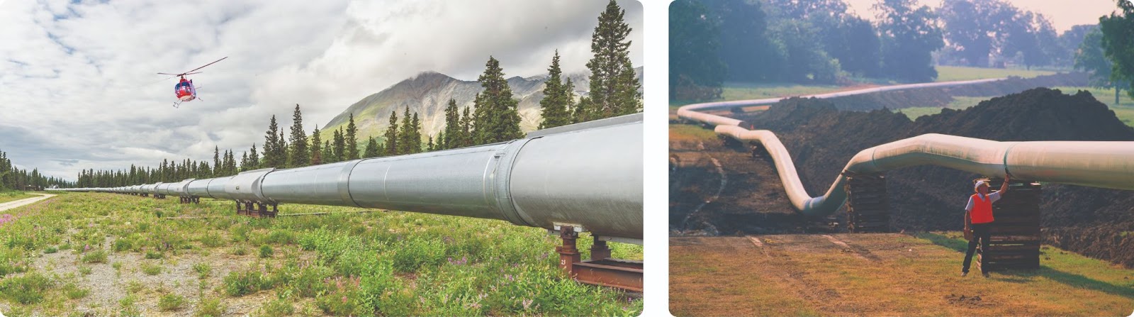
The United States itself has more than 190,000 miles of liquid petroleum pipelines and over 2.4 million miles of natural gas pipelines. Pipeline transportation is safer, more efficient, and emits fewer GHGs than shipping by ship, truck, or rail.

The Current Challenges with Pipeline Inspections:

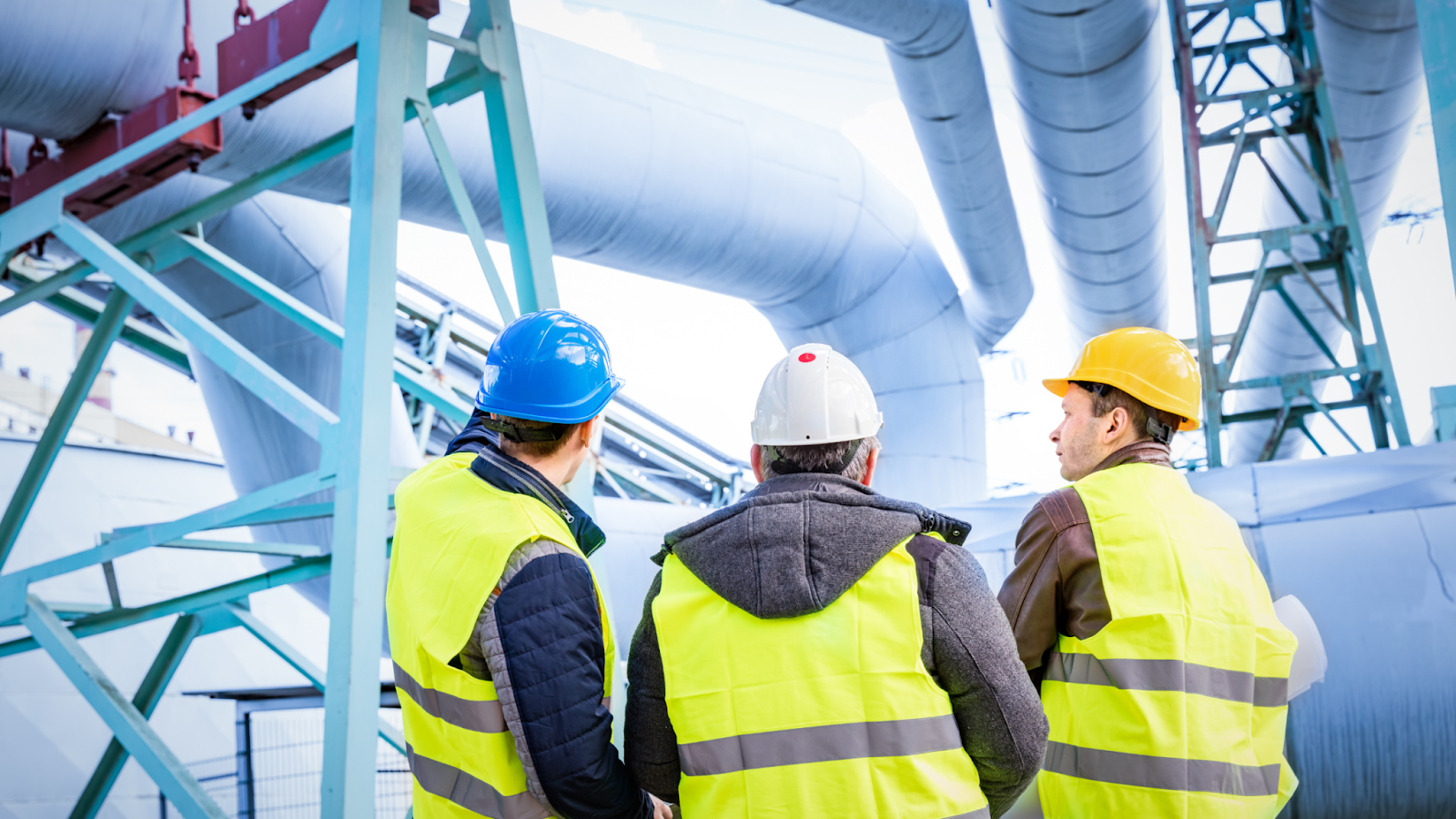
Pipelines are vital infrastructure for the transmission of oil and natural gas, connecting producing areas to refineries, chemical plants, home customers, and commercial demands. However, oil and natural gas are combustible and explosive substances that are typically delivered via high-temperature, high-pressure pipeline networks. Hereby, it is critical to monitor these pipelines to ensure that they are operating effectively.


However, traditional pipeline inspection methods have some issues, such as:

Use of crewed aircraft

Currently, the majority of energy companies use helicopters to monitor encroachment in potential pipeline Right-Of-Ways (ROW). Each expedition costs an average of $150,000, making more regular inspections than every six months almost impractical.

Foot Patrols

Once the aircraft confirms an encroachment, foot patrols, typically consisting of two personnel, are dispatched to these remote locations. Such manual site inspections take approximately 8 hours and cost approximately $500 merely to have a closer look and validate the threat.

conducting pipeline monitoring for oil and gas companies with manual methods

Inability to send crew at all times

Pipelines can be hundreds of kilometers long and can be spread over vast remote locations. Sending operators to such locations can put human life at risk. Hereby, it becomes quite difficult to send inspection teams to cover such areas at all times. 

Time-consuming method

Traveling from one asset to another is frequently difficult. Operators may need to drive lengthy miles along gravel or dirt roads to visit several inspection sites. The distance and hard terrain may need a significant amount of time.

Drone program can help in conducting inspection for oil and gas companies without human intervention

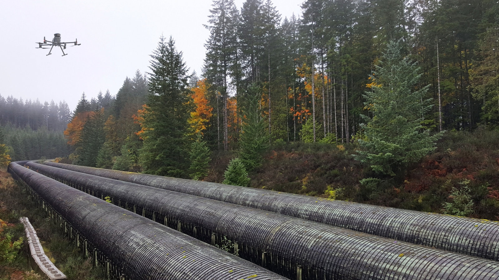
How can Drones with BVLOS Capabilities Help Oil and Gas Companies Secure Pipelines 

Ease of travel between assets

Drone program can help in conducting inspection for oil and gas companies without human intervention

Traveling between assets during inspection operations might become challenging because these pipes can span thousands of meters. The team may be required to travel long distances and to distant regions where there is no adequate road infrastructure.

Operators must travel to the sites, assess the asset, review their data, and then drive to another asset. Furthermore, they must repeat the entire process until all assets have been inspected. This can take a significant amount of time which can be costly for an industry like oil and gas.

However, drones can travel vast distances and reach difficult-to-access locations. Additionally, using drone-in-a-box systems, eliminate the need for continual re-launching, packing, and landing of drones which is majorly faced in manual-led VLOS operations.

Increase worker safety

Oftentimes, assets are located on high terrains or difficult-to-reach locations. Operators may need to set up substantial scaffolding or dangle from ropes to inspect this equipment. Any mistake here can result in severe consequences. Despite the industry's strict regulations and safety standards, health and safety concerns persist. A BVLOS operation eliminates the operator's danger by allowing them to undertake the flight mission from any remote location.

Simplify early detection of pipeline leaks

Example of leak in the gas pipeline is affecting the surrounding environment

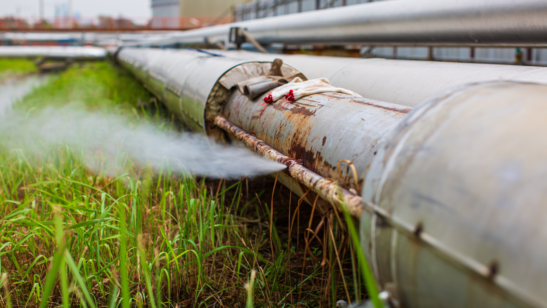
Drones are increasingly being used in the oil and gas industry for early detection of pipeline leaks. By using advanced drone technology including thermal cameras and visual or infrared cameras, these drones help the operators to identify gas leaks in storage tanks and pipelines with greater accuracy and efficiency than traditional methods.

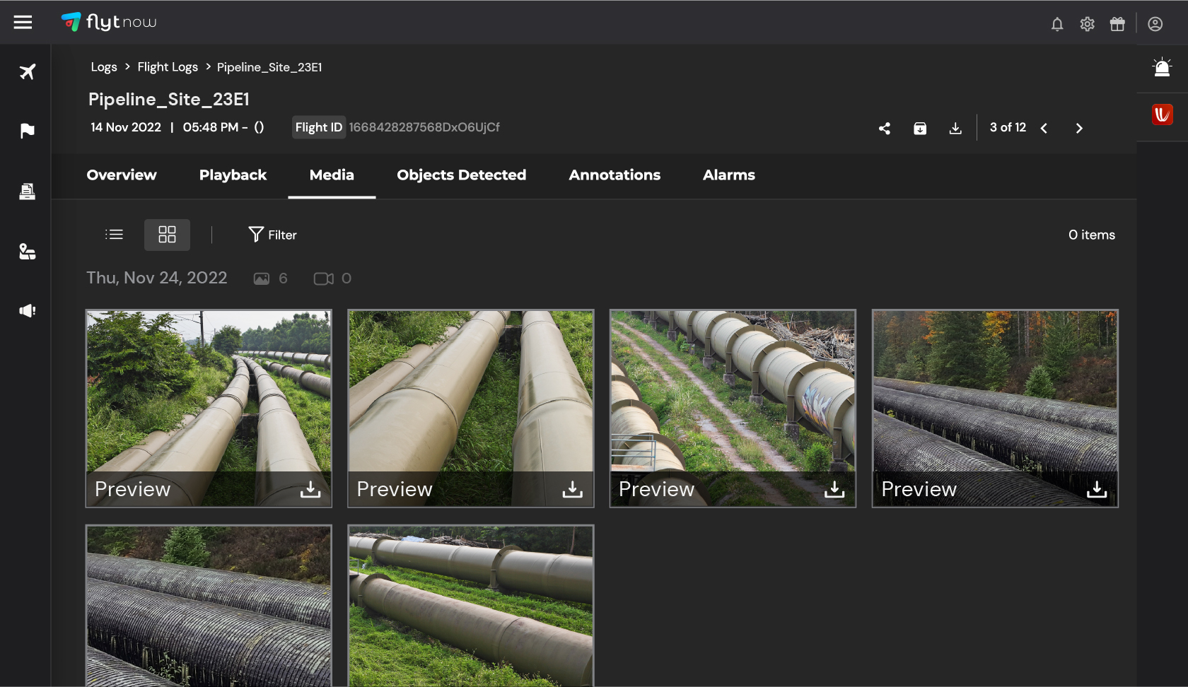
These drones can easily access hard-to-reach areas and capture high-quality photos and videos of the pipelines and storage tanks. These data can be helpful to conduct image analytics for accurate and early detection of potential leaks or damage.

This allows operators to respond quickly and effectively to potential pipeline failure, minimizing the impact on the environment and reducing the risk of accidents. The use of drones also reduces the potential for human error, as operators can monitor the pipelines remotely, without the need for physical inspections.

Reduce heavy costs

Hiring a pilot and a helicopter, for example, can cost thousands of dollars. Regular inspections may become prohibitively expensive and time-consuming. Autonomous drone missions can minimize such costs while also minimizing human dependency.

Utilize readymade data and analytics via automated procedures

A human-led operation requires the operator to drive to the location and visually inspect the asset. Via autonomous operations, drone operators can run pre-planned drone flights and augment the inspection process. The drone will follow its routine, capture and store data which can be further assessed for detailed inspection as per need.

This enables the operator to quantify their assessment with turnkey data and analytics delivered via automated workflows. This simplifies the entire process and backs it up with data, which greatly aids decision-making. 

Ability to scale operations

While examining pipelines spanning thousands of kilometers, it becomes nearly impossible to conduct manual operations consistently. However, autonomous drones can be scaled up and deployed readily to fit the business's needs as they can be programmed to conduct the desired tasks. 

How FlytNow is Enabling BVLOS Operations

BVLOS operations in pipeline inspection

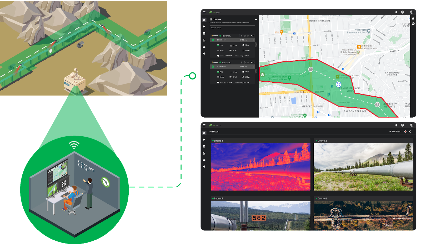
FlytNow is a cloud-based solution that enables the deployment and management of drones in just a few clicks, allowing you to manage your drone operations via a single web-based dashboard for a seamless experience. It helps you lower travel costs, reduce operation rounds, and increase productivity by saving travel time. It is integrated with ready-to-use intelligent modules, like collision avoidance, and precision landing, and integration with drone-in-a-box systems, which further helps you shorten your time to market.

The FlytNow software solution enables project managers to schedule pre-planned or on-demand flights from a command center located miles away from the base station. The drone takes off from the drone nest autonomously, flies its mission, captures real-time videos and images, and uploads them to the cloud.

Store images and videos on cloud and Identify leaks on pipelines with FlytNow's solution

Following the flight, the drone returns to the docking station for battery swapping and storage. These stations can charge up to four batteries simultaneously and swap out the existing battery in less than 90 seconds, ensuring minimal downtime. Furthermore, because it is lightweight, it can easily fit on the back of a pickup truck and be moved from one location to another if necessary.

3rd party integrations in FlytNow, such as Casia G system by Iris Automation for detection and avoidance of cooperative and non-cooperative aircraft, Altitude Angel for airspace awareness, and others, assist to increase capabilities for greater insights and seamless BVLOS operations.


Leveraging Nested Drone Systems (NDS)

How nested drone system helping in pipeline inspection

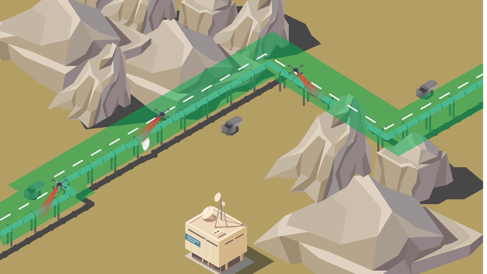
The Nested Drone Systems (NDS) can significantly improve the data collection process and transform how pipelines are inspected. It lets the drone operator conduct long-duration flights without the need to return the drone to the command center to recharge or swap the battery. With the nested drone system, energy companies would be able to quickly scale up, undergo a digital transformation, run safely, and boost productivity.

Nitin Gupta, Founder & CEO of FlytBase, Inc. concludes by stating that “Nested Drone Solutions are rapidly revolutionizing the way repeatable, high-frequency missions are conducted across use-cases. Maintenance of pipelines, spread over thousands of miles, is a great application of this technology with a significant ROI for the end-user.

FAQs

1) How can drones improve the safety of inspections on oil and gas pipelines?

Drones can play a vital role in improving the safety of inspections in the oil and gas industry. With their ability to fly closer to the ground, drones can provide high-resolution aerial data through the use of visual or infrared cameras. This allows for more precise and thorough inspections of pipelines, particularly in hard-to-reach areas. 

By using drones, workers can avoid the potential dangers of inspecting pipelines on foot, such as exposure to crude oil leaks. Additionally, the use of drones allows for earlier detection of leaks, which can prevent potential disasters and safeguard the environment.

2) What are the benefits of using drones for pipeline inspections?

Drones provide several benefits for pipeline inspections, including accuracy and improved technologies. Using drones to detect leaks and identify potential issues can save costs and equipment compared to traditional inspection methods. Drones can also access dangerous terrain and provide quick emergency response. 

In addition, using drones for regular inspection can improve worker safety by avoiding the need for workers to enter hazardous areas. Visual or infrared cameras on drones can monitor pipelines and identify potential issues, whether it be for gas or oil pipelines. With better data and improved maintenance, major accidents can be avoided through the use of drones for pipeline inspections.

3) How can FlytNow help in pipeline inspection using drone-in-a-box systems?

Using FlytNow-powered drones for pipeline inspection, operators can now easily detect any leaks in the pipeline with greater accuracy and efficiency than traditional methods. It allows the team to access difficult-to-reach areas and avoid putting any human in potential danger.

Furthermore, operators can get a real-time video stream of the assets, and also capture high-quality photos and videos of the pipelines and storage tanks. This significantly helps in conducting accurate inspections and detecting potential leaks or damage.

4) What can we expect in upcoming technologies in oil and gas pipeline inspection?

New technologies will include autonomous drones that are packed with a cost-effective platform that will help in inspecting pipelines, provide insight for maintenance activities, and identify human errors. Moreover, they will be equipped with a visual or infrared camera that can detect leaks or damage on its own and inform the team immediately.

5) What are some of the best drones for pipeline inspections in the oil and gas industry?

There are several drones that are well-suited for use in pipeline inspections in the oil and gas industry. Some options include:

  1. DJI Phantom 4 RTK: This drone has a high-resolution camera and RTK GPS for precise mapping and surveying capabilities.
  2. DJI Mavic 2 Enterprise Dual: This drone has a compact design and can fly in challenging weather conditions. It also has a dual thermal and visible light camera for identifying issues in pipelines.
  3. senseFly eBee X: This drone has a long flight time and can fly in autonomous missions to cover large areas quickly. It also has a high-resolution camera for detailed inspection.
  4. Parrot Anafi USA: This drone has a 4K HDR camera and is capable of flying in challenging environments. It is also lightweight and easy to transport.
Read more…

logo-green-blue-citymesh-300x30.pnghttps://flytnow.com/wp-content/uploads/2022/10/logo-green-blue-citymesh-768x76.png 768w, https://flytnow.com/wp-content/uploads/2022/10/logo-green-blue-citymesh-150x15.png 150w, https://flytnow.com/wp-content/uploads/2022/10/logo-green-blue-citymesh.png 796w" alt="citymesh logo" width="300" height="30" />

Headquartered in Oostkamp, Belgium, Citymesh is a pioneer of wireless connectivity with fifteen years of experience in high-end network design, installation, and maintenance. Through the combination of various technologies including 5G, Wi-Fi, smart sensors, and data visualization, they provide B2B smart infrastructure and innovative solutions in a variety of markets that are tailored to the needs of their clients.

They specialize in private 5G services and play a key role in setting up wireless networks in (smart) cities, at events, (air)ports, industrial facilities, and warehouses.


Citymesh-case-syudy-hero.pnghttps://flytnow.com/wp-content/uploads/2022/10/Citymesh-case-syudy-hero-300x204.png 300w, https://flytnow.com/wp-content/uploads/2022/10/Citymesh-case-syudy-hero-150x102.png 150w" alt="drone ready to take off" width="864" height="587" />


Why Genk is Using Smart Tech to Improve Emergency Response

Rapid response in the face of crises and life-threatening situations, such as fires and incidents, is critical for city officials all over the world. Fire departments across nations are implementing new technologies to improve operations and save lives.

Drones are one such valuable tool that has assisted firefighters in improving situational awareness. The imaging technology, software and accessories on board the drone enables the emergency services to gather information more quickly and efficiently in the event of an incident. Some of the major challenges that drones are able to solve include:

  • Incorrect Initial Report of Incident: The emergency services often receive distress calls, either from a bystander at the scene of the incident that does not fully or sometimes even incorrectly describes the incident or from an automated fire alarm.  The emergency services dispatcher allocates resources based on the report, only to discover that they are insufficient in scale and/or type for the actual incident. Response time is critical. Any delay in responding to the incident effectively could result in fatalities or additional infrastructure damage. A local drone team needs time to drive to the scene, get the drone ready and start flying.
  • Lack of Real-time Awareness: Determining the extent of the fire, how to tackle it and the threat it poses can frequently be challenging due to the smoke and obstacles en-route to and onsite. The capacity of fire teams to respond to the situation quickly, adequately & efficiently is limited by these difficult-to-reach locations.

However, drones piloted by humans have certain limitations especially in fast-paced, dynamic environments.

  • Closing the Information Gap: Only the emergency services’ own drone team at the scene and, in best case, the local fire services officer are fully aware of the situation. Streaming the drone’s camera video feed to a local emergency services command center and/or dispatch or other stakeholders is not always possible, reliable or cheap. As a result, dispatchers and fire service officers coordinating from the department’s headquarters, especially in case of large scale incidents, frequently lack complete information, making it difficult to make the right decisions.
  • Inefficient Operations: It is challenging to respond with the appropriate level of resources, equipment & urgency if the team lacks clear knowledge. Sending too little resources can have detrimental consequences, but sending too much resources is problematic too as it draws the limited resources away from other incidents. In addition, heavy fire trucks racing through dense city centers poses its own risks for safety.

To overcome all these obstacles, the Belgian city of Genk decided to implement a combination of autonomous drone-in-a-box technology, AI, and a private 5G network to provide unique insights to emergency services without the need for additional staff.

Mayor Wim Dries emphasizes “Because of the dynamic nature of a city like Genk, we want to keep innovating. As a smart city, we use technology to improve the help we can offer to our residents and to ensure that our police and emergency services work as efficiently as possible. In this way, we can all work together to make Genk a safer place.”

How Citymesh’s Safety Drones is Overcoming these Challenges

The City of Genk recently launched a pilot one-of-a-kind initiative with Citymesh’s Safety Drone solution to assist emergency services in collecting information more quickly and efficiently during accidents with the help of drone technology.

citymesh-dock-1024x578.pnghttps://flytnow.com/wp-content/uploads/2022/10/citymesh-dock-300x169.png 300w, https://flytnow.com/wp-content/uploads/2022/10/citymesh-dock-768x433.png 768w, https://flytnow.com/wp-content/uploads/2022/10/citymesh-dock-1536x867.png 1536w, https://flytnow.com/wp-content/uploads/2022/10/citymesh-dock-150x85.png 150w, https://flytnow.com/wp-content/uploads/2022/10/citymesh-dock.png 1600w" alt="Drone docking station by Citymesh" width="1024" height="578" />

The Citymesh Safety Drone solution is a fully automated Drone-in-a-Box system that allows first responders to immediately deploy a drone Beyond-Visual-line-Of-Sight (BVLOS) to an incident in order to quickly and reliably get a real-time overview of the situation/incident on the ground. The Safety Drone provides first eyes on-scene, even before local response teams arrive, to all relevant stakeholders. It is a Quick Reaction Force (QRF) asset which can be deployed within 2 minutes. 

Citymesh established a private 5G mobile network bubble over the city of Genk to enable both Smart City use-cases on the ground and autonomous Beyond-Visual-line-Of-Sight (BVLOS) drone operations in the air. As it is a private network, it is tailored and built-to-spec specifically for that city and its use-cases which ensures reliable, secure, low-latency, mission-critical communications across the entire 3D volume around the city. In addition, the use of a private 5G network guarantees reliable communications, even during large scale disasters when public 4G/5G networks are saturated or offline.

city-genk-with-5g-drone-technology-1024x667.jpghttps://flytnow.com/wp-content/uploads/2022/10/city-genk-with-5g-drone-technology-300x195.jpg 300w, https://flytnow.com/wp-content/uploads/2022/10/city-genk-with-5g-drone-technology-768x500.jpg 768w, https://flytnow.com/wp-content/uploads/2022/10/city-genk-with-5g-drone-technology-1536x1000.jpg 1536w, https://flytnow.com/wp-content/uploads/2022/10/city-genk-with-5g-drone-technology-150x98.jpg 150w, https://flytnow.com/wp-content/uploads/2022/10/city-genk-with-5g-drone-technology.jpg 1600w" alt="city genk with 5g drone technology" width="1024" height="667" />
High-resolution drone videos and images of the incident scene are  sent in real time to the remote drone operator, the emergency services dispatch and officers, the first response team(s) en-route to the incident or on-site, the mayor and/or other emergency services using the private 5G network. As a result, all relevant stakeholders are fully aware of the scope and severity of the situation, allowing them to make more informed coordinated decisions based on realistic, real-time,  accurate data. 

Read More: Multi-Cam Drone Video Footage for Security, Inspections & Public Safety

As Dominic Knapen, Zone Commander of the East Limburg Fire Brigade highlights,

“Using a drone in emergencies allows us to assess the situation before we arrive on the scene. This saves us crucial minutes that could potentially save lives, and gives us more insight into how best to approach the incident and conduct our intervention.”

How Safety Drone Program Works

When a distress call is placed to the emergency number 112, the Safety Drone is dispatched from the docking station located on the roof of Genk’s  police station located in the center of the city. The drone flies autonomously to the incident site while being remotely monitored by an operator at the Citymesh’s Remote Operations Center (ROC) in Oostkamp, Belgium. 

drone-doc-citymesh-225x300.jpghttps://flytnow.com/wp-content/uploads/2022/10/drone-doc-citymesh-768x1024.jpg 768w, https://flytnow.com/wp-content/uploads/2022/10/drone-doc-citymesh-1152x1536.jpg 1152w, https://flytnow.com/wp-content/uploads/2022/10/drone-doc-citymesh-640x853.jpg 640w, https://flytnow.com/wp-content/uploads/2022/10/drone-doc-citymesh-150x200.jpg 150w, https://flytnow.com/wp-content/uploads/2022/10/drone-doc-citymesh.jpg 1200w" alt="precision landing of a drone" width="552" height="736" />

Remote operators from the ROC can remotely manage, monitor and control the drone and docking station using the FlytNow-powered software. The ROC systems are integrated with the emergency services dispatch systems so the remote operator instantly has all relevant information on their screen when a Safety Drone is called upon. The live HD-video feed and high-resolution images captured by the drone are transmitted in real-time to the ROC, the police forces, fire-brigade & emergency services to accurately anticipate risks and select the best equipment needed for a successful rescue mission. 

The remote operators are in contact with dispatch and local first response teams so they can fulfill their requests of focusing the drone’s cameras on a specific zone or the overall incident scene. They are also in contact with air traffic services to ensure flight safety with respect to other (manned) aircraft.

dashboard-citymesh-1024x509.pnghttps://flytnow.com/wp-content/uploads/2022/10/dashboard-citymesh-300x149.png 300w, https://flytnow.com/wp-content/uploads/2022/10/dashboard-citymesh-768x382.png 768w, https://flytnow.com/wp-content/uploads/2022/10/dashboard-citymesh-1536x764.png 1536w, https://flytnow.com/wp-content/uploads/2022/10/dashboard-citymesh-150x75.png 150w, https://flytnow.com/wp-content/uploads/2022/10/dashboard-citymesh.png 1600w" alt="Monitoring drone operation with the dashboard" width="1024" height="509" />

Because the information is highly sensitive, it is routed through the Citymesh private 5G network and its datacenter.  The data is accessible only to authorized personnel and stakeholders through a secure, internally developed, video streaming platform (DroneHub) in accordance with  the GDPR (General Data Protection Regulation). The data is destroyed after a certain period of time.

How Citymesh is Ensuring Safety in Operations

Furthermore, because the drone flights will take place in urban areas, ensuring operational safety has been a critical factor in the project’s implementation. Several safety features have been included while keeping regulatory requirements in mind. Some essential features include:

  • Parachute Integration: In the unlikely event that the entire system fails, Citymesh’s Safety Drone incorporates integration with an autonomous parachute system so that the parachute will open automatically and the drone would land safely.
  • Failsafes: A number of failsafe events and associated behaviors can be configured by operators using the ROC’s software – FlytNow. For instance, a failsafe action is triggered and the drone automatically returns to the docking station if the connection is lost, the battery runs low, or it loses internet connections. 
  • Smart Return-to-Home: Once the NFZ is set and the drone needs to return to the docking station, instead of using a straight path back home, FlytNow creates a smart path in which the drone returns while avoiding the NFZs.
  • Weather Station Integration: The docking station includes a weather station that records vital information such as temperature, rainfall, and humidity, among other things. If it begins to rain while the drone is in flight and the set threshold is exceeded, the drone will return to the docking station autonomously.

Also Read: How Drones are used for Public Safety & Emergency Response

Citymesh’s Plans for Expansion

The Safety Drone is being used during the day in the first phase of the project, but will later be used for 24/7 operations. The drone is currently flying at a height of 90 meters and covering a radius of 3 to 4 kilometers. As progress is made and the network is expanded,  the drone will be able to cover a 5-kilometer radius. 

Currently, the East Limburg Fire Brigade Zone is using this autonomous technology. The local police force, CARMA, may take part in the second phase.

Citymesh-headquarters-1024x572.pnghttps://flytnow.com/wp-content/uploads/2022/10/Citymesh-headquarters-300x168.png 300w, https://flytnow.com/wp-content/uploads/2022/10/Citymesh-headquarters-768x429.png 768w, https://flytnow.com/wp-content/uploads/2022/10/Citymesh-headquarters-1536x858.png 1536w, https://flytnow.com/wp-content/uploads/2022/10/Citymesh-headquarters-150x84.png 150w, https://flytnow.com/wp-content/uploads/2022/10/Citymesh-headquarters.png 1600w" alt="Citymesh headquarters" width="1024" height="572" />

“We are very enthusiastic about implementing this project together with the city of Genk and the regional emergency services. This project is a unique combination of technologies that will shape the future of our society,” says Mitch De Geest, CEO of Citymesh.

Citymesh provides the full Safety Drone Solution as a service. This means emergency services, fire brigade and police do not have to invest in drones, drone and communication infrastructure nor in the education and training of licensed drone pilots. 

It is important to note that the Safety Drone Solution and local drone teams are not competing with each other but are complementary to each other. Much can be learned from each other. In fact, Citymesh drone operators have been trained in first response tactics by the local first response drone teams. Emergency services sometimes already (or will soon) have their own local drone team that is equipped with small drones. These drive to the incident location and perform flight operations at the scene and swap batteries between flights. Their advantage is that it allows them to be practically continuously in the air and provide a  continuous overview of the situation, especially of long duration incidents, while the Safety Drone has to return to charge/swap its batteries. Their main disadvantage is that they have a longer response time as they need to drive to the scene, get the drone ready and start flying. 

The Safety Drone pilot is currently financed & supported by S-Lim, an organization which unites the Limburg municipalities to enable the region to grow into a smart region via collaboration. The experience and knowledge gained will later be shared with other cities and municipalities in the province.

Nitin Gupta, Founder & CEO of FlytBase, Inc. concludes by stating, “Citymesh’s Safety Drone project has been a revolutionary step toward using drone autonomy for saving lives and improving operational efficiency.  The project will serve as a powerful guide for emergency service providers worldwide.”

Related: Citymesh and the city of Genk launch a test project with a Safety Drone

Read more…

The Aerodyne Group, with its headquarters in Cyberjaya Malaysia, offers drone-based enterprise solutions that are DT3 (Drone Technology, Data Technology, and Digital Transformation).
By using AI and drone data, it addresses challenging industrial problems so that organizations can rapidly scale, undergo digital transformation, operate optimally, and boost productivity.


By 2021, Drone Industry Insights (DII) ranked Aerodyne Group as the world's top drone solution provider, and Frost & Sullivan named Aerodyne Group the Asia Pacific UAV Services Company of the year.

Related: Pipeline Inspections using Nested Drone Systems

It has become necessary to monitor the existing and potential pipeline right-of-ways, which span over 1630 miles, in order to identify encroachments. The two main issues with the current inspection method are as follows:

  1. Use of crewed aircrafts: Currently, the majority of Malaysian energy companies use helicopters to monitor encroachment in potential pipeline Right-Of-Ways (ROW). Each mission costs an average of $150,000 USD, making inspections more frequent than every six months practically impossible.
  2. Foot Patrols: Once the aircraft confirms an encroachment, foot patrols, typically consisting of two personnel, are dispatched to these remote locations. Such manual site inspections take approximately 8 hours and cost approximately $500 USD just to get a closer look and validate the threat.

Artboard-7-min-1024x286.jpg

To address these challenges, Aerodyne has recently launched the first-of-its-kind localized beyond visual line of sight (BVLOS) drone project in Malaysia, called Aerodyne FULCRUM. The project employs a modular Nested Drone System (NDS) to transform the way these pipelines are inspected digitally. By implementing this system, Aerodyne intends to improve the safety, efficiency, and quality of data collection and analysis in the energy sector.

Artboard-1-copy-2-1024x576.jpg

FULCRUM intends to use a combination of a Hextronics Atlas 300 docking station compatible with the DJI M300 RTK drone and FlytNow’s software solution to carry out these operations on such a large scale.

aerodyne-command-center-1024x768.jpghttps://flytnow.com/wp-

How it Works

The FlytNow software solution enables project managers to schedule pre-planned or on-demand flights from a command centre located miles away from the base station. The drone takes off from the Hextronics drone nest autonomously, flies its mission, captures real-time videos and images, and uploads them to the cloud.

Following the flight, the drone returns to the docking station for battery swapping and storage. The Hextronics Atlas station can charge up to four batteries simultaneously and swap out the existing battery in less than 90 seconds, ensuring minimal downtime. Furthermore, because it is lightweight, it can easily fit on the back of a pickup truck and be moved from one location to another if necessary.


how-it-works-aerodyne-1024x605.jpg

How Aerodyne Plans to Deploy Drone Docks along the Pipeline

Owing to the complexity & the scale of the project, Aerodyne, leading the operations effort, has planned the deployment in phases. In the initial phase, Aerodyne will strategically locate thirteen units of FULCRUM systems at multiple sites in the control stations compound along the ROW. Each drone will collect data and monitor the encroachment for up to a five-mile radius around the nest, on a 24/7 basis.

Once phase 1 is successful and the value proposition is established, the following project stages will be put into action. Aerodyne anticipates beginning BVLOS operations up to 60 miles by September 2022. Long-range operations such as these will necessitate additional complexities, such as integration with onboard detect-and-avoid technology and a UAS traffic management system.

How did Aerodyne receive the BVLOS approval?

Special BVLOS authorisation was granted by the Civil Aviation Authorities of Malaysia (CAAM) in order to carry out these operations. The Joint Authorities for Rulemaking on Unmanned Systems (JARUS) Specific Operations Risk Assessment (SORA) is used in Malaysia. The JARUS SORA requires both ground and air risk assessment and related Specific Assurance and Integrity Levels (SAIL). Operational Safety Objectives (OSO) are then driven by these SAILs and must be met.

To reduce the risks on the ground, Aerodyne decided to fly over unpopulated areas and set up geo-fences around the pipeline ROWs. Additionally, each drone is equipped with a parachute to reduce ground risk. Notices to Air Missions (NOTAMs) are released during drone operations to lessen air risk. A centre for operations also communicates with air traffic control (ATC) through the radio and provides real-time flight telemetry data to ATC.

The BVLOS approval in this instance took months. It involved a formal application meeting after a pre-application meeting to submit a draft SORA plan to the CAAM. Prior to capability demonstrations, the last phase before approval, there were document reviews and evaluations of the SORA, the concept of operations, and risk mitigations.

Read more…