Howard Gordon's Posts (24)

Sort by

Fun with planes, parafoils and robots

SnowflakeFigA.jpgSnowflake is a collaboration between Naval Postgraduate School and University of Alabama at Huntsville to develop single and multiple autonomously guided parafoils. The project, described in detail here, uses an Arcturus T-20 UAV to launch the parafoils and a Surveyor SVS-based robot with Inertia Labs Renegade base to autonomously locate the parafoils after landing.

We had the opportunity last week to view Snowflake field tests at CIRPAS McMillan Airfield. The Arcturus launched a pair of Snowflake parafoils from 3500-ft, and upon touchdown, the Snowflake controller transmitted GPS coordinates that were relayed to the robot. The robot then autonomously moved to the transmitted coordinates using a script written in picoC. We witnessed 3 successful UAV launch and robot retrieval cycles. Future tests will include drop of a smaller version of the Surveyor robot by parafoil.

IMGP1794.jpg
Arcturus ready to launch. Note underwing pod carrying the parafoil.

IMGP1806.jpg
Parafoil approaching the ground

IMGP1808.jpg
Robot receives parafoil GPS coordinates

IMGP1818.jpg
Robot driving through the grass to reach parafoil

IMGP1839.jpg
Arcturus approaching touchdown

Read more…

Shrediquette open source tricopter

Tricopter - The Movie... from W. Thielicke on Vimeo.

From http://www.lecun.org/blog/index.php?entry=entry091130-130224..."The Shrediquette is a tri-rotor helicopter built by William Thielike from Germany. William is a PhD student in biology, who seems to have many talents: micro-controller system design, control, mechanical design, flying contraption construction, as well as film making.His tricopter is built around an Arduino Pro Mini micro-controller. Oddly, William didn't use the Arduino development tool and C/C++ programming language: he wrote his software in Bascom, a dialect of BASIC.The yaw control is performed by rotating the tail boom with a servo. This very unlike the more conventional servo-less yaw control of quadcopters, but it's practically unavoidable for tricopters.Much of the material is available for download, including the schematics, the PC board Eagle files, and the Bascom source code."
Read more…
Here's an updated version of the software-based horizon finder for SRV-1 Blackfin. An actual slope and intercept is now being computed, and some filtering has been added as well ...Here was the original post ...
Noting the interesting discussion about optical flow and horizon finders in this thread, I undertook to add a simple horizon finder to the SRV-1 Blackfin Camera firmware. The algorithm uses a basic edge detection function that is already build into the SRV-1, dividing the image into 16 columns and searching from top-to-bottom for first edge hits. From the video, it appears that the edge threshold could be set a bit lower, but the results are pretty good without any tuning or filtering.The Google Code project is here - http://code.google.com/p/surveyor-srv1-firmware/ . Next step is to add a least-squares fit to draw a line through the edge segments and then compute pitch and roll angles.
Read more…
bfin-gps-v1a.jpg
We just received the prototypes of a new sensor board we developed for outdoor navigation. This navigation module includes a Honeywell HMC6352 compass, ST LISLV02DQ 3-axis tilt sensor, Analog Devices AD7998 8-channel A/D, and interface to GPS (we're using the Locosys LS20031). The board measures 31mm x 38mm (1.25" x 1.5"), and weighs around 5gm without GPS (18gm with GPS).

Though designed for the Surveyor SRV-1 Blackfin camera and SVS, we are using I2C interfaces to the compass, tilt sensor and A/D and UART interface to the GPS, with everything running at 3.3V, so the module is not specific to Surveyor. The 8-channel A/D enables interface to other navigations sensors such as gyros, barometric pressure, thermopiles, infrared range sensors, etc, supporting the development of a complete IMU solution. The prototype module, as seen above with the Locosys GPS, has an unfinished appearance without solder mask or silk screen, but these features will be present in the production version. We will likely ship the board without headers, but the prototype is functioning properly and is already supported in Surveyor firmware.

The schematic is found here.. Component placement is shown here:
bfin-gps-v1.gif

Bottom view (no solder mask):
bfin-gps-v1c.jpg

The navigation module is expected to be priced at $150 including Locosys LS20031 5Hz GPS, and we should have production quantities available in 30 days. If interested, please send an email to support@surveyor.com
Read more…
Since posting our Google Android G1 control console for the YARB robotic blimp, there has been a fair amount of interest in an assembled version of the 66" blimp, so we have decided to make YARB available for purchase.Cost is $875, which is $200+ more than the cost of buying the various kit components, or equivalent to the cost of approx 8 BlimpDuinos , but some users are less DIY, and it is somewhat easier for us to support a fully assembled version.The YARB controller includes a 500MHz (1000MIPS) Blackfin processor, 1.3 megapixel camera with 3.6mm or 2.2mm lens, 802.11bg Wifi radio, motor and servo controllers for vectored thrust, and 800mAh battery + charger. Firmware is open source, and includes support for 4 Maxbotics EZ1 sonar modules and the Honeywell HMC6352 compass.For more information, visit -http://www.surveyor.com/YARB.htmlhttp://www.surveyor.com/blackfin/http://surveyor-corporation.stores.yahoo.net/yarobl.html
Read more…

The open source Google Android G1 phone seemed like an obvious platform for wireless robotic control, so we created an Android-based console. After running this first with the ground-based Surveyor SRV-1 robot, we made a few small modifications and used it to control the Surveyor YARB. The tilt sensors in the Android phone work quite nicely for rotor control - we have proportional steering so the amount of tilt controls the amount of power, and live video is displayed on the Android screen from the blimp's onboard Surveyor SRV-1 Blackfin camera, carried via the same radio channel that sends the control signals.The project is hosted on Google Code at code.google.com/p/srv1console/ as well as www.surveyor.com.Here are some first flight videos -
Read more…

Interesting 900MHz radio

Take a look at http://www.avalanwireless.com/product_list.htm. Click on OEM Radio Modules and check out the AW900mSPI.The AW900m is a 900MHz digital radio with lots of range and throughput - 1.54Mbps radio channel with 900-1100kbps delivered. SPI/UART version will retail for $129 per card. These look really good - I should have a couple of modules shortly and will report on performance. The UART version is actually designated AW900mUART.
Read more…

YARB flies again - now with 3D stereo vision


YARB (yet another robotic blimp) is back in business, now carrying a new Surveyor SVS (stereo vision system) controller with a pair of Blackfin cameras. The new rig weighs about the same as the previous single-camera setup with added sensors. It is actually a bit too light, so ballast has been added using washers held in place on the Wifi antenna.

There is a new simplified console that steers via 4 arrow keys for direction (up, down, left, right), the return key for reverse, and the spacebar to stop motors. Control via keyboard seems more direct than using mouse clicks, though the console will be able to steer via mouse clicks directly on the display window - this would work nicely with portable phones (iPhone, Android, etc).
Viewing of the live or archived video requires anaglyph (red/cyan) 3D glasses 3D_glasses_red_cyan75.gif. Here is a short 3d stereo video clip captured from the blimp ...
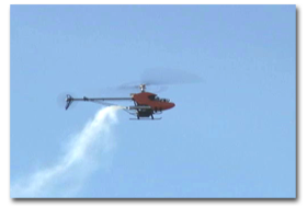
yarbsvs1.avi (5.2MB)3D_glasses_red_cyan75.gif
It is fun to fly YARB around using stereo vision, but the real point of this exercise is to develop the functions that compute disparity between views of the two cameras in order to create a depth map. Similar to human depth perception, this enables the robot to measure distances to objects and obstacles without any additional ranging sensors (e.g. sonar, IR, laser). Work has already started to develop this capability in the Blackfin firmware.
Read more…

SmallParts.com

SmallParts.com is a pretty handy website for prototype builders - I stumbled across them when looking for nylon fasteners and found lots of other interesting stuff - gears, belts, cables, springs, bearings, shafts, tools, etc. Prices are reasonable, though freight is a bit expensive - it cost $8 to get $15 worth of parts via UPS, but otherwise, no complaints. In any case, the site is worth a visit.
Read more…

Stanford Autonomous Helicopter Project

tempest-thumb.pngFrom Yann's Techno Toy Blog ...Stanford Autonomous Helicopter Project has developed new reinforcement learning techniques to stabilize and control their helicopters. The developers have been able to teach their heli to perform just about every aerobatic figure imaginable. However, the heli has no on-board intelligence. Instead, data is fed from onboard GPS and IMU with serial outputs directly into Xbee Pro modules. The signals are received by a PC on the ground, which enables operator control via the training port of a conventional R/C transmitter.
Read more…

simple VTOL airplane with vectored thrust

I just ran across this on Yann LeCun's blog - Yann is a professor of mathematics at NYU, a leading authority on neural networks, and an R/C enthusiast.This is a conventional airframe with two sets of vectored motors (similar to what we're doing with the blimps). Yann reports that two rotors turn clockwise and two counter-clockwise on a diagonal. Stabilization and control is accomplished with a combination of conventional gyros and channel mixing.
Read more…
Along with a couple of Tri-Turbofan toy blimps, one of the purchases for my early blimp experiments was a Plantraco MicroBlimp, which is the company's current offering. After ordering, I found out that it was too small to carry any useful payload, so I left it in the box until deciding to take a closer look yesterday.Plantraco seems to specialize in really small radio controlled aircraft. They tend to be somewhat expensive, but there are some cool designs. Their current blimp design bears no resemblance to the original Tri-turbofan except that it still uses 3 motors. However, these motors are really small - approx 6mm diameter. The motors may have been designed for pagers or cellphones - I haven't worked with motors this size, but they seem to have a lot of power. These seem to be similar in size to the pager motors sold by Solarbotics. Props are 45mm diameter (1.75"), and everything is attached to a very thin flexible circuit board (0.63mm or 0.025") that's been trimmed to shape. The entire circuit assembly with motors weight 8gm, and total weight with the lipoly 90mAh battery is 10gm. I really like the small motors - I'll have to get some samples from Solarbotics just to see how they compare with the larger N20's.

Two other interesting features - the battery pack uses magnets for the battery terminals, so installing the battery pack is quite simple. I read somewhere that they have a patent pending on this, so someone should do a patent search before taking the idea into production. Also, they use magnets for ballast - also a slick idea (more elegant than kids' eating utensils). Only problem with the magnets is that they will probably screw up the local magnetic field for compass readings, but still something to consider.

The blimp itself is 20" diameter, so it holds approx 2 cu ft of helium. I didn't bother to weigh the envelope, but would guess 20gm, so with electronics, the total package weighs 30gm. I had to add more than 20gm ballast to get neutrally buoyant, so there's a lot to be said for minimizing the weight of the motors and electronics.One additional observation - I don't really care for the 3 motor propulsion system for blimps, as compared with two motors plus a servo for thrust vectoring. However, the 3 motor approach is simple, light and cheap.
Read more…
I attached some additional sensors today - a pair of Maxbotics EZ0 ultrasonic ranging modules and a Honeywell HMC6532 I2C compass. Also, I added an extender to the camera module to point downward about 30-degrees and I finally adjusted the focus. I think the camera angle is pretty good now - the wide angle lens has a field-of-view of approx 120-degrees, so the bottom of the frame captures objects almost directly below.I haven't yet filtered the sensor data. The ultrasonic data is pretty solid - the forward looking readings bounce around a bit, but the download readings are fairly consistent. However, I am thinking about going with a narrower beam module - probably the EZ1. Also, I would like to add a couple of side-looking modules to enable some degree of mapping capability.The compass is less consistent, but I suspect the may be due to magnetic field interference from the motors. When I was recording, I wasn't paying attention to the readings, so I will have to run some tests to see if the compass reading change depending on whether or not the rotors are firing.Here's a snapshot of the gondola with the additional sensors -

I'll work on cleaning up the data a bit, and then will start to write a script (there's an onboard C interpreter) to let the blimp wander around on its own, perhaps following a course based on heading. After that, I will add some logic to use the camera to lock onto an object and follow it around while maintaining altitude and avoiding collision - that will be a bit more challenging.Here's a short video clip of the latest test -
Read more…

YARB 1.0 update - first untethered flight

Here's a video clip from YARB 1.0's first untethered flight. I captured the video while sitting in my office while the blimp explored the hallway and front room (the dogs completely ignored it). The camera is a bit out of focus, and the afternoon light washed out the picture somewhat, but you get the idea.You can see the modified console with buttons to vector the props and invert the video. I'm actually surprised with how easy it is to pilot YARB - it is very responsive. Next step is to add the ultrasonic sensors and compass.
Read more…