Roger Sollenberger's Posts (50)

Sort by
3D Robotics

3689590495?profile=original
On the heels of the Arcturus JUMP flight, thought it might be nice to announce that Adam Sloan and John Hampton, the two-man crew that is BirdsEyeView Aerobotics, have just developed the first RC-accessible VTOL drone, the FireFly6—and it runs on APM.

For the uninitiated, a VTOL (Vertical Take-Off and Land) is a fixed-wing aircraft outfitted with propellers that can take off and hover like a copter, but can also shift into a plane’s forward flight mode. VTOLs have unique advantages over planes and copters alone. For one, it’s hard to find big fields to launch and land a plane, and in many parts of the world, such as rainforests, cities, or islands, it’s especially difficult. On the other side, multicopters can only fly for a short time, so if you’re making a delivery or want to cover a large area, you need the flight time and forward speed that a plane provides.

VTOLs have a reputation for being difficult to develop and manage. For one, there's the complicated mechanics—fully actuated roller discs, variable pitch, with lots of moving parts; because it's all so unreliable, VTOL hasn't done well in manned development. However, Sloan says that the recent explosion of multi-copters has finally brought accessible technology to VTOL and made it more viable: fixed-pitch, electric motors, and not as many things (or people!) to break.

Sloan says their craft is unique in a couple ways. The form factor is a flying wing with the Y6 propeller configuration built in. Rotating propellers keep the craft's cross-section in the wind to a minimum—unlike the "tail-sitter" form, a vertical wing that then flips into forward flight, and which Sloan calls "basically a flag in the wind." Also, their "bridge" electronics allow you to plug in the required hover controller and optionally a forward flight controller. The bridge coordinates between the two, operating a chain drive transition between forward and hover. 

And his business partner John Hampton points out their model is redundant: if something goes awry in forward flight, it flips into hover mode and corrects itself.

As for the choice of APM, Sloan says, “I’ve flown a lot of controllers, and APM is easily the best for forward flight.” And true to APM’s roots, Sloan wants to keep his platform open. “We’d like to see the technology trickle down to everyday users.”

To learn more about the FireFly6, click here.

Read more…
3D Robotics

Two Photos (Larger)

This summer Jesse Casana will fly a drone over northern Iraq—in the name of archaeology. “It’s definitely not something a lot of civilians do,” he acknowledged with a laugh.

Casana, a professor and researcher with the University of Arkansas Department of Anthroplogy, recently made news after using a drone to reveal a buried prehistoric Puebloan community in New Mexico. The thousand-year-old community, known as “Blue J” and located just south of the famous Chaco Canyon archaeological site, consists of about 60 homes clustered around what was once a small spring. The homes and walls had been buried in part by the collapsed structures themselves, but also by centuries of windblown sandstone and silt. The full extent of the community lay unseen and unknown until last summer, when Casana’s drone flew overhead.

Casana and his team, including Professor John Kantner of the University of North Florida, used thermal imaging to reveal the sub-surface structures. “We can see where each one is, where the houses are, where the courtyard is; in a couple places we found subterranean ceremonial rooms, called kivas, which we weren’t expecting at all.”

Archaeologists have been using aerial thermography since the 1970s, but the technology is labor-intensive: You need high-resolution thermal images of a large area, and because of differences in diurnal heating and cooling, you also need to take them at the right time of day. Imagine a wall versus the type of soil it’s buried in: At some times of day they have the same temperature and to a thermal lens appear indistinct, but because the materials capture and lose heat at different rates, at other times that wall becomes visible. “We have to do a lot of flights,” Casana said.

He expressed a keen interest in the 3DR Aero, because of its affordability (a thermal sensor alone costs $7,000) and its autonomy—“I’m a terrible pilot!”—and because it offers several advantages specific to archaeology. “Drones allow us to cover huge areas. You can time flights exactly, and you don’t have to worry about precise weather conditions. Plus they can help us map things very quickly—there’s a limited time, and hundreds of sites.”

So while Casana’s pleased about the Pueblo discovery, he seems even more sanguine about the future: “More importantly, our research demonstrates the potential of this method to be used more broadly, around the world.”

The Blue J study was published this month in the Journal of Archaeological Science. Read it in its entirety here.

Read more…
3D Robotics

9bf24cf8054fec2a450f6a706700dc17

Robert Blair (http://diydrones.com/profile/RobertBlair), a fourth-generation wheat farmer living in Kendrick, Idaho, has been using drones in precision agriculture since 2007. “Folks think we’re standing out there in our bib overalls with a pitchfork,” he says. “But take a look at our technology. Our tractors, our auto-booms, even apps now for crop scouting. We’re all automated.”

Blair, whose family farm dates back to 1903, the year of the Wright brothers’ first flight, has been lobbying the FAA on behalf of the agriculture industry for six years now. “No one else seemed to be speaking up, so I just started putting my name out there,” he says. But he still can’t get through. In fact no one from the agriculture industry, including the American Farm Bureau, which represents 6 million members, has a seat on the FAA’s rule-making committee.

“Since agriculture has been targeted as the first industry that UAVs will enter commercially, it makes sense to have someone from agriculture representing that industry,” Blair says. “But so far there isn’t. Why, I can’t say.”

Overseas, drones have already been cleared for agricultural use; in Japan drones have been applying pesticides for fifteen years. (Blair says that’s because Japan’s version of the FAA doesn’t have to clear them; their department of agriculture does.) Drones can monitor water levels, soil quality, and crop stress, health, and vigor, which will allow farmers to apply resources more tactically. The public wants less water, and fewer pesticides and chemicals used on crops, and Blair feels drones will help farmers rise to the steep challenges that they face—namely feeding 9.5 billion people by the year 2050.

First, though, Blair says we need to develop UAV systems that can in fact do what the ag industry wants to do—and that can start with basic scouting. “We go out there and scout crops every week, two weeks. We need to create technology that can help us do that.”

But Blair wants to balance that verve, reminding us that we have to be careful and diligent about how we bring UAVs out. And in his mind, the first step is responsible and proactive legislation—perhaps, like Japan, through a farm bill—“before the Wild West ruins it for everybody.” Besides, the technology is not quite there, so we have to check our promises: “People are strapping a GoPro camera on there and saying that’s a UAV—well it’s not.”

So Blair isn’t buying the farm just yet. He routinely flies to D.C. to meet with his delegates, and this year will speak at four national UAV conferences. In December, the AP ran a lengthy piece spotlighting his work. He’s also designing his own systems, built around Arduino, and is reaching out to industry partners like 3D Robotics. “There are very few times when a person can effect positive change in an industry they love,” he says. “Every year this industry waits, we’re losing potential.”

To learn more about Robert Blair’s efforts, check out his blog, The Unmanned Farmer.

Read more…
3D Robotics

3D Robotics Talks Precision Ag

3689586122?profile=original
Last month, Brandon Basso, Senior Research and Development Engineer at 3DR, discussed the application of drones in agriculture at the annual Nebraska Crop Consultants Symposium in Las Vegas. Though that symposium name sounds extraordinarily specific, the crop consultants in attendance represented a huge swath of American heartland: over a million acres of cropland among them.

Similarly, the specific application of drones for them means wide-reaching consequences. This year, the symposium invited a number of outside speakers, Basso included, to speak about precision agriculture. Crop consultants spend huge chunks of money annually on chemicals and pesticides from big companies like BASF to ensure that crops aren’t lost to bugs and blight. Right now there’s no safe, efficient and reliable way of applying these chemicals surgically, so if anything there’s an excess blanketing of these crops, which obviously isn’t ideal for the crops, or for bottom lines.

Basso discussed the potential of using drone technology to monitor and map farms daily, giving consultants and farmers high-resolution, real-time reports on crop health that they could then use to inform precision-agriculture decisions about which specific areas to treat on which days, and which to leave alone. The talk is specific, thorough, and informative, and you can watch it in its entirety here: https://www.youtube.com/watch?v=lFTft9nauI0

Read more…
3D Robotics

3689585252?profile=original

Following a full year of planning and development, 3DR’s San Diego engineering department will officially move into their new Otay Mesa facility on Saturday. At 32,000 square feet, the new facility is large enough that they've built a specially designed indoor flight-ops arena. More importantly, it's large enough that it also gives our ever-expanding engineering department room to grow: They’ve got some “toe room” in an unfinished space upstairs.

The new location also brings engineering closer to the manufacturing department in Tijuana. Tim McConnell, 3DR’s director of engineering, has said that close collaboration between the departments has grown more and more important to the production process. From Otay Mesa, engineers will now only have to make a short commute to the factory to work on design and construction. All engineers will have SENTRI passes to expedite border crossing.

It’s taken a year of work to get to the new building, but it’s got an untold number of great years in it. Congratulations, guys!

Read more…
3D Robotics

3689584805?profile=originalLast week, Dries Raymaekers wrapped up a seven-day drone seminar in Lima, Peru. Dries has started a small business in Belgium called Usense, building UAVs for mapping purposes and leading workshops on how to operate them. In cooperation with the KULeuven, and in the framework of the North-Sout-South project sponsored by the Belgian inter-university council, VLIR-UOS, Dries gives international workshops on drone mapping for developing counties. But he's no ambassador, he says: "I'm just a lucky guy who gets to fly drones in South America."

Dries studied bio-engineering at Leuven University in Belgium and Purdue University in Indiana. When he's not traveling or flying drones, he's a researcher at the Flemish Institute of Technological Development (VITO), working on remote sensing technology. He's been building his own UAVs for three years now, ever since he saw the great potential of UAV for mapping purposes. At first, though, available commercial platforms were too expensive and "black-box-like," and Dries wanted to integrate his own sensors and maintain his drones himself. Dries tried a trainer plane, the Bixler, and integrated it with the APM1 autopilot and a small camera to create his first maps. Usense was born.

He's traveled to Colombia and Peru already, with three more countries on the docket—Cuba, Ecuador and Ethiopia. Over four days at La Molina, Peru's National Agrarian University, Dries taught university students to fly a drone, understand the software and sensor technology, and demonstrated possible applications. They spent the next three days high up in the Andes mapping agro-ecosystems. In Peru, drones will enable researchers and farmers to inventory and improve agricultural production. Both the maps and digital terrain models can guide the local farmers to optimize their irrigation systems and fertilization schemes and help them determine which crops to plant on which fields.

Right now Peruvian farmers depend on satellite imagery for crop mapping, but drones can fly under the clouds that often obstruct satellite views—especially valuable during the rainy season when productivity is high and reliable imagery is more urgent. Dries outfit the plane with a normal RGB camera, and used an infrared camera to gather information on vegetation. By the end of the week-long workshop, Dries had given the students training, RC flight experience in real life as well as with a flight simulator, their own plane, a remote controller, batteries, and software.

Dries is a proponent of APM and open-source technology. The people he works with don’t have a lot of money, and to really learn how to fly, first-time pilots have to be able to afford to crash and then pick it up again. Workshop attendees also see potential in being able to build and tune their own drones and use them for their own applications.

For instance, Dries will travel to Ethiopia where they'll use drones to fight malaria spread. The 3D maps can help them identify small ditches—in which mosquito larvae survive during the dry season—to better monitor and control malaria hotspots.

“This work doesn’t end with the workshop,” Dries says. “These researchers will need to pick up the technology, invest in a local team and their own hardware, and start flying for themselves.” Of course, there's the potential of making money, in topography, mining, and other commercial applications beyond his workshops. “But this is what makes the project sustainable.” For this they need low-cost, reliable, and adaptable platforms, like the USENSE-X8 which is based on open-source and COST component.

In the three years of flying his planes (first based on the Bixler, now a strengthened X8) in all kinds of climates, Dries's free APM autopilot has exceded his expectations: he hasn't crashed once during an autopilot mission.

For this he's grateful to Tridge and the other developers in the DIYD community. Other than a few issues with power supply, which is solved as of APM2.5, Dries says the only downside of APM as compared to commercially available UAVs such as Gatewing or Sensefly is that it's not yet as user-friendly for new pilots who need to spend more time learning to fly and operate the electronics. But he says the final output—the imagery—is comparable to both those brands, "plus you're able to fix your plane yourself."

Regarding this imagery, he says we really should be careful what to promise to farmers or other end-users: "Right now you can easily make an ortho-mosaic and 3D model, but more research is needed to derive the required application-specific information—if a farmer is interested in fertilizing, he can get the imagery and visuals, but how does he know how much fertilizer to apply? What you need now are vegetation growth models to relate these images to plant physiological properties. The job of the community—and universities/research institutes—is to investigate in application-specific algorithms."

To learn more about Dries and his company, Usense, click here

Read more…
3D Robotics

3689582819?profile=original

Matt Waite thought he was going to die a paper reporter, but now he says it looks like the papers are going to die first.

In November of 2011, Waite founded the first journalism drone lab in the world at the University of Nebraska. It was also the first journalism drone lab in the world to get a cease and desist letter from the FAA.

The story that drew the FAA's ire was an October 2012 report Waite and his students put together on that year's drought, one of the worst in the Nebraska's history—meteorologically worse than the Dust Bowl. (Pictured above; read his DIY Drones post about that story here.) Waite and his student crew flew in a rural area, nowhere near airports or populated public land, but because Waite was an employee of a public institution, the FAA demanded a certificate of authorization.

Waite is now on a lecture tour, addressing the state of FAA regulations and how they could impact journalists in the future. He's scheduled lectures at universities across the country, including at San Diego State (March 25) and the University of Texas (April 4).

“Many states are considering laws that restrict drones," he said, "and some of those laws are hostile to the idea of the free press using drones to do journalism.”

For instance, he points out that the Texas state legislature recently passed a bill that made it a crime to distribute photographs of private property taken from above eight feet. The eighteen exemptions to this law apply to industries like oil and gas, ranching and film, but, interestingly, not to broadcast TV. Texas is also one of six states selected by the FAA for UAV testing.

Waite anticipates the next five years will be rough. But because he believes almost all news organizations will soon use UAVs, he’s optimistic the FAA will be smart enough to make any eventual regulations content-neutral, so they don’t invite First Amendment fights.

Citizens have the constitutional right to photograph in public, with no expectation of privacy. The question now is how far in the air does that right extend? So far the courts have ruled that the air is a public place: Not private, but out in the open.

“Ten years from now, we’ll be bored with it,” Waite shrugged. “The same way we look at the first camera phones now.”

To learn more about the Journalism Drone Lab, click here.

Read more…
3D Robotics

3689582446?profile=original

For the past ten years, Patrick Meier (DIYD: PatrickMeier) has worked at the intersection of technology and humanitarian response. A Harvard Humanitarian Initiative Fellow, a National Geographic Emerging Explorer and the founder of the iRevolution blog, Meier’s humanitarian work centers on self-help and mutual-aid: Empower people to respond locally and build more resilient societies. He believes that UAV technology and user-generated aerial imagery, coupled with widespread mobile access, will greatly increase a community’s ability to self-organize, and that this technology has a vital role to play in the future of humanitarian and disaster relief efforts.


When and why did you first start flying?

I've long been interested in RC planes/helis and civilian UAVs, but I only got into quadcopters more seriously a year ago when I began writing and speaking about their potential use for humanitarian response. Since I don't like talking in the abstract about hypothetical applications of new technologies, I decided to jump into the DIY Drones space head first, and haven't looked back. This practical experience coupled with everything I've learned thanks to DIY enthusiasts around the world has been invaluable when speaking with my humanitarian colleagues.


When did you first realize UAVs could be vehicles for good?

I've been closely following the commercial startups in this space who are starting to "democratize" access to personal UAVs by producing cheaper/expendable, safer, and easier to use aerial robots. Colin Guinn, who recently spoke to 60 minutes, expects that in the future 1 in 5 people will own some kind of UAV. This is what most excites me with respect to humanitarian and relief work.

A lot of my work is applying advanced computing to make sense of "Big Data" generated during disasters. This Big Data is made possible by the widespread access to mobile phones, which generate the vast volume of crowdsourced content that gets shared on social media during disasters (volume obviously varies by connectivity).

All the data that eyewitnesses produce and share can be invaluable for immediate damage assessments. Following Typhoon Yolanda, for example, we used a microtasking platform called MicroMappers to tag and thus make sense of a huge number of tweets and images in just a matter of days (even though the server crashed half the time). And when I was in the Philippines with the UN, I came across a number of UAV disaster-response initiatives like Danoffice IT. Others, like the xUAV project work directly with grassroots communities (picture below). But these groups can't be everywhere at the same time. Meanwhile, companies like 3DRobotics and AirDroids are radically changing the micro-UAV market, which means these flying robots will soon be as cheap as smartphones, thus paving the way for further democratization.


Screen Shot 2014-03-15 at 1.07.26 PM.png

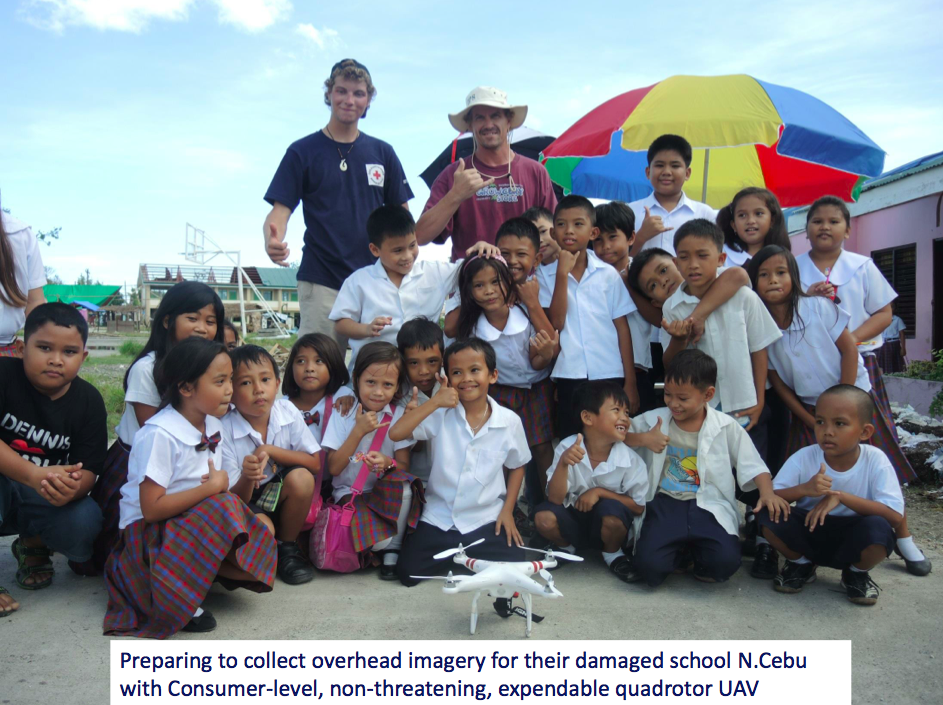
Credit: Cal State Long Beach – U Hawaii – Embry Riddle – Ateneo de Manila

So this all got me thinking: What if in the very near future, the user-generated content that gets shared during disasters were to also include aerial imagery captured by portable, micro-UAVs, from eyewitnesses on the ground? Could this then lead to an overflow of information that MicroMappers is perfectly designed to handle? Could we create a global network to connect all civilian/hobbyist UAV pilots to safely and proactively capture aerial imagery to support local and national humanitarian efforts? Could this same network build local capacity for locally deployed UAVs? And importantly, could such a global network also serve to facilitate coordination and set standards for operational safety and publish a Code of Conduct for the use of civilian UAVs in disaster response?

I don't have all the answers, which is why I launched the Humanitarian UAViators Network, to start connecting pilots and UAV enthusiasts so we can address these questions and challenges together as a community.

And what do you hope to achieve with this particular cause?

I want to connect new and experienced civilian/hobbyist UAV pilots from all around the world so that aerial imagery/footage can be quickly but safely captured following disasters, and shared (responsibly) with appropriate humanitarian organizations as well as affected communities. 

Newcomers to the UAV space may not be aware of the dangers and privacy issues that come with operating these flying robots, especially in humanitarian contexts. That's why I want to raise awareness now, connect these new pilots to a network that they can learn from and get guidance from--before big mistakes happen. That's also why I want to help establish standards and a Code of Conduct for both new and seasoned pilots.

For instance, there were a dozen or so UAV projects in the Philippines following Typhoon Yolanda but most did not know about each other or coordinate. Some operated at the national level, others at the grassroots level. At the very least, we should have a network for sharing information such as flight plans, which could facilitate coordination and avoid accidents.

I've drafted a Strategy Document (available here) for UAViators, and am actively soliciting feedback from hobbyists and humanitarian professionals alike. At the same time, I've launched this list-serve to start connecting UAV pilots/enthusiasts from around the world. My plan is to create a global directory of available pilots/enthusiasts and together with them create the framework we need to safely and legally generate & share volunteer-based aerial imagery during disasters. Of course, launching a network like this one raises more questions than answers, but I welcome the challenge and know that members of UAViators will be well placed to address them as a community.


What does the future hold for UAVs in humanitarian efforts?

Well, there are a lot of questions to answer vis-a-vis the present use of UAVs in humanitarian efforts. So we need to start with that. But in short, everything's going to be all automated very soon.

So I expect a lot of user-generated aerial imagery to be available during disasters in the future--mostly coming from non-professional pilots who own personal UAVs. This means we need to figure out the best framework to make use of this imagery for humanitarian response; and to do so in a way that is safe, legal and ethical, while respecting privacy, and serving the core humanitarian principle: Do No Harm.

Read more…
3D Robotics

3689581655?profile=original

In the past few years, over half of Indonesia’s rain forests—the world’s third largest—have been lost to logging and agribusiness. ConservationDrones member Keeyen Pang is doing something about it.

Pang, a tractor parts and service dealer for a local oil palm plantation in Sabah, Malaysia, has been flying RC planes and helicopters for more than twenty years (he also races 1/10 nitro touring cars). Spatial imaging had been growing more and more important to the oil palm business, but with piloted aircraft being prohibitively expensive, Pang searched the web for alternatives, where he discovered DIYDrones and ConservationDrones. Soon he’d joined the ConservationDrones Asia team, testing airframes and fine tuning systems to work with APM for research and other use.

Pang first visited Indonesia’s Sumatra rainforest, now a restoration project under national protection, with ConservationDrones co-founders Serge Wich and Lian Pin Khoo. The reserve area is too large to efficiently monitor from the ground (a few hundred thousand hectares), and helicopters and planes are too expensive. The bird’s-eye map and video they get from the IRIS (check out Pang’s review of the IRIS on DIY Drones here) offer a comprehensive understanding of the area surveyed. The group’s main objectives are to monitor and map the restoration area and to perform orangutan nest counts; if they fly with a GoPro at an altitude of about 100 meters, the high-resolution pictures are good enough for a trained eye to identify the nests.

Like all of us, his team could use more flight time. With a GoPro, an IRIS battery lasts 7-8 minutes, and it can cover a little over a mile. But for Pang,that means he can monitor 20 to 30 hectares of forest in less than 10 minutes. With five batteries, he says a pilot or forest manager can cover more than 100 hectares in under 2 hours with the IRIS. He adds that it may take weeks for multiple forest rangers to complete the same task on foot.

Pang chose IRIS because "it works right out of the box.” He uses mission planner for survey routes, and the vertical take-off and landing are especially useful in a tropical forest where it’s often tough to find a landing spot for planes or a fixed-wing drone. He says he’ll continue to fly regularly over the area and monitor changes over time. Drones also make it easy and safe to detect encroachment and illegal activity within the reserve, he added.

If you've got questions for Keeyen, or want to contribute or learn more, check out his DIYD blog.

Read more…
3D Robotics

Introducing 3DR's Aero Fixed-Wing

3689581211?profile=original

If you've been looking for an economical plane platform, that search ends here. The new RTF Aero fixed-wing provides at least 45 minutes of autonomous or RC-controlled flight, all housed in a robust, lightweight airframe.

Powered by Pixhawk, the Aero is capable of flying repeating missions with over 100 waypoints using a Mac, Linux or Droid device. The Aero is therefore ideal for capturing video over long distances, making it the perfect tool for autonomous missions. Partner with our FPV kit to get crisp, live-streaming video with superimposed telemetry data.

Priced at $1350, this aircraft is a serious tool that offers serious fun.

The Aero includes

  • Ready-to-fly 3DR Aero aircraft
  • Flight checklist
  • 4S 6000 mAh LiPo power pack and balance charger
  • 3DR Radio air and ground modules
  • Micro-USB ground station adapter

Specifications:

  • Pixhawk autopilot system
  • 3DR GPS+Compass
  • RC Tiger Motor 2820 830kv motor
  • RC Tiger Motor 60A ESC
  • External LED indicator and USB port
  • Digital airspeed sensor
  • Average flight time: 40 min
  • Payload capacity: 2kg
  • Wingspan: 1,880 mm
  • Maximum speed: 56 mph (90 kmh)
  • Minimum speed: 22 mph (35 kmh)
Read more…