sander's Posts (13)

Sort by
100KM

An In-depth Comparison Of Mapping Drones

When acquiring a mapping or surveying drone, the choice is quickly narrowed to a fixed-wing airplane combined with Vertical Takeoff and Landing (VTOL) for its vastly greater range, versatility and ease of use. Within this segment, there are several commercial-grade solutions of European origin. But comparing their capabilities and limitations can be difficult.

The following comparison was made to provide a detailed insight into the characteristics of the leading suppliers in this field. The data has been verified across multiple sources. Several aspects have been calculated to provide a consistent representation of the data. The calculation methods and sources are provided at the bottom of this article.

The platforms chosen for this comparison are:

  • The DeltaQuad Pro #MAP by Vertical Technologies
  • The WingtraOne by Wingtra
  • The Trinity F90+ by Quantum Systems
  • The Marlyn by AtmosUAV
  • The eBee X by SenseFly 

In this article, you will find an abstract of the comparison.
Click here to read the full comparison


Key Features

A quick rundown of the most critical aspects that are relevant to mapping.

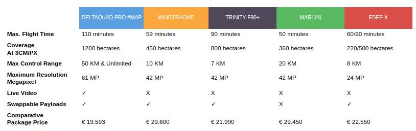
  • Max flight time is calculated at sea level with camera payload.
  • The coverage is calculated by multiplying the maximum flight distance by the maximum camera resolution. It is based on 3CM per pixel with an overlap of 50%.
  • To compare pricing a package was selected for each model that most closely resembles: 42MP camera, <1CM PPK, 2 Batteries, Standard radio, GCS (if available).


I7Pk5njH6FJe4FpJV5Wuti2qnmYXz4erpMIu3LeuuVZvA_4clCTqZvprnFWYT-eFT9vKo0dLPlJaL27JrgAIpnwGnHTk72tHOcB_38huIC9FYRf09Gx0RqHZ5u-ztQ4QsHwQGXEX

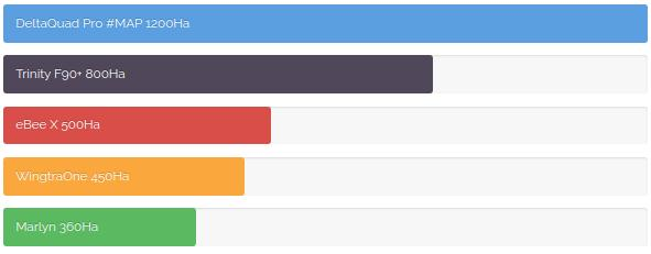
Maximum surveying area in Hectares

The maximum area that can be mapped in a single flight is determined by several factors such as camera resolution, cruise speed, endurance, and lens options.
This comparison is based on the highest resolution offered for each platform, combined with the maximum flight distance. The values have been calculated based on 3cm per pixel resolution and a 50% image overlap. The values have then been compensated to account for the camera’s minimum trigger interval.
 

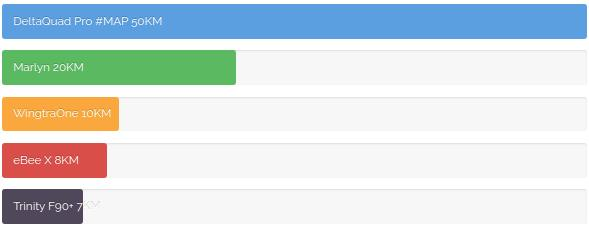
Maximum telemetry range

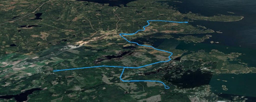
The maximum range at which the UAV can be controlled. Long-range communications is important for corridor-type surveys such as power lines, pipelines, railways, and roads.

The indicated ranges are the maximum radio range as specified by the supplier. Nominal ranges can be lower.


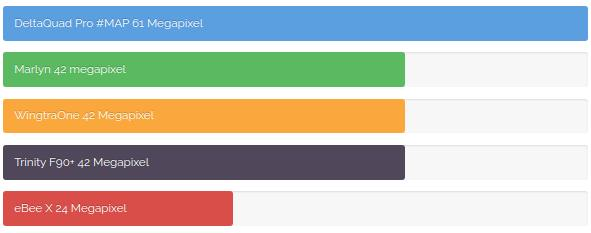
Maximum image resolution

The maximum image resolution in Megapixels is the total number of pixels that make up a single image. This can be an important factor for a fixed-wing/VTOL UAV.

A higher resolution allows:

  • Covering larger areas
  • Flying at higher altitudes
  • Producing higher resolution end results
  • Better post-processing performance with more accuracy
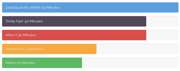
 

Maximum flight time

The maximum flight time for fixed-wing UAV depends on the altitude above sea level. As the altitude increases, the UAVs need to fly faster due to a lower air density. However, the lower air density also provides less drag, therefore in most cases, the maximum flight distance remains the same at all altitudes.


The indicated maximum flight times are at sea level while carrying a regular camera payload.


Read the full comparison

The full comparison contains detailed technical specifications, pricing details, sources, and methods of calculation.
Click here to read the full comparison

Read more…
100KM
BVLOS powerline inspection over a city using VTOL UAVs

Skyqraft, a data-driven infrastructure inspection company from Sweden, was granted BVLOS operation permission for the Vertical Technologies DeltaQuad VTOL UAV, to inspect a large portion of the Swedish power grid.

Fully Autonomous

Flying fully autonomous from takeoff to landing, using long-range radio transmission combined with LTE based video and control links, Skyqraft was able to perform multiple BVLOS missions gathering high-resolution images for over 1000KM of powerlines. The resulting data is used for early indicators of failures to the powerlines, isolators, and towers.

The missions are planned to follow the powerlines at a safe altitude using automatic terrain following. The onboard camera is automatically triggered to record high-resolution photographs of the selected path while the operator receives live video and keeps a control link over long distances. Using ADS-B transponder receivers the pilot is made aware of any aviation up to 100km away.

Beyond Visual Line Of Sight Waiver

A DeltaQuad Pro #MAP was initially trialed in Visual Line Of Sight (VLOS) and Extended Visual Line Of Sight (EVLOS). The success of these trials, combined with the advanced failsafe features and a redundant flight system, led the Swedish authorities to issue Skyqraft an additional waiver for the DeltaQuad to fly extended-range missions and to cross populated areas.

With the waiver secured, and after several BVLOS missions over scarcely populated areas, the DeltaQuad was instructed to perform 2 missions crossing the city of Gävle autonomously covering 90KM of powerlines. A significant step forward as this was the first official autonomous BVLOS flight of a fixed-wing UAV over a Swedish city.

To date, Skyqraft has logged over 30 flight-hours BVLOS and inspected more than a thousand kilometers of powerlines.

Machine Learning fault detection

Using the latest technologies in the field of machine learning, the resulting data sets are automatically analyzed and, faults to any of the core components are flagged for manual review.

Every confirmed fault is added to a daily report combined with imagery and exact geographic location. The reports are dispatched to the designated maintenance teams who in most cases can act within 24 hours of detection.

About Skyqraft

Skyqraft employs several UAV operators, AI programmers, and data analysts to provide powerline inspection. By closely collaborating with local authorities, airports, and energy companies they can efficiently gather high-quality data, and by using computer vision based machine learning algorithms they produce a reliable risk assessment that allows energy companies to stay ahead of impending grid failures.

“The DeltaQuad has enabled us to inspect areas that were virtually inaccessible using regular inspection drones. The advanced planning features allow us to create terrain-following missions in minutes, and even on our longest flights we use less than half of the available battery capacity. The Vertical Takeoff and Landing allows us to operate basically anywhere, and the long-range capabilities significantly reduce the time and effort required to collect the data we need.

Vertical Technologies has been a great partner supporting us in every aspect of our UAV operations. The DeltaQuad drones have been performing with such consistent stability and reliability that they are now the core platform in our operations.”

UMAR CHUGHTAI, CTO AND CO-FOUNDER OF SKYQRAFT

Skyqraft is currently extending its operations to the United States where they are in the process of receiving the first BVLOS waiver for a fixed-wing VTOL UAV from the FAA. For more information on Skyqraft please visit www.skyqraft.com.

About the DeltaQuad

The DeltaQuad is a fully autonomous fixed-wing UAV with Vertical Takeoff and Landing capabilities. It can travel up to 100KM in a single flight while carrying industrial-grade sensors such as 61MP camera systems, or dual infrared and RGB surveillance gimbals.

The DeltaQuad is produced by Vertical Technologies, a Netherlands based manufacturer of commercial-grade VTOL drones for Surveillance, Transport, Mapping, and Inspection. For more information on the DeltaQuad VTOL UAV please visit www.deltaquad.com.

Read more…
100KM

DeltaQuad first mapping VTOL with 61 Megapixel sensor

5334387861?profile=original

Vertical Technologies has successfully integrated the new Sony A7R mark IV on the DeltaQuad Pro #MAP VTOL UAV. This release marks the first VTOL mapping UAV that supports 61 megapixel mapping.

Earlier this year Sony announced the release of their highest resolution camera yet. the Sony Alpha 7R IV offers a full frame 61.0 MP back-illuminated Exmor R™ CMOS image sensor with latest-generation BIONZ X™ image processor

This camera system has now been integrated on the DeltaQuad Pro #MAP VTOL UAV. With this sensor the vehicle can produce imagery down to 0.4cm/px or cover up to 1200 hectares at 3cm/px in a single flight. A full coverage sheet is available here.

Vertical Technologies is a Netherlands based manufacturer of commercial grade VTOL drones for Surveillance, Transport, Mapping and Inspection. For more information please visit www.deltaquad.com.

Read more…
100KM

The problem with airspeed sensors

pitot-tube.jpeg?profile=RESIZE_710x

Airspeed sensors have been a major concern for both manned, and unmanned aviation alike. Yet almost every fixed wing or VTOL vehicle is dependent on it. So what is wrong with these sensors and why are they used?

How an airspeed sensor should work

A standard airspeed sensors consists of a pitot tube, a temperature sensor and 2 pressure sensors. The pitot tube has 2 ports (holes), one at the tip (like an injection needle) which is called the dynamic port, and one at the side which is called the static port. Each of these ports are connected to a pressure sensor. When the tube is pointing forward on a moving vehicle, it can measure the difference between the pressure from dynamic and static port. When factoring in the temperature it can estimate the current speed through air.

So whats the problem?

Over the years many problems have been identified with the use of airspeed sensors in both manned and unmanned vehicles. There is not one major problem so here is a list in random order;

For both manned and unmanned aviation

  • Icing: The same ice you see forming on the wings of an airplane can accumulate inside the tubes. When this happens the reading get unreliable or inconsistent at best.
  • Water: It might sound scary, but a few drops of rain inside the tube can cause the sensor to fail. The pitot tube holes are therefor made as small as possible.
  • Sand & dirt: Due to the small size of the holes sand or dirt can get lodged inside the tube rendering it useless.
  • Calibration: An airspeed sensors requires calibration before every flight. This is needed to account for the difference in readings the 2 pressure sensors will give. No 2 sensors will read exactly the same. The calibration is a snapshot that can be different from one moment to the next.
  • Drift: As the sensors are in operation they tend to drift due to temperature changes, how they drift is not always the same so it is hard to compensate for this.
  • Angle of attack: As you might imagine the system only works correctly if the sensor is pointing directly into the wind, but the pitch angle of any aircraft, especially unmanned, can change based on speed, air pressure, temperature or drag.

Specifically for unmanned vehicles

  • It’s fragile: The sensor needs to measure undisturbed air to work, and therefor needs to stick out in front of the UAV. The pitot tube is hollow and fragile and can easily break during transport or landing.
  • It needs special calibration: Not everyone is a UAV specialist, and properly calibrating an airspeed sensor takes a specialist. The board computer cannot tell if the calibration was done correctly, it just needs to assume it was.
  • Temperature drift: A UAV heats up as it flies. This means there is a drift in temperature that does not correlate to the air temperature. The board computer will try to compensate for a temperature that is not the actual air temperature.
  • Cross wind: Where manned aircraft usually have multiple airspeed sensors, UAVs normally have only one. If it flies in a cross wind there will be extra pressure measured on the static port (on the side).

The effect of incorrect airspeed readings

If the airspeed data is missing most vehicles UAVs will not takeoff or enter some failsafe mode. But usually the data is not missing, it is simply incorrect. With incorrect readings it will either fly too fast and therefor very inefficient, or it will fly too slow and in many cases crash.

Another serious side effect of bad airspeed readings is landing. Fixed wing UAVs are generally loaded to their maximum capacity. That means they need to fly their absolute minimum speed to land without damage. If they land too fast they start tumbling and usually break their wings or worse. VTOL fixed wing UAVs do not have this problem, but still suffer from inefficient or dangerous flight behavior when the readings are incorrect.

Eliminating the danger

During the research & development of the DeltaQuad VTOL UAV it quickly became clear that the airspeed sensor was a major concern. We therefor embarked on achieving the impossible: completely eliminate the danger.

Having members on the PX4 core development team can be a big advantage when pioneering in unmanned aviation. Using this advantage we managed to completely eliminate the need for an airspeed sensor by using a variety of other sensors to estimate our airspeed accurately and consistently.

Achieving accurate and reliable estimation was not easy, and required very specific tuning and testing, but the end result turned out better then we hoped. Using our estimated readings we not only eliminated all the issues in relation to airspeed sensors, we had also increased the efficiency of our vehicle by 20%

So if you are considering the purchase of a fixed wing or VTOL UAV, and you see a probe sticking out in front that look suspiciously like an airspeed sensor, make sure you think twice.

Read more…
100KM

3689738862?profile=original

Vertical Technologies launches the DeltaQuad Pro #INSPECT

To meet the growing demand for dedicated solutions in a wide range of drone enabled inspection tasks, Vertical Technologies have expanded their autonomous DeltaQuad Pro VTOL range with the DeltaQuad Pro #INSPECT.

The DeltaQuad Pro #INSPECT exceeds all the specifications required for actionable inspection flights and is available with a downward facing camera sensor that records video with embedded GPS coordinates. The vehicle is designed to accommodate the Flir Duo Pro R Dual Thermal & RGB sensor, or the MapIR Survey3 RGB sensor.

The DeltaQuad Pro #INSPECT can cover up to 150KM in a single flight, has been equipped for fully autonomous flight along a planned path and is easy to control. It can be used for a wide range of inspection tasks including;

✔ Powerline inspection
✔ Pipeline monitoring
✔ Vegetation control
✔ Wildlife monitoring
✔ Disaster area reconnaissance
✔ Rail & Road monitoring

As a member of the DeltaQuad family the DeltaQuad Pro #INSPECT provides all the features that make the DeltaQuad series among the most versatile and easy to use commercial VTOL UAVs on the market.

Vertical Technologies is a Netherlands based manufacturer of commercial grade VTOL drones for Surveillance, Transport, Mapping and Inspection. For more information please visit www.deltaquad.com.

Read more…
100KM

At the end of this new DeltaQuad compilation video, you can see the 3D rendering that was created from a survey mission of a dutch peninsula. The mission was flown using a DeltaQuad Pro #MAP carrying a Sony A7R3 with a 35mm lens. Using Pix4D the data was processed and a 3D map of the island was rendered.

The company responsible for monitoring the island had previously used a DJI Inspire which required 18 batteries and 2 days of non-stop mapping. After switching to the DeltaQuad they were able to map the entire island in a single flight with no more then 60% battery consumption. The increased stability and high resolution camera payload produced significantly better quality images.

Make sure you watch the video to high resolution and skip to 3:16 to see the results.

Read more…
100KM

3689735374?profile=original

After the successful launch of the DeltaQuad Pro, and DeltaQuad Pro #MAP, Vertical Technologies has now launched the DeltaQuad Pro #VIEW; A long range surveillance drone based on the DeltaQuad hybrid VTOL fixed wing UAV.

The DeltaQuad Pro #VIEW offers all the advantages of the DeltaQuad Pro and is equipped with a high grade surveillance camera. The available surveillance packages range from entry-level nose cameras to state of the art computer guided thermal & RGB controllable gimbals. Every package is accompanied by a carefully selected video transmission system for optimal quality and range. 

This newest addition to our range of DeltaQuad models has been developed and tested for more then 6 months and is currently in active duty with several launching customers. The 3 surveillance payloads to choose from range from simple static SD video to full HD 30km range dual thermal & RGB camera gimbals with object tracking and automatic retracting. 

Check out all the specs and options at deltaquad.com/view

Read more…
100KM

3689715147?profile=original

This Saturday at DronesLab we achieved an important milestone in the final steps towards the public release of the DeltaQuad: A 100KM autonomous mission carrying a 1KG payload. This marks the achievement of the most important goal we have set when we started the development of this vehicle over a year ago.

The DeltaQuad is an electric VTOL flying wing capable of fully autonomous operation. It is driven by either the PX4 or AirRails flightstack in combination with proprietary safety and performance software. It is controlled through a tablet and streams telemetry (and optionally video) over an encrypted VPN using the cellular network. Most notably it flies without the need for an airspeed sensor. This improves reliability, usability and performance.

After extensive testing and hundreds of flight hours we knew it could achieve this goal in theory. But as with any theory it needed to withstand the test of reality. So we we started preparing for a mission that would do just that.

The mission

3689715165?profile=originalThe mission was flown in a square pattern. It was setup to autonomously take off vertically to an altitude of 22m, complete 20 laps on a 5km circuit at an altitude of 30m, and land vertically near it's takeoff point. It cruised at approximately 15m/s. The mission took 1 hour and 50 minutes to complete. It was outfitted with a 23Ah 4s lipo and consumed 20.7A of which 19.3 was used for fixed wing flight and 1.4 for vertical takeoff and land.

The payload consisted of a 1KG box filled with dummy weight. The total distance was confirmed through a KML export of the mission loaded in google earth as you can see in the image above. 

The full log of the mission can be found here: http://logs.uaventure.com/view/QEofXUiC5dwm9zh7B3vXgk

Whats next

The DeltaQuad will be publicly available this summer under a new label that we will soon announce together with the full specs and pricing. Additional options and modules will be released shortly after that. Although we can not yet release any more details we are confident that it will be one of the most reliable, scalable and affordable VTOL UAV's that is suitable for commercial applications.

** Update **

The DeltaQuad has been publicly released. Visit https://www.verticaltechnologies.com to find out all the details.

Read more…
100KM

3689719760?profile=original

Vertical Technologies has released their DeltaQuad series of autonomous VTOL UAVs. This hybrid vertical takeoff fixed wing vehicle can stream telemetry and video over the cellular network using VPN, and boasts an impressive 1 Kg payload capacity, 2 hour 45 minute flight time and 150 Km range.

The DeltaQuad is developed by members of the PX4 Pro autopilot development team and uses several impressive features that make this UAV as easy to control as setting up a navigation system. It requires no pre-flight calibrations and the Pro model comes equipped with an onboard computer that almost completely replaces the operator. This makes the vehicle suitable for BVLOS missions. The included DeltaQuad simulator makes it easy to get familiar with the controls and allows test flying missions before they are executed.

The DeltaQuad is aimed at the professional market and has been priced very competitively. It is built with industrial quality hardware and many electrical components are specifically designed for the DeltaQuad.


It comes in 3 different varieties: the DeltaQuad Base, One and Pro. The DeltaQuad Base is a kit version intended to be outfitted with aftermarket avionics. The DeltaQuad One is the RTF version. The DeltaQuad Pro comes with 4G VPN secured telemetry and video, and is equipped with an additional board computer running the DeltaQuad Safety and Performance System for advanced autonomous capabilities. These advanced features include weather condition checking, mission and terrain validation and air traffic awareness using ADS-B.


Vertical Technologies, a company started by the people from DronesLab, has been working on the DeltaQuad in relative secrecy for more than 14 months. Today they open their doors on https://www.verticaltechnologies.com and are ready to ship DeltaQuads world-wide.


Read more…
100KM

Scam warning: NEMORC.COM and DRONADA.COM

To anyone considering a purchase from nemorc.com or dronada.com i would like to warn you of the following.

The store is owned by Phillippe Cosyn from Moldova, someone who is known to scam and has previously done so under the name RCMOLD-STORE.COM. (https://www.rcgroups.com/forums/showthread.php?1680460-RCMOLD-store)

He now operates under nemorc.com.

After transferring funds to him he stopped all communication. It was only later that i found out he is known to scam the RC community with other store names.

I hope this warning will save others from losing their hard earned money.

Read more…
100KM

Autonomous 60KM flight of the DeltaQuad VTOL

We are currently on the 5th prototype of the DeltaQuad VTOL and today we have put it through its paces with a 60KM autonomous flight. Over at DronesLab we have been working on this machine for more than a year and are in the final stages before releasing it to market. Above is a sneak preview.

The 60KM flight was planned after settling on the final specs of the fixed wing drive. After this flight the battery had only discharged 65% of it's total capacity. This puts the range of the DeltaQuad on our 100KM goal. 

The log of this flight can be found here: http://logs.uaventure.com/view/LDwQsdRc3LpVwrd7EsenR8

We have always been careful with releasing specs as we did not want to over promise anything, but after many inquiries here's a small overview of the current specs;

Cruise speed: 60kph
All out weight: 5.2KG
MTOW: +- 6.5KG
Wing span: 2370mm
Range: 100KM (carrying 1KG payload)

These specs are not final and more tuning will be done to maximize reliability and efficiency.

Uniquely on this airframe the payload bay is located directly on the CG, it can therefor fly with dynamic payload weights without needing to balance the CG. We have also successfully managed to eliminate the requirement for an airspeed sensor (no more daily calibrating required).

It is designed to be controlled from a tablet or cloud system and flies fully autonomous from takeoff to landing.

As with any R&D project it is hard to give timelines but the DeltaQuad should be available in both hobby and commercial versions mid 2017.

Cheers,
DronesLab

Read more…
100KM

The second prototype of the DeltaQuad was given to the PX4 team at ETH in Zurich. The DeltaQuad is a VTOL flying wing based on the Skywalker X8. It is currently under development at DronesLab and will be available soon.

The PX4 team has added the airframe to the Gazebo simulator and made this impressive video

The modifications made to the airframe put the CG exactly in the middle of the large payload area. That makes it very useful for cargo transport, arial mapping and other payload dependent tasks.

At DronesLab we're working hard towards a stable platform ready for production. The current prototypes are being tested for accurate performance, endurance and capacity statistics. The next prototypes will be equipped with custom wing joiners that house integrated connectors for fast assembly.

Stay tuned for more updates

Read more…
100KM

DeltaQuad VTOL autonomous maiden flight

After some succes with the QuadRanger we developed we decided to step it up and convert this Skywalker X8 to VTOL. And this was it's maiden (autonomous) flight

It was outfitted with the PX4 flightstack too which I recently added the VTOL_TAKEOFF and VTOL_LAND support.

The maiden flight of the DeltaQuad was a succes. It slightly overshot it's landing site due to a miscalibration of the airspeed sensor (it was flying faster then measured). Still it made for a very smooth flight.

In the next few weeks we will start payload and endurance testing, based on the current data it looks like it could carry a 1-2 kg payload for a distance of around 80km.

The build serves as a prototype for the modules/platforms that we (DronesLab) aim to produce and make available this year. 

I'm very interested in your thoughts, idea's and comments so feel free to drop a line! 

Read more…