27th June 2010 - 3D Telemetry using Google Earth - Just like a sim but for real!
Due for release shortly includes: Adding your own google sketch up models, equipment/models database, maxpilot,mega, kml, logging, sharing of config and kml/model information
Next job prior to release to make a HUD/OSD instead of the solid instruments displayed below.
Currently I am adding support for a serial camera. The serial camera is a simpler device than real video but works quite well. The Kml output will also include an option to show images for any part of the journey
release later in year to include two way telemetry.
the existing functionality mentioned below will remain valid, using google earth sim is optional
Project renamed to "ArduFab" (Beta)
15th June 2010 - FAB 1.2 Flight Computer Version 1
14th June Update - here
Please do not use for actual flight. This is beta and not fully working or tested!
For all those who tried the earlier version .. "I've refreshed the msi it wasn't setup correctly sorry"
Thanks to so many contributors for putting their projects on the web. I've used many people code!
What is working
Entering a com port, setting a baud and clicking the "ON" button will read ardupilot telemetry
The instruments that appear when you switch “on” will show values
The Log will show you raw data from the ArduPilot.
The log will can also show Attitude and Position
The H marker on the map shows where the ardupilot currently is (In progress!)
(There is a large delay before the map shows the correct information. To be fixed)
If the telemetry is switched on before the ArduPilot is started then the map shows the waypoints
Only web links work in the tree
The summary is very basic at the moment and only applies if a full start up has been
What isn’t working
Quite a bit!
The radio window only shows throttle, might show battery but not tested
The radio window can’t be resized correctly
The map shows your waypoints but needs much more work
Access to configuration tool and code editor
Saving of journeys
Saving of configurations
Direct IMU telemetry is implemented but held back for testing
Waypoints checkbox on the log
All menu items and tool bar buttons
Map reset
Zero altitude
Two way com
Diagnostics and additional instrument controls
Flight Computer
Set home via map
Clear map / reset map
Adding properties such as ardupilot source path
Video
Additional sets of indicators + night/day mode effects
Replay journey
Lots of config options
Visible and audible alarms
History______________________________
This was the original project that I found on the internet that got me thinking about a windows ground station.
The brilliant ArduPilot ground station prompted me to look for a solution because it is difficult for me to have labview installed on my machine. Doesn't comply with our software audit and besides that I am not happy about the price of labview.
I like arduino and the microsoft micro framework, the two products seem to have their places in this world. As such I decided to see if the Micro framework could provide a 3/5 volt mini ground station.
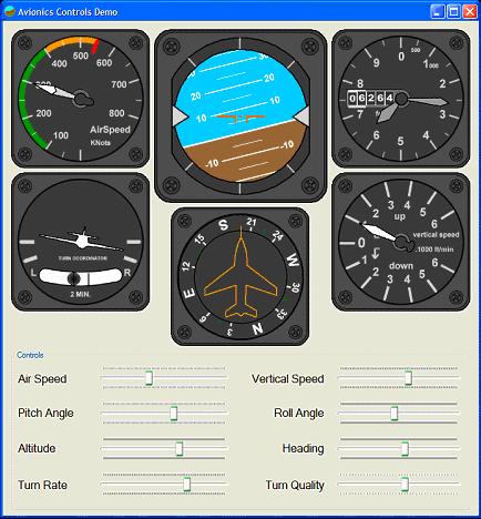
My project has developed since I found these controls but I include a link because the maths in this project makes creating scalable/resizable moving controls very simple.
http://www.codeproject.com/KB/miscctrl/Avionic_Instruments.aspx
GroundStationT
My ground station project is now working with text based imu output or with the ardupilot. The instrument controls are now single widget windows that can be re-positioned and resized independantly.
The main control is the attitude indicator control. When it is moved all other control move with it. The mouse wheel is used to increase/decrease the size of an instrument.
The application has a main frame but the instrument controls are displayed outside of the main frame. Yhis allows the frame to be minimized and the instruments to occupy the entire screen.
The view menu currently has a google map showing current position and next waypoint, current work is to enable the map to be displayed in place of the ground (below the sky) in the attitude indicator and to allow more transparency of other instruments.
The google map link is going to be interesting to develop alonside a Telit GSm module that I have. By the google code initially came from the ArduPilot config tool, so hats off to the clever ground station pair!
I initially coded the processing of serial telemetry and the instrument controls using the micro frame and a tahoe II board. This proved the project would work and once the various instrument controls are working with proven tested values, I indend to convert the project back to the micro framework.
The current windows project can be found here but it is untested in the field and should not be used for actual flight monitoring. The current project is just a .exe, it requires microsoft windows framework 3.5 and will fail to run if you don't have it installed.
FYI: Current cores (board support) provided by MF4 are as follows but you can also build your own using the free porting kit!
ARM v4,
· ARM Thumb
· Thumb-2
· Blackfin
Development Boards
The porting kit provides sample ports available for the development boards listed below. These sample ports include the source code.
- Atmel SAM9261-EK development board (ARM core AT91SAM9261)
- Atmel SAM9RL64-EK development board (ARM core AT91SAMRL64)
- Atmel SAM7X-EK development board (ARM core AT91SAM7X512)
- Phytec phyCORE-ARM7/LPC2294 (Rapid Development Kit PCM023, ARM core LPC2294 by NXP)
- Embedded Artists EA-LPC2478 development board (ARM LPC2478 by NXP)
- Crossbow MOTE2 platform from Crossbow (for Marvell PXA271 processor)
- Freescale i.MXS development kit (Freescale MC9328MXS)board for i.MXS processor
Memory Requirements
The memory requirements for the .NET Micro Framework depend entirely on which features you use. In its smallest form, the framework requires 64 Kb of RAM and 256 Kb of flash memory.

Comments
And gps telementry means the gps data?can we have two connections from the o/p of the gps one to the imu and other to RF module,or before sendind it to trnsmitter we need to convert the gps data to perticular format.
hope these questions donot iritate u.
Fraser Williams has written some semi-useful google code articles for earth, most people are moving to the earth plugin which has much more functionality but does not have off-line capability that the windows google GE interface (EarthLib.dll) provides.
The serial protol is easy to work with in c# if you loop through each LINE of the serial and use the string.split() for , and :
!!!LAT:334343434,LON:675677657,***
Remove the !!! check for the ,*** and you have a valid serial line
Split on comma gives
LAT:23424234
LON:345353
Split on : gives
String[0]=LON
String[1]=23424234
Serial Port Access
using System.IO;
using System.IO.Ports;
SerialPort serPort;
serPort.PortName = portName;
serPort.BaudRate = Convert.ToInt32(bitRate);
serPort.DataReceived += new SerialDataReceivedEventHandler(port_DataReceived);
serPort.Open();
To see how to read the telemetry values, which in most cases need to be /1xxxx to give decimals, look at the ArduStation Arduino code.
There are lots of serial examples on the web. The ArduPilot config tool also uses serial and I think the source code is published
May i know, are you using C# to do your groundstation?
I do not know about earth tracker but i assume it will only read the gps if the gps is plugged directly into your pc
Have you looked at the software tools available via the diy drones wikki?
Maybe you should explain what hardware you have and what you want to do otherwise your questions are very diverse
If that doesn't help then email me your project an d I will add them and send it back to you
Many Thanks
Nick
-
2
-
3
-
4
-
5
-
6
of 10 Next