drone (33)
Introducing CopterPack - a carbon fiber electric backpack helicopter. First flight video is coming soon!
Enterprises & Startups can leverage FlytNow APIs to build & scale automated, cloud-connected drone applications, and reduce time-to-market.
The commercial drone industry is heading towards complete automation. This transition calls for seamless integration with different software & hardware. At FlytBase, we are cognizant of this ever-growing need for scalable enterprise applications that involve drones. Keeping this in focus, we are introducing FlytNow API platform to enable automated, cloud-connected drones applications for enterprises & startups.

We are proud to announce that we are extending the capabilities of FlytNow as a comprehensive backend platform for enterprise drone ops. We introduce FlytNow APIs to securely connect drones with any type of business application that supports RESTful architecture. This means that businesses can rapidly build and scale custom drone applications to manage their drone fleet.
Key benefits of using FlytNow APIs
- Simple: FlytNow APIs are simple with clearly defined endpoints to perform specific functions.
- Powerful Abstractions: FlytNow APIs provide powerful abstractions so developers do not have to deal with lower-level languages to communicate with drones.
- Hardware Agnostic: Whether it is a DJI, PX4, or ArduPilot drone or any companion computer (like Rasberry Pi 4b, Nvidia Jetson, ODROID N2, etc.), FlytNow APIs are agnostic and have the necessary adapters to communicate with the hardware. These APIs
- Discoverable: Our API endpoints are logically organized in extensive documentation so that even new developers can get up to speed quickly with the capabilities.
- Consistent: All our API endpoints are constructed logically so that developers can anticipate different functionalities.
- Virtual Drones: As the name implies, these are simulated drones in a virtual environment. Work on simulations to test your applications faster without risking expensive hardware.
- Scalability: Our cloud services are hosted on Amazon AWS, and it is adaptive making it possible to deploy resources as you grow your business.
APIs that are currently available for our enterprise users

- Navigation APIs: Control drones remotely from a dashboard.
- Telemetry APIs: Fetch telemetry data like speed, altitude, global position, etc. from a drone.
- Payload APIs: Control & integrate various payloads with FlytNow.
- Video Streaming APIs: Access live video streaming from a drone. Share this stream with your team and guests for collaboration.
- Vehicle Setup APIs: Perform a series of checks on the operational capabilities of a drone.
- Gimbal Control APIs: Remotely control the gimbal pitch of a drone.
- Camera Zoom APIs: Change the orientation of the camera and the zoom remotely.
- Command & Control APIs: Send drone to a GPS location, control heading remotely.
- Mission Planning APIs: Set a pre-programmed mission/path for a drone.
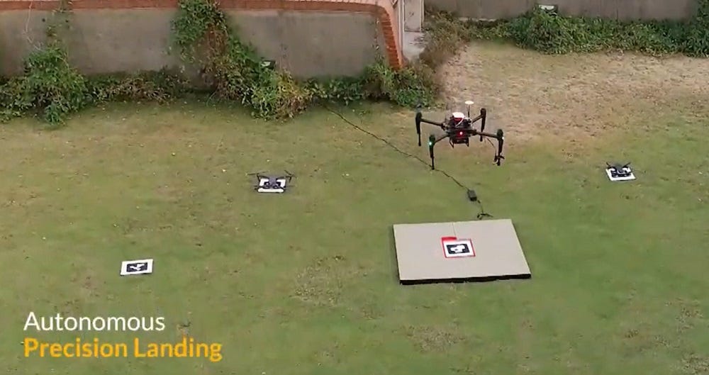
- Precision Landing APIs: Land drones precisely on a machine-generated tag.
- Collision Avoidance APIs: Integrate collision sensor data with FlytNow dashboard and set thresholds to avoid collisions.
- Drone-in-a-box API: Integrate with Drone-in-a-Box hardware. Command drone launches and landings remotely. Moreover, you can retrieve charging (or battery swapping) & docking station statuses.
- Geofence APIs: Set a virtual boundary for drones and trigger fail-safes in case of breaches.
What enterprises & startups can build using our Drone APIs
Drone-based autonomous security and surveillance system:
Security systems can be enhanced using drones. A custom enterprise web application can be integrated with CCTV cameras & software (for example Video Management solutions like Milestone), motion sensors, and ground-based hardware using FlytNow APIs. Further, businesses can leverage these APIs for mission planning to automate the patrolling of drones, thereby reducing the need for redundant manpower. Automation need not be limited to just spontaneous patrolling; it can be scheduled for regular security patrols using APIs for DiaB (Drone-in-a-Box hardware). Absolute autonomy lies in eliminating human interference starting from time-defined missions where the drone takes off, performs the mission, and docks back into the box to charge/swap batteries. In real-life, the system will leverage a unified dashboard as a command center and our live video streaming APIs to manage the entire operation. In the event of an intrusion, it will operate in the following way:

- An intrusion alert goes off in the main dashboard. API integration with FlytNow triggers the drone system.
- The system creates a waypoint mission for the drone. A drone automatically launches from a DiaB station and goes to the point of interest.
- The drone begins live-streaming, and the human operator identifies the intruder from the live drone footage. The operator uses the payload APIs of FlytNow to maneuver the camera and look around. AI-detection technology can also automate intruders and help track in the video.
- On completion of the mission, the drone automatically returns back to the docking station.
Drones-based medical delivery system:
Companies have been actively building & deploying drone systems that can deliver critical medical payloads to remote locations. A US-based company called Zipline is one such company that has extensive operations in the African nations of Ghana and Rwanda. They rely on a centralized system where they operate from a medical warehouse and all incoming requests for blood are fulfilled via drone delivery. The highlights of the system are that the drones can fly autonomously from the warehouse to the delivery point, drop the payload, and return back to the base. Following are some APIs of FlytNow can be used to build a similar system:

- Mission Planning APIs: To set the route of a drone to the delivery location.
- Navigation APIs: To take control of a delivery drone remotely in case of an emergency.
- Vehicle Setup APIs: To run a diagnostic of a drone before sending it off to a mission.
- Video Streaming APIs: To remotely monitor a delivery mission through a video feed.
- Geofence APIs: To restrict the area of operation of the drones.
- Command & Control APIs: Send drone to a GPS location, control heading remotely.
- Collision Avoidance APIs: To get data from the onboard sensors and set thresholds to avoid collisions.
- Payload API: To control the payload dripper or actuators
Drone-based emergency response system:
Leveraging the FlytNow APIs, a response system can be built that is fully autonomous and integrated with a Computer Aided Dispatch system like 911. In the event of an emergency, an operator using such a system can dispatch a drone to survey the situation. On receiving the command, a drone will launch and fly to the location autonomously and begin acquiring data using its onboard camera. The operator can share the live feed of the drone with the first responders who can plan a better response.

The APIs used in this case would be similar to the delivery system mentioned above, with a focus on BVLOS capabilities and live-stream of data.
Summary
In this blog, we introduced the APIs of the FlytNow platform and the benefits of using them. In a nutshell, FlytNow is built for developers building applications to manage enterprise drone operations with BVLOS capabilities. Our extensive and reliable set of APIs is a result of our experience working with commercial drones for almost a decade. Originally published on FlytNow
If you are looking for the hardware to diy a drone by your own?
If you find it's hard to get the drone parts with competitive cost?
If you are looking for a drone with light weight and long endurance?
T-Drones is here happy to offer the solutions.
T-Drones M690A 0.5-1kg payload, 60-70mins flight time by battery;
T-Drones M690B 1-2kg payload, 50-60mins flight time
T-Drones M690 folding version , 350*320*130mm size to take away.
Any query:
Email: t-drones@outlook.com
What's app:+ 86 15070853230
 Commercial drones are now becoming a mainstream technology, with the 2020 pandemic serving as a showcase for how drones can save human lives.
Drones have been used for delivery long before Amazon announced its Prime Air service. Founded in 2011, Zipline, a US-based company focused on medical drone deliveries became the pioneer in long-distance drone delivery, with distribution centers in Rwanda and Ghana. With an exponential growth since then, Zipline now delivers 65% of blood samples in Rwanda, particularly because the country lacks suitable road connectivity.
Companies like Zipline are investing heavily not only in better drone hardware but also in remote operations software, so they can intelligently & centrally manage a large fleet of drones.
How Does Drone Delivery Work?
Drone delivery refers to the act of moving a package from point A to B using unmanned aerial vehicles (UAVs). Such UAVs are either autonomous or remotely controlled by human pilots.
The infrastructure that powers drone delivery operations requires seamless integration between reliable drone hardware and robust software that can enable EVLOS/BVLOS Operations. The components of such systems include:
Drone Hardware
Drones that are capable of carrying heavy payloads; for example:

Links to above-mentioned drone specs:
- DJI M600 Pro
- DJI M210 V2
- [New]DJI M300 RTK
- GAIA 160MP-Heavy Lift Drone
- D130 X8 Titan Version Combo
- FOXTECH Great Shark 330 VTOL
- IMPOSSIBLE AREOSPACE US-1 Performance Aircraft
Companies like Zipline, Wing, etc., have their own fleet of drones specifically designed and developed to suit their specific delivery needs.
Note:
- The above specifications are as given on the DJI and Foxtech website.
- FlytNow is compatible with all DJI, Ardupilot, and PX4 based drones and provides software modules for EVLOS/BVLOS operation over 4G/LTE, 5G, Long-range RF.
Drone Fleet Management Software

Drone delivery requires an advanced fleet management software like FlytNow that helps plan & execute long-range EVLOS/BVLOS flights with live tracking and drone control over 4G/LTE/5G.
FlytNow Delivery is a cloud-based offering that can be used for package delivery operations. Delivery businesses can use off-the-shelf or custom drones to quickly set up a delivery system in their geography. FlytNow solution cuts the deployment time to a few days and gives a unified web-based dashboard to control and manage every aspect of a drone delivery operation. FlytNow Delivery Offers:
- Operator Dashboard - Centralized web-interface to manage all logistics operations
- Dispatcher Dashboards - Web interface for store-fronts/medical centers to create delivery requests and live tracking.
- Recipient Dashboard - Web and mobile interface to live track drone location and delivery status
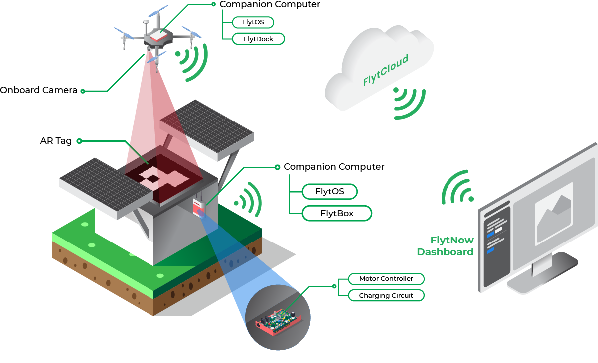
Onboard Drone Software:
A drone equipped with intelligent onboard software make this kind of operation autonomous and safe. With the integration of FlytOS intelligent modules and sensors with onboard SBC (Nvidia Jetson Nano, DJI Manifold 2, Raspberry Pi 3B+/4), drones can do:
- Autonomous Precision Landing or Hover (see FlytDock)
- Collision Avoidance (see FlytCAS)
- Electro-mechanical gripper control for package pick and drop
- Electro-mechanical pulley control for releasing a package from a height.
Drone-in-a-Box (DiaB) Hardware:
For operations to be autonomous and efficient -- physical, on-ground components such as a docking station, charging pad, launching systems, etc. are required. With FlytNow DiaB integration enables remote control & telemetry in the same delivery interface. Our enterprise solution also offers integration with DiaB APIs. Below are a few DiaB and charging pad solutions for reference:
- Airscort https://www.airscort.me/
- Skysense (https://www.skysense.co)
- WiPo Wireless Solution (https://www.wipo-wirelesspower.com/)
- WiBotic (https://www.wibotic.com/)
UTM Integration:
Airspace intelligence and management is a critical enabler for scalable, safe, beyond-visual-line-of-sight (BVLOS) or extended-visual-line-of-sight (EVLOS) enterprise drone programs. Such integration with a UTM engine or national airspace services can augment sense-and-avoid capabilities with regards to airspace, flying advisories, and weather information for optimal path planning while avoiding no-fly zones and manned aircraft. Some leading UTM and providers are:
- Airmap
- Attitude Angel
- Unifly
- Airpalette
- DigitalSky (for India)
Learn about the FlytBase partnership with AirMap here
FlytNow can be integrated with any 3rd party private or government UTM API services.
Advanced Fail-safes:
Whether you are flying in rural or suburban areas, the safety of people on the ground and expensive drone equipment is of utmost importance. Emergency situations like flight system failure, bad weather conditions, or immediate advisory from the local aviation authorities may happen anytime.
In addition to standard drone fail-safes (RTH, Geofence, etc.), FlytNow provides Emergency Landing Point (ELP) Failsafes. ELP Failsafes allow you to define landing points along your delivery route and land the drone on the nearest ELP when a situation arises.
FlytNow also provides advanced geofence features to draw a polygon on a map along the delivery route to restrict drones from going outside the designated area.
In unavoidable situations, a safety parachute on the drone can avoid accidents. Here are some of the brands which offer drone safety parachutes:
- Indemis
- ParaZero
- VectorSave
Use FlytNow to Quickly Demo Your Drone Delivery Operation
FlytNow Pro is a cloud-based SaaS solution, well suited to help drone operators and service providers quickly set up a PoC (proof-of-concept) delivery system to validate a proposed delivery plan or to manage customer demos.
If you are someone who is looking to quickly validate a delivery idea then FlytNow Pro is a good starting point. As more requirements get identified, customers can then migrate to FlytNow Enterprise for Drone Delivery, which offers an end-to-end software suite with advanced capabilities and priority support.
Getting Started with FlytNow Pro for Drone Delivery PoC
Step 1: Sign up for a 28 days free FlytNow Pro account.
First signup to our free 28 days trial by visiting: https://my.flytbase.com/accounts/signup/?next=https://app.flytnow.com

Open your email and verify it before you can access the dashboard. Login to your account using your credentials.
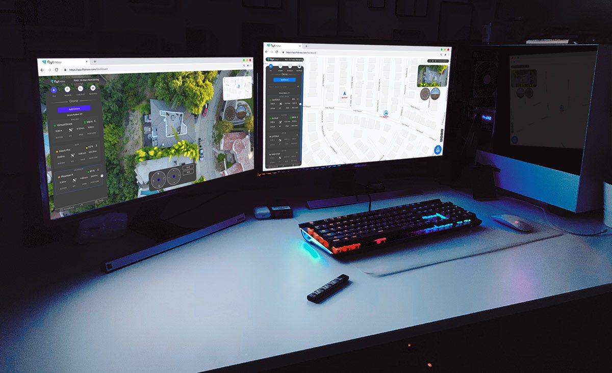
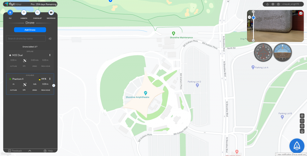
On the dashboard, you can add drones, create a flight mission, set up a pre-flight checklist, and define a geofence.

In the above screenshot, We have already added our drones and two of them are online. In your case, you have to add the drones. Follow our getting started guide to add your DJI drones.
Do not have a drone? Try FlytNow Pro with Virtual Drone. Follow Step 2
(Optional) Step 2: Adding a virtual drone.
Your free trial account supports up to five drones. In case you don’t have a drone, you can also add a virtual drone, you can add one virtual drone. For a virtual drone, you need to set up your FlytBase cloud APIs. Please follow this guide.

Once granted access to the cloud, you can use your virtual drone’s vehicle ID and token to add it to the FlytNow dashboard.
Step 3: Creating a Mission Plan.
A mission plan lets you add a route for your drone. Considering you are testing a medical delivery system, you use the mission plan to define routes to all the medical centers you want to make deliveries.
To add a mission plan, click on Mission -> Add Mission. Give a name to your mission and click on Add Waypoints to begin defining your route. Clicking on the map will place a pin; this way you can place multiple pins.

In the above screenshot, we have defined a mission that tells a drone how to go to Palo Alto Health Care. Apart from defining a route, you can set the flight speed and a Finish Action. The Finish Action tells a drone what to do once it reaches the destination; you can set the following actions.
- Hover
- Land
- Return to Home
In our case, we have selected Return to Home that signifies that the drone will drop the payload and return to base.
Please note that FlytNow Pro offers limited features for mission planning. Advanced features are available in FlytNow Enterprise for Delivery.
Step 4: Creating a pre-flight checklist.
This feature allows you to create a pre-flight checklist. In the case of a delivery operation, a checklist will ensure that a drone is configured properly before it is sent out on a mission.
To create a checklist, click on CHECKLIST and then Add to Checklist to add a checklist item. While adding a checklist item, you can also add a description.


We have created a checklist suited for drone delivery operations. You can create your own checklist.
Step 5: Setting up a geofence
A geofence allows you to set up a boundary for your operations. Once you set a boundary, FlytNow will not allow your drones to fly beyond the boundary.
You can set up a geofence by:
- Going to the GEOFENCE section in the FlytNow dashboard where you should be able to see your drones as a list.
- Click on the edit option available in front of your drone name.
- Enable the Geofence radius by clicking on the button.
- Set the Geofence Values as per your safety requirements, i.e Height, and Radius.
- The Height is restricted to 500 meters and radius is restricted to 8000 meters.
- Click on the Save button after entering the values.
The following image shows you how your dashboard will look after geofence is set successfully.

A geofence has two circles. The area between the circles is called a warning zone. Whenever a drone crosses the first circle, the system gives out a warning, but it will not let the drone go beyond the second circle.
While planning a mission, you can’t put a waypoint beyond the first circle.
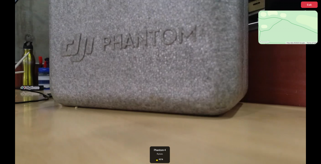
Step 6: Turn on Live video feed (feature works with a real drone only).
You can access the video feed of a drone from the dashboard. This feature is useful when a drone is out for delivery. This way you can visually assess a flight mission.
Select a drone under the FLY tab. Now you can see the video feed on the top right corner.

You can also enable the multi-cam mode (refer to the above picture) that will allow you to view the video feed from all drones on a single screen.

Step 7: Share live drone location and video feed with a third party (feature works with a real drone only).
You can share live drone locations and video streams with anyone outside the FlytNow platform. This feature is useful especially when you want to share tracking information with a recipient which might include live video feed from the drone.
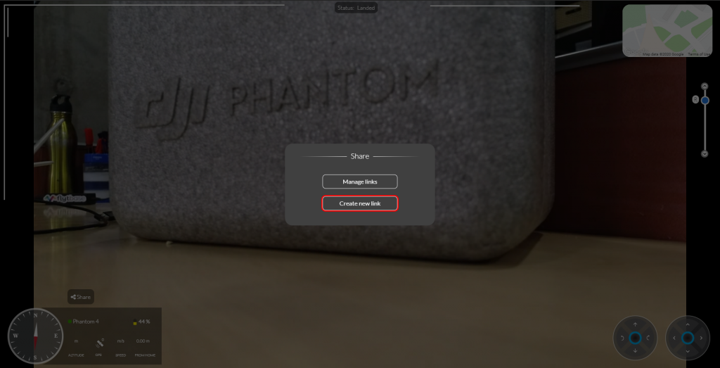
To initiate sharing click on the share button on the video panel

In the next dialog box click on Create new link.

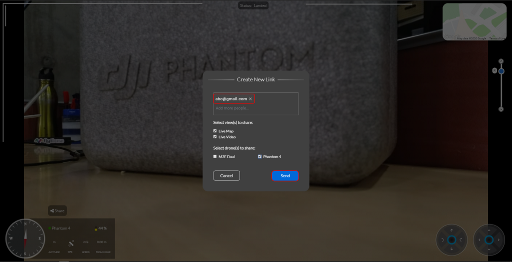
Enter the email address of the person to whom you want to share the video.

Select the drones and your preferred options. You get the option to share both the map and the video.
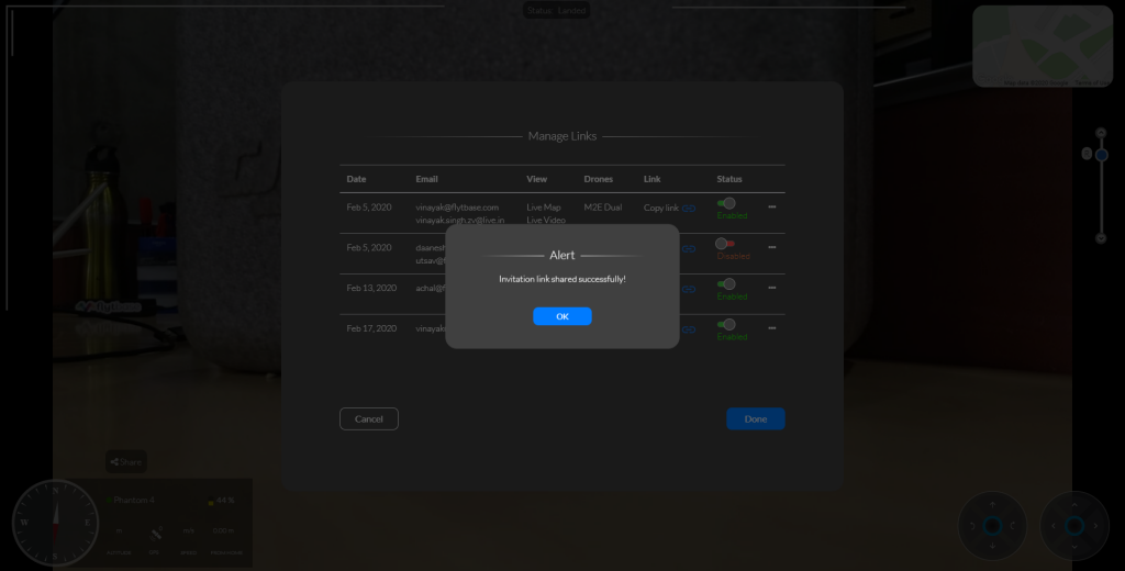
The person with whom you have shared the live feed gets an email with a secure PIN. Tell him/her to click on View Operation and enter the secure PIN to start the live streaming.

Initiating a Drone Delivery
Once you are done with the basic setup, it is time to launch your first delivery mission. Consider a situation where you have received a delivery request from a nearby medical center, and you are about to initiate a launch.
Step 1: Launching a drone and selecting a mission.
Under the FLY tab select a drone (has to be online) and click on the launch icon in the bottom right corner.

You will be asked to select a flight mode. Select Mission. In the next window, you will see all your missions. Select a mission and click on start.
Step 2: Completing the pre-flight checklist and executing the mission.
Next, you have to complete the pre-flight checklist.

Once you are done with the checklist, hit Execute to begin your delivery.

What’s the Next Step?
FlytNow Enterprise a Perfect Solution for Large Scale Drone Delivery Operations
We have been talking about FlytNow Pro which has limited features but ideal for validating an idea or doing a POC. Once you are done with the validation stage, it’s time to move to FlytNow Enterprise.
FlytNow Enterprise is a fully-featured comprehensive drone automation solution designed for large scale drone deployment. The solution is fully customizable and can be used in a variety of use cases, and drone delivery is one of them.
Here are some exclusive features of FlytNow Enterprise:
- Add and manage multiple drones, operators, and clients.
- Assign a drone to a delivery request.
- Generate automatic, unlimited flight plan (straight line) from drone location to the delivery location, edit if required.
- Control the gimbal, manually trigger RTH, and land for emergency situations.
- Recording of video streams.
- Set an advanced geofence - support of polygon geofence.
- Integrate with third-party services like DroneLogbook and UTM like Airmap.
- Integrate with Drone-in-a-box or charging pad like Skysense, WiBotic, Airscort.
For enterprise drones (DJI, PX4, Ardupilot), FlytNow provides SBC, with the FlytOS installed, for direct integration to make BVLOS flight possible over 4G/LTE/5G network. We also provide accessories and landing tag design for precision landing over charging pads.

--
Schedule a 30-min free consultation with our expert to learn more about the FlytNow Drone Delivery Software Solution, contact us at https://flytnow.com/contact/
Drones with cameras have both commercial and recreational applications. For commercial use-cases, the ability to live stream videos, with low latency, is crucial for the effective use of drones. This enables enterprise stakeholders to see things happening far away, in near-real-time, from a bird’s eye view. Many industries, sectors, and use-cases can leverage such remote drone operations, for example:
- Search & rescue
- Surveillance and security
- Monitoring and inspection
- Public safety
A cloud-connected, user-friendly solution can thus be leveraged by drone operators, specialized service providers, UAV system integrators, and enterprise drone program managers.
Multi-Camera Streaming via FlytNow
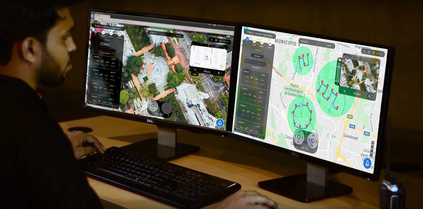
The capability to stream videos from multiple drones, simultaneously, is now available in FlytNow, the remote drone operations solution from FlytBase. Multiple camera (‘Multi-Cam’) streams can be viewed from a single operator dashboard, which can also be used to control multiple drones, their payloads, camera gimbals, etc.
Top 3 Use Cases of Multi-Cam Streaming
While there are numerous commercial applications that can benefit from drone fleets and multiple-camera streaming capabilities, these 3 seem to be gaining the most traction.
Security & Surveillance
Automated drone patrols are at the heart of surveillance of residential, commercial, and industrial premises. With the FlytNow multi-cam feature, surveillance drone operators can cover large areas from a single dashboard; it allows them to gain situational awareness during a security breach, with the added advantage of images & video surveillance from different angles.

Security stakeholders can combine different views (eg. thermal and normal camera feeds) and be much more effective during night time, low visibility conditions, etc.
Asset Inspection
Drones are used to inspect infrastructural and other valuable assets that are remote, hard to reach, or massive in size. With FlytNow, inspection personnel can view such assets from multiple angles, with the videos streamed in real-time, from multiple drones to a single dashboard in the command center or control room. This ability is useful in a range of remote inspection activities such as structural inspections, wind turbine inspections, cell tower inspections, oil & gas refinery inspections, and pipeline inspections.
Structural Inspections

Large structures under construction require to be inspected quite regularly – this includes visual observations of foundations, roofs, and key structural components. The inspection data provide insights into the overall condition, progress, and maintenance needs of such properties.

The traditional way of inspecting, which involved manual inspection of only some of the areas of a large structure, is severely lacking – not only in coverage but also in terms of safety. Drone footage, on the other hand, can both improve coverage, reduce inspection time, and eliminate almost all safety concerns. Drone fleets powered by FlytNow can give stakeholders automated aerial views, from multiple angles, of important but hard-to-reach structural locations.
Wind Turbine Inspections

Periodic inspections are an important part of the maintenance programs of wind-turbine sites, so as to maintain their efficiency, safety, and longevity. It’s important to check the structural integrity of the blades since different parts expand and contract differently under varying climatic conditions. Blades are also subject to damage from dirt, birds, snow, ice, etc.

Here, drones are now being used to rapidly, safely, and quickly scan the different parts of a wind turbine with highly calibrated IR sensors and high-resolution cameras. With FlytNow Enterprise, an inspector can capture different aerial views of a blade, control the camera gimbal remotely, and maintain a safe distance automatically.
Cell Tower Inspections

Cell towers are tall structures that need periodic inspections to keep them operational and safe. Drone-based inspections can help significantly reduce the amount of time that people have to spend on a tower for such inspections. Safety, speed, and cost are all factors in making remote aerial inspections more amenable for broad adoption. Using FlytNow, live streams from drone fleets can be delivered to a single dashboard; these videos can then be shared with guest users, regulators, and other stakeholders in cell tower inspections.

Refinery and Pipeline Inspections

Drones are being designed and deployed for corrosion detection, analysis of cracks, spillage, and leak detection in oil and gas refineries and along long-distance pipelines. The information gathered by drone fleets can be invaluable for maintenance and planning at these complex facilities, with billions of dollars of infrastructure at stake. The speed with which inspection data is gathered can be drastically improved using multiple, autonomous drones, powered by multi-cam streaming available via FlytNow.

Public Safety
The biggest risk in public safety is to first responders, who have to be on-site without timely situational awareness. They also have to deploy fire trucks, ambulances, police cars, and other equipment – without first being able to assess the situation.

US-based technology company Phirst Technologies, which focuses on public safety solutions, has integrated autonomous drones into the CAD system that supports the 911 service. The idea is to dispatch drones from a unified dashboard to assess a situation before sending human responders. The solution is called FIRST iZ, and they are using FlytBase technology to power their drone automation.
Drones thus offer a compelling capability for incident response – public safety authorities can deploy them first, gain real-time awareness, and make better-informed decisions about people and equipment deployments.
Search and Rescue

Drones are actively used worldwide for search and rescue operations because they can cover a large area in less time while providing a bird’s-eye view. In 2018, police in the UK used drones to find a semiconscious man on the cliff of Exmouth; they used thermal imaging to locate and save the person.
These capabilities are now available in FlytNow so that search parties can quickly dispatch a fleet of drones and stream the live footage from them to a single dashboard, thus expediting the search and rescue process.
Firefighting

Drones fitted with IR sensors can find people trapped in difficult situations such as forest fires where visibility can be quite poor. In 2018, fires scorched more than 150,000 acres in less than two weeks in California. 16 teams of public safety officials clocked 500 drone flights in 3 days. UAV flight data was used to aid search and rescue operations, and pinpoint the path of the fire.
Since such operations may require scanning a very large area, of the order of hundreds of square miles, features like multi-cam streaming are crucial for the deployment of a large fleet of thermal drones.
Law Enforcement

During the COVID-19 pandemic of 2020, drones deployed in the city of Ahmedabad, India helped monitor lockdown and mitigate the spread of the deadly coronavirus. A central command center was established, with the FlytNow dashboard receiving live video streams from multiple drones flying across the city.
—
To get started with FlytNow visit our Get Started Guide.
or contact us at https://flytnow.com/contact
Drone technology has witnessed a rapid maturity curve - with regards to not only hardware and software technology but also the use cases across industries and sectors. Consumer drones have gone past the typical use in film production and recreational uses. These prosumer off-the-shelf drones are now solving complex business problems - for example, in logistics, drones are being deployed to do last-mile delivery, managing inventory, and conducting security patrols.
In this blog, we will specifically focus on thermal imaging drones and the related use cases. Let’s start with an introduction to thermal imaging, understand how it works and how it might be used, via different drones and cameras, for commercial applications.
Need for Thermal Imaging
The ability to let people visualize what their eyes cannot, have led to the popularity of thermal cameras for conducting inspections and patrols. Owing to the invisible heat radiations emitted or reflected by all objects, such cameras record and produce an image of any object having a temperature above zero without the need for visible light. The hotter the object, the brighter it will appear in the thermal image (you can choose the color pallet accordingly).
Such differences in temperature of the objects under observation are then represented in different colors. Generally, blue shades are used to represent colder objects, while red shades are used to represent hotter ones.
 Thermal imaging has therefore been known to offer superior protection in demanding conditions. Some of the prime benefits include:
- Ability to remove blind spots
- Capture data in low-light or at night time
- Examine inaccessible areas
- Ability to see-through camouflaging foliage
Recommended Thermal Cameras for Drones
Drones with thermal cameras have resulted in unparalleled flexibility for many businesses that require constant protection against potential intruders. Adding a thermal camera as a payload, allows operators to view thermograms in real-time, with the ability to immediately identify objects from the radiation emitted.
Some of the key factors to take into consideration while choosing an appropriate payload aligned for business include:
- Is the camera radiometric or non-radiometric?
- A radiometric camera provides a temperature reading along with the thermal image.
- Does the camera come with a gimbal or a fixed mount?
- A camera with a gimbal offers greater control to the operator over the camera movement.
Here are some recommended payloads:

Popular Drones used for Thermal Imaging
Apart from having a fast turn-around time, drones are pocket-friendly as compared to installing thermographic cameras at several locations in the property with a higher possibility of blind spots. Some of the cost-effective drones that could quickly cover the entire facility and be used 24x7 for monitoring include:

Use Cases of Thermal Imaging Drones
Aerial imagery is the primary application of commercial drones; with a thermographic camera, drones can further add value for various enterprise applications.

More recently, during the outbreak of COVID-19, thermal cameras were widely used by the public safety authorities in many countries to detect infected people by checking body temperatures. Thermal drones were also used to identify people defying lockdown rules or social distancing guidelines imposed by many countries especially at night.
Why use FlytNow for Automated Night Surveillance
FlytNow Enterprise for Security and Surveillance enables drone operators, service providers, and enterprises to remotely operate a fleet of thermal drones.
An ideal solution due to the following capabilities:
- FlytNow provides geofencing and intelligent waypoint design that a security service provider can use to schedule patrols. The geofencing feature creates a virtual boundary for your drones. The platform allows the creation of unlimited flight plans and streaming of live telemetry to further aid such operations.

- The cloud-based platform provides live, low-latency streaming of thermal video from multiple drones on a single dashboard, which can be used to inspect a structure or situation from multiple angles and viewpoints.

An operator can remotely control the camera gimbal of drones connected to the FlytNow system, and thus effectively track different objects on the ground. With the AI detection feature, FlytNow allows the auto-identification of objects and humans.
- With FlytNow, one can share a live video feed with anyone using an URL, including the map view. This way, a FlytNow user can share his screen with someone who doesn’t use the platform.
- FlytNow provides integration with Airmap and DroneLogbook so users can scale their BVLOS flights.
- FlytNow integrates with Skysense charging pads so users can completely automate the launch, operate, and docking cycle of a drone. It also supports precision landing so drones can land on charging pads.
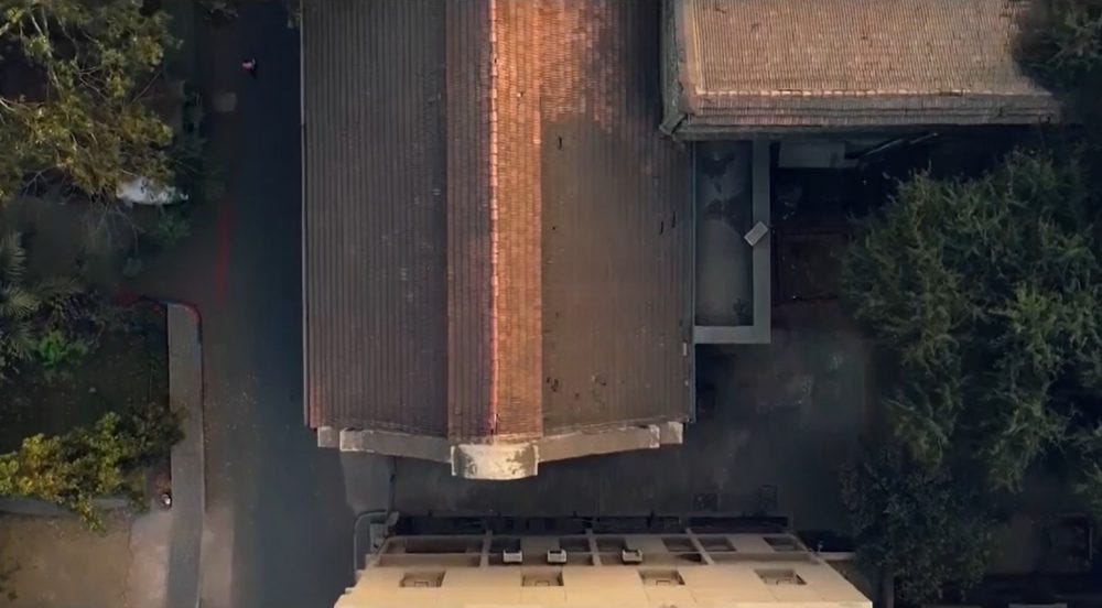
Here is an illustration of what drones with thermal imaging working at scale might look like.

---
To get started with FlytNow visit: https://flytnow.com/getting-started-with-FlytNow/
or contact us at https://flytnow.com/contact
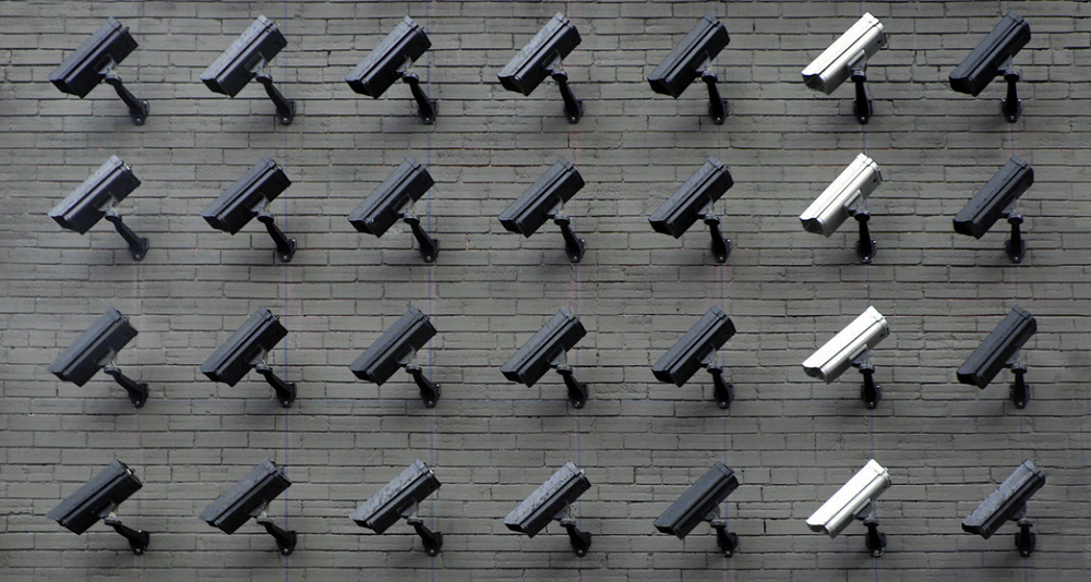
Observational surveillance systems rely on the capabilities of the cameras employed, but the main limiting factor is the stationary nature of the cameras in a traditional surveillance system. Now, surveillance can be achieved utilizing drones; it can be not only cost-effective but also accomplish the desired outcome more safely, efficiently and at a much larger scale. Security drones present a quicker, more economical method of aerial information collection.
Drone operations for the purpose of surveillance and security can now be automated using the FlytNow solution from FlytBase.
Benefits of Using Drones for Surveillance
Here are some of the benefits of using drones for surveillance.
- Security drones can reach confined and narrow spaces. They can be outfitted with detectors and night vision cameras, giving them a superior vision that can detect things that a human eye cannot.
- Drones can reach a spot much faster than humans, making them the ideal first responders.
- Drones can provide a birds-eye view of a situation from multiple angles, especially when deployed as autonomous fleets.
- Drones can keep humans out of harm’s way, by providing real-time situational awareness in dangerous situations.
- Drones can be fitted with IR sensors, thus making them effective even during night time.
- Drones powered by intelligent software bring in the capability to deploy complex analytics, mapping, and object detection features.
Use Cases for Surveillance Drones
Intruder Detection
A drone security system can be deployed for home security or monitoring commercial properties. They can relay live video footage, eliminate blind spots both during the day and nighttime — and follow and track trespassers and intruders, thus reducing the chance of theft.
Traffic Management
Drone surveillance can aid in real-time traffic control. They can improve situational awareness during accidents. Drones can employ analytics in traffic management that includes automatic vehicle count recognition, license plate identification, and tracking vehicular activities for improved safety and security.
Wildlife Protection
Forest officials face a constant threat of poachers hunting. Drones outfitted with thermal devices can replace stationary IR systems that are costly and not as effective. Surveillance drones have a fast turnaround time; they can be deployed on-demand and controlled from a base station.
Safeguarding Perimeters
Commercial and residential properties usually have pre-defined boundaries. Surveillance drones can track a target area from a safe distance with live updates of possible threats present at/inside the perimeter. Surveillance drones can operate even at night time with the help of IR sensors, thus avoiding harm to security guards and serving as ‘eyes in the sky’.
Crowd Management
The government can track large scale events and execute complex analytics like head-count evaluation, riot detection, and identification of law-breakers. Drones armed with speakers and beacons may be used for crowd control.
Protecting Borders
Surveillance drones can be used to monitor insecure border operations and dangerous zones. They can give live video feeds to security officials and other stakeholders, thus enabling them to make strategic decisions from safety.
FlytNow Enables Surveillance with Drones
FlytNow is a cloud-based, remote drone operations software that can be used to manage a fleet of drones from a single, user-friendly dashboard. The platform has intelligent features like geofencing, flight path design, precision landing, autonomous charging, collision avoidance, etc. that can be used for automating surveillance activities with drones.
The FlytNow dashboard is the command center from where operators can control multiple drones, which in turn are connected via 4G/LTE/5G. Users can stream live videos from the entire fleet of drones on a single dashboard, and can easily switch between map mode or video mode.
The FlytNow solution also integrates with the Drone-in-a-Box technology allowing enterprise users to completely automate the flight, patrol and docking cycle of a drone.
How can drones be easily, quickly adopted for security use-cases?
FlytBase offers a 28-day free trial for users to explore FlytNow Pro edition and its relevance to specific use-cases for security stakeholders. Customers can add their drone fleets, fly them autonomously, create flight plans & coordinate missions, set geo-fence and checklists, view and store live video footage and integrate drone operations into an existing system.
To get started with FlytNow visit: https://flytnow.com/getting-started-with-flytnow/
Here is an example of how professional drones can help firefighters during forest fires. Airbot was engaged to provide a bird's eye view and crucial informations on burning surfaces and fire travel. The drone is one of the best tool for providing this kind of data and help the operations officer in his decisions and organization of ground resources.
FlytNow Guest Link Sharing offers the capability to share live drone video feed and telemetry with teammates and clients.
Scroll down for the step-by-step tutorial.
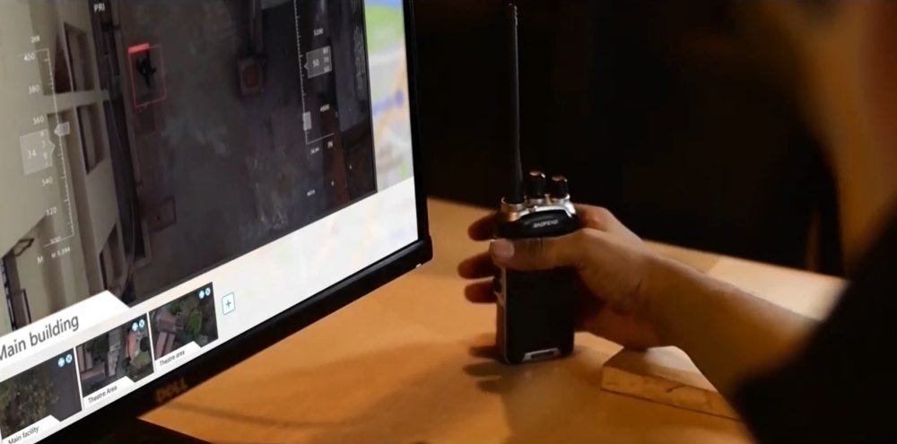
Remote Private Access to Drone Fleet, Live Video Feed & Telemetry
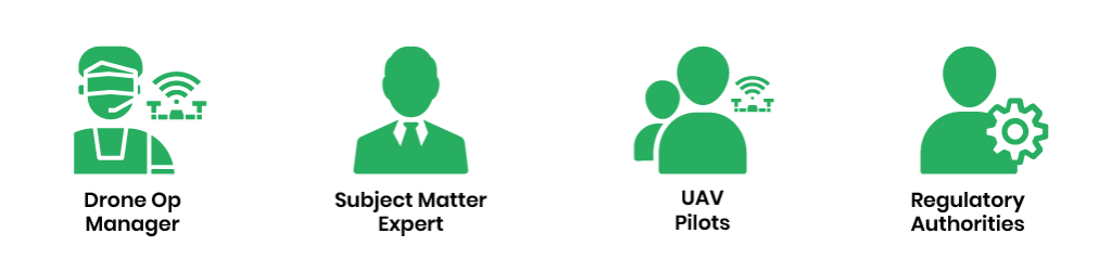
Enterprises worldwide are scaling their drone operations, as cost-effective drones become available off-the-shelf, and cloud-based SaaS solutions drive intelligent automation. One of the key drivers of drone fleet adoption is the ability for a variety of stakeholders to participate in drone missions. For example, an inspection of a wind turbine may involve on-site visual observers, remote subject-matter experts, safety managers from regional offices, R&D teams from corporate offices, technology partners — and even UAV regulators who seek insights into such missions before granting waivers for unmanned flights.
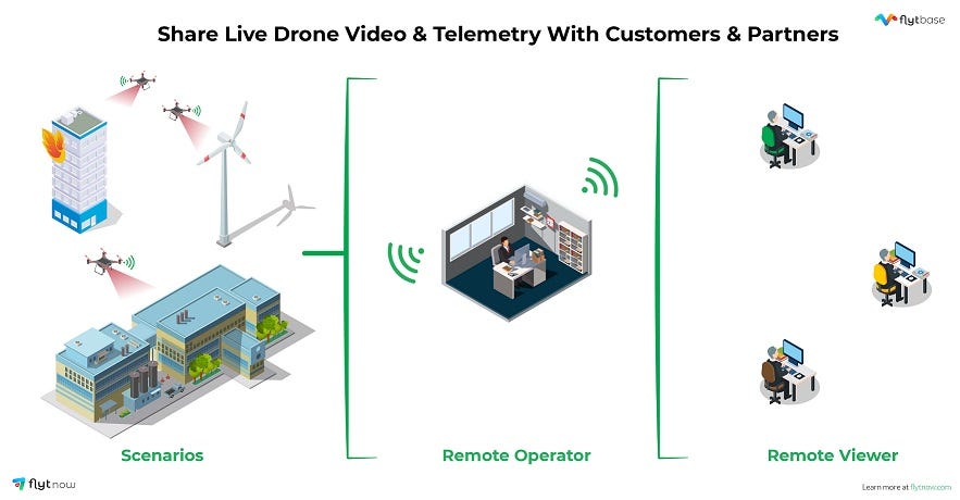
Live, remote drone operations thus require not only low-latency, high-quality video feeds, but also the ability to seamlessly share such video streams across people, geographies, devices and networks. In fact, enterprise drone programs tend to involve a variety of drone hardware — including off-the-shelf drones like DJI Mavic 2 Pro, Mavic 2 Enterprise, Matrice 210/210RTK, M600 Pro, etc., for day-to-day operations and custom drones built using DJI A3, Pixhawk or Cube based autopilots with high-end sensors for rare but critical use-cases.
User-level Access to Drone Missions
Given that privacy and security remain amongst the top concerns in the global drone ecosystem, enterprises have to carefully manage access to drone telemetry, live video streams, navigation, and payloads. With multiple, remote participants in each mission, fine-grained access — based on the roles and responsibilities of each participant — becomes central to successful drone operations.
Guest Link Sharing
It can be argued that many drone operations would be significantly more productive if secure, mission-wise remote viewing can be made available, over the Internet, via a user-friendly interface. Whether it’s a drone service provider monitoring construction sites or whether it’s the in-house drone operations manager supporting his/her colleagues for inspection of infrastructure assets, the access to live video streams — securely & remotely — can create immediate business value by enabling subject-matter experts to make better-informed decisions.
In fact, not only can remote viewers be empowered to access live video feeds in real-time, but remote operators can be given control of the drone, camera gimbal and payloads, with the on-site team serving as safety pilots and visual observers. Automating such live, remote drone operations then becomes the logical next step in the evolution and maturing of enterprise drone programs.
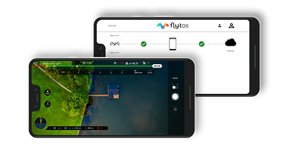
Drone Videos on Mobile Phones
Given the pervasiveness of mobile phones and tablets across businesses in all sectors, it is but natural for drone mission participants to expect these devices to be an integral part of the overall system. This is now easily possible via enterprise-grade mobile apps that can be easily customized, white-labeled and configured — making drone telemetry & videos extremely portable, especially in areas with robust 4G/LTE/5G networks.
Share Live Map Views, Drone Fleet Location, and other Mission-critical Data
Remote access for ‘guest’ participants in drone missions need not be limited to video — since live map views can also be seamlessly shared over the cloud, showing guest viewers the waypoints, flight paths, obstacles, etc. for each mission. Third-party maps can be integrated to overlay drone missions on satellite imagery, specific drones/payloads can provide IR/thermal camera views to remote stakeholders, and missions such as parcel delivery can be remotely monitored not only over the last-mile but all the way to the ‘doorstep’.
Aerial video streaming is thus becoming the core of drone operations for operators, service providers, system integrators and large enterprises — with secure, user-level access for remote participants the ‘killer app’ of this technology.
Tutorial: How to share live drone video feed and map view using FlytNow
Step 1: Log in to your FlytNow account and connect your drone to the application. Follow the FlytNow getting started guide if you are a first time user.
Step 2: Click on the “Share” icon on the video box or button in the Cockpit view
Step 3: Click on “Create new link” to generate a link
Step 4: Enter your teammate’s or client’s valid email address with whom you wish to share video & map view and click “Send”
Note:
- Choose appropriate options for view and drone access.
- You may enter multiple email addresses
Step 5: Teammate or Client receives an email with a link and Secure PIN
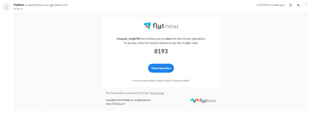
Step 6: Click on the “View Operation” and enter the Secure Pin. Your teammate or client can now securely access live drone feed and telemetry.
For any questions, you may write to us on info@flytbase.com or visit http://forums.flytbase.com/c/flytnow
How do I Deploy Commercial Drones Easily & Quickly?
FlytBase offers a 28-day free trial for users to explore the FlytNow Pro edition. Customers can add their drone fleets, fly them autonomously, create flight plans & coordinate missions, set geo-fence and checklists, view and store live video footage and integrate drone operations into an existing system.
Start Now and fly your drone(s) via a free trial in 5 Easy Steps.
The need for security and surveillance — whether residential or commercial — continues to steadily increase in a world of increasing volatility, uncertainty, complexity, and ambiguity. Privacy, not just security is becoming as much of a concern — with technology playing a central role on both fronts i.e. in violation of privacy and in the provision of security. This is where drones for security come in, powered by reliable hardware and intelligent software.
Traditional security systems (human guards, CCTV cameras, locks, access control systems, etc.) continue to prevail amongst security and surveillance providers. However, new technologies ranging from drones and robots to biometrics, AI and cyber-security have started to capture a larger share of the market. These technologies offer a range of benefits — automation, scalability, remote management, auditability, cost-effectiveness, reliability, mass customization and so on.
Use of Security Drones
Unmanned aerial vehicles (i.e. drones) are already part of the most advanced home and office security systems, with a fleet of drones programmed to launch from their nests, run repeated missions, capture aerial footage of the assets being secured, and return to their nests to charge and prepare for the next mission. By augmenting, if not replacing, human guards and static CCTVs, these ‘eyes in the sky’ can offer faster response to incidents, real-time situational awareness to the central command, live video feeds to remote stakeholders, and even serve as a deterrence to unfriendly elements.
Demand for Drones in Security & Surveillance applications
While regulation remains a challenge for outdoor operations such as aerial security and surveillance using drones, technology has advanced enough to enable drone-in-a-box security systems. These include not just drones, but also autonomous charging pads, weather-proof docking stations, intelligent automation via software, cloud connectivity and live remote operations. The key to large-scale adoption of such drone surveillance systems is their cost-effectiveness; which in turn requires the use of off-the-shelf drone hardware and SaaS-enabled solutions that minimize the upfront capital expenditure.
Importance of UAV for Residential & Commercial Security
Residential security drones have made the news in recent years, but it is industrial and commercial security systems that are seeing faster adoption. This is driven not only by enterprise initiatives in security automation but also by the rapidly increasing costs of human guards for drone security system providers, made worse by constant employee turnover.
By putting equipment, instead of humans, at risk of harm in case of adverse incidents, aerial surveillance drones minimize risk and enable better-informed decisions during security events. The best surveillance drones can, in fact, be rapidly sent to a location of interest, using GPS navigation and 4G/5G connectivity, to immediately stream live video feeds and even carry payloads such as sirens or warning lights. With thermal and IR cameras easily available, night-time drone patrols and alarms can be an integral part of aerial home/office surveillance systems.
Autonomous UAV Security & Surveillance Solution
Autonomy is — of course — the key to drones for security, since having human operators involved in UAV surveillance can not only add to the cost, but also introduce the risk of errors, or worse, loss of integrity of security operations. Software-driven automation of drones is thus driving their adoption for home security as well as industrial perimeter security. By defining specific points of interest, ideal schedules, and waypoint-wise camera action, such autonomous UAV security systems can be programmed to operate reliably and continuously and can be rapidly deployed across large swathes of residential or commercial areas. Automatic obstacle detection, collision avoidance and precision landing capabilities further expand the use-cases for drones in this context.
Making Drones Smarter for Security Solutions
By incorporating AI/ML techniques, image processing, and machine vision, drone security systems can even recognize things, track-and-follow intruders, and automatically identify objects that post threats. The physical size and weight of drones are reducing rapidly as the technology matures; such drones can make hard-to-reach locations easily accessible — and make harsh environments more secure — without putting humans at risk of harm.
Aerial video surveillance is thus turning out to be the next frontier for the security industry, powered by autonomous drone fleets that are intelligent, cloud-connected and remotely managed.
How can drones be easily, quickly adopted for security use-cases?
FlytBase offers a 28-day free trial for users to explore FlytNow Pro edition and its relevance to specific use-cases for security stakeholders. Customers can add their drone fleets, fly them autonomously, create flight plans & coordinate missions, set geo-fence and checklists, view and store live video footage and integrate drone operations into an existing system.
Start Now and fly your drone(s) via a free trial in 5 Easy Steps.

The commercial drone industry is rapidly maturing – across industries, geographies, use-cases, and business models – thanks to advances in UAV hardware and regulation. An incredibly rich variety of drone hardware has been built, tested, piloted and deployed for enterprise applications – ranging from ‘nano’ category drones for covert surveillance to large, custom-built drones designed to carry multi-kg payloads for last-mile e-commerce delivery.
Nevertheless, a large percentage of commercial use-cases involving drones revolve around the ‘eye in the sky’ capability – making live, high-quality video feeds from drones a key capability of enterprise-grade solutions. With the recent advances in AI/ML technology, the data captured by the drones’ camera can then be automatically processed – in the specific context of that use-case – to derive insights and make informed business decisions.
Live Video Streaming from Drones
Live views of an environment, asset, person, etc. – enabled by drones – are central to use-cases such as situational awareness during natural disasters, inspections of wind turbines and solar farms, intruder detection at secure sites, etc. Drones that stream live video are expected to augment, if not replace, humans as well as fixed monitoring equipment such as CCTVs – driven by their ability to use the 3D space, be remotely operated, carry payloads, be deployed in fleets, and made fully autonomous.
Video from Remote Drone Operations
In use-cases such as public safety, drones can provide live video streams to the emergency operators centers and help accelerate the incident response. In the security & surveillance context, drones can be operated remotely to capture live video, thus preventing humans from being put at risk.

Firefighters can deploy drone fleets all around the incident site to get a 360 degree, real-time video feed and thus employ the most suitable equipment and tactics to control the fire while minimizing safety risks.
From Drone Video Streams To Remote Drone Control
The latency of live video feeds from drones has been brought down to the 500-ms level, and the latency of drone telemetry is in fact much lower at 50ms. Enterprises can thus not only rely on near-real-time video feeds (with quality as high as 4K) from drone fleets – but they can even incorporate remote control of the drone and camera gimbal, into their workflows. Subject-matter experts, for example, need no longer go to the site for asset inspections; instead, they can control the drone from a corporate office, using the live video feed as immediate feedback, saving time, effort and expenses – and improving worker safety at the same time!

A variety of remote stakeholders can thus easily access drone videos simultaneously – with only the drone pilot/operations manager having to be physically on-site. In fact, varying levels of access can be designed to telemetry, images, videos and sensor data – thus ensuring data privacy and security, while empowering the right stakeholders to fulfill their roles in the context of enterprise drone operations.
Enhancing Live Video Streams from Drones
With the availability of cost-effective off-the-shelf drones and airframes, as well as a wide variety of payloads, drone solution providers are crafting the optimal solutions for commercial use-cases. The software of course plays a vital role in enabling drone stakeholders to plan, execute, log, monitor and repeat drone missions; the software will also be crucial in maturing most drone operations from manual to fully autonomous.
However, drone payloads such as thermal cameras, IR cameras, sirens, lights, camera gimbals, charging pads, etc. also are crucial for delivering value. Live video streams from dual cameras in drones can power night-time missions, while the ability to record video streams (on local servers or on the cloud) can support the investigation of security incidents and audits of security services.
Insights from Video Streams from Drones
The rich, real-time image and video data captured by drone cameras serve as a rapidly increasing repository of ‘training data’ for AI/ML algorithms to use as part of intelligent automation of enterprise automation. For example, live video feeds from drones that monitor industrial premises can be complemented with trained AI/ML models that can automatically detect humans, animals, and objects – and trigger security alarms. Similarly, video streams from public safety situations can be automatically analyzed to aid emergency response teams to identify suspects and/or victims in that context. Drone solution providers are in fact rapidly building capabilities to automatically detect weeds, pests, crops, cattle, etc. – with high-quality video data from drone fleets as the key enabler.