drone (24)

In recent years, advancements in drone technology have revolutionized various industries, from agriculture to search and rescue operations. Among these innovations, thermal imaging drones have emerged as a game-changer, offering unparalleled capabilities in a wide range of applications. In this article, we delve into the fascinating world of thermal imaging drones, exploring their uses, benefits, and the transformative impact they have on diverse fields.

Understanding Thermal Imaging Technology

At the heart of thermal imaging drones lies sophisticated infrared (IR) sensors capable of detecting and measuring heat emitted by objects. Unlike traditional cameras, which rely on visible light to capture images, thermal cameras detect infrared radiation, allowing them to visualize temperature variations across surfaces. This ability to "see" heat signatures makes thermal imaging drones invaluable tools for a myriad of tasks, especially in environments where visibility is compromised or where traditional methods fall short.

640t-thermal.jpg

Applications Across Industries

The versatility of thermal imaging drones transcends industry boundaries, finding applications in fields such as:

1. Search and Rescue:

In emergency situations, every second counts. Thermal imaging drones Autel EVO II 640T V3 equipped with infrared cameras can swiftly locate missing persons or detect heat signatures in disaster zones, even in low-light conditions or dense vegetation. Their ability to detect body heat makes them indispensable tools for first responders, significantly expediting search and rescue operations and improving outcomes.

dragonfish-thermal.jpg

2. Precision Agriculture:

Optimizing crop yield and monitoring plant health are paramount in modern agriculture. Thermal imaging drones provide farmers with invaluable insights into crop vigor, irrigation efficiency, and pest infestations. By detecting temperature differentials across fields, farmers can identify areas requiring intervention, such as irrigation adjustments or pest control measures, thereby maximizing productivity while minimizing resource usage.

3. Building Inspections:

Traditional methods of building inspections often involve manual labor and pose safety risks. Thermal imaging drones offer a safer, more efficient alternative by enabling inspectors to identify structural anomalies, insulation deficiencies, and moisture intrusion remotely. By detecting temperature variations indicative of potential issues, such as water leaks or electrical hotspots, thermal imaging drones facilitate proactive maintenance and prevent costly damage.

4. Wildlife Conservation:

Monitoring wildlife populations and combatting poaching are ongoing challenges for conservationists. At the same time, thermal imaging drones can be used to monitor the number and living habits of wild species and provide assistance for hunting wild boars, elk, coyotes, etc. Thermal imaging drone hunting has also become a pastime for most families in the United States.

thermal-drone-tree.png

5. Security and Surveillance: 

Securing critical infrastructure and ensuring public safety require robust surveillance measures. Thermal imaging drones enhance security protocols by offering enhanced visibility during nighttime operations and in challenging environments. From perimeter patrols to monitoring border crossings, these drones provide security personnel with a tactical advantage, enabling proactive threat detection and rapid response.

Advantages of Thermal Imaging Drones

The adoption of thermal imaging drones confers numerous advantages, including:

- Enhanced Visibility: Thermal imaging drones excel in environments with poor visibility, such as dense foliage, smoke, or darkness, thanks to their ability to detect heat signatures.

- Remote Monitoring: By capturing thermal data from a distance, drones eliminate the need for manual inspections in hazardous or hard-to-reach locations, enhancing safety and efficiency.

- Cost-Effectiveness: The use of drones for aerial inspections and surveillance reduces operational costs associated with manned aircraft or ground-based methods, making it a cost-effective solution for various industries.

- Data Accuracy: Thermal imaging drones provide precise temperature measurements and detailed thermal maps, enabling informed decision-making and targeted interventions.

Challenges and Future Outlook

While thermal imaging drones offer tremendous potential, they are not without challenges. Issues such as limited flight time, regulatory constraints, and data interpretation complexities require ongoing innovation and collaboration to address effectively. 

However, with advancements in drone technology and continued research, these challenges can be overcome, unlocking even greater possibilities for thermal imaging applications.

Looking ahead, the future of thermal imaging drones is promising. As their capabilities evolve and their adoption becomes more widespread, we can expect to see further integration into diverse industries and novel applications emerging. 

From environmental monitoring to infrastructure inspection, thermal imaging drones are poised to redefine how we perceive and interact with the world around us, ushering in a new era of innovation and progress.

In conclusion, Thermal imaging drones for sale have made their way into our surroundings and have great potential to revolutionize multiple fields by harnessing the power of infrared technology and aviation capabilities.

Read more…

12404060885?profile=RESIZE_710x

Embarking on the thrilling adventure of FPV (First-Person View) drone flying is a journey of skill, precision, and aerial exploration. For both novices eager to take their first flight and experienced pilots looking to refine their maneuvers, FPV drone simulators offer a risk-free and immersive platform to practice and perfect flying techniques. This comprehensive guide shines a spotlight on the diverse world of FPV drone simulators, helping you navigate through the options to find the simulator that best matches your flying dreams and proficiency level. In the real fpv drone, you can use meps 2806.5 , meps 2408meps 1804.

Leading FPV Drone Simulators Breakdown

  • Beginner-Friendly Choice: DRL Simulator
  • Racing Purists and Users with Legacy Systems: VelociDrone
  • For Lovers of Freestyle and Cinematic Flights: Tryp FPV
  • A Well-Rounded Pick for Various Styles: Liftoff
  • Tiny Whoop Enthusiasts' Go-To: Tiny Whoop GO
  • Best Free and Mobile Option (Android): SkyDive

Delve into the specifics of these simulators to identify your ideal partner in FPV flight training.

Understanding FPV Drone Simulators

FPV drone simulators serve as virtual gateways to the world of drone piloting, offering a realistic and engaging experience of flying drones from a first-person perspective no matter what kv you use such as 11000KV brushless motor4600KV burshless motor. Far from being mere games, these simulators are sophisticated training environments that mimic the physics and dynamics of real-world drone flight. They provide a safe and controlled setting for pilots to enhance their flying abilities, without the concerns of weather or the potential for costly accidents.

Embarking on Your Simulator Journey

To truly benefit from an FPV simulator, using a radio controller that mirrors real-world drone controls is crucial. This approach ensures skill development that translates directly to actual drone flying, thanks to muscle memory. The simulators highlighted in this guide support most radio controllers with USB connectivity, ensuring a smooth transition to the virtual skies.

If your controller lacks USB support, don't worry—there are solutions involving a flight controller and receiver to bridge this connectivity gap.

The Convenience of Steam

Steam is the primary distribution platform for accessing a wide array of FPV drone simulators. It provides a user-friendly interface for purchasing, playing, and updating your simulation software. Steam’s consumer-friendly return policy also allows you to explore different simulators risk-free, ensuring you find the perfect match for your needs.

Exploring Each Simulator in Detail

Tryp FPV

New to the scene but making waves with its stunning graphics and expansive environments, Tryp FPV appeals to pilots with powerful gaming setups looking for a visually immersive flying experience. Although it may not offer the most comprehensive training tools, its customization options and variety of maps make it a paradise for freestyle and cinematic drone pilots.

Uncrashed

Uncrashed stands out for its exceptional visual fidelity, offering an immersive and smooth flying experience that sets a new standard in aesthetics. While its focus on freestyle over racing might not cater to everyone, its engaging maps and activities promise a rewarding flying adventure.

Liftoff

Striking a balance between features, accessibility, and price, Liftoff caters to a broad spectrum of pilots, from beginners to experts. It may not specialize in any particular niche, but its comprehensive suite of features and strong community support position it as a highly versatile and appealing choice.

VelociDrone

Dedicated to the racing community, VelociDrone excels in delivering realistic flight physics and a competitive racing experience. Its efficient performance on older computers and a vibrant multiplayer community make it a favorite among racers and those looking to push their limits.

The DRL Simulator

With a robust set of features at an accessible price, the DRL Simulator is tailored to a wide audience, offering something for everyone. From comprehensive training modules to competitive multiplayer racing and the chance to participate in real-world DRL competitions, it presents a full-fledged FPV flying experience.

Concluding Thoughts

FPV drone simulators are invaluable assets for drone pilots, offering a practical and enjoyable means to refine flying skills in a risk-free environment. By selecting a simulator that aligns with your flying goals and preferences, you can significantly enrich your FPV journey. Here's to soaring to new heights in your FPV piloting adventure!


Read more…

The Growing Challenges in the Solar Industry

The solar industry is booming, with a 45% rise in global solar installations in 2022 alone. However, this rapid expansion brings its own set of challenges. Labor shortages, cost pressures, and the need for greater transparency are just a few of the hurdles that solar companies face today. Traditional methods of managing solar farms, such as manual inspections and data collection, are becoming increasingly inefficient and costly.

Consider the time and resources spent on manual inspections. A company like AfterFIT in Tokyo reduced their inspection time from 3 hours to under 10 minutes by using drones. The manual approach not only drains resources but also exposes workers to potential hazards. Moreover, human errors can lead to inaccurate data collection, which can have severe consequences, including reduced power generation and even safety hazards.

The Rise of Autonomous Drones and Data Analytics

The Role of Drones in Solar Industry

Drones are revolutionizing the solar industry by aiding in every stage of a solar plant's life cycle—from planning and construction to maintenance. They can perform tasks like topographic surveys, 3D mapping, and even thermal imaging to detect hotspots in solar panels. On average, drones have expedited data collection by 70% compared to manual methods, all while maintaining high accuracy.

Key Components and Benefits of Autonomous Drone Operations

Autonomous drones take this a step further by eliminating the need for human intervention in data collection. These drones are equipped with advanced software platforms like FlytBase, which ensures safe flight operations, data security, and regulatory compliance. Hardware components like the DJI Dock allow these drones to operate autonomously, following predefined routes and returning to the docking station without human intervention.

Key Benefits Include:

  • 24/7 Availability: Operates round the clock, ensuring continuous data collection.
  • Cost Savings: Reduces travel costs and optimizes resource utilization.
  • Reduced Human Risk: Minimizes risks associated with manual piloting.

Integrating Data Analytics for Comprehensive Insights

Data analytics platforms like Above’s SolarGain can be seamlessly integrated with autonomous drone technology. These platforms utilize machine learning to provide real-time situational awareness and detailed plant status reports. This digitalization offers a single source of truth for solar plant health, supports digitalized workflows, and enables a data-informed approach for better decision-making.

The Way Ahead

The most effective way to adopt this technology is through a phased approach. Start by deploying drones at one or a few sites to establish standard operating procedures and build a strong safety record. This sets the stage for a seamless transition to end-to-end automation and efficient solar energy management.

Conclusion

The future of the solar industry lies in automation and digitalization. Autonomous drones and data analytics platforms are not just a technological advancement; they are a necessity for solar companies aiming to stay competitive in this fast-growing market. By adopting these technologies, companies can significantly improve efficiency, reduce costs, and most importantly, contribute more effectively to the global shift towards cleaner energy.

Are you ready to take your solar operations to the next level? Don't miss out on the comprehensive guide that dives deep into the transformative power of autonomous drones and data analytics in the solar industry.

Download the Whitepaper: Navigating the Future of Solar with Autonomous Drones and Data Analytics

For more information, visit FlytBase and Above Surveying.

Read more…

11073136453?profile=RESIZE_710x

Aerial drone/Agriculture drone/Heavy lift, cargo drone. All power by T-MOTOR.
T-MOTOR is well-known as a worldwide drone motor, drone ESC, and drone propeller manufacturer that provides industrial drone BLDC motor, ESC, and carbon fiber propellers with 13+ years experience. With our principle of being quality-oriented, our drone parts are recognized in a very short time by many famous drone companies.
-BLDC Motor Power Range: 0-40KW+
-Propeller Diameter: 0-62inch+
Prompt support on Whatsapp: +86 1307752712/ Email/Jessica@tmotor.com

Read more…

How Drone Autonomy and AI are Revolutionizing the Mining Industry: Advancements and Impact

Discover how autonomous drones and AI are transforming the mining industry with improved efficiency, safety, and accuracy. Learn about the latest technological advancements that are driving this revolution.

 
Last updated on
March 13, 2023
 
 
The mining industry may not be the most glamorous, but it is undeniably important to the global economy, providing us with the raw materials necessary for everything from building infrastructure to powering our electronics.

In recent years, the industry however, has faced criticism for its environmental impact and the safety of its workers. As a result, the use of more drones for mining, autonomy, and artificial intelligence (AI) in mining has emerged as a potential solution to these challenges.

During one of the NestGen'23 sessions, we spoke with Christopher Clark, CEO of Delta Drone International (ASX:DLT), a multi-national drones-as-a-service business dedicated to solving real-world challenges in the enterprise mining and agricultural industries by providing fully outsourced aerial drone data and solutions. 

In the session we discussed how a combination of drones, autonomy, and AI can help mining companies address many of the challenges they face and pave the way for a more efficient mining industry.

Here’s what he had to say 👇

How a Combination of Drone Technology, Autonomy & AI are Redefining Mining Operations

Drone technology is increasingly being used in the mining sector to enhance safety and efficiency. They provide access to difficult or unsafe areas like mine pits, tailing dams, and stockpiles. Drone surveys and mapping of mining sites quickly and accurately, allow companies to generate digital surface models and digital elevation models to not only provide an accurate representation of the site but to also optimize processes such as ore extraction and waste removal.

Additionally, drones monitor mining equipment and infrastructure, like conveyor belts and processing plants, for wear and tear, enabling timely maintenance and reducing downtime.

By adding autonomy & AI to this mix, mining companies can gather data of large mine sites and monitor operations around the clock, without human operators, improving productivity and efficiency. AI can further analyze data to identify patterns and trends difficult for humans to detect. Companies can therefore have systematic data to make better decisions and reduce costs by identifying inefficiencies and areas for improvement.

As Christopher puts it, "By combining drone autonomy and AI, a unique recipe begins to take shape. We can detect people and vehicles by applying AI models to thermal imagery captured by drones. When combined with autonomous drone-in-a-box solutions in mines and dangerous areas, it enables frequent drone flights that only activate when a vehicle or person is detected, presenting an exciting opportunity for drone autonomy and AI to collaborate."

Some of the most promising applications of autonomous technologies and AI in the mining industry:

1. Safety and reducing accidents

Safety and reducing accidents in mining sites

By using autonomous systems and drones equipped with AI, mining companies can improve safety by reducing the need for workers to enter hazardous areas, such as steep slopes or unstable ground. These technologies can detect and predict safety hazards, allowing for proactive measures to prevent accidents.

Just to set some context, Christopher shares a typical scenario in a mine-site - “If you wanted to calculate the volume of a stockpile and essentially how much a mine is digging out the ground, you would have to send men who would manually walk these 30, 40 meter high stockpiles. Sometimes these could be coal stockpiles really, which sort of have the propensity to spontaneously combust. So your shoes would be melting, even as you're walking over these stockpiles. And drones being able to immediately remove these types of surveyors from these stockpiles to provide them with immediate safety value. And we were very excited to see how drones have quickly become a part of the mining industry's daily routine and are only growing."

2. Productivity and efficiency

Increase productivity and efficiency at working sites

Autonomous drone systems enable mining companies to access hard-to-reach areas and monitor equipment and infrastructure on mine sites such as conveyor belts and processing plants for wear and tear, reducing downtime and preventing breakdowns. AI can further optimize mining processes like ore extraction and waste removal, leading to increased productivity and reduced costs.

3. Decreasing environmental impact and increasing sustainability

Drones and sensors monitor mining's effects on ecosystems, then AI analyzes the data to find improvements. These technologies enable targeted tracking of mining exploration' impact and efficient resource use, which minimizes damage and promotes responsible practices.

Reducing environmental impact through drones and AI

Successful Case Studies of Automation in the Mining Industry

A. Rio Tinto's Mine of the Future Program

Christopher highlights how Rio Tinto's Mine of the Future program is a successful example of utilizing technology to improve safety, productivity, and cost-effectiveness. Launched in 2008, the program uses autonomous technologies and AI to enhance mining processes. By incorporating autonomous trucks, drills, and trains, the company has decreased the number of workers on-site, while simultaneously improving safety and efficiency.

Rio Tinto's Mine case study

The Gudai-Darri Mine in Western Australia is an impressive instance of this program, as it is fully autonomous and remotely controlled from a central operations center, where workers monitor the mine's operations and make real-time decisions based on data gathered from sensors and cameras.

This mine has been very successful, with Rio Tinto reporting significant value and improvements in safety, productivity, and cost reduction. With the use of autonomous technologies and AI, Rio Tinto has been able to minimize waste and increase accuracy in mineral extraction, resulting in better efficiency and productivity.

B. Barrick Gold’s Digital Transformation

Barrick Gold’s Digital Transformation Case study

Barrick, one of the world's leading gold mining companies, has implemented a range of innovative technologies to improve safety, efficiency, and sustainability in their operations. These include:

  • Autonomous Haulage System (AHS): Powered by advanced sensors and GPS technology AHS allows the trucks to navigate the mine site and transport materials safely and efficiently without any human interference.
  • Predictive Maintenance: Using data analytics, Barrick anticipates equipment failures before they occur. This allows for proactive maintenance, reducing downtime and improving productivity.
  • Real-time Data Analytics: The company has invested in a real-time data analytics platform that enables them to collect, store, and analyze data from every stage of their mining operations. This allows for more informed decision-making, optimization of processes, and better resource allocation.
  • Digital Mine Planning: By using advanced digital mine planning tools, Barrick created accurate and detailed models of the mine site, optimizing the layout of equipment and infrastructure, and minimizing waste and environmental impact.
  • Safety Improvements: Barrick has implemented a number of safety initiatives, including the use of wearable technology to monitor workers' vital signs, real-time monitoring of hazardous areas, and the incorporation of safety protocols into their autonomous technologies.

Read Full Case Study

FlytNow for Autonomous Drone Data Collection

Automation software such as FlytNow, enables businesses to deploy drone fleets on routine missions to capture visual data in real-time. Mine operators can schedule missions at a regular interval to track the progress of work in mining sites from the comfort of their offices.

Live drone inspection of a mining site

Multi cam footage from different mining sites

Alarm monitoring system

Apart from rapid data collection, FlytNow enables companies to integrate alarm monitoring systems, which enable drones to autonomously take off from docking stations, fly to precise locations, capture video feeds, relay them back to the command center, and return to the docking station without human interference.

This feature provides mine operators with quick access to accurate incident reports, allowing them to respond promptly and effectively to any issues that arise.

contact us page

What's Next?

As with all disruptive technologies, the mining industry needs to overcome several challenges in implementing autonomous technologies and AI. While the benefits of these technologies, such as faster data insights, improved decision-making, and increased safety for workers, are vast, mining companies must also overcome regulatory hurdles, invest in necessary infrastructure and expertise, and ensure compatibility with existing systems. The adoption of these technologies promises to revolutionize mining processes, making them more efficient, productive, and safer.

It is worth noting that autonomy in mining applications will require a higher degree of analytical and electrical skill sets, but it does not necessarily mean a reduction in the workforce. Furthermore, the interoperability with downstream technologies such as wearables will empower situational awareness and safety. With proven platforms, drone swarms or fleets will unlock logistics and on-site deliveries for mine employees, leading to more streamlined operations. Overall, the mining industry's adoption of these technologies will enable them to remain competitive and better equipped to face the challenges of the future.

Read more…

10945479301?profile=RESIZE_710x

Our high-endurance development platform, named "Grasshopper" is perfect as a development platform, surveillance drone, or even a light show drone.

It is compatible with all the Micasense cameras and the Parrot Sequoia and has a flight time of up to 1hr with 200g of payload.

As optional we offer our satellite telemetry system for BVLOS flights.

The base version of the drone has a 580mm wheelbase and a 160.000 Mah battery.

Pricing starts at 1600€.

For more information, please get in touch with us at heimdallai@gmail.com

Read more…

Grasshopper: LOW COST NDVI CAMERA

10891615055?profile=RESIZE_710x

The Grasshopper NDVI is the newest in our line of simple-to-use survey cameras. Every Grasshopper NDVI camera allows the connection to an external USB GPS receiver to automatically geo-tag each captured image. Its 8MP sensor and sharp non-fisheye lens allow you to capture aerial media easily. It captures photos on the default timer trigger or can be sent a PWM signal through the HDMI port (see below). If you supply power to the USB port it will power on the camera automatically. Sized similar to a GoPro® Hero these small survey cameras can be attached to your aerial drone platform using our various mounts.

This Red+NIR (NDVI) model sees Near Infrared 850nm and Red 660nm light. The images from this camera are commonly calibrated into an index image and then a colored lut is applied to show contrast between healthy and poor health vegetation.

Starts at 239€

Check it out

For inquiries: heimdallai@gmail.com


Read more…

Enterprises & Startups can leverage FlytNow APIs to build & scale automated, cloud-connected drone applications, and reduce time-to-market.

The commercial drone industry is heading towards complete automation. This transition calls for seamless integration with different software & hardware. At FlytBase, we are cognizant of this ever-growing need for scalable enterprise applications that involve drones. Keeping this in focus, we are introducing FlytNow API platform to enable automated, cloud-connected drones applications for enterprises & startups.

We are proud to announce that we are extending the capabilities of FlytNow as a comprehensive backend platform for enterprise drone ops. We introduce FlytNow APIs to securely connect drones with any type of business application that supports RESTful architecture. This means that businesses can rapidly build and scale custom drone applications to manage their drone fleet.

Key benefits of using FlytNow APIs

  • Simple: FlytNow APIs are simple with clearly defined endpoints to perform specific functions.
  • Powerful Abstractions: FlytNow APIs provide powerful abstractions so developers do not have to deal with lower-level languages to communicate with drones.
  • Hardware Agnostic: Whether it is a DJI, PX4, or ArduPilot drone or any companion computer (like Rasberry Pi 4b, Nvidia Jetson, ODROID N2, etc.), FlytNow APIs are agnostic and have the necessary adapters to communicate with the hardware. These APIs
  • Discoverable: Our API endpoints are logically organized in extensive documentation so that even new developers can get up to speed quickly with the capabilities.
  • Consistent: All our API endpoints are constructed logically so that developers can anticipate different functionalities.
  • Virtual Drones: As the name implies, these are simulated drones in a virtual environment. Work on simulations to test your applications faster without risking expensive hardware.
  • Scalability: Our cloud services are hosted on Amazon AWS, and it is adaptive making it possible to deploy resources as you grow your business.

APIs that are currently available for our enterprise users


  • Navigation APIs: Control drones remotely from a dashboard.
  • Telemetry APIs: Fetch telemetry data like speed, altitude, global position, etc. from a drone.
  • Payload APIs: Control & integrate various payloads with FlytNow.
  • Video Streaming APIs: Access live video streaming from a drone. Share this stream with your team and guests for collaboration.
  • Vehicle Setup APIs: Perform a series of checks on the operational capabilities of a drone.
  • Gimbal Control APIs: Remotely control the gimbal pitch of a drone.
  • Camera Zoom APIs: Change the orientation of the camera and the zoom remotely.
  • Command & Control APIs: Send drone to a GPS location, control heading remotely.
  • Mission Planning APIs: Set a pre-programmed mission/path for a drone.
  • Precision Landing APIs: Land drones precisely on a machine-generated tag.
  • Collision Avoidance APIs: Integrate collision sensor data with FlytNow dashboard and set thresholds to avoid collisions.
  • Drone-in-a-box API: Integrate with Drone-in-a-Box hardware. Command drone launches and landings remotely. Moreover, you can retrieve charging (or battery swapping) & docking station statuses.
  • Geofence APIs: Set a virtual boundary for drones and trigger fail-safes in case of breaches.

What enterprises & startups can build using our Drone APIs

Drone-based autonomous security and surveillance system:


Security systems can be enhanced using drones. A custom enterprise web application can be integrated with CCTV cameras & software (for example Video Management solutions like Milestone), motion sensors, and ground-based hardware using FlytNow APIs. Further, businesses can leverage these APIs for mission planning to automate the patrolling of drones, thereby reducing the need for redundant manpower. Automation need not be limited to just spontaneous patrolling; it can be scheduled for regular security patrols using APIs for DiaB (Drone-in-a-Box hardware). Absolute autonomy lies in eliminating human interference starting from time-defined missions where the drone takes off, performs the mission, and docks back into the box to charge/swap batteries. In real-life, the system will leverage a unified dashboard as a command center and our live video streaming APIs to manage the entire operation. In the event of an intrusion, it will operate in the following way:

  • An intrusion alert goes off in the main dashboard. API integration with FlytNow triggers the drone system.
  • The system creates a waypoint mission for the drone. A drone automatically launches from a DiaB station and goes to the point of interest.
  • The drone begins live-streaming, and the human operator identifies the intruder from the live drone footage. The operator uses the payload APIs of FlytNow to maneuver the camera and look around. AI-detection technology can also automate intruders and help track in the video.
  • On completion of the mission, the drone automatically returns back to the docking station.

Drones-based medical delivery system:


Companies have been actively building & deploying drone systems that can deliver critical medical payloads to remote locations. A US-based company called Zipline is one such company that has extensive operations in the African nations of Ghana and Rwanda. They rely on a centralized system where they operate from a medical warehouse and all incoming requests for blood are fulfilled via drone delivery. The highlights of the system are that the drones can fly autonomously from the warehouse to the delivery point, drop the payload, and return back to the base. Following are some APIs of FlytNow can be used to build a similar system:

  • Mission Planning APIs: To set the route of a drone to the delivery location.
  • Navigation APIs: To take control of a delivery drone remotely in case of an emergency.
  • Vehicle Setup APIs: To run a diagnostic of a drone before sending it off to a mission.
  • Video Streaming APIs: To remotely monitor a delivery mission through a video feed.
  • Geofence APIs: To restrict the area of operation of the drones.
  • Command & Control APIs: Send drone to a GPS location, control heading remotely.
  • Collision Avoidance APIs: To get data from the onboard sensors and set thresholds to avoid collisions.
  • Payload API: To control the payload dripper or actuators

Drone-based emergency response system:


Leveraging the FlytNow APIs, a response system can be built that is fully autonomous and integrated with a Computer Aided Dispatch system like 911. In the event of an emergency, an operator using such a system can dispatch a drone to survey the situation. On receiving the command, a drone will launch and fly to the location autonomously and begin acquiring data using its onboard camera. The operator can share the live feed of the drone with the first responders who can plan a better response.

The APIs used in this case would be similar to the delivery system mentioned above, with a focus on BVLOS capabilities and live-stream of data.

Summary


In this blog, we introduced the APIs of the FlytNow platform and the benefits of using them. In a nutshell, FlytNow is built for developers building applications to manage enterprise drone operations with BVLOS capabilities. Our extensive and reliable set of APIs is a result of our experience working with commercial drones for almost a decade. Originally published on FlytNow

Read more…

If you are looking for the hardware to diy a drone by your own?

If you find it's hard to get the drone parts with competitive cost?

If you are looking for a drone with light weight and long endurance?

T-Drones is here happy to offer the solutions.

T-Drones M690A 0.5-1kg payload, 60-70mins flight time by battery;
T-Drones M690B 1-2kg payload, 50-60mins flight time
T-Drones M690 folding version , 350*320*130mm size to take away.
 

Any query:

Email: t-drones@outlook.com

What's app:+ 86 15070853230

LinkedIn

Read more…

drone delivery solutionCommercial drones are now becoming a mainstream technology, with the 2020 pandemic serving as a showcase for how drones can save human lives.

Drones have been used for delivery long before Amazon announced its Prime Air service. Founded in 2011, Zipline, a US-based company focused on medical drone deliveries became the pioneer in long-distance drone delivery, with distribution centers in Rwanda and Ghana. With an exponential growth since then, Zipline now delivers 65% of blood samples in Rwanda, particularly because the country lacks suitable road connectivity.

Companies like Zipline are investing heavily not only in better drone hardware but also in remote operations software, so they can intelligently & centrally manage a large fleet of drones.

How Does Drone Delivery Work?

Drone delivery refers to the act of moving a package from point A to B using unmanned aerial vehicles (UAVs). Such UAVs are either autonomous or remotely controlled by human pilots.


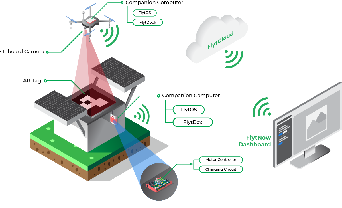
The infrastructure that powers drone delivery operations requires seamless integration between reliable drone hardware and robust software that can enable EVLOS/BVLOS Operations. The components of such systems include:

Drone Hardware

Drones that are capable of carrying heavy payloads; for example:

drone for delivery solution

Links to above-mentioned drone specs:

Companies like Zipline, Wing, etc., have their own fleet of drones specifically designed and developed to suit their specific delivery needs.

Note:

  • The above specifications are as given on the DJI and Foxtech website.
  • FlytNow is compatible with all DJI, Ardupilot, and PX4 based drones and provides software modules for EVLOS/BVLOS operation over 4G/LTE, 5G, Long-range RF.

Drone Fleet Management Software

drone delivery app

Drone delivery requires an advanced fleet management software like FlytNow that helps plan & execute long-range EVLOS/BVLOS flights with live tracking and drone control over 4G/LTE/5G.

FlytNow Delivery is a cloud-based offering that can be used for package delivery operations. Delivery businesses can use off-the-shelf or custom drones to quickly set up a delivery system in their geography. FlytNow solution cuts the deployment time to a few days and gives a unified web-based dashboard to control and manage every aspect of a drone delivery operation. FlytNow Delivery Offers:

  • Operator Dashboard - Centralized web-interface to manage all logistics operations
  • Dispatcher Dashboards - Web interface for store-fronts/medical centers to create delivery requests and live tracking.
  • Recipient Dashboard - Web and mobile interface to live track drone location and delivery status

Onboard Drone Software:

A drone equipped with intelligent onboard software make this kind of operation autonomous and safe. With the integration of FlytOS intelligent modules and sensors with onboard SBC (Nvidia Jetson Nano, DJI Manifold 2, Raspberry Pi 3B+/4), drones can do:

  • Autonomous Precision Landing or Hover (see FlytDock)
  • Collision Avoidance (see FlytCAS)
  • Electro-mechanical gripper control for package pick and drop
  • Electro-mechanical pulley control for releasing a package from a height.

Drone-in-a-Box (DiaB) Hardware:

For operations to be autonomous and efficient -- physical, on-ground components such as a docking station, charging pad, launching systems, etc. are required. With FlytNow DiaB integration enables remote control & telemetry in the same delivery interface. Our enterprise solution also offers integration with DiaB APIs. Below are a few DiaB and charging pad solutions for reference:

UTM Integration:

Airspace intelligence and management is a critical enabler for scalable, safe, beyond-visual-line-of-sight (BVLOS) or extended-visual-line-of-sight (EVLOS) enterprise drone programs. Such integration with a UTM engine or national airspace services can augment sense-and-avoid capabilities with regards to airspace, flying advisories, and weather information for optimal path planning while avoiding no-fly zones and manned aircraft. Some leading UTM and providers are:

  • Airmap
  • Attitude Angel
  • Unifly
  • Airpalette
  • DigitalSky (for India)

Learn about the FlytBase partnership with AirMap here

FlytNow can be integrated with any 3rd party private or government UTM API services.

Advanced Fail-safes:

Whether you are flying in rural or suburban areas, the safety of people on the ground and expensive drone equipment is of utmost importance. Emergency situations like flight system failure, bad weather conditions, or immediate advisory from the local aviation authorities may happen anytime.

In addition to standard drone fail-safes (RTH, Geofence, etc.), FlytNow provides Emergency Landing Point (ELP) Failsafes. ELP Failsafes allow you to define landing points along your delivery route and land the drone on the nearest ELP when a situation arises.

FlytNow also provides advanced geofence features to draw a polygon on a map along the delivery route to restrict drones from going outside the designated area.

In unavoidable situations, a safety parachute on the drone can avoid accidents. Here are some of the brands which offer drone safety parachutes:

  • Indemis
  • ParaZero
  • VectorSave

Use FlytNow to Quickly Demo Your Drone Delivery Operation

FlytNow Pro is a cloud-based SaaS solution, well suited to help drone operators and service providers quickly set up a PoC (proof-of-concept) delivery system to validate a proposed delivery plan or to manage customer demos.

If you are someone who is looking to quickly validate a delivery idea then FlytNow Pro is a good starting point. As more requirements get identified, customers can then migrate to FlytNow Enterprise for Drone Delivery, which offers an end-to-end software suite with advanced capabilities and priority support.

Getting Started with FlytNow Pro for Drone Delivery PoC

Step 1: Sign up for a 28 days free FlytNow Pro account.

First signup to our free 28 days trial by visiting: https://my.flytbase.com/accounts/signup/?next=https://app.flytnow.com

Open your email and verify it before you can access the dashboard. Login to your account using your credentials.

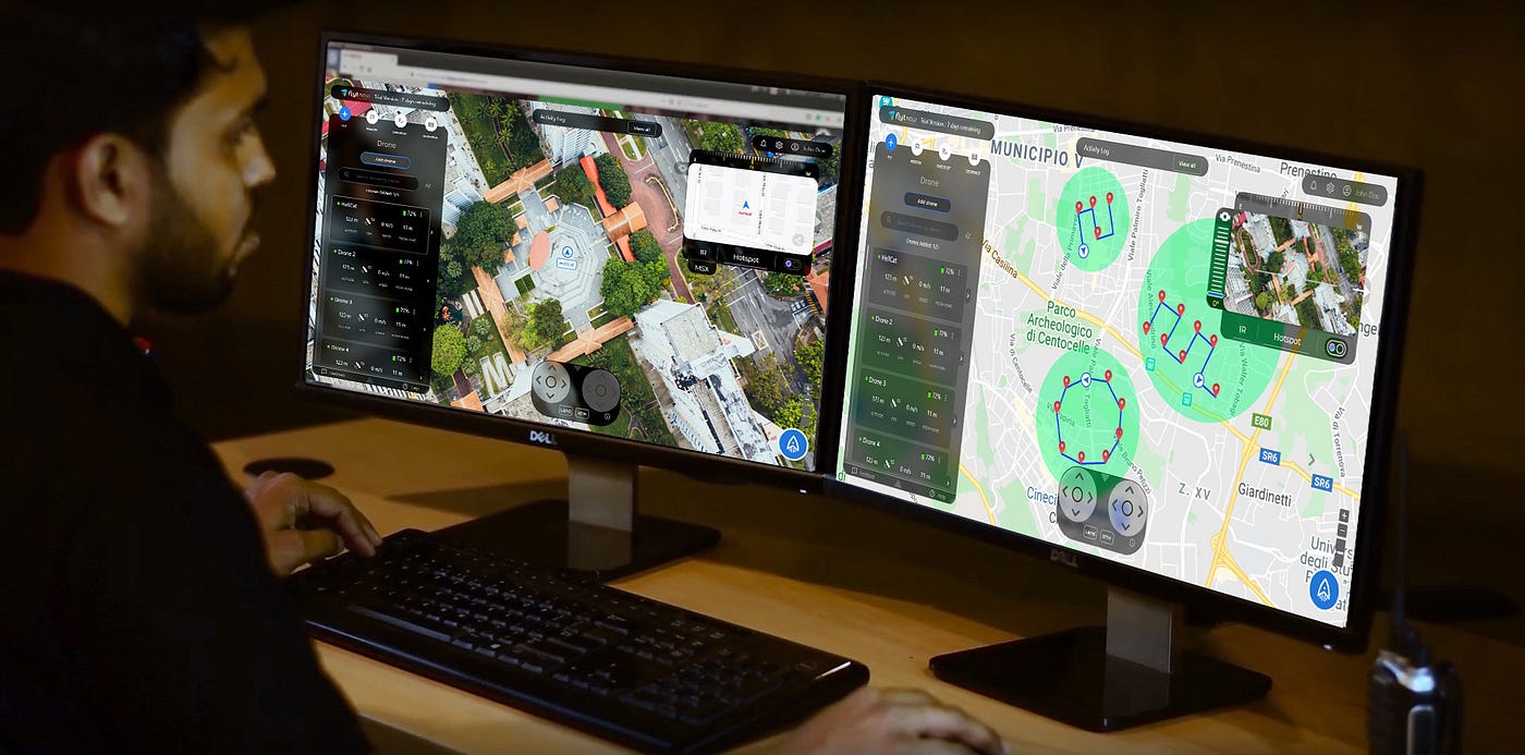
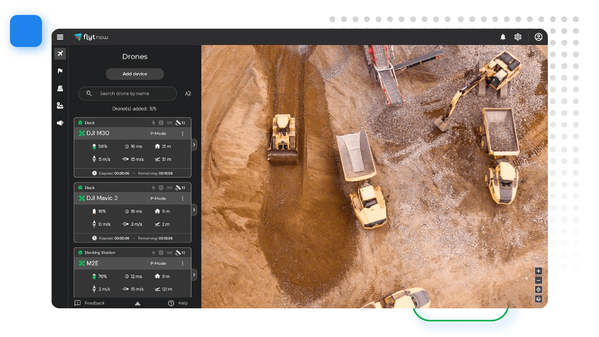
On the dashboard, you can add drones, create a flight mission, set up a pre-flight checklist, and define a geofence.

drone delivery operations

In the above screenshot, We have already added our drones and two of them are online. In your case, you have to add the drones. Follow our getting started guide to add your DJI drones.

Do not have a drone? Try FlytNow Pro with Virtual Drone. Follow Step 2

(Optional) Step 2: Adding a virtual drone.

Your free trial account supports up to five drones. In case you don’t have a drone, you can also add a virtual drone, you can add one virtual drone. For a virtual drone, you need to set up your FlytBase cloud APIs. Please follow this guide.

drone delivery software

Once granted access to the cloud, you can use your virtual drone’s vehicle ID and token to add it to the FlytNow dashboard.

Step 3: Creating a Mission Plan.

A mission plan lets you add a route for your drone. Considering you are testing a medical delivery system, you use the mission plan to define routes to all the medical centers you want to make deliveries.

To add a mission plan, click on Mission -> Add Mission. Give a name to your mission and click on Add Waypoints to begin defining your route. Clicking on the map will place a pin; this way you can place multiple pins.

drone delivery software solution

In the above screenshot, we have defined a mission that tells a drone how to go to Palo Alto Health Care. Apart from defining a route, you can set the flight speed and a Finish Action. The Finish Action tells a drone what to do once it reaches the destination; you can set the following actions.

  • Hover
  • Land
  • Return to Home

In our case, we have selected Return to Home that signifies that the drone will drop the payload and return to base.

Please note that FlytNow Pro offers limited features for mission planning. Advanced features are available in FlytNow Enterprise for Delivery.

Step 4: Creating a pre-flight checklist.

This feature allows you to create a pre-flight checklist. In the case of a delivery operation, a checklist will ensure that a drone is configured properly before it is sent out on a mission.

To create a checklist, click on CHECKLIST and then Add to Checklist to add a checklist item. While adding a checklist item, you can also add a description.

delivery drone software

software solution for drone delivery operations

We have created a checklist suited for drone delivery operations. You can create your own checklist.

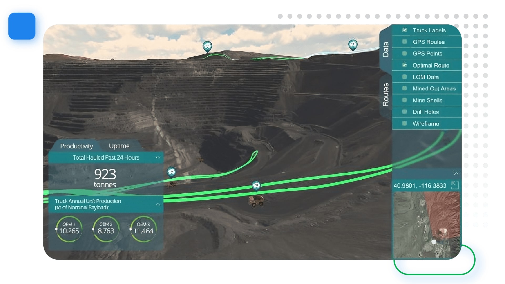
Step 5: Setting up a geofence

A geofence allows you to set up a boundary for your operations. Once you set a boundary, FlytNow will not allow your drones to fly beyond the boundary.

You can set up a geofence by:

  • Going to the GEOFENCE section in the FlytNow dashboard where you should be able to see your drones as a list.
  • Click on the edit option available in front of your drone name.
  • Enable the Geofence radius by clicking on the button.
  • Set the Geofence Values as per your safety requirements, i.e Height, and Radius.
  • The Height is restricted to 500 meters and radius is restricted to 8000 meters.
  • Click on the Save button after entering the values.

The following image shows you how your dashboard will look after geofence is set successfully.

A geofence has two circles. The area between the circles is called a warning zone. Whenever a drone crosses the first circle, the system gives out a warning, but it will not let the drone go beyond the second circle.

While planning a mission, you can’t put a waypoint beyond the first circle.

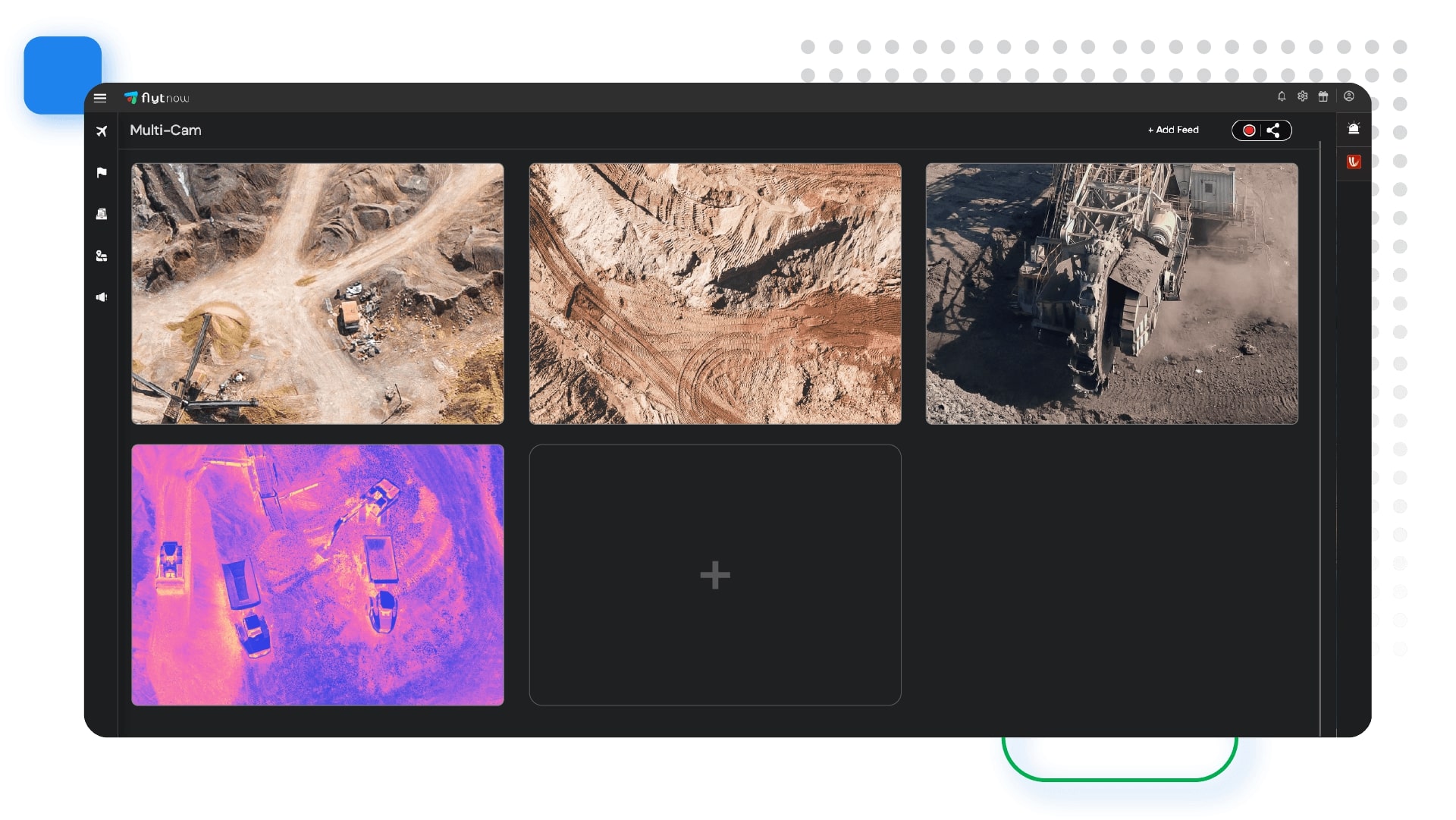
Step 6: Turn on Live video feed (feature works with a real drone only).

You can access the video feed of a drone from the dashboard. This feature is useful when a drone is out for delivery. This way you can visually assess a flight mission.

Select a drone under the FLY tab. Now you can see the video feed on the top right corner.

You can also enable the multi-cam mode (refer to the above picture) that will allow you to view the video feed from all drones on a single screen.

multi camera for delivery

Step 7: Share live drone location and video feed with a third party (feature works with a real drone only).

You can share live drone locations and video streams with anyone outside the FlytNow platform. This feature is useful especially when you want to share tracking information with a recipient which might include live video feed from the drone.

To initiate sharing click on the share button on the video panel

In the next dialog box click on Create new link.

Enter the email address of the person to whom you want to share the video.

Select the drones and your preferred options. You get the option to share both the map and the video.

The person with whom you have shared the live feed gets an email with a secure PIN. Tell him/her to click on View Operation and enter the secure PIN to start the live streaming.

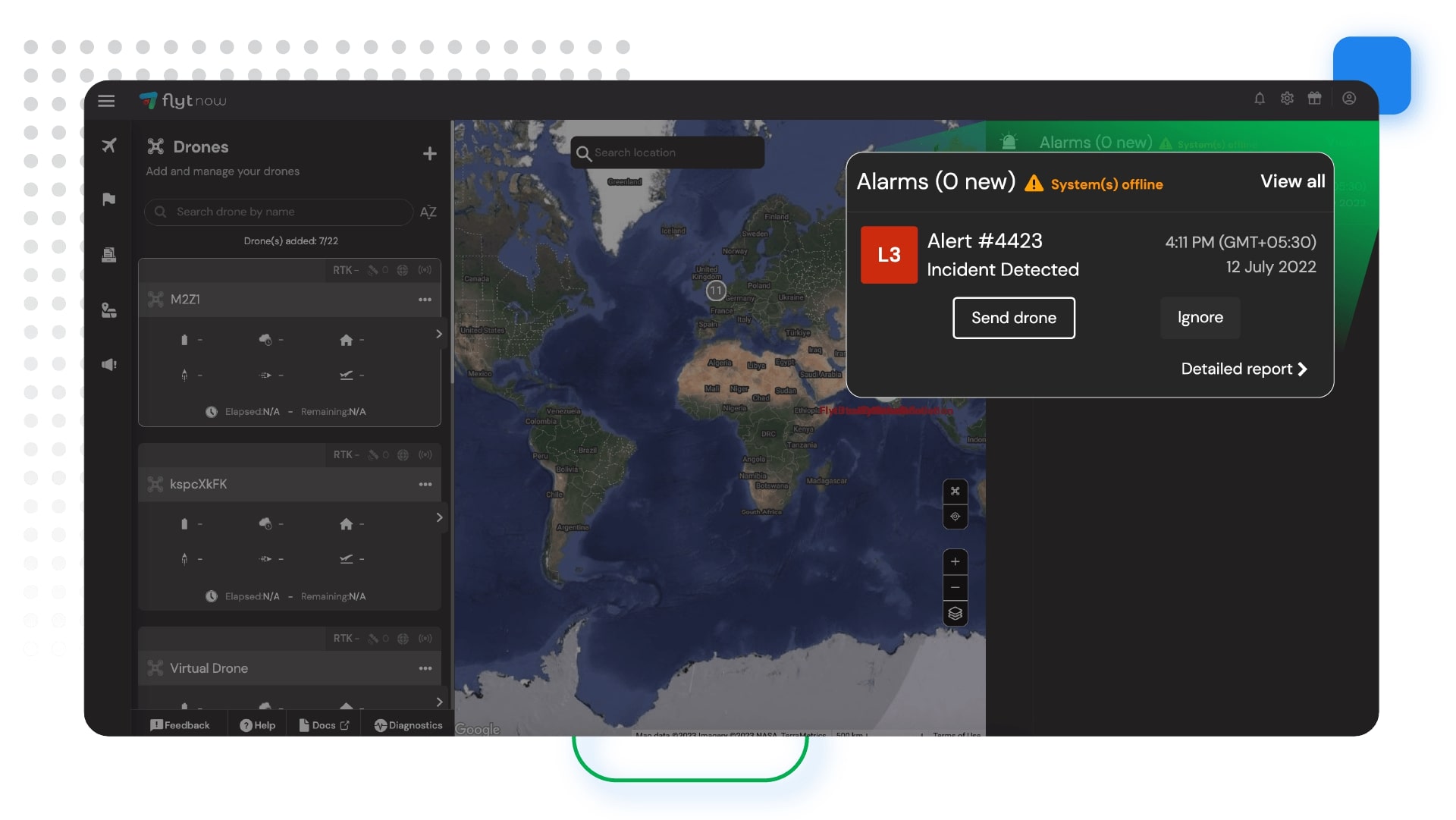
Initiating a Drone Delivery

Once you are done with the basic setup, it is time to launch your first delivery mission. Consider a situation where you have received a delivery request from a nearby medical center, and you are about to initiate a launch.

Step 1: Launching a drone and selecting a mission.

Under the FLY tab select a drone (has to be online) and click on the launch icon in the bottom right corner.

You will be asked to select a flight mode. Select Mission. In the next window, you will see all your missions. Select a mission and click on start.

Step 2: Completing the pre-flight checklist and executing the mission.

Next, you have to complete the pre-flight checklist.

Once you are done with the checklist, hit Execute to begin your delivery.

What’s the Next Step?

FlytNow Enterprise a Perfect Solution for Large Scale Drone Delivery Operations

We have been talking about FlytNow Pro which has limited features but ideal for validating an idea or doing a POC. Once you are done with the validation stage, it’s time to move to FlytNow Enterprise.

FlytNow Enterprise is a fully-featured comprehensive drone automation solution designed for large scale drone deployment. The solution is fully customizable and can be used in a variety of use cases, and drone delivery is one of them.

Here are some exclusive features of FlytNow Enterprise:

  • Add and manage multiple drones, operators, and clients.
  • Assign a drone to a delivery request.
  • Generate automatic, unlimited flight plan (straight line) from drone location to the delivery location, edit if required.
  • Control the gimbal, manually trigger RTH, and land for emergency situations.
  • Recording of video streams.
  • Set an advanced geofence - support of polygon geofence.
  • Integrate with third-party services like DroneLogbook and UTM like Airmap.
  • Integrate with Drone-in-a-box or charging pad like Skysense, WiBotic, Airscort.

For enterprise drones (DJI, PX4, Ardupilot), FlytNow provides SBC, with the FlytOS installed, for direct integration to make BVLOS flight possible over 4G/LTE/5G network. We also provide accessories and landing tag design for precision landing over charging pads.

drone in a box for security

--

Schedule a 30-min free consultation with our expert to learn more about the FlytNow Drone Delivery Software Solution, contact us at https://flytnow.com/contact/

Read more…

Drones with cameras have both commercial and recreational applications. For commercial use-cases, the ability to live stream videos, with low latency, is crucial for the effective use of drones. This enables enterprise stakeholders to see things happening far away, in near-real-time, from a bird’s eye view. Many industries, sectors, and use-cases can leverage such remote drone operations, for example:

  • Search & rescue
  • Surveillance and security
  • Monitoring and inspection
  • Public safety

A cloud-connected, user-friendly solution can thus be leveraged by drone operators, specialized service providers, UAV system integrators, and enterprise drone program managers.

Multi-Camera Streaming via FlytNow


The capability to stream videos from multiple drones, simultaneously, is now available in FlytNow, the remote drone operations solution from FlytBase. Multiple camera (‘Multi-Cam’) streams can be viewed from a single operator dashboard, which can also be used to control multiple drones, their payloads, camera gimbals, etc.

Top 3 Use Cases of Multi-Cam Streaming


While there are numerous commercial applications that can benefit from drone fleets and multiple-camera streaming capabilities, these 3 seem to be gaining the most traction.

Security & Surveillance


Automated drone patrols are at the heart of surveillance of residential, commercial, and industrial premises. With the FlytNow multi-cam feature, surveillance drone operators can cover large areas from a single dashboard; it allows them to gain situational awareness during a security breach, with the added advantage of images & video surveillance from different angles.

drone video surveillance

Security stakeholders can combine different views (eg. thermal and normal camera feeds) and be much more effective during night time, low visibility conditions, etc.

Asset Inspection


Drones are used to inspect infrastructural and other valuable assets that are remote, hard to reach, or massive in size. With FlytNow, inspection personnel can view such assets from multiple angles, with the videos streamed in real-time, from multiple drones to a single dashboard in the command center or control room. This ability is useful in a range of remote inspection activities such as structural inspections, wind turbine inspections, cell tower inspections, oil & gas refinery inspections, and pipeline inspections.

Structural Inspections

Aerial video surveillance

Large structures under construction require to be inspected quite regularly – this includes visual observations of foundations, roofs, and key structural components. The inspection data provide insights into the overall condition, progress, and maintenance needs of such properties.

aerial surveillance

The traditional way of inspecting, which involved manual inspection of only some of the areas of a large structure, is severely lacking – not only in coverage but also in terms of safety. Drone footage, on the other hand, can both improve coverage, reduce inspection time, and eliminate almost all safety concerns. Drone fleets powered by FlytNow can give stakeholders automated aerial views, from multiple angles, of important but hard-to-reach structural locations.

Wind Turbine Inspections

wind turbine inspection

Periodic inspections are an important part of the maintenance programs of wind-turbine sites, so as to maintain their efficiency, safety, and longevity. It’s important to check the structural integrity of the blades since different parts expand and contract differently under varying climatic conditions. Blades are also subject to damage from dirt, birds, snow, ice, etc.

wind turbine camera surveillance

Here, drones are now being used to rapidly, safely, and quickly scan the different parts of a wind turbine with highly calibrated IR sensors and high-resolution cameras. With FlytNow Enterprise, an inspector can capture different aerial views of a blade, control the camera gimbal remotely, and maintain a safe distance automatically.

Cell Tower Inspections

cell tower inspection using drones

Cell towers are tall structures that need periodic inspections to keep them operational and safe. Drone-based inspections can help significantly reduce the amount of time that people have to spend on a tower for such inspections. Safety, speed, and cost are all factors in making remote aerial inspections more amenable for broad adoption. Using FlytNow, live streams from drone fleets can be delivered to a single dashboard; these videos can then be shared with guest users, regulators, and other stakeholders in cell tower inspections.

drone surveillance operations

Refinery and Pipeline Inspections

oil and gas inspection

Drones are being designed and deployed for corrosion detection, analysis of cracks, spillage, and leak detection in oil and gas refineries and along long-distance pipelines. The information gathered by drone fleets can be invaluable for maintenance and planning at these complex facilities, with billions of dollars of infrastructure at stake. The speed with which inspection data is gathered can be drastically improved using multiple, autonomous drones, powered by multi-cam streaming available via FlytNow.

refinery and pipeline inspection

Public Safety


The biggest risk in public safety is to first responders, who have to be on-site without timely situational awareness. They also have to deploy fire trucks, ambulances, police cars, and other equipment – without first being able to assess the situation.

night vision drone

US-based technology company Phirst Technologies, which focuses on public safety solutions, has integrated autonomous drones into the CAD system that supports the 911 service. The idea is to dispatch drones from a unified dashboard to assess a situation before sending human responders. The solution is called FIRST iZ, and they are using FlytBase technology to power their drone automation.

Drones thus offer a compelling capability for incident response – public safety authorities can deploy them first, gain real-time awareness, and make better-informed decisions about people and equipment deployments.

Search and Rescue

disaster management using drones

Drones are actively used worldwide for search and rescue operations because they can cover a large area in less time while providing a bird’s-eye view. In 2018, police in the UK used drones to find a semiconscious man on the cliff of Exmouth; they used thermal imaging to locate and save the person.

These capabilities are now available in FlytNow so that search parties can quickly dispatch a fleet of drones and stream the live footage from them to a single dashboard, thus expediting the search and rescue process.

Firefighting

firefighting using drones

Drones fitted with IR sensors can find people trapped in difficult situations such as forest fires where visibility can be quite poor. In 2018, fires scorched more than 150,000 acres in less than two weeks in California. 16 teams of public safety officials clocked 500 drone flights in 3 days. UAV flight data was used to aid search and rescue operations, and pinpoint the path of the fire.

Since such operations may require scanning a very large area, of the order of hundreds of square miles, features like multi-cam streaming are crucial for the deployment of a large fleet of thermal drones.

Law Enforcement

drones for pandemic

During the COVID-19 pandemic of 2020, drones deployed in the city of Ahmedabad, India helped monitor lockdown and mitigate the spread of the deadly coronavirus. A central command center was established, with the FlytNow dashboard receiving live video streams from multiple drones flying across the city.

To get started with FlytNow visit our Get Started Guide.

or contact us at https://flytnow.com/contact

Read more…

5334390064?profile=original

Drone technology has witnessed a rapid maturity curve - with regards to not only hardware and software technology but also the use cases across industries and sectors. Consumer drones have gone past the typical use in film production and recreational uses. These prosumer off-the-shelf drones are now solving complex business problems - for example, in logistics, drones are being deployed to do last-mile delivery, managing inventory, and conducting security patrols.

In this blog, we will specifically focus on thermal imaging drones and the related use cases. Let’s start with an introduction to thermal imaging, understand how it works and how it might be used, via different drones and cameras, for commercial applications.

Need for Thermal Imaging

The ability to let people visualize what their eyes cannot, have led to the popularity of thermal cameras for conducting inspections and patrols. Owing to the invisible heat radiations emitted or reflected by all objects, such cameras record and produce an image of any object having a temperature above zero without the need for visible light. The hotter the object, the brighter it will appear in the thermal image (you can choose the color pallet accordingly).

Such differences in temperature of the objects under observation are then represented in different colors. Generally, blue shades are used to represent colder objects, while red shades are used to represent hotter ones.

night vision droneThermal imaging has therefore been known to offer superior protection in demanding conditions. Some of the prime benefits include:

  • Ability to remove blind spots
  • Capture data in low-light or at night time
  • Examine inaccessible areas
  • Ability to see-through camouflaging foliage

Recommended Thermal Cameras for Drones

Drones with thermal cameras have resulted in unparalleled flexibility for many businesses that require constant protection against potential intruders. Adding a thermal camera as a payload, allows operators to view thermograms in real-time, with the ability to immediately identify objects from the radiation emitted.

Some of the key factors to take into consideration while choosing an appropriate payload aligned for business include:

  1. Is the camera radiometric or non-radiometric?
    • A radiometric camera provides a temperature reading along with the thermal image.
  2. Does the camera come with a gimbal or a fixed mount?
    • A camera with a gimbal offers greater control to the operator over the camera movement.

Here are some recommended payloads:

flir drone camera

Popular Drones used for Thermal Imaging

Apart from having a fast turn-around time, drones are pocket-friendly as compared to installing thermographic cameras at several locations in the property with a higher possibility of blind spots. Some of the cost-effective drones that could quickly cover the entire facility and be used 24x7 for monitoring include:

Use Cases of Thermal Imaging Drones

Aerial imagery is the primary application of commercial drones; with a thermographic camera, drones can further add value for various enterprise applications.

thermal imaging camera for drone

More recently, during the outbreak of COVID-19, thermal cameras were widely used by the public safety authorities in many countries to detect infected people by checking body temperatures. Thermal drones were also used to identify people defying lockdown rules or social distancing guidelines imposed by many countries especially at night.

Why use FlytNow for Automated Night Surveillance

FlytNow Enterprise for Security and Surveillance enables drone operators, service providers, and enterprises to remotely operate a fleet of thermal drones.

An ideal solution due to the following capabilities:

  1. FlytNow provides geofencing and intelligent waypoint design that a security service provider can use to schedule patrols. The geofencing feature creates a virtual boundary for your drones. The platform allows the creation of unlimited flight plans and streaming of live telemetry to further aid such operations. drone automation
  2. The cloud-based platform provides live, low-latency streaming of thermal video from multiple drones on a single dashboard, which can be used to inspect a structure or situation from multiple angles and viewpoints.infrared drone
    An operator can remotely control the camera gimbal of drones connected to the FlytNow system, and thus effectively track different objects on the ground. With the AI detection feature, FlytNow allows the auto-identification of objects and humans.night vision drone
  3. With FlytNow, one can share a live video feed with anyone using an URL, including the map view. This way, a FlytNow user can share his screen with someone who doesn’t use the platform.
  4. FlytNow provides integration with Airmap and DroneLogbook so users can scale their BVLOS flights.
  5. FlytNow integrates with Skysense charging pads so users can completely automate the launch, operate, and docking cycle of a drone. It also supports precision landing so drones can land on charging pads.

Here is an illustration of what drones with thermal imaging working at scale might look like.

drone with thermal camera

---

To get started with FlytNow visit: https://flytnow.com/getting-started-with-FlytNow/

or contact us at https://flytnow.com/contact

Read more…

1*vzCTm8Xbdt_Cf4xvQihp7g.jpeg?profile=RESIZE_710x

Observational surveillance systems rely on the capabilities of the cameras employed, but the main limiting factor is the stationary nature of the cameras in a traditional surveillance system. Now, surveillance can be achieved utilizing drones; it can be not only cost-effective but also accomplish the desired outcome more safely, efficiently and at a much larger scale. Security drones present a quicker, more economical method of aerial information collection.

Drone operations for the purpose of surveillance and security can now be automated using the FlytNow solution from FlytBase.

Benefits of Using Drones for Surveillance

Here are some of the benefits of using drones for surveillance.

  • Security drones can reach confined and narrow spaces. They can be outfitted with detectors and night vision cameras, giving them a superior vision that can detect things that a human eye cannot.

Use Cases for Surveillance Drones

Intruder Detection

0*uWBLlEI3s6GZgWQe?profile=RESIZE_710x

A drone security system can be deployed for home security or monitoring commercial properties. They can relay live video footage, eliminate blind spots both during the day and nighttime — and follow and track trespassers and intruders, thus reducing the chance of theft.

Traffic Management

0*88t7SryvdDiSaR1r?profile=RESIZE_710x

Drone surveillance can aid in real-time traffic control. They can improve situational awareness during accidents. Drones can employ analytics in traffic management that includes automatic vehicle count recognition, license plate identification, and tracking vehicular activities for improved safety and security.

Wildlife Protection

0*0LxpY1_08RJ8REEK?profile=RESIZE_710x

Forest officials face a constant threat of poachers hunting. Drones outfitted with thermal devices can replace stationary IR systems that are costly and not as effective. Surveillance drones have a fast turnaround time; they can be deployed on-demand and controlled from a base station.

Safeguarding Perimeters

0*JyW32GSCWma-CKJe?profile=RESIZE_710x

Commercial and residential properties usually have pre-defined boundaries. Surveillance drones can track a target area from a safe distance with live updates of possible threats present at/inside the perimeter. Surveillance drones can operate even at night time with the help of IR sensors, thus avoiding harm to security guards and serving as ‘eyes in the sky’.

Crowd Management


0*qKYCCkUm643AtLxN?profile=RESIZE_710x

The government can track large scale events and execute complex analytics like head-count evaluation, riot detection, and identification of law-breakers. Drones armed with speakers and beacons may be used for crowd control.

Protecting Borders

0*wHAbDP3YGIenxGcW?profile=RESIZE_710x

Surveillance drones can be used to monitor insecure border operations and dangerous zones. They can give live video feeds to security officials and other stakeholders, thus enabling them to make strategic decisions from safety.

FlytNow Enables Surveillance with Drones

FlytNow is a cloud-based, remote drone operations software that can be used to manage a fleet of drones from a single, user-friendly dashboard. The platform has intelligent features like geofencing, flight path design, precision landing, autonomous charging, collision avoidance, etc. that can be used for automating surveillance activities with drones.

The FlytNow dashboard is the command center from where operators can control multiple drones, which in turn are connected via 4G/LTE/5G. Users can stream live videos from the entire fleet of drones on a single dashboard, and can easily switch between map mode or video mode.


The FlytNow solution also integrates with the Drone-in-a-Box technology allowing enterprise users to completely automate the flight, patrol and docking cycle of a drone.

0*X01CyOmD8KtY3aGa.png?profile=RESIZE_710x


How can drones be easily, quickly adopted for security use-cases?

FlytBase offers a 28-day free trial for users to explore FlytNow Pro edition and its relevance to specific use-cases for security stakeholders. Customers can add their drone fleets, fly them autonomously, create flight plans & coordinate missions, set geo-fence and checklists, view and store live video footage and integrate drone operations into an existing system.

To get started with FlytNow visit: https://flytnow.com/getting-started-with-flytnow/

Read more…