
Here is the article in the Guardian newspaper:
Read and scroll down for the fear mongering comments.
Here is the article in the Guardian newspaper:
Read and scroll down for the fear mongering comments.
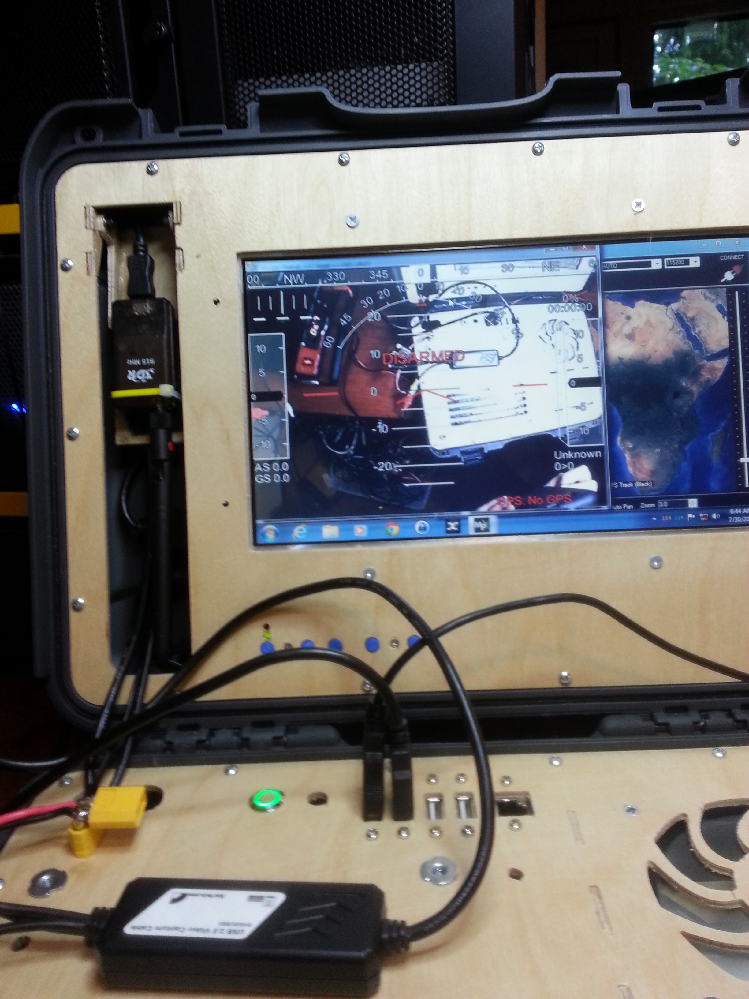
Hey everyone,
I have to admit, I am a little fed up with the "ground stations" available on the market today. First off, good luck seeing most laptops or tablets at all outdoors. Second, good luck modifying or repairing your laptop / tablet. It can be done but its usually a major pain with a good chance of breaking something.


I used a nanok 910 for the outer case.The techstation features a 10.1 inch display from Pixel Qi. What makes it so special is that it changes from a bright, normal LCD display to a reflective, E-paper like grayscale display, like above, that actually becomes more visible with ambient light. I Combined the screen with a Gigabyte GA-E350n motherboard. for only ~$75 you get a motherboard and embedded AMD E-350D APU with Radeon HD 6310 graphics. Together with 8 GB ram and a 120 GB SSD, There is plenty of power to run mission planner and a USB video frame grabber. All while only drawing about 2.5 amps@ 12v.

The power supply is The M-4ATX from mini-box . It accepts power from any unregulated 30-6 V dc source. It also provides reverse current and over voltage protection.

For a complete screen solution I used the screen and LVDS driver combo from Adafruit. The driver board gets power from the 12v accessory line coming from the M-4ATX so it is protected as well
 You can access different inputs to the screen here. It even has a direct RCA jack for video display.
 You can even tell your significant other it is a new media center for the family. It streams 1080p movies!
 If that fails Just say "I got it for the kids"
The plan is to provide a simple DIY solution it the form of a kit consisting of the mounting plates, hardware and front panel connectors so you can build one yourself on the cheap. the kits will be somewhere around $50 -$100. You will need to provide:
Mini ITX motherboard/cpu/gpu/ram
SSD
10 inch LCD screen preferably this
I saw this Raspberry Pi clone today the first time and will definitely try it in september. A lighter, smaller alternative to the rpi.
From the description:
ODROID-W is a miniature computing module which is fully compatible with all software available for the Raspberry-Pi.
The W stands for: - Wearable device development
- Widely applicable Internet of Things (IoT) development
- Workable DIY electronics prototyping
http://www.hardkernel.com/main/produc...
I thought this was pretty cute, well done to boot
Shooting by the company Photos aériennes / post processing and 3D printing by Drones Imaging.
This photorealistic and geographically accurate 3D model was obtained using Correlator 3D software and printed with our Formlab. The technology of our 3D printer is based on the laser and solidification of resins designed for reliable printing with a very high level of accuracy.
http://www.dronesimaging.com/en/photogrammetry-3d-printing-of-an-open-quarry/

Hello,
it is my pleasure to announce today that we have launched our campaign on Indiegogo platform.
INDIEGOGO: www.indiegogo.com/projects/ap-manager/
Here you will find further technical details and an information video for the product.
For the fast decision makers, we have a limited "Early Bird" series provided.
I am pleased with your support for the project.
With very best regards from Linz, Austria.
Robert Hoermann
and the entire Team GIZMOtec
"A nippy microkernel mathematically proven to be bug free*, and used to protect drones from hacking, will be released as open source tomorrow."
Has anyone heard about or seen this? How applicable is this to the Pixhawk, Pi or BeagleBone flight controller efforts? The best bit is that it seems to assure that all user mode code execution is isolated from the Kernel in such a way as to prevent crashing the kernel. I don't think this actually prevents bad FC code but it sounds like it could be a step in the right direction surely.
Without reading too much into this I did note that in the video they seem to say that the software "detects" malicious groundstations by monitoring for those that attempt to authenticate with the wrong password too many times. They also said that the GCS link was encrypted. I think what they actually mean is that their software overlays encryption to MAV connections and the FC detects attempts to communicate over unencrypted links. I'd hate for this to be another WEP style weak cipher that encrypts with a shared key or worse still some kind of authenticated SSL style link using a password based challenge response in each conversation
More details here
New product, seems fine to making mapping, but don't know the cost, and whats the advantages/disadvantages comparing to https://www.kickstarter.com/projects/swiftnav/piksi-the-rtk-gps-receiver
The standard V-Map system now features the following components and functionalities:
L1/L2 GPS phase measurements recorded on board at 20Hz
Power input ranging from 5V to 36V
LED indicator to monitor satellite reception
LED indicator to monitor proper data storage
Event marker port
One PPS outputs
Removable micro SD card for data retrieval
Dual frequency helix antenna
The weight of the receiver excluding external cables and antenna is 120g.
V-MAP- PDF (http://www.microaerialprojects.com/wp-content/uploads/2014/07/The-20Hz-V-Map-System-Jul14.pdf)

Started a little pet project as I further develop a flight system that we can use on all of my crafts. This was going to include a uniform setup for several pieces that made the system work for me. I wanted to include a head tracker,as I started getting into this I remembered a episode that I liked very much on Top Gear, yes I am a gear-head also. So as I thought more about it,a nd as I get this setup consistent across the fleet this would be a good time to question how to set that up.
The episode had evolution of controls for the automobile and started to think about some of the ways we control quads, How they are controlled, what those controls were derived from and if improvement could be made because so many features that drones especially multicopters can do never really existed, especially not when the first RC controller was made. yes they are functional, however anyone who has flown with lots of options probably can relate to feeling like their are allot of controls to think about.
This made me think, I know that is not a thing that a human cannot do without tools but if I were to fly, what would be the most intuitive interface? I am not going to digress and list all the things I looked at in doing the research as some are very obscure. For example a Anime series I watched with my son called Sword Art Online or SAO. this really got into what it would be to fly in a virtual environment and how it would be controlled as intuitively as possible.

I quickly felt that if I wanted to use a head tracker that allows for 3 axis input I felt that that would be better for my flight control, while throttle could be be controlled by gestured movements. We have participated in several different development programs using Vibromyology (the study on muscles and the vibrations they make when the synapse fires). One unit we have in the lab is by Sonostics, they have a product called Myowave, and it can tell me how much force the muscle is giving in contrast to how are you try to use the muscle. Another product the Myo Arm band from a company named Thamic labs(no relation to Sonostics, Myowave), we are involved as a third party developer and as you watch the video below:
it is easy to see now how this "Superman" mode could be used. Then I felt that if we use a eye tracker this could then be used if you have a Gimbal or pan tilt on board for the cam to look around.
So my next steps:
As we continue to develop our solution for OSD and a hybrid Analog/Digital FPV that is better integrated into the on-board flight controller, stream line the tx/rx bands used to send all the information back and forth I will be taking my own deviation on this "Superman" Flight mode.
As progress is made I will be sure to post the updates.
before someone comments and says something about it, yes I have seen the video below, but I want to fly like superman, I could careless if my craft looks like him...
A map represents areas where it is not recommended to fly drones due to regulations.

As reported from their website, seems like a great upgrade for the telemetry radio, maybe to also carry RC control, and depending on bandwidth maybe using it also for a digital video feed.
It is on indiegogo
https://www.indiegogo.com/projects/xrange-extreme-long-range-wireless-module-for-868-915-mhz
As listed on their site:

It is a wireless electronics development platform that provides extreme long range spread spectrum communication and has over 12km (7 miles) of usable range.
XRange is based on the SX1272 LoRa™ long range modem, low-power ARM micro-controller and powerful switching power supply.
For more information about sx1272
For more information about STM32L152
Dimensions 78 mm x 42 mm


We are working to provide open source libraries and firmware.
“The mbed development platform is the fastest way to create products based on ARM microcontrollers.”
We are working to provide libraries and firmware based on Mbed platform.
Mbed already provides driver for sx1272.

Keil MDKWe have developed libraries and firmware based on Keil MDK platform.
Check out this cool new Droneshare feature, out in beta (beta.droneshare.com): No-Fly Zones! Just select the "Restricted Areas" view from the little icon at the top right of the map (this is only in beta.droneshare.com now, but will be in regular droneshare.com soon). This is thanks to our friends at Mapbox, whose mapping API we use in Droneshare.
Here's the Mapbox post explaining the feature:
Unmanned drones like quadcopters and fixed-wing aircraft are at the center of new airspace regulations by the FAA. While the FAA deliberates on rules and regulations, states, cities and other national organizations have implemented their own no-fly zones. To help people find safe places to fly, we’ve mapped established no-fly areas where drones are not permitted around all major airports, military bases, and national parks across the country. All the no-fly area data we collected to make these maps is now open data under CC-0. Go explore the map
Red denotes no fly zones. Explore the map
Where can you fly a drone?
We’ve constructed a map that shows drone pilots restricted airspace. Currently, the 3 no fly zones are:
- US National Parks
- US Military Bases
- 5 mile radius around medium to large size airports
For example here is a look around New York City and Northern California.
No fly zones in greater New York City area. Explore the map
No fly zones in northern California Explore the map
This map is a just a start - if you’d like to add a source to the map, submit your feedback here. There are still many uncertainties around where and how one can fly a remotely operated aircraft. To find out more about local aircrafts restrictions and lean safety tips, contact your local aviation club before flying. We have also started a public Github repository for anyone to post other no-fly zones.
You can also embed the interactive map on your website:
<iframe src="https://www.mapbox.com/drone/no-fly/?embed=true#5/38.651/-96.504" frameborder="0" width="100%" height="400px"></iframe>.Find me on Twitter (@bobws) if you’d like to talk more about drones or ping @amyleew to talk about using this open data to make your own maps.
From Politico
President Barack Obama plans to issue an executive order to develop privacy guidelines for commercial drones operating in U.S. airspace, POLITICO has learned.
The order would put the National Telecommunications and Information Administration, an arm of the Commerce Department, in charge of developing the guidelines. NTIA would bring together companies and consumer groups to hammer out a series of voluntary best practices for unmanned aerial vehicles.
The FAA, which is working on a formal set of rules to allow commercial drones to operate in U.S. skies, has been criticized for not tackling issues around what kind of images and data drones can collect. Consumer groups and some lawmakers have said drones could violate people’s privacy by peering into their homes and backyards.
It’s not clear when the president will issue the order. White House officials declined to comment, but confirmed government-wide efforts to coordinate policy on the issue.
“We don’t have any details to share at this time, but there is an inter-agency process underway,” said White House spokesman Ned Price.
FAA didn’t immediately respond to a request for comment.
The FAA has said it will issue a rule on small commercial drone use by the end of the year. Congress set a September 2015 deadline for the agency to safely integrate drones into the nation’s airspace, though an inspector general’s report earlier this year cast doubt on the agency’s ability to meet that timeline.
The NTIA process will not address government use of drones, though more than a dozen states have put limits on how law enforcement can use the technology, often requiring a warrant and data deletion after a certain period of time. This year, a number of state legislatures began considering additional laws aimed at curbing private-sector drone use.
NTIA has experience with privacy issues in the tech sector. The agency convened meetings to work out industry codes of conduct for mobile apps and is now doing the same for facial recognition technology.
From free spirits to regulated r/c:
http://88nv.burningman.com/drones-rc/
Introduction:
The rising popularity of remote control (RC) aircraft including: fixed wing planes, helicopters, multicopters aka “drones” or unmanned aerial vehicles, presents many challenges at the Burning Man event. Black Rock City, LLC’s (BRC’s) mission is for RC activity to proceed in the safest manner possible, while also respecting the privacy rights of participants.
Like mutant vehicles, BRC regulates all RC aircraft and requires that they be operated responsibly, and subject to restricted fly zones and other rules of operation. BRC has an established RC community, which has stepped forward to collaborate on creating rules and recommendations based upon The Federal Aviation Administration (FAA) regulations and the Academy of Model Aeronautics (AMA) safety code.
The FAA requires all operators of RC aircraft flying within 5 miles of an airport to notify that airport of their operations. Virtually all of Black Rock City is within 5 miles of 88NV, Black Rock City Municipal Airport. So, all RC operators must register and follow all policies, rules, restrictions and conditions stated in this document and communicated at the Event in RCBRC briefings.
Restrictions include, but are not limited to:
- Flying sufficient distance away from populated (city blocks, theme camps, etc.), low noise tolerance (the Temple!) or other sensitive areas (including Burns and the Man)
- Avoid flying near spectators until aircraft tested/flown previously.
- Flying no higher than 400 feet above ground.
- If within 5 miles of an airport: notification of the airport operator. (Registration satisfies this requirement.)
- Avoid flying in proximity of, and give right-of-way to, full-scale aircraft.
Rules of Operation
- Maximum altitude allowed per FAA is 400 feet above ground.
- Only visual line of sight flying per FAA, no long distance flying.
- No First Person View flying (flying based upon video stream not direct sight).
- Secure a safe place to take off, land, and emergency land.
- Fly when possible with a spotter to help control on-lookers, etc.
- Keep 100 feet horizontal separation away from all perimeter fences / trash fence.
- Keep 100 feet horizontal separation away from EMS, Police, Fire Department vehicles and their camp locations.
- Keep 100 feet horizontal separation away from all heavy equipment and work crews.
- Keep 100 feet horizontal separation away from all ground vehicles, artwork, sculptures, guidewires, kites, tethered aviation, etc.
- Avoid flying over or close to people, AMA recommendations are horizontal separation of 25 feet at least.
- Immediately land if skydivers are seen overhead. You may resume flight after they have landed.
- No operating RC aircraft while intoxicated. If you are deemed intoxicated to the point that you are “illegal to drive” you may not fly.
- No use of ham bands including 433, 600, 900 MHz and 1.3 GHz unless a current Technician, General, or Amateur Extra License is shown.
- No amplified systems, for example: Dragonlink.
- If a pilot is acting in an unsafe manner either law enforcement or the Black Rock Rangers have the authority to confiscate the controller/transmitter and transfer it to Lost and Found and RCBRC notified.
- If a crashed craft is found it will be transferred to Lost and Found and RCBRC notified.
- Aircraft confiscated for flying unsafely, recklessly or in violation of rules will be held at Lost and Found until the end of the event or the participant/pilot permanently departs from the event.
- Unclaimed aircraft will be subject to ordinary Lost & Found procedures of Black Rock City via Playa Info. BRC is not responsible for unclaimed aircraft.
Flying Prohibited During The Following Conditions
- During strong winds
- During dust storms
- Inside of or from the top/side of any architecture/structures
- From a moving vehicle
- Hovering over people, personal living space (tents, RVs, shower stalls, fenced off camps, etc).
- Night flights must have adequate navigation lights per AMA rules.
Flying Prohibited At The Following Locations
- Entry and exit roads leading into BRC
- Center camp
- Esplanade
- Inside The Man safety ring
- The Man after it closes for pyrotechnical set-up
- Temple Burn
- Airport restrictions (see below)
- Incident Command (Law Enforcement & Emergency Services Area)
No Flying At Or Near BRC Municipal Airport (88NV)
- No flying at 88NV including the 88NV camping area, terminal, ramp/tie-down, and runways unless direct face-to-face permission is given by the Air Commander, Airport Safety Officer, or Runway Manager during airport operation hours (dawn-twilight).
- No flying from the last named street that surrounds BRC over walk-in campground to the trash fence/perimeter from the radials of 2:00 to 6:00 (dependent upon location of airport being at 5:00 or 5:30) during airport operation hours (dawn-twilight) unless direct face-to-face permission is given by the Air Commander, Airport Safety Officer, or Runway Manager.
Other Conditions
Please be aware that there are other rules and laws that may affect operations of an RC aircraft. For example, using an RC aircraft to photograph or videotape someone without their permission or for commercial purposes is not authorized under BRC’s Ticket Terms and Conditions. Intentionally or negligently injuring persons or property with an RC aircraft could lead to criminal assault and or battery charges. Interfering with airport operations is a federal crime. Be mindful of all laws, rules and regulations when operating an RC aircraft, and use common sense. If RC aircraft are operated unsafely then they will be subject to further regulation and restrictions in the future. Help make BRC a place where RC aircraft are a valued part of the community.
Registration:
- Registration is mandatory and on-line pre-registration is highly encouraged; registration will be limited to the first 200 participants.
- On-playa briefing, completed pre-registration form and craft registration is required.
- Registration constitutes participant’s agreement to abide by all RCBRC policies and rules and to be financially responsible for any harm or damage pilot or RC aircraft/drone may cause during the Burning Man Event.
- Burning Man has the right to confiscate RC aircraft/drone found to be in violation of any RCBRC, FAA, or AMA policy, rules or guidelines.
- Aircraft confiscated for lack of registration will be held at Lost and Found until registration is presented.
- Aircraft confiscated for flying unsafely, recklessly or in violation of rules will be held at Lost and Found until the end of the event or the participant/pilot permanently departs from the event.
Unclaimed aircraft will be subject to ordinary Lost & Found procedures of Black Rock City via Playa Info. BRC is not responsible for unclaimed aircraft.
REFERENCES / LINKS
Academy of Model Aeronautics website: http://www.modelaircraft.org/
Academy of Model Aeronautics Safety Code: http://www.modelaircraft.org/files/105.pdf
Remote Control Aerial Photography Association RCAPA Recommended Operational Guidelines http://rcapa.net/guidelines
We're very much obliged to Billy Bargagliotti of Memphis, Tennessee, for putting together an X-Plane model of our Vulture 2 spaceplane.
It's a work in progress, but advanced enough to give a flavour of how the aircraft handles, and indeed just what happens when you fire the rocket motor. Entertaining stuff.
As is obligatory with any High Altitude Ballooning (HAB) mission, magnetic trees have proved an irresistible attraction for the Vulture during the first few test flights. Here's an attempted manual landing just before arboreal intervention:
Suffice it say, we've moved future flights to the desert. There's more on Billy and the X-Plane Vulture 2 here.
Gizmag reports on the launch of a new Kickstarter project that uses quadcopter design to lift humans. (me, I think if men were meant to fly they'd have wings. That's what robots are for!)
Having revealed its original Hoverbike design back in 2011, Malloy Aeronautics has been hard at work developing its ambitious, science fiction-inspired vehicle. The team has made some significant changes in the last few years, moving from a dual rotor to quad rotor design while adding some serious stability credentials in the process. Chris Malloy has now launched a crowdfunding campaign on Kickstarter where backers are being offered a working one third scale version of the second-generation Hoverbike, while giving the team a helping hand in the development of the eventual, manned vehicle.
The hoverbike has been a staple of science fiction for decades, but it’s only in recent years that the concept has started to take tangible steps into reality. The team’s original Hoverbike design, revealed back in 2011, boasted some impressive stats, including the ability to theoretically reach speeds of up to 150 knots (278 km/h or 173 mph) and altitudes of 10,000 ft (3,048 m) and beyond.
With its new design, the one third scale drone version of the vehicle is impressively stable and is even able to carry a glass of water without spilling. The scaled down version of the vehicle, which acts as a proof of concept for the full-sized Hoverbike, packs a 3DR Pixhawk flight controller and is capable of following a pre-determined flight path, following the pilot, and can even perform automatic take-off and landing maneuvers.
The drone is 1,155 mm (45.5 in) in length, constructed from aircraft grade aluminum, carbon composite and polyurethane, and capable of carrying a recommended payload of 1.5 kg (3.3 lb). The quadcopter itself weighs in at 2.2 kg (4.85 lbs), and can travel at speeds of up to 45 mph (72 km/h). Its flight time is determined by the weight of its payload.
The scaled down version of the Hoverbike also has an advantage over other consumer quadcopters in that it folds down to a more manageable 590 mm (23.2 in) length. You can even purchase a purpose designed backpack from Malloy Aeronautics for transportation. Pledges for the fully functional drone start at £715 (US$1,219), with shipping expected to start three to four months following the conclusion of a successful Kickstarter project.
One last thing that makes the miniature hoverbike an even more appealing prospect is the so-called Cyborg Buster one third scale human model that is available as a CAD design and ready for home 3D printing. The semi-articulated figure is designed to mimic a human pilot, and there’s even a purpose-designed space in the head for a Go-Pro camera.
While the tangible reward of your very own Hoverbike quadcopter might be enough to make you shell out and support the crowdfunding campaign, the final goal of the project is a little grander. After years of development, the team at Malloy Aeronautics arrived at the current quad rotor design and is now working towards the construction of a final engineering prototype for submission to aviation certification authorities. The team plans to use the funds provided by Kickstarter backers to make this a reality and will continue work until the eventual manned Hoverbike is available for sale.
Once the full size vehicle is operational, the team envisages that it will be used for more than just recreation, highlighting uses including cattle mustering, cargo insertion (up to 120 kg/265 lb) and perhaps most notably, search and rescue operations. The fact that the vehicle can be folded down to a third of its length makes it easy to transport, and its precision controls should make it ideal for dealing with difficult terrain such as that associated with ski and mountain rescues.
More information is available in the pitch video below.
Sources: Malloy Aeronautics, Kickstarter
Forbes reports on the launch of this new organization.
If you are involved at all in small drone flying, you are likely to have come across Peter Sachs in one of a number of online forums dedicated to unmanned aerial vehicles or have visited his website to learn from an expert the latest in drone law. He’s a commercial helicopter pilot, aviation attorney and drone enthusiast. He is also the publisher of dronelawjournal.com – an online legal reference for the latest in drone law affecting small unmanned aerial vehicles.
He tweets under the name TheDroneGuy, frequently jabbing the FAA for what he – and many legal experts I have spoken with – consider to be unfounded legal interpretations and enforcement actions against drone operators, including the infamous case against Rafael Pirker. Recently, the FAA had the dubious distinction of winning a case brought by the search and rescue organization Texas Equusearch, whose search and rescue missions had been grounded by a cease-and-desist order issued by an FAA inspector.
The basis for the FAA’s “victory”? The Court of Appeals’ determined that the cease-and-desist order itself was legally unenforceable, stating “the challenged email communication from a Federal Aviation Administration employee did not represent the consummation of the agency’s decisionmaking process, nor did it give rise to any legal consequences. ”
And now, Peter Sachs’s latest venture is starting the Drone Pilots Association to “represent the interests of all commercial and non-hobbyist drone pilots.” For now, membership is free. [Full disclosure, I have been asked to be on the advisory board for the new organization.] Launched late last night, the website quickly garnered more than 100 members.
As I have written before, I believe that the United States is falling further and further behind other countries in adopting and utilizing the commercial promise of this exciting new technology. And missing out on the thousands and thousands of jobs that could be created across the country. Japan, Canada and Australia are among the countries that have moved much further ahead in allowing use of drone technology to advance agricultural and scientific research.
While as a long-time safety advocate, I agree that integration of manned and unmanned aircraft requires a deliberate process, I believe that the FAA could safely allow the commercial use of small UAVs (for example, those under five pounds) by managing their operating procedures to avoid populated areas and areas where manned aircraft fly. I look forward to serving on the Advisory Board of this new organization.
Encouraged by the success of my previous custom board (Version 2), which happily carries my quad in the air (maiden flight) with some advanced features like self-stabilization, course lock, control loop operating at 400 Hz, etc., I decided to jump on a more ambitious project - the board with more sensors, more ports, etc.
In summary, the new board (Version 3) has the following parameters:
Here is the board overview (above)
I will be documenting every step of developing (mostly - porting from V2) firmware for this boards as well as sensors' calibration on my blog. Obviously, all the code is Open Source under the MIT License located in the SVN repository.
With so many unemployed programmers, it was only a matter of time before someone would try to free the bits & upload some videos. We'll see how long this lasts until the indy movie studios crush the rebellion. These videos covered what currently are the 3 mane copters, in a rare appearance without any editing.
Collinn was a lot more down to Earth than when we was at DJI. It was still definitely a choreographed team demo, looking a lot like a Vegas trade show.
As with personal experience, the 1st attempt at a programmed flight was a hair raising flyaway & it took 2 attempts for it to work. He assumed it was a conversion from centimeters to meters, but the team never said what it was. When it did work, the droidplanner eye candy obscured what was happening, but you could barely see that it wasn't able to fly in a circle, in the wind.
They may have removed the circle from the flight plan because it wouldn't work. The user interface never showed it.
The eye candy made Droidplanner worthless outdoors, but it did show the potential for easy mission planning. It just needs a way to play back a simulation before flying, in order to avoid take 2.
Mark was quite a contrast to Colinn. He expounded so much, he ran out of time & wasn't allowed to show his Lightbridge system. Both these videos were manely manually flown, as it's been during any fly-in. For all the hype, the latest autopilots & sensors just aren't fluid enough to compare to manual control, especially in the wind. It also seemed to take the DJI's too long to get a GPS lock to be practical. They need to install the backup battery in their uBloxes that Pixhawk uses in its uBloxes. So the autopilot is still rarely used, even in a product demo.
He mentioned the robustness of his diversity video system, but when actually flown, the quality was worthless.
The Phantom Vision was a piece of work. DJI is still the only one offering a fully integrated camera/copter system with the video controls & flying controls together, digital video downlink, & a standardized RC control. While all the video downlinks were horrendous, the downlink from the digital DJI system was lightyears ahead of the others.
The lowly Phantom Vision made the Iris look pretty crusty, with the team having to explain to Colinn how the jiggered RC controller was configured, the user being required to configure the camera the ages old way by hand, the user having to supply an ages old glitchy analog downlink. As much as customization can be desirable, the integration is why the Phantoms are everywhere. 3D Robotics just needs to start hiring people.
Finally, we have 1 of the DJI octocopters of stadium crash fame. This was the only demo which was manely flown on autopilot, but he was focused on still photos more than video.
The DJIs were flown in autopilot stabilized mode a lot more than the Pixhawks, as it tends to be in every video featuring DJI. Their autopilot stabilized mode seems to give a real good feeling with the controls.
It was interesting to note how bad Canon DSLR's are. Without Magiclantern, the bitrate is too high for any normal SD card & the recording time is too short. So he complained about recordings stopping spontaneously & his live demo was stopped after the 12 minute time limit, with a big error message covering the entire downlink.
All the downlinked video was consistently worthless. They blamed it on wifi, competing copters, & competing electronic gadgets. This seems likely, since personal experience at fly-ins has been a lot better, but that was 20ft range. The requirement for direct line of sight continues to be a showstopper for FPV flying, after 8 years.
Things were a lot different in the unedited demos than the usual, heavily edited sales pitches. The promises seem to be racing farther & farther ahead of what the technology can achieve, with every new promise built on the same outdated gear & standards, cameras that don't really work, radios that don't really work, batteries that only last 12 minutes. It's a lot like how the e-commerce boom was first built on 56k modems or the refinancing boom was first built on 6% interest. The promises just kept racing ahead of technology that was stuck.
Of course, eventually mortages didn't have any interest & modems got fast enough to actually support e-commerce, but it took 10 years. It's just a matter of technology catching up to the promises & then whoever is still standing is going to go all the way.
In the interests of sharing .... RPAS Logger Lite for Android – Another logbook for your UAV’s
RPAS Logger Lite is built to support all companies and pilots flying a Remotely Piloted Aircraft (RPA) as a hobby or for commercial activities to establish a safety culture and also record the information required to maintain government compliance.

Superficial conversations on the challenges and opportunities of using UAVs in humanitarian settings reveal just how many misconceptions remain on the topic. This is admittedly due to the fact that humanitarian UAVs are a relatively recent innovation. There are of course legitimate and serious concerns around the use of UAVs in humanitarian settings. But superficial conversations tend to obfuscate intelligent discourse on what the potential solutions to these challenges might be.
I would thus like to address some of the more common misconceptions in the hopes that we can move beyond the repetitive, superficial statements that have been surfacing in recent discussions on humanitarian UAVs. This will hopefully help improve the quality of discourse on the topic and encourage more informed conversations.
I hope we can move beyond the above misconceptions and discuss topics that are grounded in reality; like issues around legislation, coordination, data privacy and informed consent, for example. We'll be focusing on these and several other critical issues at the upcoming "Experts Meeting on Humanitarian UAVs" co-organized by the UN Office for the Coordination of Humanitarian Affairs and the Humanitarian UAV Network (UAViators), which is being held in November at UN Headquarters in New York.
My advocacy around the use of humanitarian UAVs should obviously not be taken to suggest that UAVs are the answer to every and all humanitarian problems; UAVs, like other novel technologies used in humanitarian settings, obviously pose a number of risks and challenges that need to be managed. As always, the key is to accurately identify and describe the challenge first; and then to assess potential technology solutions and processes that are most appropriate—if any—while keeping in mind the corner stone principle of Do No Harm.
Cross-posted from iRevolution.net
See also:


