lianpinkoh's Posts (32)

Sort by

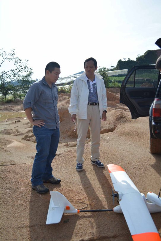
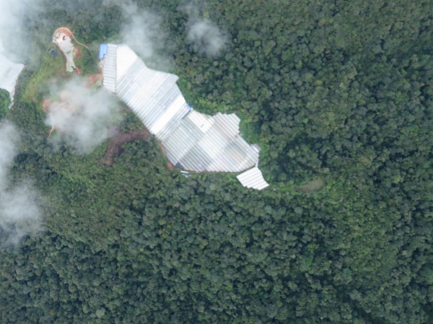
My team and I used the Parrot Disco for a few days of whale and dolphin surveys off the coast of Timor Leste where a cetacean migration event has been going on for the past few weeks. This effort is a partnership between the Unmanned Research Aircraft Facility, a University of Adelaide unit I lead and Conservation International, and supported by Parrot's Educational Program and a local supplier (MongrelGear).

This bird is super easy to launch and fly, as other Disco users have already noted. It is a perfect platform for operating off a boat that was following a pod of dolphins moving at ~8 knots.

We decided to bring it back down after ~15 min of video footage (with ~80% battery remaining). We went for a moving target final approach to land on the aft of the boat, which was maintaining a straight course at ~10 knots. We set up an improvised 'catch net' using a bedsheet for the Disco.

Unfortunately the bird was just short of the target, hit the stern and went for a swim. Luckily we were able to retrieve it, immediately disassembled the entire wing and its CHUCK controller, and flushed them with freshwater. Amazingly nothing was damaged, barring a scratched camera lens and the battery. We only lost the fuselage cover to the sea.

The following day, we treated all electronics (C.H.U.C.K.) and the two servos with CorrosionX. We left only the barometer untreated (well protected under the GPS). The teardown photographs are below. The antenna array is really interesting!

3689703710?profile=original

[Main board top]3689703766?profile=original

[Main board below]

3689703814?profile=original

[secondary board below]3689703722?profile=original

[Secondary board top]3689703792?profile=original

[GPS board below]3689703747?profile=original

[CorrosionX treatment all done!]

3689703837?profile=original

[Antenna arrays] 

Read more…

TrackerBots

3689665433?profile=original

One of the major challenges encountered bynatural resource management agencies is the lack of information on the occupancy, distribution and population trends of species of concern, many of which are cryptic, small bodied, and idiosyncratic in habitat selection over large extents of remote areas. And yet these same species are the most threatened due to the rapidly changing environmental conditions they are facing across space and time. At the same time, there is an equally urgent need to obtain information on feral and pest species that are contributing to the threat to native wildlife.

Conventional monitoring of small mammal species typically involves the use of VHF radio collaring and telemetry. The current application of VHF tracking systems is time consuming, labour intensive and expensive due to the manpower needs of covering extensive, remote and inaccessible terrains. Additionally, low animal recapture rate often necessitates repeated surveys, further compounding the data limitation problem and high research costs. Although GPS collars are available, they are typically not suitable for small wildlife species due to their size and weight, short lifespan, and limited signal penetration power.


In this project (TrackerBots.com), we seek to combine VHF telemetry, tracking technologies and inexpensive drone platforms to develop an integrated wildlife intelligence and monitoring system that is low cost, user friendly and easily deployable.

This research is a collaboration between the Auto-ID Lab and URAF at the University of Adelaide. The project is supported by the Department of Environment, Water and Natural Resources (DEWNR).

Visit our website for more information: http://TrackerBots.com

Development Team

Read more…

Conservation Drones Recycling Bin

Recycle drone

ConservationDrones.org has benefited tremendously from the generous support of many groups. We are launching a new initiative to pay this forward.

If you have 'preloved' drone equipment in working order that are just lying around gathering dust and rust, why not donate them to needy users, especially student groups, around the world who might be struggling to build their first  drone for conservation research and applications. We will try to connect donors with recipients. Please fill in this form to participate in this worthy cause!


Read more…

(Right-click here to download the first RAW video file in its native 324 resolution.)

(Right-click here to download the second RAW video file in its native 324 resolution.)

ConservationDrones tested a backpack for the FLIR Tau 2 Cores, which allows RAW digital data output from the FLIR to be recorded onto a USB stick (both video and stills). Not only is this digital video much clearer than a conventional analog output from the FLIR, but it also allows the user to read the temperature of each pixel on the video or still image using an accompanying ThermoViewer software! Additionally we can also parse flight data, such as GPS coordinate and altitude, directly onto the digital recording.

3689619569?profile=original

Markus Ax and Stephen Thamke are the two young founders and managing directors of the Germany-based start-up, TeAx Technology, who kindly provided us with a demo unit of this ThermalCapture backpack that they developed.  They are super responsive on the emails as well.

For this particular test, we were using a FLIR Tau 2 – 324 with 9 mm lens at 8.3 Hz refresh rate. The FLIR core, ThermalCapture and a dedicated battery weigh only 233 g! They were carried by a 3DR X8 multirotorIn the first video, it was flying at about 25 m above ground filming Serge Wich in the field. In the second video, the X8 started flying towards some cows in a field from about 100 m away.

Features at a glance:

  • Store Digital RAW data on your USB-Stick
  • No transmission errors in images any longer
  • Hardware update possible for every existing FLIR camera
  • Provides position and time (GPS) based on UAV downlink
  • Weighs only 45g including housing
  • Easy post-production due to free ThermalCapture software
  • Auto conversion feature to reduce time
  • Customer requests can be added at any time

3689619529?profile=original

3689619391?profile=original

3689619542?profile=original

3689619612?profile=original

3689619655?profile=original

Read more…

3689602197?profile=original

This is a compressed orthomosaic of a 1-ha plot of mallee bushland near the OzFlux tower at the Calperum station located within the Riverland Biosphere Reserve in South Australia. Environment Institute researchers, Lian Pin Koh and Wayne Meyer, spent a day in the bushland mapping this area.

The images were captured using a 3DR Y6 multirotor flying at 40m above ground level carrying a Canon Powershot SX230 running a 1-second intervalometer script (CHDK-hacked firmware). Photos were geotagged using the mission log from the drone.

It was late in the winter afternoon when this particular flight was done. So the light condition was less than ideal. But the images were still reasonably good. The ground resolution of the images was 1.21 cm per pixel.

Click here for the raw images which are freely available for download.

Read more…

Conservation Drones for Seabird Monitoring

3689591695?profile=original

A research team led by Jarrod Hodgson and Rohan Clarke from Monash University is partnering with ConservationDrones to use UAVs for seabird monitoring. Jarrod and Rohan have just returned from a successful trip to remote islands in north-western Australia. They brought along a 3DRobotics X8 multirotor UAV which they used to capture very high resolution images of nesting seabirds on these islands.

After some preliminary testing, Jarrod and Rohan discovered that they could fly at an altitude of 75 m above ground level, without causing disturbance to the birds. They also found that flying at lower altitudes would work for large nesting species. But smaller non-nesting species were easily flushed from perching sites by the UAV flying at 40 m a.g.l.

The team from Monash University made a total of 9 successful flights with the UAV. They were targeting colonies of Crested Tern and Lesser Frigatebird. The Crested Tern colonies represent a medium-sized species that nests in dense colonies on the ground (see picture), whereas Lesser Frigatebirds are a large seabird which nests in smaller groups typically on elevated nest stacks and within vegetation.

For every successful survey, the team dispatched experienced seabird counters to make 1 – 2 blind counts of the surveyed population. They will be comparing these ‘ground counts’ with UAV aerial counts to assess the reliability of UAV data.

This is a fantastic demonstration of yet another application for conservation drones. The ConservationDrones team is excited to continue our collaborate with Jarrod and Rohan in several upcoming projects. Check out their new project site: ResearchEcology.com.au!

Read more…

In our most recent drone trip to SE Asia, the ConservationDrones team brought along with us a Y6 Multicopter (http://3DRobotics.com). And it was a good thing we did because we were having some difficulty mapping a 1-hectare forest with a fixed-wing aircraft (too small an area for a fast-flying fixed-wing). The 3DR Y6 was perfect for the job as it mapped the plot in a single 1.5 km mission with no problem.

Read more…

Drone Crash!

(Repost from: http://conservationdrones.org/2013/10/12/drone-crash/)

People often ask how often we crash our drones. It really isn't that often nowadays. But when it happens, a crash is caused by human error 99% of the time. During our trip to Panama, we had two crashes because we set 'receiver failsafe' to 'Fly-By-Wire' (FBW) by mistake. As soon as the drone flew out of radio range, the autopilot switched out of 'Auto-mission' mode into 'FBW' mode. This video clip shows the last few seconds of a truly unmanned and mission-less drone as it drifted over Barro Colorado Island and into the Panama Canal. No drone was harmed in the making of this video. It was safely retrieved and had only water damage to the autopilot and some electronics.

Read more…

3689547811?profile=original

Immediate opening at the Smithsonian Tropical Research Institute (STRI) for an intern / fellow / research assistant to collect high-resolution aerial photos with unmanned aerial vehicles (UAVs).  Responsibilities will include assembly of UAVs, maintenance and repair of UAVs, weekly operation of UAVs to collect images, processing of collected images, collection of auxiliary field data (e.g., linking tagged trees with crowns visible on images), data analysis, and contribution to scientific publications.  Data collection will be focused in the Agua Salud experiment and the Barro Colorado Nature Monument (especially the 50 ha forest dynamics plot on Barro Colorado Island and long-term experimental plots on Gigante peninsula).  The successful candidate will work with staff scientist Helene Muller-Landau and collaborators, including Jonathan Dandois (http://ecosynth.org/), Lian Pin Koh (http://ConservationDrones.org), Stephanie Bohlman, Jeff Hall, S. Joseph Wright, and more.  The Smithsonian Tropical Research Institute is home to a vibrant scientific community of 30 staff scientists, over 100 graduate and postdoctoral fellows, and over 500 scientific visitors per year.

panamatropics.jpg?w=300&width=240

The ideal candidate has experience with UAVs or demonstrated possession of relevant mechanical and electronics skills, interest in and some basic knowledge of forest ecology, past experience in field research or some other outdoorsy job or pastime, experience using GPS, experience with GIS and remote sensing software, basic programming skills (e.g., Python, R, Matlab, or C++), a bachelor’s degree in a relevant field, good English communication skills, at least basic Spanish communication skills, a driver’s license, and ability to drive a vehicle with manual transmission.  The start date is flexible, but would ideally be as soon as possible, and no later than December 1.

This position will be compensated with a modest stipend sufficient to cover living expenses in Panama (minimum $800/month; negotiable).  Initial appointment is for one year (minimum commitment of 9 months is required), and is renewable contingent on satisfactory performance and availability of funds.

To apply, please email a cover letter describing your qualifications and interest in the position, CV, and contact information for 3 references to Helene Muller-Landau at mullerh@si.edu.  Review of applications will commence on September 15, 2013, and continue until the position is filled.


Read more…

Super simple script for remote camera triggering

(Re-post from: http://conservationdrones.org/trigger-camera-remotely/)

I know there are already lots written about remote triggering of cameras, including one on 3DR's webpage. I just want to share an extremely simple ‘.bas’ script that works well with a CHDK-USB cable gentWIRE-USB or E-flite LED controller). BTW, see Flightriot.com’s excellent video on how to build such a cable.


@ConservationDrones Remote Script 9/2013
:wait
if is_key “remote” then goto “loop” else goto “wait”
:loop
shoot
sleep 1000
if is_key “remote” then goto “loop” else shut_down


To start taking pictures, flick a switch on your radio transmitter (or output a PWM>1900 signal from APM). The camera will continue to take pictures repeatedly as long as the switch is in the ‘ON’ position (or PWM>1900). To stop taking pictures and shut the camera down, simply flick the transmitter switch back to the ‘OFF’ position (or output a PWM<1100 signal from APM).

Read more…

Vegetation Monitoring UAV – Greenland

Vegetation Monitoring UAV - Greenland from jtk on Vimeo.

(Re-post from Jeff Kerby @ http://vimeo.com/69579388)

To better understand arctic herbivore foraging ecology, we need information about the timing of plant growth (i.e. plant phenology) at high resolution over several square kilometers.

The solution: A vegetation monitoring UAV!

Still in the testing phases here, but we’re using a small point-and-shoot camera (Canon S100 or Sony NEX 5n) mounted on this lightweight aerial platform (GoPro used for video footage) to map changing patterns of vegetation growth throughout the season. Using the high-resolution maps made by stitching these photos together, we are able to study patterns of vegetation development at spatial scales that even the most sophisticated satellites cannot match. This approach avoids the high costs and logistical constraints of traditional airplane-based mapping.

The logistics of supporting this out on the Greenland tundra, however, are quite challenging! Should have brought a few more spare parts with me.

Footage taken by Jeff Kerby and Christian John.
UAV construction and support from Lian Pin Koh at ConservationDrones.org

Read more…

Techpod High Altitude Flight Test

ConservationDrones.org tested the vertical limit of the Techpod in open ocean and 30-40 km per hour wind conditions. We were aiming to reach 1 km above sea level. But the motor gave up at 700 m, from where the APM guided the Techpod down extremely well. During an attempted manual landing (on Stabilize mode), it crashed into a mangrove tree with damage only to the motor mount. Motor was completely burned out though.

Airframe: Techpod (2.5 m wing span)
All-Up-Weight: about 2.5 kg
Motor: Turnigy 3536 1000 kv
Propeller: 11 x 6
Battery: 2 x 5000 mAh Turnigy
Autopilot: APM 2.5+
Telemetry modems: RDF900 (ground station) & 3DR (onboard)

Read more…

Marine Conservation Drones

ConservationDrones.org went to Glover's Reef in Belize upon the invitation of the Belize Fisheries Department and Wildlife Conservation Society. We explored the use of our drones for supporting enforcement of marine conservation areas.

Glover's Reef is about 50 km offshore with winds of 30-40 km per hour. We flew a modified version of the Techpod (thanks, Wayne!) and a custom-made Wing. Both did extremely well in the winds.

The Techpod made a failed attempt to climb to 1 km above sea level. Its motor burned out at 700 m, but APM glided it down to a 20x20 m landing spot in gusty winds! (We will post that story soon.)

We collected over 40 GB of video footage, which is being edited. This is just a sneak peek.

Read more…