All Posts (11086)

Sort by

Knysna, South Africa Drone Company flying high

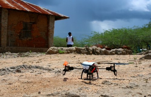
Big kudos to Duran and team from the small picturesque tourist town of Knysna

Magic place to setup a drone company

steadidroneengineer.jpg

Source :http://www.knysnaplettherald.com/news/News/General/129943/Knysnas-drones-fly-high

For most successful business owners the sky is the limit, but for Knysna’s ace drone developer and manufacturer Duran de Villiers, it has become his playground.
 
And the founder of SteadiDrone’s passion for his trade has not gone unnoticed as he recently made the 2015 Forbes 30 Under 30: Africa’s Best Young Entrepreneurs list, which recognises the continent’s top young businessmen and –women who are set to become future business leaders. This just more than two years after establishing the company.
 
“It is has been an honour and humbling experience to have won various awards over the last two years, the latest being named one of the Forbes 30 most promising young entrepreneurs in Africa this year – to be among 29 other amazing young people who are doing amazing things. I really believe it's simply a mindset: doing instead of thinking. There are many problems out there to be solved, one just needs to get stuck in, and one thing leads to the next," De Villiers said.
 
SteadiDrone designs, develops, manufactures and exports small, unmanned aerial systems, commonly known as drones. These are used for various applications including search and rescue, feature film-making, aerial photography and videography, mapping and even agriculture.
 

“Our products can fly various cameras and payloads from 200g up to 8kg. Our systems include full GPS flight controllers, autonomous flight and missions, stabilised camera gimbals and advanced multi-rotor drones.”

SteadiDrone currently manufactures three models, including a small unit, the FLARE, aimed at flying small action cameras. They also produce a medium drone, the MAVRIK, for larger and more advanced cameras and then a large drone, the X, for long endurance flights and delivering payloads of up to 8kg.
 
The locally produced products is also very competitive on the global market due to several features, including its 'rapid deploy airframe design' which is foldable and allows the drone’s owner to 'fold' the device for easy transportation. “They are also fully ready to fly with everything needed to get off the ground. We have a very unique look and design and our systems are of a very high quality.”
 
All the research, development, testing, manufacturing and marketing are done locally and products are distributed worldwide.
 
The establishment of SteadiDrone did not happen overnight and was built on the foundation of his previous business, Motion Pixel – a media productions company.
 
“With our media production company I saw the need and potential in offering our clients aerial media that simply was not possible and available with traditional equipment. There was a need for capturing aerial images at a fraction of the cost and many times faster and more effectively than the full-scale aircraft alternative. After building our very first drone, I just fell in love with the technology and again saw the potential for manufacturing instead of simply offering the service. We quickly transformed our media production company into an international drone manufacturer and two years on we are one of the leading companies in the industry.”
 
De Villiers, who grew up in Knysna and matriculated from Knysna High School, did not think twice about establishing SteadiDrone’s headquarters in his hometown.
 
“People seem to think Knysna is a tourism town when in fact it was and should be a manufacturing town, a hub of excellent local pioneers selling abroad and bringing money into town, creating employment for locals and actually making a difference. It's easy to make an impact via media and the news, but we need more deep-rooted, growing businesses in town, not necessarily more tourists.”
 
Over the last two years, the business also expanded rapidly due to the booming international drone industry. “We were fortunate to get involved when we did. We've gone from three staff members to 12, from working in a small studio to a large 800m² workshop. Not much has changed in terms of how we run the business, simply improving our products and marketing.”
 
And he attributes his success to, among other factors, the realisation that hard work pays off. “I think everyone wishes and hopes to do well but very few actually ever do, and again, I think it's a mindset. I've realised early on that if I don't push hard, work hard, put in the late nights, effort and time - something no one ever sees - it won’t happen. If I don’t make it happen it simply won’t. I don’t want to be just another number, I'd like to make some form of impact and I think that is the kind of thinking that has brought us here – along with God's grace and blessings.”
 
He added another key ingredient in his recipe for success was good support. “The first ingredient is the best wife anyone could ever ask for, Alexa. April marks our 10th wedding anniversary and everything I do is because of her and her support. She is very much a part of this, often more than I am, and I think it's the key to our success thus far, nothing beats a good team and passion. Great staff are vital - having a core team that you can trust and depend on - and then pure and simple hard work.”
 

De Villiers is no stranger to awards and in he 2009 won a Sony Professional Photographers of South Africa gold award and in 2013 received a Step-Up Technology Innovation Award. Last year he also made the Mail & Guardian Top 200 Young South Africans list and won a Sanlam Outstanding Achievement Award.

“It is really awesome to receive this recognition as it really pushes us to do more and go further.”
 
ARTICLE: YOLANDE STANDER
 
'We bring you the latest Knysna, Garden Route news'
Read more…

DIY Angle of Attack Wind Vanes - Part 2

Numerical Simulation of Von Karman Street generated by a strut

This post is the second part of a series; the first part can be found here. It is an introduction to the math related to this DIY wind vane. Background information will be presented, essential to the design process. This post is focused on the design of an Angle-of-Attack vane. A sideslip angle design follows the same principles. 

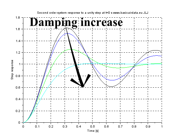
Modeling the dynamics of the wind vane a second-order system as model, we end up with two significant parameters of the system: resonance frequency and damping. Initially, bearing and other sources of friction on the main shaft will be neglected. A known resonance frequency value is used to verify that the wind vane is not excited by other mechanical devices, as depicted in the previous part. Wind gusts are generally an intended source of AoA readings, but we must ensure that their frequency content does not approach nor exceed the resonance frequency, so as the frequency response of our system has unity magnitude. Damping indicates how faster an excited oscillation decreases with time. The following picture illustrates the time response of a second-order system, while varying the value of damping. Our wind vane will be underdamped, hence its damping value will lie withing the (0,1) range.

The following equation defines a second-order transfer function using common notation. Since our vane will be underdamped, the typical time response will be oscillatory, with an exponential time decay term which reduces the oscillation magnitude in time.

3689636170?profile=original

3689636223?profile=originalis the natural frequency

3689636131?profile=originalor zeta is the damping

Equation AOA 1 - Standard second-order transfer function. Transfer function DC gain is equal to one.

3689636228?profile=originalis the damped frequency, oscillation in time occur at this frequency

Equation AOA 2 - Damped frequency definition

7_1a.png?width=400

Figure AoA 5a - Second order system step response

Damping values as follows Black 0,15, Blue 0,2, Green 0,4, Light blue 0,8.

7_1b.png?width=400

Figure AoA 5b - Second order system step response

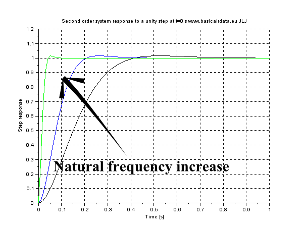
Natural frequency value as follow Black 10, Blue 20,Green 100.

Inspection of the previous figures reveals that for good system behaviour (fast and stable measurements) we need a high value for both resonance frequency and damping. A SciLab file available for experimenting with parameter values can be found here. To increase wind vane resonance frequency, much like many mechanical systems, inertia decrease is required. Our wind vane is statically balanced with a fore mass and the overall weight can be decreased by enlarging the distance of the counterweight and decreasing the distance of the fin from the rotation axis of the vane. On the other hand, using a long fin arm will increase the damping of the system which is an also desirable characteristic, as is also described here, eq.6.

Thus, we end up with two conflicting requirements in our design phase. If an extremely fast dynamic response is needed, the ideal design is a leading edge wind vane, which is a vane that pivots directly in the leading edge of the fin, with no counterweight. If high values of damping are required, the classical long-armed wind vane is more promising. Since there is no dominant argument when choosing those values, a value greater than 0,15 is a good start, in order to avoid uncontrolled oscillations during operation. A damped system oscillates at the damped frequency 

Wd of eq.2, as per figure AoA 5b.

When damping is low, the damped frequency value is close to the natural frequency. Natural frequency should be two times the maximum frequency of the measured quantity, in order to ensure unity measurement gain. Also, as has been said in the previous post, vane resonance frequency should be lower than 0.7 times the Airboom resonance value, or at least, this is a good first estimate; the more distance between the two resonance frequencies the better.

In a typical operating scenario, the vane will have to deal with a constant wind, with gusts superimposed on it. For design and simulation purposes gust models are available, such as the Dryden, FAR and FAR2 models. Wind gust library blocks also exist in many simulation packages.

[Read More]

Read more…

CBC Documentary: The Age of the Drone

ageofthedrone_1280.jpg

On February 19th at 9PM, the Canadian Broadcast Corporation will air a new documentary on drones, following up the one they did last year called Remote Controlled War.  Last year's was more focused on the military aspects, this new one is more commercial/recreational.

I'm not sure what the availability will be for those outside Canada.  Hopefully our public broadcaster makes it widely available.

Read more…
3D Robotics

No drones at this year's Sparkfun AVC :-(

3689638090?profile=original

Sparkfun has just announced the rules of this year's Autonomous Vehicle Competition, and the big news is that drones are no longer part of it for safety reasons. Having witnessed the crash they say precipitated this (which was as scary as they say), I have to agree that the logistics of this competition and limited crowd control makes this a good call IMO. 

First off, the most important change. There is no aerial category for this year’s competition. We know, this is a disappointment to many people, but hear us out. Last year, we had a few too-close-for-comfort calls involving aerial bots and the crowd. We literally have nightmares about someone getting hurt by a quadcopter. One incident in particular (that left a large dent in a chainlink fence), gave us serious hesitation about the safety we could provide our guests.

Furthermore, with the booming popularity of quads and other drones, there are more and more regulations in place. This year’s location (our new building - more on that below!) is quite close to Highway 119 and we are not legally allowed to have aerial vehicles – particularly unmanned ones – zipping around. Also, frankly, there just isn’t the space for it – we want AVC to be the best it can be, and that wouldn’t be possible in the space we have available.

With that out of the way, we do have a number of exciting changes that will hopefully pique your interest!

alt text

This year’s course.

The ground category rules will largely be the same as in the past. You can see the full rundown of rules over on our AVC site. Of note is that we are adding an incentive to folks that do not use GPS in their bots. There will also be a special shortcut to be revealed at a later date.

alt text

Hanging out on our rooftop. It was Halloween - Nate doesn’t always dress like that.

Also, as I said above, this year’s AVC will be at our new building! We are pretty proud of our new digs and are excited to show it off. If you haven’t seen the new place, this will be your chance!

alt text

Casey, SparkFun Engineer and Master of Destruction, is spearheading the combat robot competition. Be afraid.

And finally – and maybe the addition we are most excited about – is that there will be a 1 lb Combat Robot competition! If you haven’t ever seen combat robots in action, it is pretty darn exciting. We are expecting a great turnout and hope to see some awesome destruction.

In addition to the robotics portions of the event, we are planning another hackathon (details to be announced at a later date), as well as project demos, booths from folks in the maker community, food trucks and more!

Read more…

Iris/Pixhawk Cold Weather Testing

Last weekend I drove up north a bit for some real cold weather testing of my Iris+ equiped with Pixhawk.  I had to get up early in the morning to catch -30C temperatures which is about as cold as I'm interested in testing.  At -30C, my gloved fingers froze after a few minutes.  Not quite frostbite, but deep into pain territory.

Spurred on by Leonard's taunts, I also did some snow resistance testing.  It passed.  I'd say it can handle just about any amount of snow you could reasonably throw at it. :)   I simply put electrical tape over the shell vents, and that's it. Throughout the weekend, I had absolutely zero problems related to the low temperatures. -30C is a non-issue for the Pixhawk and ESCs. 

I actually haven't had this Iris for long, but so far I'm pretty impressed with it.  The out-of-the-box tune was pretty much spot on.  It flies extremely smoothly.  The only changes I've made were to allow 45° lean angle, and enabling Stab and Acro modes.  The camera I was using for on-board is a Sony AS100V on the semi-fixed front mount included with the Iris.  The results are not great, heavy jello.  I'm not sure if a real GoPro is much better?  You can see the effect of the Sony's electronic image stabilization.  If you peer through the jello, you can see that the video is actually quite smooth and watchable.  I will probably make a damped undermount for the camera.

Read more…

HOW ACCURATE ARE YOUR MAPS AND MODELS?

3689638061?profile=original

Making maps with the help of small UAVs seems to be easy enough. However, when geometric accuracy is critical, how do you determine and state the estimated accuracy of your mapping product? One way is to establish a test bed with a redundancy of accurately surveyed check points which are used as independent bench marks against which the map can be compared. In this picture we show a comparison between high accuracy GPS derived check point coordinates and corresponding coordinates as derived from our 3D model. Note that for illustration purposes the horizontal errors were scaled by a factor of 1000.

The 3D model was created from 261 aerial images (13mm GSD) captured by a Sony a6000 camera with 16mm fixed lens. The camera was carried by a Pixhawk equipped modified Steadidrone quadcopter. The flying time was 10 minutes and, using our V-Map system (http://www.microaerialprojects.com/v-map/ ), we could accurately survey the 12 ground control points in about 15 minutes.

Using 105 check points in our error analysis we can now confidently claim that when we map similar terrain with this particular method we can realistically expect to achieve the following accuracy:

Horizontal approximate circular error at 95% confidence 0.028m
Vertical Accuracy at 95% confidence: 0.039m

Not bad, especially when considering that the 4.75ha map can be delivered the very next day after image acquisition.


Read more…

Ghetto controller idea

I've been having fun with bluetooth telemetry bridge units for a while now. Recently I decided to have a go at combining/integrating such a unit with a remote to get some more ease-of-use and functionality out of it. So I here is my result:

3689637976?profile=originalIt means fewer wire to connect, no relying on separate battery connections and charging, it's removable from the unit and can be mounted to something up high to increase range (like a football post for example)  I'm really happy with it and i'm even happier to build one for you if you wish to have one, just drop me a line.

Happy to answer some questions

Thanks.

Read more…

IR-LOCK Sensor for Precision Landing, etc

3689637928?profile=original

We finally have a progress report on the integration of the IR-LOCK (Infrared Pixy) vision sensor with Pixhawk. A group of students at the Georgia Institute of Technology is using the sensor for their 'Package Delivery Drone', which requires precision landings. They plan to use GPS to travel to a waypoint, and then use the IR-LOCK sensor to land precisely on an infrared beacon. Recently, they were able to get an IRIS+IR-LOCK to auto-hover over an IR beacon (see videos). 

Other applications for IR-LOCK/Pixhawk are in the works (or at least in mind):

  • Search&Rescue (auto-search for emergency IR beacons)
  • Moving target following
  • Aerial surveying (I will be able to post a relevant video soon)
  • ... your thoughts/ideas are welcome :)

We are in the process of making the IR-LOCK/Pixhawk interface more developer-friendly. The current developments (by the student group) are based on an IR-LOCK sensor 'driver' and codebase discussed on this FAQ page (link). A 'more official' implementation should be under development soon. The relevant discussion is here (link). 

Small IR 'Pods' can be detected by the IR-LOCK sensor at about ~30-60ft. The IR-LOCK sensor reports the (xy) position of IR targets to Pixhawk at 50Hz. 

3689637963?profile=original

Read more…
Moderator

The official presentation of VR Spark 350 will take place at DroneShow Ferrara 28/29 March 2015.

The latest revisions of VR Spark 350, currently undergoing certification, will be presented on a confidential basis to some selected beta testers at the 2015 FIAPR convention.

VR Spark 350 was born after a year full of experiments, where we worked on improving electronic technologies, mechanical design, usability for end user and the possibility to be used for commercial purposes respecting regulation rules that govern the use of drones in the civil aviation world.

3689637728?profile=original

We implemented control systems and flight termination to ensure compliance with the Italian and French rules and to achieve high levels of safety and reliability. It has a maximum take off weigh under 1.6 Kg. (3.4 pounds) to take advantage of the imminent FAA and European regulations that will enable smaller drones to fly in restricted areas.

We are currently undergoing experimentation to achieve Italian and French approval for commercial use, and plan to start selling in April.

VR Spark 350 main applications are:

  • low budget filmography.
  • safety and rescue.
  • Video inspection .
  • Marketing (drones branded for promotion - delivery -)
  • Automatic features as  follow me through VR platform Leash. (Action Sports)
  • Photogrammetry.
  • Training schools for professional pilots.
  • Suitable for drones startups company and research projects (eg H2020).

This multi role machine aims to enter as a protagonist in the business services using drones.
It has all the features to aspire to be the Italian answer to the Chinese DJI Phantom. The semplicity and portability of a DJI Phantom, but with so many more payload options and flexibility!

Technical Specification:

  • Frame configuration : Multicopter Quad .

  • Propeller:  9x4.5

  • Motors:  980 KV

  • Time of flight 18 min.

  • Weight : 1.6 kg al decollo.

  • Flight Control : VR Brain 5.2 PRO ( VR SPARK CUSTOMIZATION)

  • GPS : VR GPS 8 GNSS dual mode navigation system GPS / GLONASS.

  • Flight Termination System : VR Flight Stop PRO Power Cutoff + Parachute. (option)


  • Radio Link:

    • Primario: SBUS FRSKY X4R

    • Secondario: Terminatore di volo : PPMSUM FRSKY D4R


  • Telemetry:

    • FRSKY S.PORT.

    • VR Link 868 / 915 (Mavlink telemetry module)

    • VR OSD ( Video overlay main telemetry information : attitude , GPS , Battery)


  • Standard Payload 2 Axis Brushless Gimbal + GoPro 4 Hero Black.

  • PAYLOAD Option Max Weight ( 500 gr)

  • Battery 3S 4000 Mah.


3689637879?profile=original

It is thanks to the work of a large community made up of people with great competence, passion and technological skill that this project has seen the light.

Thanks to Virtualrobotix and the APM:Copter DEV team which has done an excellent job bringing this platform to high levels that was, in its infancy, within the reach of only a few experts.

Now after extensive work on the simplification and usability, so many more professionals can enjoy the flexibility and power of this platform.

for info contact : info@virtualrobotix.com 

original blog post : http://www.virtualrobotix.com/profiles/blogs/we-decide-the-date-of-the-official-presentation-of-the-vr-spark-3

Read more…

3689637830?profile=original

Luke Runyon of Harvest Public Media came to Agribotix last week to do a story on the use of drones in agriculture and the FAA issues involved.  We took him out to our favorite local farm and had a grand time flying quads.  Fortunately the story was picked up by National Public Radio so it had a US-wide distribution (link to the story).  In addition to Agribotix, Luke interviewed Eric Frew of the University of Colorado Research and Engineering Center for Unmanned Vehicles and Rory Paul of Volt Aerial Robotics.   All-in-all I think it brought some good PR to the commercial drone space at a time when we've been getting a few black eyes from irresponsible hobbyist.

Read more…

TanaPic1

The Sentinel Project recently launched their Human Security UAV program in Kenya’s violence-prone Tana Delta to directly support Una Hakika ("Are You Sure"). Hakika is an information service that serves to “counteract malicious misinformation [disinformation] which has been the trigger for recent outbreaks of violence in the region.” While the Tana Delta is one of Kenya's least developed areas, both “mobile phone and internet usage is still surprisingly high.” At the same time, misinformation has “played a significant role in causing fear, distrust and hatred between communities” because the Tana Delta is perhaps parado-xically also an “information-starved environment in which most people still rely on word-of-mouth to get news about the world around them.”

In other words, there are no objective, authoritative sources of information per se, so Una Hakika (“Are You Sure”) seeks to be the first accurate, neutral and reliable source of information. Una Hakika is powered by a dedicated toll-free SMS short code and an engaged, trusted network of volunteer ambassadors. When the team receives a rumor verification request via SMS, they proceed to verify the rumor and report the findings back (via SMS) to the community. This process involves “gathering a lot of information from various different sources and trying to make sense of it [...]. That’s where WikiRumours comes in as our purpose-built software for managing the Una Hakika workflow.”

TanaDeltaPic2

A year after implementing the project, the Sentinel team carried out a series of focus groups to assess impact The findings are particularly encouraging. In a way, the Sentinel team has formalized and stream-lined the organic verification process I describe here: How To Use Technology To Counter Rumors During Crises: Anecdotes from Kyrgyzstan. So where do UAVs come in?

The Sentinel team recently introduced the use of UAVs to support Una Hakika’s verification efforts and will be expanding the program to include a small fleet of multi-rotor and fixed wing platforms. Before piloting this new technology, the team carried out research to better understand local perceptions around UAVs (also referred to as Unmanned Aerial Systems, UAS):

“Common public opinion concerns in places like Europe and North America relate to the invasion of privacy, misuse by government or law enforcement, a related concern about an overbearing security state, and fears of an aviation disaster. Concerns found among residents of the Tana Delta revolve around practical issues such as whether the UAS-mounted camera would be powerful enough to be useful, how far such systems can operate, whether they are hampered by weather, how quickly a drone can be deployed in an emergency, and who will be in physical possession of the system.”

“For the most part, they [local residents] are genuinely curious, have a plethora of questions about the implementation of UAS in their communities, and are enthusiastic about the many possibilities. This genuine technological optimism makes the Tana Delta a likely site for one of the first programs of its kind. The Sentinel Project is conducting its UAS operations with the policy of ‘progress through caution,’ which seeks to engage communities within the proposed deployment while offering complete transparency and involvement but always emphasizing exposure to (and demonstration of) systems in the field with the people who have the potential to benefit from these initiatives. This approach has been extremely well received & has already resulted in improvements to implementation.”

While Una Hakika’s verification network includes hundreds of volunteer ambassadors, they can’t be everywhere at the same time. As the Sentinel team mentioned during one of our recent conversations, there are some places that simply can’t be reached by foot reliably. In addition, the UAVs can operate both day and night; wandering around at night can be dangerous for Una Hakika’s verification ambassadors. The Sentinel team thus plans to add InfraRed, thermal imaging capabilities to the UAVs. The core of the program will be to use UAVs to set up perimeter security areas around threatened communities. In addition, the program can address other vectors which have led to recent violence: using the UAVs to help find lost (potentially stolen) cattle, track crop health, and monitor contested land use. The team mentioned that the UAVs could also be used to support search and rescue efforts during periods of drought and floods.

Tana3

Lastly, they’ve started discussing the use of UAVs for payload transportation. For example, UAVs could deliver medical supplies to remote villages that have been attacked. After all, the World Health Organization (WHO) is already using UAVs for this purpose. With each of these applications, the Sentinel team clearly emphasizes that the primary users and operators of the UAVs must be the local staff in the region. “We believe that successful technology driven programs must not only act as tools to serve these communities but also allow community members to have direct involvement in their use”.

As the Sentinel team rightly notes, their approach helps to “counteract the paralysis which arises from the unknowns of a new endeavour when studied in a purely academic setting. The Sentinel Project team believes that a cautious but active strategy of real-world deployments will best demonstrate the value of such programs to governments and global citizens.” This very much resonates with me, which is why I am pleased to serve on the organization’s Advisory Board.

This blog post was cross-posted from iRevolutions. More on the humanitarian uses of UAVs/drones in my new book Digital Humanitarians.

Read more…

3689637720?profile=original

This post highlights the business impact and market opportunities the proposed rules brings to drone manufacturers, distributors, service providers, and investors. It also appears in sUAS News 'The Market'.

---

On February 15, 2015, the commercial drone industry breathed a collective sigh of relief. The Federal Aviation Administration’s proposed new rules for small unmanned aircraft systems seemed, at first blush, somewhat practical.  The FAA regulations will eventually allow commercial operations of drones that weigh under 55 pounds in U.S. airspace, without requiring operators to acquire a pilot’s license. You can read the full 195 pages of proposed rules here(hereafter sUAS notice of proposed rulemaking, or NPRM) and some analysis about them here, here, and here.

In this post, I’ll focus on what I think are the immediate economic winners and losers.  My analysis is concentrated on the business impact and market opportunities that the proposed rules have for drones manufacturers, distributors, service providers, and investors.

What do investors need to know?

According to CB Insights data, 2014 investments in the budding drone industry topped $108M across 29 deals. Year-over-year funding increased 104% as venture firms jumped into the drone space with sizable bets. Still, over the past couple of years, I’ve heard VCs and potential investors discussing the FAA bottleneck and questioning whether this was the right time to invest.  Regulatory uncertainty has kept many on the sidelines. But this new clarity should help investors, including those interested in investing in operational and data / information services.

Read more here: http://droneanalyst.com/2015/02/16/faa-drone-rules-market-winners-and-losers/

Read more…

Baseflight, cleanflight, CC3D, oneshot125, BLHELI Simonk, Looptime, PID controllers

What does all this mean?

I haven't seen anyone post about this on here so I thought it would be a good chance for people to have a look at the amazing performance people like CHARPU are getting from miniquads.

Take a look at the onshot125 esc firmware video below and some of the other vids!

The technology for miniquads has come so far in just a few months and is changing daily. New motors for miniquads are coming out what seems like every week. Similar to the endurance copters people were experimenting with last year... It's also something that DJI and 3DR haven't touched so far...

here's one of my vids (i'm still learning)

If you're interested in getting into miniquads you should check out the miniquadclub

Read more…

3689637759?profile=original

This is a new Android App for running a Heads Up Display on a SmartPhone or table computer or Windows. It's available on the Google Play store at https://play.google.com/store/apps/details?id=org.qtproject.qtgstreamer

If you want to side-load, I have posted a free version on dropbox at https://www.dropbox.com/s/g38tv79z3ey8yks/QtGStreamerHUD.apk?dl=0

There is also a windows version available at https://www.dropbox.com/s/km52szl7ghdo15a/GStreamerHUDApp.msi?dl=0

This app will overlay the HUD on a video stream using GStreamer, or you can run the app without video with a normal HUD.  

The App will automatically listen for a MAV-Link data stream on UDP port 14550, the default UDP port for MAV-Link. You can also configure the app to use TCP, and on windows you can connect directly to a serial port. 

If you want to display data on a ground station PC and the App at the same time, you can use MavProxy to split the UDP stream, and then connect to your UAV using Mission Planner. 

Here is a sample command that I use to split the data stream with MavProxy:

mavproxy --master=COM5,115200 --out=192.168.0.1:14550 --out=192.168.0.126:14550

The ground station PC is at 192.168.0.1, and the SmartPhone is at 192.168.0.126 (on my wifi network).  You will have to configure the IP address according to your own WiFi network. My WiFi network in the field is a Ubiquity Rocket M5 configured as an access point, and a second M5 is on the UAV, so I can get live video from the UAV over the same network that connects the smartphone. 

For the windows version, you can run the HUD on the same PC as MissionPlanner (or APM Planner), and use MavProxy with a different UDP port for the HUD.  

If you want to use the video overlay, you will need to have a valid gstreamer data stream running, either over UDP or TCP.  For my setup, I am using a Raspberry PI streaming H264 over UDP using this command on the PI:

raspivid  -t 0 -w 1280 -h 720 -fps 40 -b 4000000 -o - | gst-launch-1.0 -v fdsrc ! h264parse config-interval=1 ! rtph264pay ! udpsink host= $1 port=9000

The "$1" argument is the IP address of your GCS or SmartPhone/Tablet PC.   This command is for 720p, but you should consider the resolution of the device and adjust accordingly.  It makes no sense to send a 720p video to a phone with a 800x600 display.

In the HUD, configure the gstreamer pipeline with this string:

udpsrc port=9000  buffer-size=60000 ! application/x-rtp,encoding-name=H264,payload=96 ! rtph264depay ! h264parse ! queue ! avdec_h264

Do not include a video sink element, as the App will add this dynamically.  You can change the port to whatever you wish as long as your PCs do not have a firewall blocking the port.

Another thing to consider is the processing power of your device. If you see a lot of pixelation, your device is too slow, so you will need to change the resolution of the transmission and/or the bitrate. Some smartphones are just too slow to display the video at full resolution. I have tested 720p on my Google Nexus 6 and it works fine, but on a cheap tablet PC, I had to slow it down and switch to 800x600.  

The App is easy to setup, however if you have any questions or issues, please send me feedback.

Happy Flying!

Read more…

Smart looking VTOL construction

drone_main.jpg?w=1600

Is it a quadcopter? A plane?  No, it’s both! [Daniel Lubrich] is at it again with a vertical take off and landing transformer he calls the SkyProwler. We’ve covered some of his work before where his team designed a UAV called ATMOS for a DARPA competition.

The SkyProwler uses a switch blade type mechanism to move from quadcopter mode to plane mode. The wings can be detached to make it a normal quad that has all the typical bells and whistles. It can follow you around with GPS, fly autonomously via way points, and has this cool gimbal mechanism that keeps the GoPro stable as the drone pitches in flight, allowing for a better video experience.

[Dan’s] ultimate goal is a full size passenger model called the SkyCruiser, which uses the same switchblade transformation mechanism as his much smaller SkyProwler. Be sure to check out the video below if you haven’t already, and let us know of any quadcopter / plane hybrids of your own.

source:

http://hackaday.com/2015/02/15/quadcopter-plane-transformer-is-awesome/ ;

Read more…

A Move in the Right Direction?

3689637467?profile=original

There is much chatter as of late to possible leaks of FAA information in reference to the move towards establishing formal rules for drone use.  This morning I came across "Government proposes rules for routine use of drones" reported by Fox News. 

3689637603?profile=original


Video Reporting here.


Read more…

3689637584?profile=original

LightWare Optoelectronics (Pty) Ltd is pleased to announce that the SF30/C high speed laser sensor is now available for pre-order. This lightweight (35g) LRF uses time-of-flight technology to detect obstacles as far away as 120m at the astonishing speed of 4000 readings per second.

The SF30/C offers both a serial port and an analog output allowing the end user to choose between a high speed communication protocol or a much simpler analog comparator circuit to recognize the presence of obstacles within a predetermined distance. As with all LightWare products there is also a USB configuration port for entering settings and testing the unit.

Designed for fixed wing and 'copter platforms, the SF30/C can be used in a single or multiple unit configuration, or added to a gimbal, servo or stepper platform to form a scanning LIDAR. It has been optimized for fast measurement so with a resolution of 0.25m it nicely compliments the SF10 precision altimeters already available from LightWare.

The SF30/C is currently undergoing final testing and certification and will be available to the public from May 2015 at a price of US$850.00 (excl. shipping and duties).

Thank you to everyone at DIYDRONES who contributed to the design of this product through your critical feedback and practical suggestions. Please contact Tracy at info@lightware.co.za if you are interested in this product.

Read more…
Moderator

FAA-Puma1-1024x558.jpg?width=400


I'm still a little bewildered that folks are calling yesterdays FAA document a leak as we were sent it. Perhaps it was sent at the wrong time. They stuffed up with AIC 91/57 late last year which was withdrawn by accident. Maybe today sees the real removal of AIC 91/57 but on a Sunday. The Phantom on the lawn incident has done more to shove regs through than all the money thrown at it and talking heads since 2006.

Lets hope it does contain the sort of regs posted in the "leaked" document. If it does, the industry has lift off.

At sUAS News we believe this announce is after this November meeting http://www.suasnews.com/2014/11/32464/sfar-107-whispers-from-d-c/ but is happening quicker than expected because of that Phantom.

WHEN: 10 a.m., Sunday, February 15, 2015

WHO: Conference Call with U.S. Transportation Secretary Anthony Foxx and FAA Administrator Michael Huerta

The call-in number for the call is (800) 230-1059. The operator will ask you what you're calling in for. Tell the operator you are calling in for the DOT Press Briefing. There will be an opportunity to ask questions at the end. To ask a question press 1

https://www.faa.gov/news/media_advisories/news_story.cfm?newsId=18294

Read more…

Vision based positioning system for Drones

image.php?id=nvidia_jetson_tk1&image=nvidia_tk1_jetson2_med

Every drone is uses a GPS ranging from position hold to way point navigation. But the performance of current GPS system has massive scope of improvement. Imagine a drone which can hold its position so well that its performance is comparable to a motion capture system's position hold and likewise for the way point navigation. 

I have implemented a monocular visual odometry on Nvidia's JetsonTK1. Using this implementation, GPS can be replaced with this camera based system. I dint have the resource to implement this on an actual quadrotor but I am quite confident that visual odometry can outperform GPS system.

Here is the blog entry for the implementation. 

http://www.robnsngh.com/2014/11/monocular-visual-odometry-using-nvidia-jetson-tk1-for-uavs/

Check out the actual implementation video from the creators. 

Read more…