All Posts (11086)

Sort by
3D Robotics

CNBC's Jerry Cobb interviews Joe Bock about the models he designed and built for the movie The Aviator. The Hughes H1 Racer, The Hughes XF11, and legendary Spruce Goose airplanes originally built by Howard Hughes. Aero Telemetry designed, built, and flew these amazing airplanes for the Academy Award winning movie The Aviator.

Read more…
3D Robotics

More analysis of forthcoming FAA rules

3689637430?profile=original

This one is from Greg McNeal, another regulatory law expert

Inadvertently Posted FAA Document Provides Insights Into Forthcoming Drone Regulations

The FAA may be poised to release regulations that will impose a minimal burden on businesses, paving the way for integration of drones into the national airspace.  Information about the forthcoming regulations is contained in an inadvertently published document that appears to be an FAA economic analysis of the long awaited regulations for small drones.  In no uncertain terms, the purported FAA economic analysis assumes that drones provide great social and economic benefits, will save lives, and can be integrated into the national airspace with minimal risk while providing benefits that far outweigh their costs.

Less burdensome regulations and a recognition of the benefits of drones is a reversal from what many observers (including me) believed the FAA would do.  The economic analysis suggests that the forthcoming regulations may allow for many beneficial drone uses.  The document was obtained by a man claiming to be Steven Zeets, a professional land surveyor who filed a petition for exemption from FAA rules last year.  The user of that account stated on Twitter that the document was posted to Regulations.gov, then quickly removed, but not before he saved a copy.   (Note, after the Steve Zeets Twitter account claimed to authenticate the document I modified some of the language in this post).

The economic analysis provides insights into what the FAA considered and rejected while crafting regulations for small drones (those weighing less than 55 pounds, also known as sUAS).  The economic analysis suggests that the FAA will adopt a regulatory approach far more favorable to the operation of drones than many expected.  According to the report the FAA has decided to adopt a “minimally burdensome rule” for drones.  In fact the term “minimal regulatory burden” or a variant thereof is a key theme throughout the document.   If the economic analysis ends up reflecting a true assessment of the proposed rule, many drone advocates will be very happy with the FAA and their decision to regulate the lowest-risk small UAS operations by imposing a minimal regulatory burden on those operations.


The FAA may be poised to release regulations that will please many drone advocates — at least that’s what a document that appears to be an FAA economic analysis of the long awaited regulations for small drones suggests.

A small note of caution: As stated earlier, the document appears to be the economic analysis of the proposed sUAS rule.  The document is dated February 2015 and is captioned “Notice of Proposed Rulemaking Regulatory Evaluation, Small Unmanned Aircraft Systems” authored by George Thurston of the Office of Aviation Policy and Plans, Economic Analysis Division.  It’s possible this is a leaked draft that has since been revised or is otherwise incomplete or inaccurate.  With that caveat lector disclaimer out of the way:

Here are 9 key takeaways regarding how the proposed FAA regulations will handle drones:

The FAA believes drones provide great social and economic benefits.  The agency admits that drones provide significant societal benefits, and that the social benefits will continue to increase as entrepreneurs enter the drone marketplace.  The agency noted that if the use of a small drone replaces a dangerous, non-drone operation and saves even one human life, that savings alone would result in benefits outweighing the expected costs of the integration of drones into the national airspace.  Specifically, the agency found that integrating small drones into the national airspace will have an economic impact of greater than $100 million per year in benefits.  The FAA sees great upside potential in aerial photography, precision agriculture, search and rescue/law enforcement and bridge inspection (specifically noting the nearly 45,000 bridge inspections that could be conducted by drones each year).    The agency estimated that at a mere $5 per acre of cost reduction, drones in precision agriculture could produce billions of dollars per year in cost savings.  For operators that can’t afford to purchase their own drone or train their personnel to operate them, there will be a market for end users to seek contracted small UAS services (full disclosure, as of aFebruary 12th, I began collaborating with Measure, a company that provides drone services on a contract basis).

Drones will save lives.  The FAA assumes drones will provide safety benefits by allowing the substitution of drones for operations that pose a higher level of public risk.  Climbers working on towers have a fatality rate that is 10 times that of construction workers, and drones can help to reduce those fatalities.  For example, 95 climbers working on cell and other towers died between 2004 and 2012.  If drones had been available for those inspections, those fatalities could have been avoided.  The FAA believes that drones will become a safer and less costly substitute for manned aerial photography, will enable safer operations than manned aircraft for agricultural purposes, and will allow quicker responses in search and rescue and disaster relief operations.  The FAA reviewed accident data related to aerial aviation photography and found that out of 17 accidents, a drone could have substituted for the manned operation in two cases — both cases could have ended in fatalities, and could have been performed by a drone.

The FAA will not require a commercial pilot certificate for drone operations.    The FAA considered requiring drone pilots to obtain a commercial pilot certificate, have a Class II medical certificate,  pass an aeronautical knowledge test, and demonstrate flight proficiency and aeronautical experience before a certified flight instructor.  The FAA determined that drones pose a low level of pubic risk and that imposing all of those requirements would be unduly burdensome.  Instead, the FAA will require an operator to pass an aeronautical knowledge test before obtaining an unmanned aircraft operator certificate, and that knowledge test will need to be taken at a certified testing site in person.  On-line testing was rejected due to concerns about the integrity of the test, and the possibility that personally identifiable information might be at risk through on-line test taking.  The FAA believes that the cost of obtaining a small UAS operator certificate will be less than $300 and the operator will be required to pass a recurrent test every 24 months and undergo vetting by the TSA.  The FAA will not require flight school and believes that little preparation would be necessary for applicants with an existing pilot certification.

The FAA decided to accommodate all types of drone businesses by adopting the least complex set of regulations across all sizes and categories of drones.   In pursuit of that goal, the FAA determined that segmenting drones into different categories based on weight, operational characteristics, and operating environment was too complex and burdensome for the public and the FAA.  By treating all small drones as a single category without airworthiness certification,the FAA believes they can accommodate a large majority of small drone businesses and other non-recreational users .  The FAA concluded that their single category rule will mitigate risk while imposing the least amount of burden to businesses and other non-recreational users of even the smallest drones.  While the FAA considered a “micro UAS” subcategory of drones — the micro drone rule proposed by the UAS America Fund —  they ultimately decided that the micro drone proposal should be treated as a comment to the FAA’s rulemaking, rather than as the separate petition that it was filed as.

The FAA considered, but rejected onerous inspection, maintenance and permitting requirements for drones.   The agency determined that such requirements were not proportionate to the risk posed by small drones.  The FAA specifically noted that the light weight of drones versus manned aircraft means that drones pose significantly lower risk to people and property on the ground.  As such, the FAA believes that inspection and maintenance of small drones pursuant to existing FAA regulations would not result in significant safety benefits.  While inspection, maintenance, and permitting requirements will not be required, the FAA notes that statutory constraints will require unmanned aircraft to be registered.  Registration fees will cost $5, and will need to be renewed every three years.

The FAA will require drones to be operated within line of sight of the operator, rejecting technology as a substitute for an operator’s sense and avoid responsibilities.   The FAA considered whether technological means could serve as a substitute for the operator’s see-and-avoid responsibilities, for example by utilizing onboard cameras.  The agency believed that technology has not yet advanced to the point where it could be miniaturized and used on board a small drone.  Specifically, the FAA found that no acceptable technological substitute for direct human vision in small UAS operations exists at this time.  Perhaps they missed theIntel announcement at CES — no doubt this will come up in the comments to the NPRM.

Drone flights will need to take place between sunrise and sunset.  Regulators considered allowing drone flights after sunset, as it would allow for a greater number of drone operations in the national airspace.  However, because such flights would take place at low altitudes it would increase risks to persons on the ground.  Mitigating those risks would require equipment and certification that would run contrary to the FAA’s goal of a minimally burdensome rule.

Drone flights will need to be below 500 feet.   Fearing the risk to manned aircraft operations above 500 feet, and recognizing that flights at that altitude would require greater levels of operator training, aircraft equipment, and aircraft certification, the FAA rejected the idea of allowing flights above 500 feet because the goal of the sUAS rule is to regulate the lowest-risk small UAS operations while imposing a minimal regulator burden on those operations.

Less burdensome rules mean more people will comply with the rules, decreasing enforcement costs.  The FAA believes that their proposed rule will not increase enforcement costs because the legal standards will result in increased compliance by operators.  Moreover, the clearer simplified standards will reduce the uncertainty associated with drone operations, reducing the likelihood of enforcement litigation (because litigation is more likely when the parties disagree as to which legal standards are applicable to an operation and how those standards apply to the operation).

The assumptions made by the FAA in their economic analysis seem to indicate that their first stab at regulating the drone industry will be a success.  Many commentators (including this one) will be pleasantly surprised if the regulations match the views in the purported economic analysis of the proposed regulations.

Gregory S. McNeal is a professor of law and public policy at Pepperdine University.  You can follow and contact him on Twitter @GregoryMcNeal and Facebook.

Read more…
3D Robotics

Analysis of leaked FAA rulemaking preview

3689637512?profile=original

Diana Marina Cooper, a tech lawyer, has posted this analysis of the FAA draft rulemaking document that was posted earlier here.

Possible Leaked FAA Document Provides Hints Regarding Proposed Rulemaking for sUAS

A new document purporting to be prepared by the FAA Office of Aviation Policy and Plans provides hints regarding the anticipated proposed small UAS (sUAS) regulations. The possible leaked document is dated February 2015 and is titled “Notice of Proposed Rulemaking Regulatory Evaluation, Small Unmanned Aircraft Systems.” The document’s authenticity has not been established, however assuming that the document is authentic, here are some of the more noteworthy insights into the upcoming proposed regulations…

Line of Sight in Daylight Below 500 ft

The FAA proposes that operators must fly within visual line of sight. The document states that at this time “there is no acceptable technological substitute for direct human vision.” The document also proposes that operators are only permitted to fly between sunrise and sunset. The rationale provided for this requirement is that sUAS will be flying at low altitudes and flying at night would make it difficult to see people on the ground. The proposed rule requires operators of sUAS to operate below 500 ft. The logic behind this ceiling height restriction is that manned aircraft generally operate above 500 ft.

sUAS Registration Requirements, No Airworthiness

Each sUAS would have to be registered with the FAA. Registration would cost around $5 and would have to be renewed every three years. According to the document, the FAA Aircraft Registration database would enable the FAA and the public to identify registered owners and operators. The document states that “this information is necessary for FAA Aviation Safety Inspectors to perform their routine checks or to investigate an incident or accident.” Although sUAS would have to be registered, airworthiness compliance would not be imposed. Because sUAS pose a lower risk to people and property, the document provides that airworthiness compliance “would not result in significant safety benefits.”

No Pilot’s License but Requires Knowledge Test and Operator Certificate

A pilot’s license would not be required to operate sUAS. The document admits that the “training, testing, proficiency and experience requirements for obtaining a commercial pilot’s license have limited relevance to the nature of small UAS operations.” Instead, operators would have to pass a test demonstrating aeronautical knowledge and would be required to obtain a small UAS operating certificate from the FAA. The test would take roughly 3 hours to complete.

TSA Security Threat Determination

According to the document, the “TSA would [need] to determine if the operators pose a security threat. The TSA considers someone to be a security threat when he or she is known to pose or is suspected of posing a threat to national security, to transportation security, or of terrorism.” The estimated cost of a security threat determination is $130 per applicant. Although the proposed rule does not impose this fee on the operator, the document states that “at some point in the future these costs may be passed directly to the operator.”

Physical Capacity Certification

The document provides that sUAS applicants would have to certify that they have “no physical or mental condition that could interfere with the safe operation of a small UAS.”

Alternative Approaches

Finally, the document reveals alternative approaches that the FAA considered in the rulemaking process. For instance, the FAA considered parsing sUAS into subcategories based on weight, operational characteristics and operating environment. The FAA dispensed with this approach as it was deemed too burdensome. However, the FAA is apparently considering a micro sUAS rule for UAS under 2kg that meet certain operational parameters including operating at less than 30 knots below 400 ft within line of sight without use of FPV. Under the micro sUAS classification, the operator would not have to complete the knowledge test however a micro sUAS operating certificate would be required.

Read more…
3D Robotics

One-hour scratch Arducopter build

From Hackaday:

[marhar] was pretty confident in his quadcopter building skills when he made a bet to build and fly a quadcopter in just one hour! This is a big task but he saved valuable time by using some unlikely parts that were hanging around his parts bin. And to make the task a little more difficult, this build wasn’t done in a nice shop, either. It was built outside on a patio floor with the only power tools available being a hand drill, miter saw and small drill press!

The frame is made from cheap, sturdy and available scrap wood. The center plates are 1/4″ plywood and the arms are 3/4″ square fir strips. Notice the landing gear, yes, those are mini wiffle balls zip-tied to the wooden arms. Although an unlikely candidate for landing gear, they are surprisingly effective.

The flight controller board is an Ardupilot. [marhar] did use a flight controller that he previously had in another quadcopter. He used it as-is, and it worked, but no programming or configuration time is included in the 1-hour limit. Even so, it doesn’t take away from the impressiveness of the build time.  The motors, ESC’s and battery are just standard types used for most multirotors.

[marhar] doesn’t say what he won for completing the ‘copter but we hope it was something good, he deserves it. If you’d like to make something similar, [marhar] gives very detailed instructions and provides templates for the wood parts on his Instructables page. Check out the time-lapse build video after the break…

Read more…

3689637409?profile=originalThis is the analysis by the economic division of the FAA, which had done a cost-benefit evaluation of the proposed new rules for commercial use of small UAVs in the US. An excerpt:

The FAA has analyzed the benefits and the costs associated with this proposed rule. The

estimated out-of-pocket cost for a small UAS operator to be FAA-certified is less than $300. As

this proposal enables new businesses to be established, the private sector expected benefits

exceed private sector expected costs when new entrepreneurs enter. As more opportunities

increase, so will the social benefits. In addition, if the use of a small UAS replaces a dangerous

non-UAS operation and saves one human life, that alone would result in benefits outweighing

the expected costs of this proposed rule.

We determined that this proposed rule would: have benefits that would justify its costs;

would potentially have an economic impact of greater than $100 million per year in terms of

benefits (which might be derived from new small UAS businesses and applications) and thus

would be an economically “significant regulatory action”

Read more…

3D printed DJI Ispired clone

3_preview_featured.JPG

If (3dprinter == true) { print = http://www.thingiverse.com/thing:593132} ;)

But for real, there is a clone of DJI Inspired on Thingiverse, so if you happen to have a 3d printer, you could make yourself a cheaper version of this cool craft. 

some guys are selling .stl files for £5 (about $7.69) @ http://www.rchobbysuk.co.uk/store/p127/DJI_Inspired_%283D_Printable_Quad%29_STL_FILES.html

I see some folks already made their clones, and they look ok, not sure how they fly though... 

Anyone interested in printing it?

20150201_110108_preview_featured.jpg

20150201_110128_preview_featured.jpg

Dji_Inspire_3D_Printable_Download_1_preview_featured.JPG

20150201_110501_preview_featured.jpg

more:

http://www.thingiverse.com/thing:593132

http://www.rchobbysuk.co.uk/store/p127/DJI_Inspired_%283D_Printable_Quad%29_STL_FILES.html

Read more…

Drones are making their mark in entertainment.

3689637306?profile=original

This fall, Fjuze – an entertainment company from the Netherlands – hopes to launch a massive drone entertainment show at the Amsterdam Arena. Aptly called AIR, the event is slated to feature an as yet unspecified (but presumably large) number of drones performing “ballet and battles,” “races and lasers,” and “circus and illusions.” That such a large-scale entertainment event featuring drones is even being planned at all speaks volumes about the mainstreaming of drone culture.

Given the opportunity of the AIR show described above, Hallie Siegel wrote an overview on the general state of drones in entertainment, read more on Robohub: From sideshow to main event, drones are making their mark in entertainment

Read more…

3689637036?profile=original

As part of our final steps to the official launch of RPAS Logger Enterprise early March we have created several videos to explain the setup procedures in RPAS Logger Plus and how to go about your daily flight activities. 

As a CASA certified RPAS Operator in Australia we use RPAS Logger as our official records and compliance management solution to reduce the time spent on admin and other compliance requirements. 

RPAS Logger is designed to comply with most - if not all - the Civil Aviation Authorities around the world. It can be used in the USA for FAA compliance and the UK for CAA compliance. Other countries that we have clients using RPAS Logger in include Canada, Ireland, India, New Zealand, Brazil, Argentina, Italy, Netherlands etc.

Read more…

Screen Shot 2015-02-11 at 8.38.46 AM

I had the distinct honor of both keynoting & judging the outstanding Drones for Good Challenge in Dubai last week (see my live reports). Teams from all around the world came to the UAE to compete. Some of the drones that took to the sky were truly remarkable. The winner of the National Prize, for example, was theWadi Drone built by the NYU Abu Dhabi Team who took home the one million Dirham reward ($273,000). While designed to support important conservation efforts in the region, the novel solution afforded by this innovative drone could also be used to support humanitarian relief efforts.

The ultralight Wadi Drone can fly for 1.5 hours across some 40km of the Wadi Wurayah National Park, which is the “UAE’s first mountain protected national park. The drone collects data from 120 camera traps that capture images of wild animals at the park” (1). Thanks to Wadi Drone, rangers no longer have to hike through the park (often facing temperatures upwards of 45 degrees Celsius) to manually collect the SD cards from each of the 120 cameras scattered across the area. Instead, the drone simply flies over the cameras and uploads the pictures directly to an onboard memory card (check out video here). To date, these cameras have enabled park rangers and conservationists to identify more than 800 specifies, such as foxes, wildcats and lynxes.


What if we used the Wadi Drone to collect relevant data from humanitarian base camps in the field during disasters? Connectivity and bandwidth can often be an issue in these situations. Could we use a version of the Wadi Drone to collect data on damage assessments, resulting needs, etc., along with pictures directly from the field? Laptops and/or smartphones could simply be retrofitted to push relevant data to the drone flying overhead, which would then return to HQ where (hopefully) a more solid Wifi or 3G/4G connection is available.


Am I completely off here, or is this something worth exploring? I hope my more seasoned humanitarian colleagues will chime with some of their thoughts. Is there a role for data-carrying drones in the humanitarian space? Keep in mind that drones are not immune to Moore’s Law.

Read more…
3D Robotics

3689637187?profile=original

Congrats to Event 38, whose Pixhawk/APM-powered aircraft was granted a FAA Section 333 approval!
From Droneyard:
Pravia, llc www.praviallc.com announced today that they received approval to use our E384 fixed wing UAV for commercial use in agricultural applications.  - http://www.auvsi.org/blogs/auvsi-news/2015/02/09/pravia
We congratulate them on receiving FAA approval and look forward to working with them in the future.

The E384 UAV is an excellent choice for agricultural applications.It can fly a 1,000 acres in a single 100 minute flight with a full sensor payload of 1 kg. Event 38 optical sensors can capture data at the 2cm level and our specialized filters are perfectly suited for agricultural applications.
Read more…

My thoughts on the state of affairs.

3689637154?profile=original

Recently a local radio station asked me to comment on an interview relating to the current status of "drones".

I am enclosing the letter I sent to them declining phone interview for the reasons specified, but putting my "opinions" in writing instead for them to use as the wish.

I appreciate your interest, unfortunately, my hearing is quite compromised from racing boats and open exhaust race cars, so phone interviews don't really work to well for me.
However, I am happy to share some of my insights regarding this by Email if you don't mind.
I've been involved with Multicopters and autonomous and semi-autonomous flying for the past 4 years and was involved with RC flying since the 1950's on and off.
I'm a retired electronics engineer and was the primary contributor and lead editor of the DIYDrones instruction wiki on Multicopters, Fixed Wing and "Rovers" until recently.
I have strong opinions on the topics you mention, but I am not one sided about them.
In my opinion there are some genuine issues and several that are misrepresented and misunderstood by the general public.
The potential actual problems are: Safety of both people and property, intentional misuse, annoyance and invasion of privacy.
Safety is the most significant real issue and as these things are becoming commonplace and are being used by less and less well informed and well trained people there are going to be increasingly more "accidents".
Even the small and very popular, DJI Phantom quadcopter is definitely something you do not want falling on your head or being flown into you by some neophyte who thinks it's automatic capabilities should keep him out of trouble.
In the RC flying community accidents are taken with a grain of salt because generally all the people involved are already in the RC community itself.
However, increasingly the small multicopters are being used more and more by people with no training and no involvement in the RC community and are particularly being used to photograph or video people in public settings. (What can possibly go wrong?).
These are actually great little photo and video platforms, but to use them without an extensive piloting capability and not mindful of the potential problems and dangers is a serious liability.
That said, to this point there have been incredibly few noticeable and a tiny number of serious accidents with them world wide to this point in time.
Intentional misuse is another as yet virtually unrealized, but inevitable problem with "drones".
We already know what you can do with drones as demonstrated by our own military and various subsets of that can be easily adapted to the hobbyist market as well.
Current examples have been limited to abortive attempts to delivering contraband goods into prisons and moving drugs across the Mexico border, from all accounts entirely unsuccessfully, but undoubtedly that will change.
And criminals who already have free access to firearms and with an existing willingness to shoot anyone who gets in their way, obviously drones can be used for nefarious purposes.
Of course terrorists will eventually try to use these as well; for the most part we should be thankful they are generally as anti-technology as they are. (Which is why our US Military drones are sitting 5 miles away blasting away at their strongholds with Hellfire missiles and not vicea-versa.)
On a lesser note, annoyance and invasion of privacy are real public perception problems.
These can definitely introduce a discordant note buzzing overhead in a public park and given the general public heightened negative perception of "drones" this doesn't help.
As for invasion of privacy, this is much hyped but little in evidence at this time, sure there is potential to use these for some kinds of surveillance, but since the advent of cameras in cell phones and the proliferation of public surveillance cameras, there is really no longer any reasonable expectation for not being recorded.
Clearly the capability to invade property boundaries and take pictures through your window is possible, but it is difficult to implement and is subject to exactly the same laws that any trespasser would face right now.
I think that covers the bulk of problems.
However, the reality is that the potential uses of Drones / "UAV" - Unmanned Aerial Vehicle) have so much benefit that in the long run the problems simply have to be dealt with in a reasonable and balanced way.
Hobbyist stuff (including the new breed (non RC enthusiast) aerial photographer) needs to be regulated in a simple and clear fashion to prohibit flying unsafely and to include clear consequences for doing so.
And commercial stuff needs to be regulated more thoroughly with greater accountability of pilots, equipment and flight procedures.
Ostensibly this is what the FAA is supposed to be doing right now.
Unfortunately, in my opinion, they couldn't be doing a worse job of it if they tried.
Drone, "UAV" use is exploding World Wide right now both in hobby and in commercial use and virtually every other non-autocratic country is ahead of ours, almost entirely because of the FAA dragging it's feet and worse coming up with grossly unrealistic requirements and restrictions.
In fairness to the FAA, Drones are a can of worms with no upside for them, if they allow anything and something goes wrong they get all fingers pointing at them.
And that is completely unrealistic, even in manned airplanes, things go wrong, there are accidents and people die.
Drones are no different $%#@ Happens!
So of course the FAA is between a rock and a hard place, damned if they do and damned if they don't.
Sadly what this has meant is that first, they did nothing at all, then  they stalled and then finally they implemented such onerous and difficult requirements that only existing military contractors and major movie studios could afford to meet them. 
And actual commercial activity was effectively limited to less than 1% of what would actually be importantly useful.
As an example, for any commercial use an actual private pilots license is required and this may be upped to a commercial pilots license.
The fact is that while the ground school training could be of some use the requirement for the horribly expensive flight time and training (over $50,000 for private and many times that for commercial) is virtually useless for this application and in fact has been shown to even be counter productive because of the differences in flying a remote vehicle versus from the cockpit.
This is simply the FAA using an existing and inappropriate training regimen rather than developing an appropriate one.
And frankly a Real Estate Agent flying a phantom around a potential house for sale can learn everything he/she needs to know to safely get their photos/videos) in an afternoon with an experienced multicopter pilot.
I haven't really covered the potential uses of civilian drones, but they are huge in their potential impact.
Agriculture is the single biggest one, inexpensive fixed wing (airplane) and multicopter drones can deliver continuous timely updates on crop condition, adequacy of water and fertilization, pest infestation on a minute scale so remedies can be applied just where they are needed.
In many cases, production could be hugely increased, even doubled and expenses slashed.
This is about trillions of dollars and greatly increased crop production world wide.
Drones are also massively useful in finding and monitoring all other resource oriented operations as well, mining, oil, water, quarrying.
They are already being used on anti poaching and wildlife management operations in Africa.
They are also being put into use for Shark Watch and search and rescue operations in Australia.
Several organizations have tried to put them to use for fire spotting, disaster relief and search and rescue in the US, but have been effectively thwarted by government and bureaucratic agencies. 
News agencies are also finding them more and more desirable for gathering significant footage of unfolding events, but not surprisingly, government agencies and police and fire officials have sought to block access to drone over flight (because they don't really want to be scrutinized themselves with irrefutable video evidence). 
Ferguson recently being an example where exactly that was put into place with specific mention of no flight zones relating exactly to the areas of rioting and where police statements to the FAA were direct that they didn't want pictures being taken by the media of what they were doing.
The bottom line is drones are coming, specifically, quadcopters are coming, toy, hobbyist and photo / video (non-commercial) quadcopters are already multiplying like rabbits and are already beyond the reach of any simple ban or Draconian control. 
You can buy them on Amazon and EBay and at Walmart and Toys R Us.
We need to learn how to live with them.
They can be made safer by making them smaller and building them out of foam and other absorbent components as well as by making it very clear that they have to be flown responsibly or suffer the consequences.
The original foam bodied French Parrot and the new Parrot BeBop are excellent examples of intrinsically safe yet useful small quadcopters.
And the possibility to go smaller and safer still is going to be the main trend for non-commercial quadcopters (and other drones as well) from now on.
I am hoping the FAA eventually figures this out and establishes a specific size and weight below which there will be simple rules even for limited commercial use.
So far they have given no indication that this is something they are even vaguely interested in doing.
I've said way too much here, but this is a complicated issue, for me the pros far outweigh the cons, but for the public at large it is not clear cut.
I will stop now, if you have any additional questions, please ask, I am passionate about this topic and will be happy to respond.
If you haven't already done so you might also want to take a look at my web sites accessed from the main web site at:
Best Regards,
Gary McCray
I am sure many of you will disagree with some of the things I have said, but the fact of the matter is that we really need to take a realistic look at the issues shaping our hobby / passion and I thought this might stimulate some discussion.
So, please take it with a grain of salt and feel free to put in your own thoughts.
One thing I am certain of is that this is going to be a very interesting year for "drones" with a lot of good stuff and a lot of bad stuff.
Best Regards,
Gary

Read more…

Work domain analysis and cognitive systems

3689636951?profile=originalI used to work as humble research engineer/scientific developer for a research lab in the Netherlands. It's how I got into this business eventually. In that environment I also got introduced into the various topics related to cognitive science, interface design, cognitive workload, work domain analysis and how this work typically generates complicated technological requirements that usually require new algorithms or functions, leading to systems that look and feel different than if they were designed by an engineer looking at the technical features of a device.

One text that circulated there is still a very interesting read. It presents a view on drones, their control systems and the way how you interact with them from a different perspective. The usual perspective of (mostly) technical engineers on this site is how the functions map to a hardware architecture and/or how the software is modularized. You then compartmentalize specific functions to those areas and you present the concept.

This post serves to present this alternative, more cognitive perspective. We first have to realize that the overall system is not limited to the drone and the ground control station. The system's boundaries include the operator, pilot, engineer and any other person involved and should also include how well they are trained to communicate together.

An interesting paper to read on this subject is this one, produced by a colleague working in that lab:

http://repository.tudelft.nl/assets/uuid:0af8c4fa-5e6f-4328-b933-0e6af240ea99/Amelink_PhD_thesis.pdf

Key issues in this paper is this graph, which demonstrates how you can consider "flight" from the perspective of cognitive systems. The technique used to derive this graph is called "Work Domain Analysis" and it's more of a cognitive analysis of the work at hand then a design that attempts to identify and locate where processes go in an architecture.

3689637073?profile=original
Because we look at this work domain from a cognitive systems perspective, it applies to drones, airplanes, manual flight, automated flight, etc., because the technique allows you to swap out human cognition with automated systems and vice-versa. So the only thing that really changes is whether a machine is doing it or a human. This makes it easier to figure out what the tasks are of this automated system and it also allows you what skills are needed to make sense of the input and output of these automated systems, so you can identify what the better user interfaces are, or figure out in which cases they are more applicable. In other words... "work" here doesn't mean energy, but cognitive functions that either a human being or an automated system may provide.

So let's apply the graph above to a pilot in a cessna...

1. At the lowest level of "flight" you have the physical characteristics of the airplane. This analyzes the available sensors, the fuel capacity, the surface control, motor, propeller, energy consumption to maintain flight, etc. The pilot in this case has an awareness of the physical limitations of the airplane, which is important at the higher levels for mission planning and during piloting the flight envelope, etc. Basically, this lowest level provides the capability of flight, but only when knowledge or control systems are applied will the airplane become airborne.
2. So the next level is "flight control". Here we consider issues that are of immediate concerns when it comes to staying in the air, efficiency, reliability, staying well inside the flight envelope, wind estimation, gusts, etc. Basically, you could say that the pilot can now effectively fly, but he doesn't know yet to go anywhere useful. The lower level of flight has a high impact in terms of how they define the constraints at this level.
3. The "Aviation" layer is located here, which is an intermediate layer not yet generally implemented on hardware. This aviation layer is about flying safely considering environmental constraints like buildings, church towers, trees. During planning you don't generally have information available at this required density, so the aviation layer is the pilot slightly deviating from a navigation plan to meet those constraints.
4. The "navigate" layer is where you consider the cognitive functions necessary for mission planning. You look at no-fly zones, flight altitudes and start planning your flight through the air. It's possible to do this without a map if you have a cognitive map of the area and know where things are located in space. The 'navigate' layer is about planning where to go and tracking that it does indeed happen that way.
5. The "mission" layer is where you determine what needs to be done. In this case it's the cessna pilot talking to his client where he wants to go.
6. The "joint mission" layer is where you have different pilots executing two different missions and coordinating how they work together to achieve those goals.

What are some interesting observations after this analysis?

When the cessna is in a direct emergency situation, the "navigate" and "mission" layers become much less important. The flight control and aviate layers suddenly become the only active layers in this system, because the pilot is only concerned with putting the craft down anywhere acceptable. His immediate "planning horizon" is therefore significantly different. So this is an example how this analysis helps to serve cognitive requirements for ground control stations. If you receive through telemetry that a craft is about to go down, you can adjust the user interface to better cope with that situation. The mission that was planned has become totally obsolete and you want instead to switch to a camera view if you have one, have better control over the last position and allow different control mechanisms for the operator (auto switch to manual?) to get better control over the situation. In other cases, you may want to switch all your algorithms and automate the process of emergency landing. (the easiest way out is to deploy a parachute, but you may want to determine the correct location to do this first).

How this also helps is to figure out what can be automated, what kind of impact this has on the situational awareness of the operator, or what kind of interfaces you should provide to make this automation effective. A very large factor that determines the effectiveness of automation is the ability of the operator to understand the reasoning process of the computation device and to interpret the results of that process. So if you develop a computer where you perform calculations that have actions in the real world, but then only put a LED on top that starts to blink when the computation is complete, you make a system that makes them nervous. The challenge here is to visualize the results or elaboration.

The idea is that you try to bother the operator with as little detail as possible, so you must find abstractions for complicated planning elements and insert higher level handles and tools for the operator to be able to influence that planning process. Another discussion that this work provokes is a discussion where to execute this automation process. Usually the network link we have with a drone is pretty limited in how much data can be transferred, so this limitation in bandwidth constraints how much of the reasoning process can be displayed to the user. As lessons in big data dictate, rather than trying to move all the data to where the computation happens, you need to bring the computation to the data instead. There are reasons why you wouldn't want a uav to be quite as autonomous as you can make it, because for reasons other than autonomous reasoning you may want to have finer control and insight to this planning insight by the operator.

If you want to know more about how these techniques help you to analyze how a drone fits into your organization, I recommend going to the site of Gavan Lintern: http://www.cognitivesystemsdesign.net/ ; . He provides some tutorials after you register and they demonstrate how relatively easy it is to apply them. What you find out after you apply them is new insights into what kind of knowledge and instinct really is involved with the task at hand. Primarily, the objective is to figure out what the concerns are that people have during control tasks. Humans are pretty clever, so when you present them with a task they typically figure out instinctively what the constraints and affordances related to that task and they learn to optimize towards those in a few cycles. This means they develop, over time, a particular skill into how fast or slow they can fly, how it feels before you get into a stall, etc. ( this happens to be at the flight level ). When you analyze these carefully, you usually find great opportunities for innovation or improved algorithms.

Figure out what the concerns are of people that have a lot of experience in one area and design your automated solutions around those!

Read more…

3689636983?profile=originalTo anyone interested in learning about the Alaska UAV test site
join the live stream. Ro Bailey is currently presenting to the AK legislative
UAS Task Force about the test sites operations.

Our State level representatives have recently joined forces to
try to convince the Federal Gov to fund the Alaska test site.
Following Ro's presentation, will be the Alaska Legislative Task
Force meeting.

http://akleg.gov/includes/_player.php?live=JUNM-20150211-1200&time=1423690056

Read more…

_72817812_quadcopter_hand.jpg

I'm not sure if anybody who is not a member of Unmanned Systems Canada can see this report or not:

https://www.unmannedsystems.ca/media.php?mid=4633

So I will summarize:  At a meeting of the International Civil Aviation Organization in Montreal last week, Transport Canada presented a working paper entitled "Canada's Approach to Managing the Risks of Remotely Piloted Aircraft Systems".  It's only about 4 pages long so not too bad.  But one very interesting statement is made in section 3.1:

Canada intends to remove the distinction between recreational and non-recreational user categories in its accelerated rulemaking strategy.

There's really no detail beyond that.  Does it mean that recreational users will suffer the same extreme regulation the commercial industry does in Canada?  Or does it mean that they will essentially remove all regulation from the commercial side, since there is none on recreational users now?  Or will the two meet somewhere in the middle?  At this point it is not clear, but there's indication that this is intended to happen in 2016.

Ah, looks like this is a public document: (UPDATED BB: to link correct document)

http://www.icao.int/Meetings/HLSC2015/Documents/WP/wp076_en.pdf

Read more…
Developer

ArduCopter 3.2.1 released

Warning: there was a period of about 12 hours after this blog was first posted where an older version (AC3.1.2) replaced AC3.2.1 for APM2.  If you think you may have downloaded for the APM2 during these initial period, please check the version on your board by looking at the title bar of the Mission Planner (see the 5th comment from me below for a screenshot)

ArduCopter 3.2.1 has completed beta testing and has been released as the official version available through the mission planner and other ground stations.  If upgrading from AC3.2 there should be no need to re-do any configuration.

Changes from AC3.2 are listed below and in the ReleaseNotes:
1) Enhancements:
    a) reduced twitch when passing Spline waypoints
    b) Faster disarm after landing in Auto, Land, RTL
    c) Pixhawk LED turns green before arming only after GPS HDOP falls below 2.3 (only in flight modes requiring GPS)
2) Safety Features:
    a) Add desired descent rate check to reduce chance of false-positive on landing check
    b) improved MPU6k health monitoring and re-configuration in case of in-flight failure
    c) Rally point distance check reduced to 300m (reduces chance of RTL to far away forgotten Rally point)
    d) auto-disarm if vehicle is landed for 15seconds even in Auto, Guided, RTL, Circle
    e) fence breach while vehicle is landed causes vehicle to disarm (previously did RTL)
3) Bug Fixes:
    a) Check flight mode even when arming from GCS (previously it was possible to arm in RTL mode if arming was initiated from GCS)
    b) Send vehicle target destination in RTL, Guided (allows GCS to show where vehicle is flying to in these modes)
    c) PosHold wind compensation fix
    d) prevent infinite loop with do-jump commands pointing at each other
    e) pixhawk memory corruption fix when connecting via USB
    f) vehicle stops at fence's alt limit in Loiter, AltHold, PosHold (as it did in AC3.1.5)
    g) protect against multiple arming messages from GCS causing gyro calibratoin failure

Thanks very much to Marco and our beta testers who put their copters at risk over the past several weeks to help us iron out these issues.  Also Thanks to Raph for the video (this is actually a video from AC3.2).

Read more…

During our latest mission, we went to Ethiopia to map malaria hotspots. The idea is to look for small water bodies which in the dry season are a source for mosquitos and their larvae. From these hotspots, the mosquitos spread in the rainy season all over the region, and if infected by the malaria parasite can do a lot of damage to the local community. I have done several demonstration flights and trained local students on how to operate the UAV.  During one mission we can map an area of 2km2 on a resolution of 7cm. The plane is an USENSE-X8 running APM2.5 with 10000Mah 3S batteries on a 900kv motor and a 13*8 prop. The camera is a canon s100, running CDHK which we trigger via USB. The imagery were processed using a Pix4D discovery license, which is free, and which create wonderful fly-throughs. I am especially happy with the way Pix4D is processing the 3D structure of vegetation. Much better than other SfM software I have seen thus far.

Now the students are processing all the imagery and looking into performing these flights on their own. This project is part of a series of development projects funded by the Flemish government (VLIR-UOS) where universities of Belgium collaborate with institutes in the South to exchange knowledge with each other. 

Read more…

MM Oryx

3689636917?profile=original

MicroMappers combines crowdsourcing and artificial intelligence to make sense of “Big Data” for Social Good. Why artificial intelligence (AI)? Because regular crowdsourcing alone is no match for Big Data. The MicroMappers platform can already be used to crowdsource the search for relevant tweets as well as pictures, videos, text messages, aerial imagery and soon satellite imagery. The next step is therefore to add artificial intelligence to this crowdsourced filtering platform. We have already done this with tweets and SMS. So we’re now turning our attention to aerial and satellite imagery. 

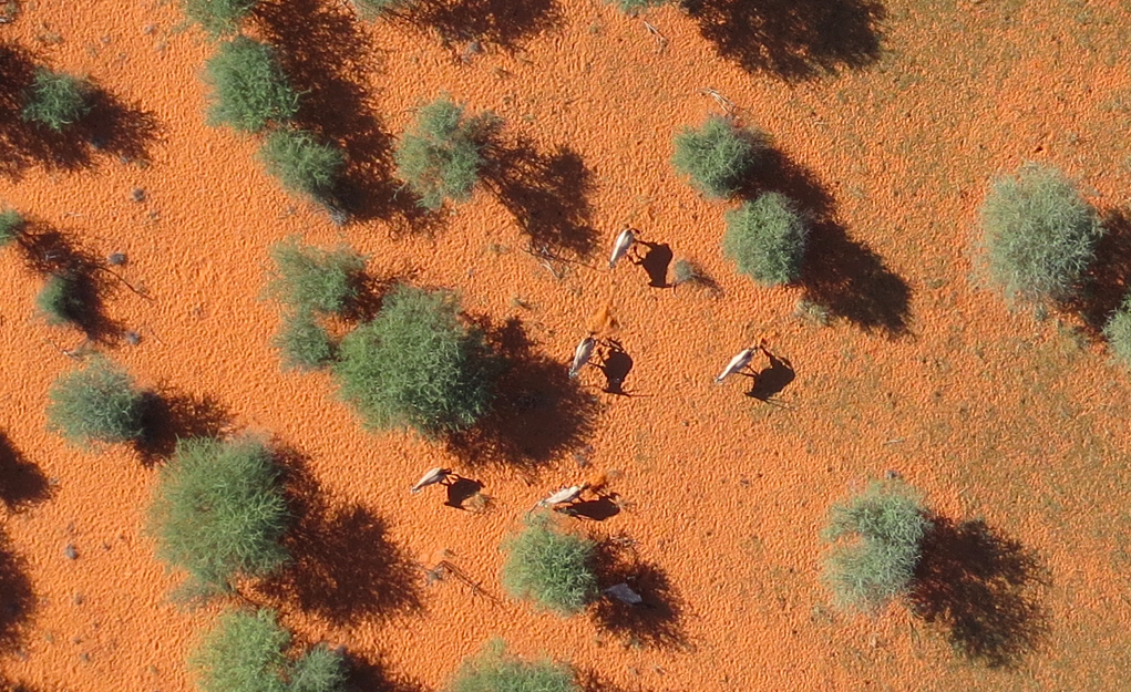
Our very first deployment of MicroMappers for aerial imagery analysis was in Africa for this wildlife protection project. We crowdsourced the search for wild animals in partnership with rangers from the Kuzikus Wildlife Reserve based in Namibia. We were very pleased with the results, and so were the rangers. As one of them noted: “I am impressed with the results. There are at times when the crowd found animals that I had missed!” We were also pleased that our effortscaught the attention of CNN. As noted in that CNN report, our plan for this pilot was to use crowdsourcing to find the wildlife and to then combine the results with artificial intelligence to develop a set of algorithms that can automatically find wild animals in the future.


To do this, we partnered with a wonderful team of graduate students at EPFL, the well known polytechnique in Lausanne, Switzerland. While these students were pressed for time due to a number of deadlines, they were nevertheless able to deliver some interesting results. Their applied, computer vision research is particularly useful given our ultimate aim: to create an algorithm that can learn to detect features of interest in aerial and satellite imagery in near real-time (as we’re interested in applying this to disaster response and other time-sensitive events). For now, however, we need to walk before we can run. This means carrying out the tasks of crowdsourcing and artificial intelligence in two (not-yet-integrated) steps.


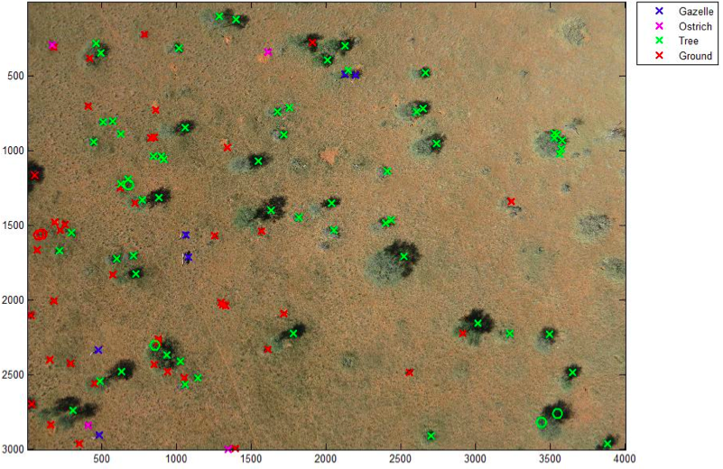
As the EPFL students rightly note in their preliminary study, the use of thermal imaging (heat detection) to automatically identify wildlife in the bush is some-what problematic since “the temperature difference between animals and ground is much lower in savannah […].” This explains why the research team used the results of our crowdsourcing efforts instead. More specifically, they focused on automatically detecting the shadows of gazelles and ostriches by using an object based support vector machine (SVM). The whole process is summarized below.

Screen Shot 2015-02-09 at 12.46.38 AM

The above method produces results like the one below (click to enlarge). The circles represents the objects used to train the machine learning classifier. The discerning reader will note that the algorithm has correctly identified all the gazelles save for one instance in which two gazelles were standing close together were identified as one gazelle. But no other objects were mislabeled as a gazelle. In other words, EPFL’s gazelle algorithm is very accurate. “Hence the classifier could be used to reduce the number of objects to assess manually and make the search for gazelles faster.” Ostriches, on the other hand, proved more difficult to automatically detect. But the students are convinced that this could be improved if they had more time.

Screen Shot 2015-02-09 at 12.56.17 AM

In conclusion, more work certainly needs to be done, but I am pleased by these preliminary and encouraging results. In addition, the students at EPFL kindly shared some concrete features that we can implement on the MicroMappers side to improve the crowdsourced results for the purposes of developing automated algorithms in the future. So a big thank you to Briant, Millet and Rey for taking the time to carry out the above research. My team and I at QCRI very much look forward to continuing our collaboration with them and colleagues at EPFL.

0c8155d.png

In the meantime, more on all this in my new book, Digital Humanitarians: How Big Data is Changing the Face of Humanitarian Response, which has alreadybeen endorsed by faculty at Harvard, MIT, Stanford, Oxford, etc; and by experts at the UN, World Bank, Red Cross, Twitter, etc.

Read more…

ROSsifying an APM-based autopilot

Great stuff happening at Erle Robotics while we push our Linux autopilot, Erle-Brain, towards deeper and deeper ROS integration.

Here's Alex sharing with you some of the first packages we coded (video):

Some links:

- PWM: https://github.com/erlerobot/ros-hydr...
- Buzzer: https://github.com/erlerobot/ros-hydr...
- Ubled: https://github.com/erlerobot/ros-hydr...
- StatusLed: https://github.com/erlerobot/ros-hydr...

Read more…