Sean Tierney writes to let us know that International Drone Day Boston is a little less than a week away...are you going? Check it out http://dronedayboston.com!
All Posts (11086)
Sort by
Stephen Wolfram (Mathematica) wrote to let us know that Wolfram Research is releasing a new service, called Wolfram Data Drop. He thinks it could be a great tool for drone data, and indeed a cool demo is coming soon. In the meantime, you can see his son demonstrating an earlier use of Mathematica for drone data at Maker Faire above (more details on that here).
Here's his blog post explaining it:
So what is the Wolfram Data Drop? At a functional level, it’s a universal accumulator of data, set up to get—and organize—data coming from sensors, devices, programs, or for that matter, humans or anything else. And to store this data in the cloud in a way that makes it completely seamless to compute with.
Our goal is to make it incredibly straightforward to get data into the Wolfram Data Drop from anywhere. You can use things like a web API, email, Twitter, web form, Arduino, Raspberry Pi, etc. And we’re going to be progressively adding more and more ways to connect to other hardware and software data collection systems. But wherever the data comes from, the idea is that the Wolfram Data Drop stores it in a standardized way, in a “databin”, with a definite ID.
Here’s an example of how this works. On my desk right now I have this little device:
Every 30 seconds it gets data from the tiny sensors on the far right, and sends the data via wifi and a web API to a Wolfram Data Drop databin, whose unique ID happens to be “3pw3N73Q”. Like all databins, this databin has a homepage on the web: wolfr.am/3pw3N73Q.
The homepage is an administrative point of presence that lets you do things like download raw data. But what’s much more interesting is that the databin is fundamentally integrated right into the Wolfram Language. A core concept of the Wolfram Language is that it’s knowledge based—and has lots of knowledge about computation and about the world built in.
For example, the Wolfram Language knows in real time about stock prices and earthquakes and lots more. But now it can also know about things like environmental conditions on my desk—courtesy of the Wolfram Data Drop, and in this case, of the little device shown above.
Here’s how this works. There’s a symbolic object in the Wolfram Language that represents the databin:
And one can do operations on it. For instance, here are plots of the time series of data in the databin:
And here are histograms of the values:
And here’s the raw data presented as a dataset:
What’s really nice is that the databin—which could contain data from anywhere—is just part of the language. And we can compute with it just like we would compute with anything else.
So here for example are the minimum and maximum temperatures recorded at my desk:
(for aficionados: MinMax is a new Wolfram Language function)
We can convert those to other units (% stands for the previous result):
Let’s pull out the pressure as a function of time. Here it is:
Of course, the Wolfram Knowledgebase has historical weather data. So in the Wolfram Language we can just ask it the pressure at my current location for the time period covered by the databin—and the result is encouragingly similar:
If we wanted, we could do all sorts of fancy time series analysis, machine learning, modeling, or whatever, with the data. Or we could do elaborate visualizations of it. Or we could set up structuredor natural language queries on it.
Here’s an important thing: notice that when we got data from the databin, it came with unitsattached. That’s an example of a crucial feature of the Wolfram Data Drop: it doesn’t just store raw data, it stores data that has real meaning attached to it, so it can be unambiguously understood wherever it’s going to be used.
We’re using a big piece of technology to do this: our Wolfram Data Framework (WDF). Developed originally in connection with Wolfram|Alpha, it’s our standardized symbolic representation of real-world data. And every databin in the Wolfram Data Drop can use WDF to define a “data semantics signature” that specifies how its data should be interpreted—and also how our automatic importingand natural language understanding system should process new raw data that comes in.


The beauty of all this is that once data is in the Wolfram Data Drop, it becomes both universally interpretable and universally accessible, to the Wolfram Language and to any system that uses the language. So, for example, any public databin in the Wolfram Data Drop can immediately be accessed by Wolfram|Alpha, as well as by the various intelligent assistants that use Wolfram|Alpha. Tell Wolfram|Alpha the name of a databin, and it’ll automatically generate an analysis and a report about the data that’s in it:
Hi, let me introduce my APM mode switch with LCD display.
The basic idea is from Stefan Gofferje's project, thanks on him for PPM stream code part!!!
My idea was to make something more good-looking thing for my transmitter and get rid of annoying switch mixes. My APM mode switch uses an Arduino as main processor. Technically, Arduino generates a PPM stream for the RC transmitter, this can be connected through the trainer port. (Check out your transmitters manual for proper trainer port setup). The desired channel in PPM8 stream can be configured in the sketch (default is ch5).
*** Please note that LCD display will display the actual mode regarding PWM value! ***
***The actual mode in the APM can be different, since there is not any telemetry ***
***feedback in this switch! Take care of proper APM setup!!! ***
***Please double check mode matches on the ground before first take-off!!!***
Here is the parts list:
- Arduino Nano
- 2x16 LCD screen (HD44780 compatible)
- 6 pcs of pushbutton (I'm using these, I think they are quite conventional, for 7mm dia holes)
- 5V buzzer, max. 40mA (optional)
- 10k pot (optional)
- 3D printed body
- upper and lower plates milled from any 1,5 mm GF or CF plate
And this is the connection diagram:
***UPDATE***
***Don't use Arduino Nano's built-in 5V power source because overheating can cause instability!***
***Use a small DC-DC converter instead***
(or supply LCD from another 5V power source)
I suggest to solder the Arduino to the LCD, D2...D5 and D12 are on the same place as in the LCD screen:
Here is the working LCD:
The LCD is mounted inside the body with screws:
The neccessary 3D files can be downloaded from the project's GrabCAD page.
And this is the sketch: APM_mode_switch_NHA_v2_0.ino
Here is a Sample of my screen's diyplay states.
Mode names and sign letters can be edited in this part of the sketch:
I can't upload any images about a completelly assembled switch since I'll use it together with my portable ground station, so I designed a unique case that fits to my GS (so guys, the 3D model above is designed only for you... :) ):


I hope you'll enjoy, and of course,
***USE IT ON YOUR OWN RISK***
***I'll not take care of any damages caused by malfunction or faulty assembly***
Regards,
Adrian
We have just implemented 3D playback with Roll, Pitch, Yaw animation on www.exmaps.com.
We feel that 3D playback will be much better than 2D visualisation. You do not need to reconstruct the flight mentally using roll, pitch, yaw graph nor figure out how did the drone fly via the 2D "spaghetti" created on the 2D map. 3D playback not only shows the path in 3D space but also animates the state of the drone.
It will be easier to
1) see if the plane is indeed flying with nose pointing to line of flight
2) which way the multirotor crash
3) drop in height during flight
and more....
There are some limitations:
1) Might not depict rapid roll/spin movement correctly
2) Might not be compatible with mobile devices and older computers
Heres an interesting high altitude helium balloon plane flight http://exmaps.com/c835c8 done by LOHAN
Do give it a try and let us know what you think!
I don't know much about the RC world, so perhaps this is old news. But it's kind of amazing to watch planes defy gravity.
From BoingBoing:
Barry writes, "There's a thing called pattern flying, where pilots compete to perfectly execute an elaborate set of compulsory tricks."
They do it for real, RC modelers do it, and they do it indoors with planes lighter than a pack of cigarettes. And the Finnish (because of course there's an international competitive scene) team's rocket scientist/Q has invented a cool counterrotating drive that is rocking this secret world. Mesmerizing - a playful robot fish in a huge tank of water.
It's easy to get consumed with all of the design, development, and testing of DIY UAV's. Add to that the daily barrage of "drone" media happenings/hype and it's easy to get in a rut. Sometimes it's nice to just fire up an aircraft and take it for a spin. Nothing like getting a little air into the lungs and "under the props", so to speak. Did just that yesterday and made a little video of a TeensyFly Hexa outfitted with a LisaMX autopilot getting some exercise. "All work and no play ...", well, you know how the saying goes. Enjoy.
Today LightWare Optoelectronics released the SF30/B obstacle detection LRF that updates at an astonishing 36633 readings per second and has a range of 50m in all lighting conditions. The introductory price of the SF30/B is just US$350.
The SF30/B is the latest light weight laser product from LightWare designed specifically for use in unmanned vehicles. It includes both a serial port and analog outputs along with a micro USB port for configuration. The update rate, resolution and baud rates can all be set to suit most types of aerial and ground based applications.
The SF30/B is designed to operate either stand-alone as a conventional LRF or it can form part of a scanning LIDAR system to create two dimensional or three dimensional maps. The very fast update rate of the SF30/B makes it ideal for locating potential hazards along the flight path of a UAV and the 50m range gives the flight controller plenty of time to take evasive action.
Additional products in the SF30 family include the SF30/C with a range of 100m for use in larger UAVs, helicopters and light aircraft. LightWare also manufactures the SF10 range of precision AGL altimeters and the popular SF02 LRF. For more information visit lightware.co.za
Greetings friends! It’s been a few months since we introduced “Backcountry Drones” and the concept of the coaxial “Scout” backpack drone to you here on DIYdrones, and although it may have seemed we’d gone quiet…we’ve been busy. Very busy.
We’ve gotten some amazing input from many of you, feedback that we’ve taken to heart as we’ve worked to design a production-worthy vehicle. Next month we’re going to reveal the fruits of our efforts in a Kickstarter campaign. But before we do, we wanted to get some more input.
We’ve watched with interest as other sUAV designs have met (or even smashed) their funding goals, only to have a slew of unpleasant issues emerge afterwards. We’d like to avoid as many of those as possible. Between the three of us, we’ve got more than 40 years of RC experience, and while we’re really confident in our design and we think you’re going to love it, we want to run some thing by you before we go “really” public. Features of the new model include:
- Stacked two-blade rotor system
- 10cm diameter, 35cm length, about 2.5 lbs
- Pixhawk control
- Mobius HD standard, with interchangeable GoPro module
- Optional FPV
A video highlighting two years of early proof-of-concepts is attached. The production prototype is flying, and we'll be posting photos and video in the coming weeks leading up to the launch of the Kickstarter campaign.
We’ve read all of the comments for the X-plusOne, AirDog and the Zano. Those are some interesting designs with some really great features, and they've had some terrific backers and candid comments. We’re going to do our very best to under-promise and over-deliver when it comes to performance and delivery date. Our control board is well-proven (you’ll agree), and we’re only using aerial footage shot from our vehicle. Without post-processing to remove jello.
But what else? We’d love to get a discussion going here to try to cover as many things as we can before we finalize the details of our campaign. We've posted a video here with footage from our early development. The new model is bigger, more versatile, and more durable...you're going to love it. Thanks for your continued interest and input, and please be sure to visit our new website at www.ascentaerosystems.com!
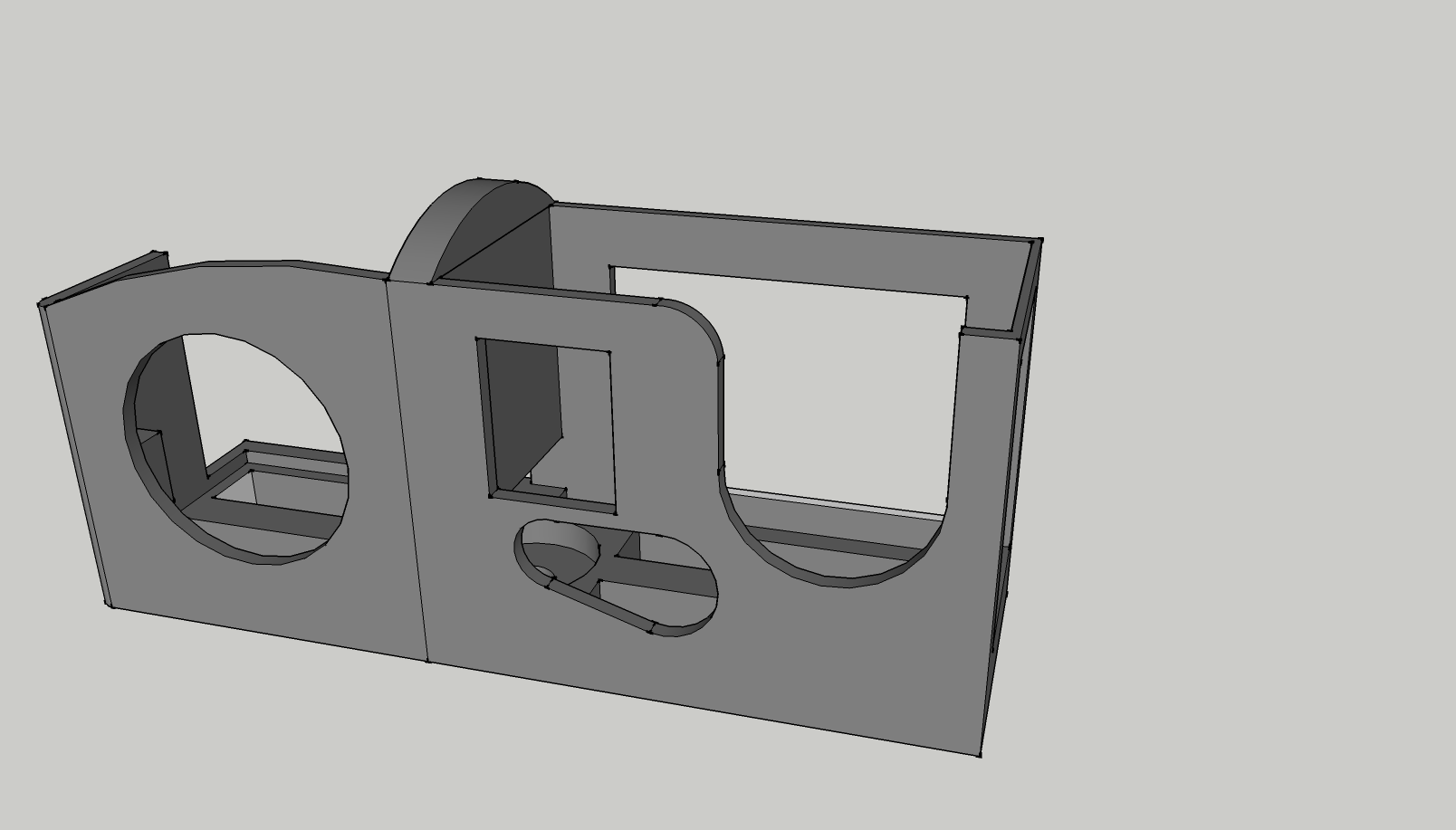
I've been doing a bunch of filming with my Tau2 (more to come on that) and recently I have needed to film with both the Tau2 and a GoPro with the aim of blending the video.
I set about designing a camera case which will house both the GoPro as well as the Tau2 at the same time. My goals were that it needed to be light, rigid and securely hold them.
The 3rd draft of it has worked quite well i think.
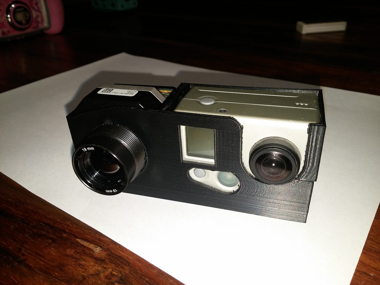
Some enhancements (printing at the moment!) will be:
- Thicker side walls
- A clip over the top to hole them in place (although the fit is so snug only a crash would dislodge them)
Honestly, there is not much more I can want with it. It does what it needs to.
I'll post an update here and on my other blog in a few days once I have printed it and given it a few test flights.
Some sample images from the first flight:
-- Crispin
After many problems with my the infrared trigger to fix sony nex decided not to have problems with my orthophotos.
I modified the trigger of the camera soldering two wires as this website says. http://photoshipone.com/10/sony-nex5n-trigger-modification/
(I'm not having pictures of my installation sorry)
then later connect the two wires to solder on my trigger and connect the output relay of pixhawk.
it set to trigger remote is made through relay with mission planner.
and this is the result!
Rover Release 2.49 is OUT!
We know you love Rovers the most. They don't randomly fly off, they don't fall out of the sky and they don't have nasty spinning props to cut fingers. You can RELY ON A ROVER. Follow the link to come and check out what's new:
Found this Crazyflie clone while doing a Google image search on nano quadcopter controller boards. Has anyone played with this particular unit?
NEJE Gravity Sensor Operated Crazyflie Nano Quadcopter Kit for Android Cellphone - Black $58.25
Color Black
Brand NEJE
Model NJ0001-1
Material HMC
Quantity1 Set
hade Of Color Black
Channels Quanlity 4 Channels
FunctionUp,Down,Left,Right,Forward,Backward,Stop,Hovering,Sideward flight
Gyroscope Yes
Remote control frequency 2.4GHz fps
Remote Control Range10 m
Remote Type Others,Bluetooth
Suitable Age Grownups
Battery Type Li-ion battery
Battery Capacity 350 mAh
Charging Time 20 minutes
Working Time 8-10 minutes
Remote Control Type Android Phones
Remote Controller Battery NumberN/A
Remote Controller Battery Type Others,Android Phone
Certification CE
Packing List
1 x Quadcopter
1 x USB 2.0 FTDI cable ( 28cm )
1 x 350mAh lithium battery
1 x Blank PCBA
1 x USB charging cable ( 60cm )
1 x TF card (Android APK, USB serial driver, testing software)
I showed a tour group of 14-year-old boys how to skywrite with the Tower app today. After they flew a mission, I checked the logs on Droneshare. Sure enough: penis.
Found this for sale on my local Canada Kijiji Classifieds, call Ebay Classifieds in the US.
WW2 Fairchild K-20 Aerial Camera RARE
$180.00
The Fairchild K-20 was an aerial camera made by the Folmer-Graflex Corporation during World War Two. About 15,000 were made from 1941-1945.
t is one of a series of "K" cameras and just about every bomber carried one for documenting strikes, surveillance, and so on. They were also used in light observation planes and may have been in service up through the Korean War
Includes Case, Camera, extra Lens, Lens case
This is best Price you can find
This Camer from Norfolk Naval Station Sticker inside case!
Kijiji Ad with more pictures.

UAVs can support humanitarian action in a variety of ways. Perhaps the most common and well-documented use-case is data collection. There are several other use-cases, however, such as payload transportation, which I have blogged about here, here and here. I had the opportunity to learn more about the logistics and operations of payload UAVs while advising a well-known public health NGO in Liberia as well as an international organization in Tanzania. This advising led to conversations with some of the leading experts in the UAV-for-transportation space like Google Project Wing, Matternet and Vayu for example.
Below are just some of the questions you'll want to ask when you're considering the use of UAVs for the transportation of small payloads. Of course, the UAV may not be the most appropriate technology for the problem you're looking to solve. So naturally, the very first step is to carry out a comparative cost-benefit analysis with multiple technologies. The map below, kindly shared by Matternet, is from a project they're working on with Médecins Sans Frontières (MSF) in Papua New Guinea.

Why does it take some 4 hours to drive 60km (40 miles) compared to 55 minutes by UAV? The pictures below (also shared by Matternet) speak for themselves.


Any use of UAVs in humanitarian contexts should follow the Code of Conduct proposed by the Humanitarian UAV Network (UAViators), which was recently endorsed by the UN. Some of the (somewhat obvious) questions you'll want to bear in mind as you carry out your cost-benefit analysis thus include:
- What is maximum, minimum and the average distance that the UAV needs to fly?
- How frequently do the UAVs need to make the deliveries?
- How much mass needs to be moved per given amount of time?
- What is the mass of individual packages (and can these be split into smaller parcels if need be)?
- Do the packages contain a mechanism for cold transport or would the UAV need to provide refrigeration (assuming this is needed)?
- What do the take-off and landing spaces look like? How much area, type of ground, size of trees or other obstacles nearby?
- What does the typology between the take-off and landing sites look like? Tall trees, mountains, or other obstructions?
- Regarding batteries, is there easy access to electricity in the areas where the UAVs will be landing?
- Is there any form of cell phone coverage in the landing areas?
- What is the overall fixed and variable cost of operating the payload UAVs compared to other solutions?
- What impact (both positive and negative) will the introduction of the payload UAV have on the local economy?
While the payload weight is relatively small (1kg-2kg) for low-cost UAVs, keep in mind that UAV flights can continue around the clock. As one of my colleagues at the Syria Airlift Project recently noted, "If one crew could launch a plane every 5 minutes, that would add up to almost 200kg in an eight-hour time period."

Naturally, Google and Matternet are not the only group out there developing UAVs for payload transportation. Amazon, DHL and others are prototyping the same technology. In addition, many of the teams I met at the recent Drones for Good Challenge in Dubai demo'ed payload solutions. One of the competition's top 5 finalists was Drone Life from Spain. They flew their quadcopter (pictured above) fully autonomously. What's special about this particular prototype is not just it's range (40-50km with 2-3kg payload) but the fact that it also includes a fridge (for vaccines, organs, etc.,) that can be remotely monitored in real-time to ensure the temperature remains within required parameters.
At some point in your planning process, you'll want to map the landing and take-off sites. The map below (click to enlarge) is the one we recently produced for the Tanzania UAV project (which is still being explored). Naturally, all these payload UAV flights would be pre-programmed and autonomous. If you'd like to learn more about how one programs such flights, check out my short video here.

One other point worth keeping in mind is that UAVs need not be independent from existing transportation infrastructure. One team at the recent Drones for Good Challenge in Dubai suggested using public buses as take-off and landing points for UAVs. A university in the US is actually exploring this same use case, extending the reach of delivery trucks by using UAVs.
Of course, there are a host of issues that one needs to consider when operating any kind of UAV for humanitarian purposes. These include regulations, permits, risk assessments and mitigation strategies, fail safe mechanisms, community engagement, data privacy/security, etc. The above is simply meant to highlight some of the basic questions that need to be posed at the outset of the project. Needless to say, the very first question should always be whether the UAV is indeed the most appropriate tool (cost/benefit analysis) for the task at hand. In any case, the above is obviously not an exhaustive list. So I'd very much welcome feedback on what's missing. Thank you!
Looks pretty generic but the fact that they're launching a mag is probably a sign of the times...From Discover:
Whether you’re curious about the ethics of unmanned aerial vehicles in law enforcement or itching to break into the quadcopter hobby, Drone 360 is packed with ideas and information to help you get started!
You'll find:
Everything you need to know to get started with drones, from equipment reviews to FAA flight rules and photography how-tos.
An exploration of the serious side of drones, including military and law enforcement applications, and ethics.
Drones in the news: The curious, the cool, and the truly bizarre.
How drone technology will change search and rescue operations and emergency response.
From Diana Marina Cooper on Robohub:
The FAA’s Notice of Proposed Rulemaking (NPRM) for small unmanned aircraft systems (SUAS) proposes to restrict operations that are completed beyond visual line-of-sight (BVLOS). However, the FAA has invited comments regarding the proposed BVLOS restriction. In Canada, BVLOS operations are not yet mainstream, however they are attainable under the Special Flight Operations Certificate (SFOC) system.
Transport Canada’s Staff Instruction 623-001 establishes the following conditions for BVLOS operations:
- BVLOS flights cannot take place outside of restricted airspace, unless the operator can mitigate risk to an acceptable level i.e. through the use of ground-based radar
- BVLOS flights must not be conducted over populated areas
- BVLOS flights must be conducted in visual meteorological conditions
- BVLOS flights cannot be conducted within controlled airspace
- BVLOS flights can only be conducted within 5 nautical miles of the point of departure
- The take-off and landing/recovery must be conducted within visual line-of-sight
- Direct radio line-of-sight capability must be maintained throughout the operating area
Canada is not alone in having established conditions for BVLOS operations. In fact, quite a few jurisdictions have more advanced regulations for BVLOS operations, including Australia, Colombia, Czech Republic, France, Israel and Poland. As stakeholders submit comments to the FAA over the next two months, it’s important to look at how other jurisdictions are managing risk in BVLOS operations.
Think of the things you could write or draw! It's a software project: https://www.kickstarter.com/projects/946052725/telaero-drone-flight-planner-for-precision-imagery
The next step will be to add multiple LEDs of different colors that can be toggled by the GPIO pins on your autopilot so you can draw amazing 3D structures!
I tripped over this on my suggested links and thought it might be of interest to the DIYD crowd. Fascinating to see an original Macintosh being used as a ground station!
I am Chairing a panel on "Humanitarian UAVs" at the DroneApps & Expo 2015 in Lausanne, Switzerland (September 14-15). This panel will featuring international UAV experts and multiple use-cases of UAVs (imagery capture, payload transportation, etc). We will also have a "Demo Day" where participants will get hands-on introductions to operating UAVs for humanitarian purposes. All the information below is also available here: http://uaviators.org/forum/humanitarian-uav-panel-at-droneapps-conference-expo-2015.
Simon Johnson and Benoit Curdy founded Drone Apps to create an ambient atmosphere where the most outstanding users of the drone industry meet innovators and regulators to discuss or even resolve burning issues of the business that will help the global UAV industry grow rapidly. The event is dedicated to be the Main Stage in the civilian UAV space for elaborating on new ideas and establishing breakthrough partnerships. Drone Apps is expected to have such a fundamental impact, that Google has coined the event “The Davos of Drones”.
The date and venue of the ground-breaking Drone Apps Conference & Expo is
14-15th September 2015
SwissTech Convention Center – Lausanne, Switzerland
We are working very hard to make Drone Apps a unique and unforgettable unmanned aerials systems gathering to meet & share, network & cooperate.
The date and venue of the ground-breaking Drone Apps Conference & Expo is
14-15th September 2015
SwissTech Convention Center – Lausanne, Switzerland
We are working very hard to make Drone Apps a unique and unforgettable unmanned aerials systems gathering to meet & share, network & cooperate.
• Quality participants according to the concept “users meet inventors and regulators”; invitation only, active international members of the sector.
• Independently curated sessions to learn, discuss and share relevant industry opportunities and issues.
• Intimate event: 400 participants, no live streaming, relaxed atmosphere.
• High quality venue for presentations, panels, networking, private meetings and serendipitous moments.
• Professional organisers, moderators and logistics.
The most sought-after Speakers and representatives of specific UAV topics will get on stage in each panel and plenary session.
Why attend Drone Apps if you are interested in drones for humanitarian applications?
• Independently curated sessions to learn, discuss and share relevant industry opportunities and issues.
• Intimate event: 400 participants, no live streaming, relaxed atmosphere.
• High quality venue for presentations, panels, networking, private meetings and serendipitous moments.
• Professional organisers, moderators and logistics.
The most sought-after Speakers and representatives of specific UAV topics will get on stage in each panel and plenary session.
Why attend Drone Apps if you are interested in drones for humanitarian applications?
Because the pass provides instant access to 400 like-minded, far-sighted drone professionals, end-users, and businesses who are keen on listening to you. With your tickets, you can enter to a VIP Club of decision makers related to the global UAV business who are prospective supporters, promoters, partners to your project about the humanitarian application of drones.
Do you have plans and ideas how to do good with drones in humanitarian missions? Share and turn them into reality with your prospective partners at Drone Apps on 14-15th September 2015 in Lausanne!
