All Posts (11086)

Sort by

Andruav SDK


This is my fifth article about Andruav. The new thing about this topic is that it targets Developers more than users.

Andruav-SDK is a jar file that you can use to develop an application with same or more features of that in Andruav App.

Andruav Protocol

Andruav based systems uses web-sockets for communicating with other Andruav-based parties. Communication can take place as broadcast or peer-to-peer. It is very similar to IRC and chat room model, where you can communicate privately with someone or just speak to the whole room. In Andruav world we call them Groups and instead of talking to persons there are Units. A unit can be a vehicle “plane, quadcopter, rover” or can be a GCS “Ground Control Station”.

Andruav Communication Rules

Before we start, we need to define some communication rules for Andruav.

1- Any client connect to server identify itself by AccessCode "account".

2- for each packet the unit has to identify its name and group name.

a. unit name "sender" is a name unique for each account and identifies the unit of GCS.

b. group name "group" is a name unique for each account.

3- Each account can have multiple groups.

4- Each group can have multiple units.

5- Units can only communicate with other units in the same group. no group-to-group communication or account-account communication.

Command Types

command types are either system commands or communication commands. It is a fast way to tell server if it has to parse the message or just forward it to target(s).

system commands are:

add: to subscribe a unit or GCS in a group in an account.

del: to unsubscribe a unit or GCS from a group in an account.

ping: server reply with pong message and using timestamp created by sender the sender can evaluate quality of connection. Can be used to determine some features such as enable/disable video stream, or send a remote warning that there is a communication issue or send SMS as SOS message.

The other command type is communication commands and it has only two commands:

individual: instruct the server to send the message to a single unit. the target unit is found in field "target" and it should be found within the same group. target is extra field that appears only when sending individual messages.

common: instruct the server to send the message to all units and GCS in the same group.

In communication commands, server only acts as router for routing messages. the message field in Andruav command become a major player here. as it contains the actual command or info that is sent to target(s). Also another field appear when sending command called "message type" which is an id of type of command embedded in the message part.

Above attributes are sent in JSON format.

Andruav Messages can be either text or binary. Binary messages are used to carry telemetry data, images and video frames.

Remember you can Extend and Create new commands that fits your need. More information about classes are here.

There is alot to be written for documentation, however please contact me in case you need any support that is not clear in documentation.

How to Run Sample #1 APP

Code & App is on gitHub

You need to install Android APP apk file on two android mobiles.

from above video you need to only enter Access Code & Andruav Unit ID. The first one is a common alphanumeric, and the second one is unique per device.

You might also want to access this for details.

Read more…

3689641964?profile=original

This is really great accomplishment:-)

Montreal, Canada: EnergyOr Technologies Inc., a leading developer of advanced PEM fuel cell systems, recently demonstrated what are believed to be the world’s first fuel cell powered and longest ever duration multirotor VTOL UAV flights, flying for a record 2 hours, 12 minutes and 46 seconds.

http://www.energyor.com/news/post:28

I am not sure the actual battery on this quad.

EPOD EO-310-XLE

Rated Net Output Power:                       310 W
Max. Continuous Net Output Power:       370 W
Peak Net Output Power (Take-off):        1000 W
DC Output Voltage Range:                  32 - 45V
System Efficiency @ 310 W:                     54%
Design Lifetime:                                   1000 Hours
Net Energy Available @ 310 W:             1790 Wh

Read more…
Developer

3689641867?profile=original

The ELC/DroneCode conference is fast approaching. We are really looking forward to meeting many of you in San Jose next week!

We have put together a rough agenda for the 'unconference' and the first physical meeting of the Technical Steering committee on the Wednesday which you can see here:

How to Participate

You can participate in the unconference either by being there in person (if you are going to ELC) or by joining the discussions on mumble. We will use the DroneCode channel in mumble. There will be a microphone in the room and we will also be live streaming via hangouts on air. To actively participate in the discussions you should join the mumble channel. Please be careful to mute yourself when not speaking.

Rough Timetable

As an unconference the schedule tends to be quite loose, but it will be roughly:

8am to 9am: breakfast

9am welcome and introductions

9:15 first presentations and discussions

10:00 to 10:30 break

10:30 to 12:00 more presentations and discussions

12:30 Lunch.

2:00 to  4:00 pm.  afternoon presentations and discussions


If you have other ideas or suggestions for discussion topics please let us know


Read more…
Developer

screenshot.png

In an effort to give back to the DIY community, we have decided to offer our standalone geo-tagging software, SwiftTag, for free. It is meant to work with all camera setups that are triggered by the APM platform. By using a synchronization script with Mission Planner, it is possible to accurately tag every photo taken in flight without resorting to comparing the camera’s internal timestamp against the log of GPS positions.


SwiftTag compares a sync photo to the .log created by downloading the autopilot’s log. It can then tag all the photos, creating a CSV file that can be read by most processing software. The CSV file contains the position as well as the attitude for each photo. SwiftTag also allows filtering of the photos by roll, pitch or yaw values if needed.


SwiftTag was developed to address the existing short comings in tagging photos with the APM platform. By using SwiftTag we have reduced the average local error in our tags from 20 meters to less than 4 meters. Most notably, we used SwiftTag to tag over 40,000 photos taken for a large mapping project. The ground coverage was approximately 60 sq km flown over 9 days with our Lynx M UAS.


For a detailed workflow on how to use SwiftTag, downloads, and FAQ, please visit: swiftradioplanes.com/swifttag

3689643780?profile=original

Read more…
3D Robotics

3689641921?profile=original

Not a surprise for anyone who has tried dealing with VTOL sporks drones, which are easy to take off but very tricky to land precisely in a wind due to the sail wing. From the WSJ:

Google has scrapped its initial drone design because it was difficult to control and is now working on a new version, according to Astro Teller, head of the Internet company’s Google X research lab.

Teller told the South by Southwest conference in Austin, Tex., that Google founders Larry Page and Sergey Brin encourage such failures, so researchers can learn from the mistakes and try different technologies and strategies.

In August, Google unveiled a drone-delivery system called Project Wing that the Internet giant was testing. The prototype had a five-foot single wing that sat vertically on the ground and then turned horizontal after take-off. The design was supposed to combine the benefits of vertical, hovering take-offs and landings with the speed of wing-based flying. In the test, the drones carried supplies including vaccines, water and radios to farmers in Queensland, Australia.

The drone was mechanically simpler than other types of drones, but it was harder to control, Teller said on Tuesday. It didn’t hover well in high winds and its cargo shifted too much when the wing moved up and down, he explained.

Google began working on drones in 2011. It’s not clear when it began experimenting with the single-wing design, but Teller said half the team “knew it was the wrong answer” after eight months. After 18 months, about 80% of the team thought this, he added.

The team debated whether to scrap the design or test it quickly in public. Brin told the team they had five months to make deliveries to real people, which wasn’t enough time to come up with a different design, so the team went ahead with the Australia test with their existing prototype, Teller said.

“Even though Sergey’s five-month thing prolonged the problem, it created an end date for it,” Teller said. “It’s possible without that we would have extended the wrong thing even longer.”

Before the Australia tests, the team was already working on a new design that moves away from the single-wing-based approach, he noted

“They’re now working on that vehicle,” Teller said. He plans an update on the status of this new drone later this year.

Read more…

X-Winder 4-Axis Filament Winder

We've just added an affordable 4-axis filament winder to our line up of desktop filament winders at Xwinder.com  . You can see the 4-axis model 4X-23 operating near the end of this video. Many lightweight and strong model applications for fixed and rotary wing models. We are building a compressed air energy storage fuselage with 3 kilowatt hour capacity (thats 40x 5000 mAh at 14.8v 4S). The Video is here if it does not load in this blog.

Read more…

UgCS 2.3 is out!

3689641662?profile=original

We are happy to launch UgCS 2.3

Due to demand and interest from Spanish speaking countries we have added Spanish language.

To bring more connectivity for your conviniece right inside UgCS application we have added support to Droneshare.com and Mapbox.com

Using UgCS now you can turn your UAV into real time reportes camera as UgCS support streaming to ustream.tv

From UAV flight management most important update is implementation of an option to select Spline, Bank Turn, Adaptive Bank Turn, Stop and Turn turn type.

For rest of the changes please take a look at release notes: http://ugcs.com/release-notes

Have a good flights!

UgCS Team

Read more…
3D Robotics

3689641499?profile=originalAnother clever legal post from Diana Marina Cooper, a lawyer doing some smart writing on the frontiers of robot regulation. FWIW, Canada seems to have confused "autonomous" with "optionally autonomous", which is actually what most modern drones are (they have both fly-by-wire and autonomous modes). From RoboHub:

Chappie, the new robo-film on the block, takes place in Johannesburg, where the police force is made up of robots. In one of the early scenes, the main characters, Die Antwoord’s Ninja and Yolandi take part in a drug deal that is raided by robot cops. Hoping to avoid a similar fate in their next deal, Yolandi suggests that they find the robots’ remote so that they can switch them off like TV sets. Do the robots have a remote? And do Ninja and Yolandi find it? No spoilers here, but let’s take up the underlying question in the context of drone regulations…

What is Canada’s position on autonomous and automated operations? Does your drone have a ‘remote’? If it does, according to Transport Canada, it is not an autonomous drone. Transport Canada defines an autonomous drone as one that does “not allow pilot intervention in the management of the flight.” It is not enough for an autonomous drone to be capable of self-governance, rather it must not allow for any possibility of human intervention.

What about drones that have a remote but can complete automated tasks such as take-offs or landings or that can execute pre-defined waypoint operations? Transport Canada distinguishes these drones from autonomous drones by pointing to the fact that they require operator initiation or intervention.

Although there is no express prohibition, truly autonomous operations are outside of the scope of Canada’s current regulations. For the time being, if your drone doesn’t have a remote, you wouldn’t be able to operate. Our framework permits operations that involve automation, but it requires that an operator have the capability to intervene – or rather, as Ninja and Yolandi would hope – your flying robot must have a remote.

Read more…
3D Robotics

From sUAS News:

To counter the threat of unlawful use of unmanned systems, the Dutch Ministry of Security and Justice, together with the Dutch National Police and the Royal Netherlands Marechaussee, has selected a number of projects in which concepts are developed that can be used to detect, indentify and/or remove these mobile systems in a controlled manner. Project ‘DroneCatcher’ of the Dutch SME Delft Dynamics, is one of the best ideas that has been selected to carry out a feasibility study.

Last week Delft Dynamics successfully completed a range of test flights, which showed that is is feasible to capture drones in midair by shooting a net from another drone.

The DroneCatcher is able to quickly approach the threat. With the help of its onboard camera the netgun can be aimed and fired. Depending on the weight of the system that is to be removed, the DroneCatcher can carry the caught drone and bring it to a harmful place. Alternatively, low impact on the ground is ensured by using a parachute coupled to the net.

With this successful test Delft Dynamics has shown the potential of the DroneCatcher concept and hopes to start a research and development project to improve the system and make it operational.

Read more…

A look inside the DJI factory

This was on the memory card of my inspire 1 quad copter.

I had not seen any other videos like this on the internet so I thought I would share. 

Pretty cool to see more than one employee smiling in a Chinese factory environment.

I wonder what the job title of the guy in the foreground is.

Read more…

Drone color tracking

This is about some experiments I’m doing using python and openCV and of course one of my drones… In this case the drone used for taking the videos, was my hexacopter (Alduxhexa).

The point is to explore different techniques and algorithms to track colours, objects and the follow them using a multicopter. In the video you will see my hexacopter flying with a GoPro pointing always down (to the ground). I want to be able to identify colours on the ground.

drone-color-tracking.png?width=600

There is now lots of similar examples and big projects already doing computer vision with drones, but I just wanted to show you my experiments, share to everyone my code, get some pointers and of course doing some collaboration with people interested.

I'm using:

  • hexacopter
  • gopro hero 3
  • pixhawk
  • tarot gimbal
  • python
  • opencv

This is a picture of my hexacopter used to get those videos:

P1000626.jpg?width=600

My github with the code is here. It contains several more examples, like face detection and so forth... This code works on raspberry pi, mac.

The next step is to make the hexacopter centre and follow an specific target using a extra onboard computer, perhaps a rpi or similar. 

If questions or suggestions don't hesitate in contacting me.

Check my blog http://aldux.net/blog

Read more…

3689641424?profile=original

Hi Everyone,

I'm happy to present the final prototype of DroneThermal micro size analog (PAL/NTSC) thermal camera. 
The project started 3 months ago and we have published some samples on 

our facebook page on 1 March 2015.

After hundreds hours of code work and design changes, the final prototype is ready for production. We signed the agreements with FLIR for Lepton thermal camera cores as well. 

3689641341?profile=original DroneThermal is based on FLIR's low cost 80x60 pixel Lepton camera cores.
Video frame rate and resolution is not much but the price is perfect for civilian small drone hobbyists.
You can pre-order it now, in order to take the advantage of %15 Spring discount.

3689641446?profile=originalComposite video signal resolution is higher than Lepton, so we can resize the thermal image and add some extra information into the video output. ( marking hottest and coolest objects etc. )
Unfortunately radiometry(temperature reading)  looks nearly impossible because of high math and affects of air temperature, thickness, pressure, reflection rate of the objects and camera body temperature. 

I'm working on some cool features , so please share your opinions with me for improvements.

Cheers
Melih

Read more…
Moderator

3689641316?profile=original

VR Spark 350 born after a year full of experiments, where we worked on improving electronic technologies, mechanical design, usability for end user and the possibility to be used for commercial purposes respecting regulation rules that govern the use of drones in the civil aviation world.

We implemented control systems and flight termination to ensure compliance with the Italian and French rules , now start to work on U.S to achieve high levels of safety and reliability. Current configuration with Brushless Gimbal , GoPro 4 and Parachute is 1.3 kg . It has a maximum take off weigh of 1.8 Kg. (3.4 pounds) to take advantage of the imminent FAA and European regulations that will enable smaller drones to fly in restricted areas.

We are currently undergoing experimentation to achieve Italian and French approval for commercial use, and plan to start selling in April.

We are searching partner that want support us for VR Spark Section 333 FAA certification.

for info contact me by skype my account is : virtualrobotix or at my email r.navoni@virtualrobotix.com I'll be present during ELC Technical Showcase in San Jose.

VR Spark 350 main applications are:

  • low budget filmography.
  • safety and rescue.
  • Video inspection  .
  • Marketing (drones branded for promotion - delivery -)
  • Automatic features as  follow me through VR platform Leash. (Action Sports)
  • Photogrammetry.
  • Training schools for professional pilots.
  • Suitable for drones startups company and research projects (eg H2020).

Example of filmografy :

Example of our Flir based Thermal image sensor :

This multi role machine aims to enter as a protagonist in the business services using drones.
It has all the features to aspire to be the Italian answer to the Chinese DJI Phantom. The semplicity and portability of a DJI Phantom, but with so many more payload options and flexibility!

This is last Technical Specification: (Updated) 

  • Innovative Italian Design and special painting technology. 
  • Frame configuration : Multicopter Quad .

  • Propeller:  9x4.5 Option 10x4.5 

  • Motors:  980 KV

  • Time of flight 18 min.

  • Weight : 1.3 kg in full  configuration Gimbal , GoPro 4 Camera and Parachute .

  • Flight Control : VR Brain 5.2 PRO ( VR SPARK CUSTOMIZATION)

  • GPS : VR GPS 8 GNSS dual mode navigation system GPS / GLONASS. until 18 sat and HDOP < 1.5

  • Flight Termination System : VR Flight Stop PRO Power Cutoff + Parachute. 

3689641452?profile=original

Luca ... The Flight Stop work fine ? ... Opsss :) 

  • Radio Link:

    • Primary: SBUS FRSKY X4R

    • Secondary: Flyght Stop : PPMSUM FRSKY D4R

  • Telemetry:

    • FRSKY S.PORT (Telemetry information available on Taranis display LUA Script customizable ) .

    • VR Link 868 / 915 (Mavlink telemetry module)

    • VR OSD - option -  ( Video overlay main telemetry information : attitude , GPS , Battery)

  • FPV Functionality : 
    • CCD camera integrated in the drone .
    • 5.8 Ghz Video TX .
    • Video Switch between the FPV Camera and GoPro 4 .
  • Voltage and Hall effect Current sensor integrated on distribution board.
  • Standard Payload 2 Axis Brushless Gimbal + GoPro 4 Hero Black.

  • PAYLOAD Option Max Weight ( 500 gr)

  • Battery 3S 4000 Mah.

  • Special Drone Code 1st Meeting version support on board RaspberryPi . 


3689637879?profile=original

It is thanks to the work of a large community made up of people with great competence, passion and technological skill that this project has seen the light.

Thanks to Virtualrobotix and the APM:Copter DEV team which has done an excellent job bringing this platform to high levels that was, in its infancy, within the reach of only a few experts.

Now after extensive work on the simplification and usability, so many more professionals can enjoy the flexibility and power of this platform.

for info contact : info@virtualrobotix.com 

original blog post with update : http://www.virtualrobotix.com/profiles/blogs/vr-spark-350-will-be-presented-at-embedded-linux-conference-at-te

Read more…

For Those Who Like Simple

3689641474?profile=original

I bought a 3DR radio from Whitespy to add telemetry to my MultiWii and it works like it should.  Multiwii has a processing program called multiwiiconf that is used to make changes to the PID's and for selecting flight modes and reading and writing to EEPROM.  There is also a slick GUI that adds a few more functions like a moving map.  I've tried both and the "slick" wingui program really uses a lot of memory and processor which my computer can't spare or tolerate without catching on fire.  That was my motivation for seeing what I could do to add a realtime map to the not so resource intense processing multiwiiconf program.  This was easier than I expected.  I searched for mapping programs and libraries already written for processing and found the modestmaps library. https://github.com/modestmaps/modestmaps-processing 

I familiarized myself with the example and armed with the "//" and "/* */", I opened up the source code for multiwiiconf.  My approach was to go through and comment out all the parts that pertained to PID's and graphs.  Generally, I commented out anything that I thought was not related to drawing an attitude indicator, compass or reading the multiwii serial protocol.  I periodically ran the sketch to see what disappeared or if I was too zealous with the comment //'s.  When the only things remaining were the instruments and the com port connection buttons, I added the modestmaps library and minimal code to display a map.  I replaced mouseX and mouseY with GPS_Latitude and GPS_Longitude, and divided those variables by 10000000f to convert to decimal.  That little "f" made a big difference, btw.  Without that I was 30 miles away because of loss of few decimal places.  I also added the little green dot to show current position.  This too came from the modestmaps example. 

I'm telling anyone how to do it instead of posting code, since it's very simple and my code tends to appeal like a dose of clamidia.  One last howto is to make sure to make the same edits in the processing sketch and the java file.  If it's done the way I did it, it should work and look like this.  As the position changes, the map moves with the little green position dot always in the center.    It's not fancy, but it uses about 20% of my CPU instead of 100%. 

  . 

Read more…
3D Robotics

3689641377?profile=original

Oh my. Putting aside the ethics of "unmanned aerial vandalism", I'm a little concerned about the weight of these payloads. I suspect that Tyrone Drone, a modded IRIS+, is a stunt for SWSX rather than a real thing:

TYRONE'S GOT A POSSE. DO YOU?

Trick out your crew with minty fresh or classic crimson Tyrone. Accessorize with a hit and run stencil mount, silly string for your bae or a flamethrower from our torch kit. Control it all with our signature app.

ic_tyrone2_photo.png

MINTY FRESH

app_view.png
Stencil.png
ComingSoon.png
Sillystring.png
ComingSoon.png
FlameThrower.png
Read more…

An autopilot with ROS support

3689641300?profile=original

We've been working towards improving ROS support and creating packages that people can use to build applications. Here's our current status:

Through mavros someone can have control of the autopilot from ROS. Similarly, the pwm, buzzer,statusled and ubled nodes (and topics) give direct access to hardware.

In the following video, Alex provides a walkthrough for some of the packages involved:

Packages are available at our github repositories and documented at the ROS Wiki:

We'd love to hear your opinion about which ROS abstractions you'd like to see in Erle-Brain.
Regards,

Read more…

The Albatross UAV - Ready to Launch

3689641146?profile=original

First and foremost, we need to take a moment to acknowledge the fact that we are here because of you. Plain and simple. We love being a part of this community and have been working tirelessly to make the Albatross a reality for you.

Now that it’s almost there, we thought we would show everyone not only what we are releasing, but also what it took to get here. We have battle tested everything and will start taking orders next week.

It’s this community that drove us to make this happen and we are forever thankful for your support, understanding and continued patience. 

Sincerely,

THE APPLIED AERONAUTICS TEAM

EFFICIENCY

We designed the Albatross UAV to be the most efficient of its kind. That means low stall speeds, high max efficiency, a large cruise window and payload capacity, self cooling fuselage, built in component bays and an entirely electric propulsion system. This equates to less energy expended and more time in the air.

VERSATILITY

Our transformative design allows for dynamic use, making each Albatross truly unique. You can use the Albatross for: search and rescue missions, inspections of pipelines, photography, filmmaking, thermal mapping, 3D terrain mapping, precision agriculture, surveillance, reconnaissance,  humanitarian aid, fun and much, much more!

CAPABILITY

We are committed to integrating efficient design with modern technology in a robust, entirely composite platform. The Albatross is nearly silent, can fly for over 2 hrs, reach speeds of up to 90 MPH and travel for over 100 miles. By upgrading your base airframe to one of our packages you can fly autonomously, capture stunning HD photos and video, complete aerial surveys, monitor crop health, wirelessly transmit live video and increase accuracy with an onboard liar system. 

ACCESSIBILITY

We seek to create solutions that are affordable, efficient and of superior quality. We refuse to accept that affordable means inferior and well built means unattainable. We create professional grade tools at hobby prices.

The wing consists of an optimized foil and a forward swept planform designed to ensure low stall speeds, high max efficiency and a large cruise window. This design also reduces the chance of tip stalling on approach. 

The Albatross wing has a high aspect ratio of 13.6. Although possible to go with a higher aspect ratio, we chose not to. By maintaining our aspect ratio at 13.6, it allows our custom in house foil selection to be tailored for a wider flight envelope. It also allows us to remain within our 3m size constraint, while maintaining adequate wing area.

The wing has two built in component bays allowing for adequate separation of receivers, transmitters and GPS units. 

Finally, the drooped wing tips are designed to reduce drag via the reduction of tip vortices, as well as increase aileron effectiveness at near-stall conditions. 

Our fuselage has a massive amount of usable space. No matter how you want to use the Albatross, the device will never stand in the way of your creativity. 

GoPro Hero 3 & FLIR Tau 2 inside the payload bay

GoPro Hero 3 & FLIR Tau 2 inside the payload bay for size reference

The fuselage was built in a slight trapezoidal shape to minimize fuselage/wing intersection, drag and interference. 

It was also designed to be efficient in cooling. It was designed with a high pressure region in the nose and a low pressure region behind the wing, on top and below the motor mounting area. This acts to create a pressure differential, essentially "pulling" air through the fuselage. The layout allows for smarter cooling, by cooling off lower temperature components towards the front, and higher temperature components in the rear (motor). The cooling exhaust placement was purposely in an area with turbulent airflow, so as to not disturb the otherwise laminar airflow over the rest of the fuselage. Through boundary layer visualization-oil tests, we were pleased to see that under the correct circumstances, we maintain laminar flow over more than 80% of the fuselage. It will be required for the end user to cut their own cooling inlets and exhaust, so they can tailor their cooling requirements for their payload/motor options.

The tail is an inverted V, which improves efficiency while decreasing drag. This V shape is also naturally more stable in banked and coordinated turns. 

Finally, it allows for a twin tail boom design and large diameter prop, while also raising ground clearance of the tail on landing and takeoff. 

The number one reason for keeping airframes small is due to transportation and storage. The Albatross UAV is designed to be easily taken apart and stored. Not only does this make things easier for the end user, but it also reduces shipping costs door to door. 

Our Albatross packages take the leg work out of selecting the best possible components for your airframe. Every package we will offer is made up of products we've built, designed, and/or tested first hand. We only supply genuine top quality components made by the industries leading companies with our Albatross UAV. 

The Albatross was built to support: 

ENDLESS APPLICATIONS

One of the core motivators behind the Albatross was to create an airplane with limitless capabilities no matter the climate or terrain. We designed the Albatross to have professional capabilities without the professional price.

The Albatross is a UAV in all aspects of the word. By upgrading our preferred base airframe to one of our kits or RTF models, it can takeoff, fly and land autonomously via predefined flight paths. It can survey property, take extremely high quality photos and video. It can complete long distance and duration surveys, inspect property and assets. It can assist fire fighters with onboard thermal cameras. The possibilities are endless. 

It's important to note that agriculture is a huge interest of ours. This is primarily because we are certain that our platform has the ability to dramatically simplify the lives of farmers saving them time and money. By monitoring the health of crops in real time with the Albatross, you can assess changes based on growing techniques on a daily or weekly basis. This is all data that can be collected continuously and easily with the aid of an onboard NDVI camera.

SUPERIOR PERFORMANCE

We are committed to marrying this versatility with superior performance. We were determined to create an airplane that could travel for substantial amounts of time at useful speeds. If it was too fast, the data collected would become useless (blurred, inaccurate). If it was too slow, the distance covered would be insignificant. A useful cruise speed and window were a necessity. This is where careful design, planning and testing played a critical role. What we ended up with was an aircraft that can cruise efficiently at 17-20 m/s (38-45 MPH) with a top speed approaching 40 m/s (90 MPH). 2 hours of airtime is easily attainable at these speeds. With fine-tuning we anticipate that this number will grow substantially. 

Finally, The Albatross is nearly silent. Yes, it’s an electric plane which helps tremendously, but with the low RPM motor coupled to a high pitch prop, and little to no turbulent air noise (often a result of draggy airframes), it doesn’t take much before you can’t hear it at all.

Completed November 2013

Completed November 2013

Completed March 2014

Completed March 2014

Completed & Tested April 2014

Completed & Tested April 2014

Completed & Tested June 2014

Completed & Tested June 2014

Completed & Tested October 2014

Completed & Tested October 2014

Completed & Tested December 2014

Completed & Tested December 2014

Completed & Tested January 2015

Completed & Tested January 2015

Completed & Tested February 2015

Completed & Tested February 2015

Our custom built tablet ground station gives you the ability to monitor onboard flight telemetry information, execute autonomous flights as well as control and alter aspects of the flight in real-time. These aspects include, adding waypoints, flying to specific areas and loiters, photography with an onboard camera, returning to your takeoff location and autonomous landing.

The ground station has an 8 core processor, a GPS unit built-in so that your UAV can follow you, 2GB of ram and 16GB of onboard memory with expandable storage thanks to the micro sd card slot on the side. The unit also has the ability to use a sim card for up to 3G wireless service or you can use its built in wireless b/g/n capabilities.

The screen is a 9.7” 10 point capacitive touch screen with a resolution of 2048 x 1536 giving it a clarity and resolution matching the same quality as a new iPad.

Our ground station tablets come preloaded with custom software. This software is provided to us for free. For every tablet ground station sold, we will make a $5 donation to the developers to thank them for their hard work and generosity.

Our two-screen ground station has been in development for over a year. We have completed and tested several prototypes, and what we ended up with was one rugged, capable and self-contained package. 

Our ground station has a 1500 nit daylight readable 19” screen in the top panel of the case, and a 1000 nit daylight readable 15” touchscreen on the bottom panel. This is powered by an Intel Dual Core 1.86ghz computer, with a 64GB solid-state drive and 4GB of ram.

Wireless networking is present and multiple USB ports are panel mounted. It also contains a Windows based computer for running necessary software for automated flights and real-time data telemetry as well as an additional screen to view a live video stream at the same time. Analog video-in is also included viewable on the PC under various mission planning software applications or by using one of the various video inputs to display video on one or both screens. The PC can be viewed on the top screen as well, so there is no shortage of screen space. We were also sure to add a small space in the panel, which is perfect for housing your preferred video receiver.

We’ve added a video out that is routed to both the top screen and PC for ease as well as a power plug within the space for convenience. We also routed a low loss coaxial cable to the top panel so that your antenna of choice can be mounted effortlessly. On the opposite side of the top panel, there is an additional USB port for telemetry connection and ideal antenna placement.

The ground station has 2+ hours of battery life at full brightness, and external power inputs are panel mounted. 

Need to take aerial photos for surveying purposes, inspecting assets or detecting crop health? Simply looking to take high quality aerial photos? You may want to consider this product. 

When an airplane is not perfectly level you can end up with crooked and inaccurate images, forcing you to redeploy your UAV for a second pass. A Flat Mapping Gimbal corrects this. 

Mounted into the bottom of the fuselage and compatible with just about any camera, this downward facing gimbal keeps your camera parallel to the ground through banking turns, takeoff, ascent, descent and and landing. No matter how you fly, rest assured that your photos will always turn out.

To offer the most reliable, high quality yet cost conscious system we could, we spent considerable time looking at how the core operation works from start to finish. We tested ideas and systems that we thought were ideal as well as open sourced projects that our community as a whole helped design. After all, we find that through a collective effort on these endeavors progress is made much quicker. To that end, we wanted to offer commercial grade components where they were needed but not where they weren’t. The overall package results in the best of both worlds, a robust, highly capable system that is constantly updated, as well as extremely cost conscious given its abilities. We used diversity antennas on both our transmit and receiving units and a small form factor and ability to change antennas that are suited to your exact needs in a moments notice. We also utilize antennas operating at alternate circularly polarized directions (LHCP and RHCP) on both the ground and air units to maximize the diversity setup and antenna separation as we are using a MIMO type setup. High definition video is possible with no more than ~100-130 ms latency.

THE APPLIED AERONAUTICS TEAM

Read more…

anbwuhwkaub3gyfvhddr.jpg

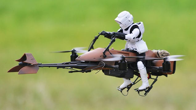
Inspired by that wonderful scene in Return of the Jedi where Luke and Leia race through the trees of Endor using speeder bikes, there's a small group of enthusiasts who do the same thing using camera-equipped remote control drones. Like Adam Woodworth who decided to take his hobby one step further by building a quadcopter that looks exactly like a stormtrooper riding a speeder bike.

IMG_20150311_085646810_HDR.jpg?zoom=2&fit=620%2C1200

IMG_20150308_144700312_HDR.jpg?zoom=2&fit=620%2C1200

IMG_20150307_193449488_HDR.jpg?zoom=2&fit=620%2C1200

source & more:

http://toyland.gizmodo.com/a-star-wars-speeder-bike-quadcopter-looks-perfect-racin-1691311767

more details:

http://makezine.com/projects/fpv-star-wars-speeder-bike-quadcopter-puts-you-in-the-drivers-seat/

Read more…