All Posts (11086)

Sort by

Percepto App Contest Vote

3689643932?profile=original

Thank you all for submitting so many great ideas in our drone app contest. There were so many submission it was really hard to pick just 10.

What we looked for when picking the App ideas:
1. Ideas that will enable new drone functionality and will unlock new use-cases.
2. Ideas that will enable new creative and recreational use for drones.
3. Ideas that can be used as building blocks for various other drone applications

So with the final 10 app ideas listed below, we open up the voting to the public for you to choose which idea you like best, and want to see how it becomes a reality!

#1 Sky Painting

An app that will enable the planning and execution of amazing writing in the sky, like “marry me” signs made by airplanes. The user will be able to plan the desired string of text or drawing and the drone will perform it.

#2 Home & Roof Maintenance

An app will allow users to utilize their drone to view and scan hard to reach places around their home. Percepto will be used to fly in close proximity and follow the edge of a roof or a wall looking for potential problems. This is a feature that GPS is not accurate enough to allow.

#3 Hand Gesture Control

An app that uses Percepto to understand the user's hand gestures and translates them into control commands. The user will then be able to control the drone in the same way a conductor does with an orchestra.

#4 Land It

An app that can perform a landing procedure without any pilot input. It will assess the condition of the landing area, calculate the appropriate path for the final approach, taking in to account the angle and terrain of the landing zone, as well as relative wind, moving objects on the ground and obstacles in vicinity to the landing zone.

#5 Virtual Gaming

The app will display virtual gates as overlay in the live video feed, especially for low riding quads (typically 250 quads such as the Lumenier 250 or BlackOut Mini H). This will allow to turn any open field into a racing track. The virtual racing track can be shared among multiple pilots so they can race together and simultaneously on the same track. Lap times will be shown on HUD (ie as overlay as well). Other flying quads, when having a rear led of a specific color, will be identified by Percepto and a box or shape overlay will be display on the live feed as well.

#6 Picasso's Bull (Long Exposure Photography)

This app would be for long night exposure shots of a Percepto lit with different LEDs. You could import flight paths to the app that would control both the drone and the lighting. The flight path could be repeated with different colors or altered to add different elements to the exposure. In the end, you could have a long exposure of amazingly lit designs akin to night sky writing or Picasso's famous bull drawn in light.

#7 Map-Lock-Track

With this app the drone could map all the moving objects in a specific area, e.g. a street, and send them back to the operator. The operator would then select an object for the drone lock on. The drone would then follow that object. This could be used by search and rescue or law enforcement.

#8 Shark Spotting

An app that can be used around the world for shark spotting and beach safety. Generally a shark can be spotted quite easily from the air and with their size, shape and generally a similar color, I'm hoping I could try develop Percepto to recognize any sharks in a bay during regular flyovers throughout the day. If it spots a shark it would then alert beach authorities via text or a call using a SIM card add-on giving them a snapshot and GPS coordinates (and battery life pending) it would hover/flyover over the shark to provide them with a visual feed location of sharks location.

#9 Sign language

Not really related to the drone world, but can be done only with the computer vision technology. The app will use Percepto to translate sign language to into written text and voice.

#10 Visual Navigation

Performing navigation using landmarks and visual signs that are automatically recognized using Percepto's computer vision camera.

Link to the voting form.

Thank you for giving us some great ideas and lots of inspiration.... GOOD LUCK!!

Our Indiegogo campaign is still live, please share and support.

Read more…

With all the emphases today on energy conservation and the impact of human activities on the environment, we need efficient tools for monitoring such impacts becomes more important than ever. One of that tools is thermal imaging system. Especially then in cooperation with the drone or UAV.

There are a lot of applications of thermal imaging in the area of environment and agriculture. For instance:

  • detect moisture-related problems in roofs [1],
  • monitoring and evaluation of water resources [1], [2],
  • evaluate energy efficiency problems [1],
  • environmental analysis [1],
  • lake morphology [1],
  • survey populations of several wildlife species [3],
  • land coal mine detection [4],
  • underground coal mine fire,
  • forest fire detection,
  • heat budget of soils,
  • detecting insect attack diseases,
  • water stress,
  • salinity stress on vegetation,
  • and much more...

Thermal imaging system in combination with personal drone is a very powerful tool that can perform the necessary measurements quickly and significantly cheaper than using a helicopter. That's why Workswell company developed hightech thermal vision system for drones.

In the video, which is shown above, there is a short record of land mine detection. Workswell Thermal Vision Pro with resolution 640x512 px and thermal sensitivity 50 mK is used. Much more videos we will bring in the following blog posts.

As Workswell company, we can offer both: standalone thermal imaging system, thermal imaging system mounted on a gimbal. But we are nothing without our partners, there for we are looking for new partners. So if you are drone entrepreneur and you like Workswell thermal imaging system, we would like to cooperate and offer to customers one of the best thermal imaging system.

Also feel free to follow us on Twitter or FB.

Thank you very much to our partner Vertical Images from photos.

References

Read more…

brain-v1.1-focus.png

I’m delighted to introduce Erle-Brain v1.1 as the most complete Linux autopilot:

3 (1)

Erle-Brain is being adopted by schools, universities and research centers around the world.

The journey of Erle-Brain started back on late 2013 with the BeaglePilot project giving birth of the first APM Linux-based drones and finishing up with the publication: “Towards an Open Source Linux autopilot for drones“.
Much has happened since and the BeagleBone Black was just featured at the Embedded Linux Conference as a great platform for building Linux drones.


Our love for Linux drones however goes far beyond making them fly and accomplish autonomous missions. As roboticsts we are already thinking about embedding more intelligence in our flying robots (obstacle avoidance, SLAM, image and speech recognition, …) and for that we are putting a lot of development time into the Robot Operating System (ROS). We are releasing demos such as this one. Expect more to come.

Just a few days ago we decided to launch a crowdfunding campaign: BeagleUAV. Through BeagleUAV, you’ll be able to access all the Erle-Brain for a discounted price of 150 €.

Go ahead and get yourself into Linux drones with the BeagleBone Black and the PixHawk Fire Cape ;).

Read more…

 Hi, dear Diydrones members, today I’m happy to demo yet another raspberry based Ardupilot compatible flight controller expansinon board design.


3689643827?profile=original

Features:

  • Pixhawk compatible Power/GPS module interface
  • Integrated ublox m8n GNSS module
  • CSI camera ribbon compatible PCB profile
  • PX4IO forked project for dedicated PWM I/O with STM32 MCU
  • Emlid™ Navio+ inspired solution for ardupilot HAL
  • FULLY open source software and HARDWARE


Goals:

  • Single package for FPV solution
  • Yocto distro with minimum firmware footprint
  • Deliver in May, 2015


Why we did this because we believe in open sourced project will be a great tool to learn from the best, and to be even better. We are young Chinese engineers, please no stereotype.


I’ve been assist @zhangkaiqi working on this project for a while now. We had a breadboard wiring prototype flying happily now and we want to push this endeavor a litter further. As earlier Navio+ test reports from Emlid shows that PWM consumed about 20% of RPI B+’s cpu time, we want to test another solution by putting PX4IO (pixhawk’s co-processor part) on RPi.And we are inspired by @PatrickDuffy’s (Diydrones member, not twitter) FPV solution on Rpi with ubnt™, so we want to build a flight controller has all the good features we can get from a Rpi, so we combined them together.

Today we have the first PCB design sign-offed to the fab, and later this week hope to have a smoking test (first time power on a PCBA). We hope people with talent to join us with software design process and we hopefully to send some samples to volunteered engineers, testers and early bird costumers.


We promise to open source all project files, including Eagle Cad schematic/layouts, after we have the first batch PCBA running complete. We need initial product generate some revenue to support out later developments.


I’ll update this thread for the project, please commit for your ideas and feature request.

Thanks for people who contributed to this community made this possible. 

Read more…
3D Robotics

Congrats to our friends at the Syria Airlift Project, who conducted an experimental project this weekend in Sacramento to train refugees to use Pixhawk-powered fixed-wing drones to deliver supplies into conflict zones. From the video description:

On March 28-29, 2015, Uplift Aeronautics trained a group of Arab-Americans--including refugees from the conflicts in Iraq and Syria--to operate a fleet of four Waliid UAVs for medical deliveries to inaccessible populations. Families took part in every activity, from packing cargo and making parachutes to running preflight checklists and operating ground stations. You can learn more about our project and donate at syriaairlift.org. 

Uplift Aeronautics is a nonprofit corporation (501(c)3 status pending) with a mission to empower and aid communities through innovative aviation technology.

This video was filmed and produced by Retrospect Productions at http://retrospectproductions.com.

Read more…

Xiaomi Yi: Mobius Killer?

3689643689?profile=original

This week we see the release of a new low-cost action cam. Some think it is the next progression of the trusty Mobius camera. I am in the process of performing a written account of the camera and it's features, abilities and performance; also showing how to update the app & firmware to allow more features. 

It's still early days to know if it can do USB-AV-out like the mobius, but it is looking promising.

Why this camera? It potentially has all the features of the Mobius camera, but with a wifi enabled, 1080p 60fps & 720p 120fps at a £50/$80USD price point. Crazy days huh?

If you would like to know more about my experiences they are written here: http://dalybulge.blogspot.co.uk/

Updates will be added as they arrive.

Many thanks

*Update*
It does have AV-out feature:


https://youtu.be/G0vTye84lnw

Read more…

3689643747?profile=original

Researchers from the Robotics and Perception Group from the University of Zurich, developed a new technology that allows a quadrotor to automatically recover and stabilize from any initial condition without relying on external infrastructure like GPS. The technology allows the quadrotor system to be used safely both indoors and out, to recover stable flight after a GPS loss or system failure. And because the recovery is so quick, it even works to recover flight after an aggressive throw, allowing you to launch a quadrotor simply by tossing it in the air like a baseball.

More info: Robohub & Robotics and Perception Group, University of Zurich.

Read more…

3689643753?profile=original

IR-LOCK has been testing the latest version of our sensor/beacon hardware for precision landing, and the results are great! With an IRIS+, we achieve reliable landings at around 5-30cm from the target beacon.

Our development focus is on the reliability and accuracy of the sensor/beacon hardware, and optimal integration with control systems. One feature of the new beacon design is a modulated signal that enables the sensor to avoid false detections. Also, it can be powered by a standard 12V power adapter. 

An obvious next-step is to integrate the beacons into a charging pad/station, or other small landing surfaces. A primary goal of the technology and hardware development is to enable fully-autonomous and remotely controlled systems of quads ... Imagine never changing a battery again :) 

If you want to stay updated on the progress, feel free to sign up at our website. You can also find more details there. 

http://precisionlanding.irlock.com

We are currently running a modified version of ArduCopter. Many thanks to the Diydrones and Drone-discuss community of developers! I don't know how to thank you enough. 

Best,

Thomas

Read more…
3D Robotics

3689643654?profile=original

From The Guardian

Amazon is testing its drone delivery service at a secret site in Canada, following repeated warnings by the e-commerce giant that it would go outside the US to bypass what it sees as the US federal government’s lethargic approach to the new technology.

The largest internet retailer in the world is keeping the location of its new test site closely guarded. What can be revealed is that the company’s formidable team of roboticists, software engineers, aeronautics experts and pioneers in remote sensing – including a former Nasa astronaut and the designer of the wingtip of the Boeing 787 – are now operating in British Columbia.

The end goal is to utilise what Amazon sees as a slice of virgin airspace – above 200ft, where most buildings end, and below 500ft, where general aviation begins. Into that aerial slice the company plans to pour highly autonomous drones of less than 55lbs, flying through corridors 10 miles or longer at 50mph and carrying payloads of up to 5lbs that account for 86% of all the company’s packages.

Amazon has acquired a plot of open land lined by oak trees and firs, where it is conducting frequent experimental flights with the full blessing of the Canadian government. As if to underline the significance of the move, the test site is barely 2,000ft from the US border, which was clearly visible from where the Guardian stood on a recent visit.

The Guardian was invited to visit Amazon’s previously undisclosed Canadian drone test site, where it has been conducting outdoor flights for the past few months. For the duration of the visit, three plain-clothed security guards kept watch from the surrounding hills.

Amazon’s drone visionaries are taking the permissive culture on the Canadian side of the border and using it to fine-tune the essential features of what they hope will become a successful delivery-by-drone system. The Guardian witnessed tests of a hybrid drone that can take off and land vertically as well as fly horizontally.

The company’s decision to set up camp in Canada, after frustration in its attempts to persuade US regulators to allow it to launch its drones in Washington state, takes Amazon’s quarrel with the federal government to a new level. Last week a senior Amazon executive appeared before a US Senate subcommittee and warned that there would be consequences if federal regulators continued to act as a drag on its ambitions to launch a drone delivery service called Prime Air.

What Paul Misener, the company’s vice-president for global public policy, did not tell senators was that at the very moment he appeared before them, Amazon drones were buzzing in the skies just north of the border.

The company wants to offer its customers the ability to have packages dropped on their doorstep by flying robots within 30 minutes of ordering goods online. With innovation in the drone sector reaching lightning speeds, Amazon said it was not prepared to curtail its ambitions because of what Misener said was a lack of “impetus” on the US side of the border.

“We think that this new technology will provide huge benefits for our customers, who we think will love it, and for society more broadly,” he told the Guardian a day after the subcommittee hearing. “Why would we wait?”

Gur Kimchi
Pinterest
 Gur Kimchi is the architect of Prime Air, Amazon’s planned domestic drone delivery service. ‘We do what’s necessary,’ he said. ‘We go to places where we can test outside.’ Photograph: Amazon

Gur Kimchi, the architect and head of Prime Air, said the hope had always been to develop the drone service in the US, close to the company’s Seattle headquarters. “But we’re limited there to flying indoors and have been now for a very long time. So we do what’s necessary – we go to places where we can test outside, in this case Canada.”

Drone technology is seen by many tech companies and aeronautics experts as the next frontier for innovation, with billions of dollars potentially in the balance. Traditionally, the US has been at the vanguard of both tech and aviation innovation, but the approach of the the Federal Aviation Authority (FAA), a US regulatory body, has been markedly tentative so far compared with that of regulators in Canada and Europe.

Brendan Schulman, a New York-based specialist in drone law, said the Guardian’s disclosure of Amazon’s Canadian airstrip-in-exile should be a “serious wake-up call to politicians and regulators”.

“America has led the world in aviation development,” he said, “but for the first time in history we are at risk of losing out. To see one of our most innovative companies forced over the border is a stark example of the danger.”

Until it opened its Canadian base, Amazon had been limited to indoor testing in its Seattle laboratory, backed up with research outposts in the UK – in Cambridge – and Israel. Requests by the company to begin outdoor testing on company land in Washington state have so far largely been rebuffed by the FAA.

The federal agency recently published its guidelines for commercial use of small drones. The new rules will take at least two years to come into effect, a delay which Amazon finds unacceptable.

Last July, the company applied for a so-called 333 exemption that would allow it to carry out outdoor experimentation immediately. Eight months later, the FAA has not responded.

The federal body did agree last week, amid considerable fanfare, to award the company a so-called “experimental airworthiness certificate” that can be used to test a specific model of drone. But it took so long for the certificate to come through that by the time it was granted, Amazon said it was obsolete.

“The pace of innovation is so great at this point that our designs are changing very quickly,” Misener told the Guardian.

The contrast between the relative rigidity of the FAA’s approach to drone testing and the relatively relaxed regulatory regime in Canada is startling. Under the Canadian system, Amazon has been granted a virtual carte blanche regarding its entire fleet of drones within its designated airspace, having gone through a licensing process that took just three weeks.

By comparison, it takes the FAA many months to grant approval. Sources familiar with the process told the Guardian the US regulator insists on an initial 23-page application, a review of 75 pages of further documentation and a four-hour presentation at FAA headquarters followed by a three-hour site visit, together with ongoing reporting and record-keeping obligations.

Early experiments in Canada have focused on a range of individual drone capabilities: sensors that can detect and avoid obstacles in a drone’s path; link-loss procedures that control the aircraft should its connection with base be broken; stability in wind and turbulence; and environmental impact. Once each of these facets has been perfected, a new Amazon prototype drone will be assembled that Kimchi predicted would be utterly safe and wholly unlike anything seen before.

“We are going to end up with unique shapes, unique vehicles. The most important part is to develop strong confidence that our system is safe and that we can demonstrate that to customers,” he said.

“You can build a very different world. It can be faster, and safer, and more economic and more environmentally friendly – all of those things, all at the same time.”

FAA – a uniquely difficult job?

Amazon drone A now outdated iteration of an Amazon domestic delivery drone. The company keeps its new models strictly under wraps. Photograph: Amazon/EPA

The FAA argues that the US has a uniquely difficult job in safeguarding the nation’s skies. It emphasises that it is responsible for the largest, most complex airspace in the world, which, unlike other countries’, is used by a large general aviation fleet.

“Different laws and regulatory structures in other nations may allow them to act more quickly to approve certain UAS [drone] operations,” an FAA spokesman told the Guardian. “Everything we do is safety-oriented, and we base our approvals for unmanned aircraft operations on an assessment of the risks to other aircraft and to people and property on the ground. We have been working diligently with Amazon to get the information we need.”

Misener said he respected the FAA’s desire to keep America’s airspace as safe as possible. “That’s our top priority in Amazon Prime Air too,” he said.

But he questioned the FAA’s portrayal of America’s unique position: “The US does have a complex airspace, but it’s no more complex than in Europe, where regulators do allow testing, and it’s certainly not complex beneath 500ft or in rural areas of Washington state where we had planned to operate.”

The numbers speak for themselves. The FAA has received more than 750 requests for outdoor drone testing licenses from American businesses, Amazon’s among them, but so far has granted just 48. Canada’s equivalent civil aviation authority, Transport Canada, released 1,672 commercial drone certificates last year alone.

Diana Cooper, head of drones and robotics at the Canadian law firm Labarge Weinstein, said that in recent months several US companies had contacted her to inquire about opportunities in her country – a phenomenon that she believes will be boosted further by Amazon’s decision to join the fold.

“Amazon will definitely be a trendsetter,” she said, “and will result in a lot of other large American companies like Google and Facebook looking at our market as well.”

Another battle is already on the horizon. The FAA has stated bluntly it does not believe that drones can be flown safely under their own autonomous control, and is insisting that humans must keep them within eyesight at all times. That is a deal-breaker for Amazon Prime Air, which could only function if drones were able to fly well beyond visual line of sight.

Here too, the contrast between the uncertainty of the US regulators and the can-do attitude of their Canadian and European equivalents is striking. A huge area of Alberta covering 700 square nautical miles of restricted airspace has already been set aside to allow for drones to be tested beyond visual line of sight. In Europe a similar facility is being opened in Wales.

Misener believes that with such opportunities exploding beyond US borders, it is only a matter of time before the FAA is forced to accept that drones are here to stay.

“This technology is going to work,” he said. “It’s coming.”

Read more…
300km

Be careful with LiPos

3689643641?profile=original

This fire in my home town is suspected to have been started by a LiPo. (Though that hasn't yet been confirmed by the fire investigation authorities.)

"A neighbour, who didn’t want to be named, says Les is a member of the Nelson Model Aero Club."

Thankfully the occupants are both safe, and fully insured, but boy they were lucky to get out alive. Imagine if this happened at night when they were asleep.

I store my LiPo's in fire proof bags in the house. I'll store them in fire proof bags in the garden shed from now on.

http://www.stuff.co.nz/nelson-mail/news/67536649/Intense-blaze-destroys-pairs-home

http://nelsonlive.co.nz/news/2015/03/fire-destroys-stoke-couples-home-2/

Read more…

WP1

Above: Aéroport de Port Vila - Bauerfield International Airport. As we land, thousands of uprooted trees could be seen in almost every direction. Below:Massive roots were not enough to save these trees from Cyclone Pam. The devastation reminds us how powerful nature is.

WP2

WP3

WP4

After getting clearance from the Australian Defense Force (ADF), we pack up our UAVs and head over to La Lagune for initial tests. Close collaboration with the military is an absolute must for humanitarian UAV missions. UAVs cannot operate in Restricted Operations Zones without appropriate clearance.

WP5

We're in Vanuatu by invitation of the Government's National Disaster Risk Management Office (NDMO). So we're working very closely with our hosts to assess disaster damage and resulting needs. The government and donors need the damage quantified to assess how much funding is necessary for the recovery efforts; and where geographically that funding should be targeted.

WP6

Ceci n'est pas un drone; what we found at La Lagune, where the ADF has set up camp. At 2200 every night we send the ADF our flight plan clearance requests for the following day. For obvious safety reasons, we never deviate from these plans after they've been approved.

WP6b

Unpacking and putting together the hexacopters can take a long time. The professional and certified UAV team from New Zealand (X-Craft) follows strict operational check lists to ensure safety and security. We also have a professional and certified team from Australia, Heliwest, which will be flying quadcopters. The UAV team from SPC is also joining our efforts. I'm proud to report that both the Australian & New Zealand teams were recruited directly from the pilot roster of the Humanitarian UAV Network.

WP7

WP8

WP11

WP9

WP10

The payload (camera) attached to our hexacopters; not exactly a GoPro. We also have other sensors for thermal imaging, etc.

WP12

Programming the test flights. Here's a quick video intro on how to program UAVs for autonomous flights.

WP13

Night falls fast in Vanuatu...

WP14

WP14b

… So our helpful drivers kindly light up our work area.

WP15

After flawless test flights; we're back at "HQ" to program the flight paths for tomorrow morning's humanitarian UAV missions. The priority survey areas tend to change on a daily basis as the government gets more information on which outlying islands have been hardest hit. Our first mission will focus on an area comprised of informal settlements.

WP16

WP16b

Dawn starts to break at 0500. We haven't gotten much sleep.

WP17

At 0600, we arrive at the designated meeting point, the Beach Bar. This will be our base of operations for this morning's mission.

WP18

WP19

The flight plans for the hexacopters are ready to go. We have clearance from Air Traffic Control (ATC) to fly until 0830 as manned aircraft start operating extensively after 0900. So in complex airspaces like this one in Vanuatu's Port Vila, we only fly very early in the morning and after 1700 in the evening. We have ATC's direct phone number and are in touch with the tower at all times.

WP20

Could this be the one and only SXSW 2015 bag in Vanuatu?

WP20b

All our multirotor UAVs have been tested once again and are now ready to go. The government has already communicated to nearby villages that UAVs will be operating between 0630-0830. We aim to collect aerial imagery at a resolution of 4cm-6cm throughout our missions.

WP22

WP21

An old basketball court; perfect for take-off & landing.

WP23

And of course, when we're finally ready to fly, it starts to pour. Other challenges include an ash cloud from a nearby volcano. We've also been told that kids here are pro's with slingshots (which is one reason why the government informed local villagers of the mission; i.e., to request that kids not use the UAVs for target practice).

WP24

After some delays, we are airborne at last.

WP26

Operating the UAViators DJI Phantom...

WP26b

… Which I'm using purely for documentary purposes. In coming days, we'll be providing our government partners with a hands-on introduction on how to operate Phantom II's. Building local capacity is key; which is why this action item is core to the Humanitarian UAV Network's Code of Conduct.

WP27

WP27b

WP27c

Can you spot the hexacopter? While there's only one in the picture below, we actually have two in the air at different altitudes which we are operating by Extended Line of Site and First Person View as a backup.

WP27a

More aerial shots I took using the Phantom (not for damage assessment; simply for documentary purposes).

Screen Shot 2015-03-28 at 9.55.11 PM

Can you spot the basketball court?

WP28

Large clouds bring back the rain; visibility is reduced. We have to suspend our flights; will try again after 1700.

WP30

WP31

WP29

Meanwhile, my Phantom's GoPro snaps this close up picture on landing.

WP32

Stay tuned for updates and in particular the very high resolution aerial imagery that we'll be posting to MapBox in coming days; along with initial analysis carried out by multiple partners including Humanitarian OpenStreetMap (HOT) and QCRI's MicroMappers. Many thanks to MapBox for supporting our efforts. We will also be overlaying the aerial imagery analysis over this MicroMappers crisis map of ground-based pictures of disaster damage in order to triangulate the damage assessment results.

In the meantime, more information on this Humanitarian UAV Mission to Vanuatu--spearheaded by the World Bank in very close collaboration with the Government and SPC--can be found on the Humanitarian UAV Network (UAViators) Ops page here. UAViators is an initiative I launched following Typhoon Haiyan in the Philippines in 2013. More on UAViators and the use of humanitarian UAVs in my new book Digital Humanitarians.

Important: this blog post is a personal update written in my personal capacity; none of the above is in any way shape or form a formal communique or press release by any of the partners. Official updates will be provided by the Government of Vanuatu and World Bank directly. Please contact me here for official media requests; kindly note that my responses will need to be cleared by the Government & Bank first.

Read more…
3D Robotics

Photos from the Ferrara Drone Show

3689643318?profile=originalCongrats to Marco Robustini and his team/colleagues for a fantastic first Ferrara Drone Show, in the lovely northern Italian town of Ferrara (between Bologna and Venice). Most of the drones on display were using Pixhawk or another APM derivative such as the VR Brain, with the exception of one older (2012) design that was still using a DJI Wookong, but is in the process of upgrading to Pixhawk. Very good attendance and about 40-50 companies on display. Unfortunately no flying outside, due to the very tough Italian regulations, but there was a fun FPV racing arena inside that was packed.

Here are a few pictures from the event (above, a quad designed to take off and land in water):

3689643456?profile=original

Could this be any more SciFi? (huge long duration quad)

3689643433?profile=original

Marco has a company! Still working on that whole copter != plane naming thing ;-)

3689643340?profile=original

Gorgeous design from Carbon Drone, who include designers from an Italian Formula One car team

3689643483?profile=originalInside: Pixhawk-powered, of course!

3689643553?profile=original

The legs remove with this really neat twist-and-click mechanism. Many of the hardware bits come from racing cars.

3689643510?profile=original

This amazing Pixhawk-powered copter is designed to drop wasp eggs on crops, to kill pests. 

Here's a video where I try to explain how it works

3689643579?profile=original

Here's a description in Italian of how it works. Rough translation: bad moths eat corn. Wasps kill moths. Must drop wasp eggs every 10m in corn, but only when corn is tall. How to do that without damaging corn? Drones! 

3689643525?profile=originalItalian colors on display!

3689643614?profile=original

VirtualRobotix has a cool new little 250-size copter with the micro VR Brain

Read more…

3689643089?profile=original

Hey guys!

Today we’ve made the first flight of Linux APM on Raspberry Pi 2 with Navio+.

Navio+ is an autopilot HAT that includes all the necessary sensors: U-blox M8N GPS/Glonass/Beidou receiver, MPU9250 3-axis gyro, 3-axis accelerometer and 3-axis magnetometer, MS5611 barometer, ADS1115 16-bit ADC for battery monitoring, PCA9685 PWM generator and an RGB LED.

Raspberry Pi 2 is a new quad-core version of the most popular single board computer in the world. It was clear that APM would benefit from higher processing power and as Raspberry Pi Foundation decided to stick to the HAT standard for their boards, Navio+ fits and works perfectly without any hardware modifications.  

How does it compare to the good old Model A+/B+? According to the benchmarks made by David Hunt RPi2 gave us about 7 times higher performance.

3689643261?profile=original

For real-time performance we fly on PREEMPT_RT patched kernel only. This time, compiling a stable kernel turned out to be quite a challenge. Raspbian for RPi2 is based on Linux 3.18 and at the time of release there was no RT patch for that version. Luckily patch came out just two weeks later, but there were some issues with the USB driver, so we had to spend some time to investigate and fix those. Finally, after everything was solved and after long nights of stress testing we took it for a flight test today.

3689643186?profile=original

Despite the strong wind copter behaves nicely, loiters steadily and overall is a lot of fun to fly.

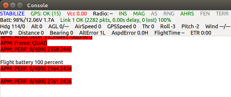
New Raspberry Pi 2 gives clear advantages over the older model, we are able to run main loop at 400Hz without missing a single cycle.  This is what your PERF will look like if you fly RPi2:

O96_fUfZBnyhpe9FZnu7VSU-GH6bYyBo4Ys4v6GbS__jxdHGR44jXR9SzfjWMZo2pSlQlFox6BouRMH_cJbAYre3zrAYYlvducZ1oSXdngcoGVpg40426egys9bGUTElrfugh2o?width=624

Today Emlid team celebrates its first birthday, a year ago we have started the Navio project with an idea to fly on Linux. I would like to thank everyone who worked with us through this year and made all this possible. Special thanks go to our team members who work hard, but do not usually show up as authors of blog posts: Georgii Staroselskii, Egor Fedorov and Vlad Zakharov.

You can get a Navio+ here :)

Have a great weekend!

Read more…
3D Robotics

Every time Festo puts out a new video, my jaw ends up on the floor. Their robo-butterflies can now navigate with "indoor GPS", which I think means motion capture cameras. Also: check out that ant! (20x+ as big as a real ant, but still!)

From CNET:

festo1.jpgFesto

The family of animal robots created by German robotics company Festo is growing. As part of its Bionic Learning Network, the company has introduced two new robots: a swarm of ants that can operate cooperatively, and a butterfly robot that leverages the insect's lightness.

The ant robots -- called BionicANTS -- are not just inspired by the insect's physical body, but by its swarm intelligence.

"Like their natural role models, the BionicANTs work together under clear rules," Festo wrote. "They communicate with each other and coordinate both their actions and movements. Each ant makes its decisions autonomously, but in doing so is always subordinate to the common objective and thereby plays its part towards solving the task in hand."

Each 13.5-centimetre BionicANT is visually arresting, too: their components are laser-sintered and finished with visible conductor structures, with electrical circuits attached on the outside -- giving them the role of form as well as function.

A radio module on the ant's abdomen allows the robots to communicate with one another, and piezo-ceramic bending transducers are used in the actuators, allowing the legs and pincers to move with fast, precise accuracy. A 3D stereo camera in the ant's head allows it to see, and an infrared optical sensor on its underside records the distance it covers over the floor. Meanwhile, two on-board Li-Po batteries provide up to 40 minutes of wireless power, before requiring to be recharged in a dock via their feelers.

"The BionicANTs also come very close to their natural role model in terms of design and constructional layout. Even the mouth instrument used for gripping objects is replicated in very accurate detail," Festo said. "The pincer movement is provided by two piezo-ceramic bending transducers, which are built into the jaw as actuators. If a voltage is applied to the tiny plates, they deflect and pass on the direction of movement mechanically to the gripping jaws."

The delicate eMotionButterflies also use collective behaviour via an intelligent networking system.

"Flying is a recurring theme in the Bionic Learning Network," Festo said. "The developers channelled their knowledge gained from the projects on the BionicOpter and the eMotionSpheres into the bionic butterflies. They combine the ultralight construction of artificial insects with coordinated flying behaviour in a collective."

festo2.jpg

This system consists of ten high-speed infrared cameras installed in the space in which the butterflies fly. They track infrared markers on the robots, transferring this data in real-time back to a central master computer; this then coordinates the movements of the butterflies, preventing them from colliding with one another -- quite a feat, considering the 50-centimetre wingspan of the butterflies.

Yet each weighs just 32 grams, with 2 servo motors, the electronics and 2 small Li-Po batteries -- enough for just 4 minutes of flight, with a charging period of 15 minutes -- packed onto a tiny, laser-sintered body.

"With the butterflies themselves, Festo is taking another step into the areas of miniaturisation, lightweight construction and functional integration. The eMotionButterflies impress with an intelligently employed mechanical system and the smallest possible power units in the tightest space. The reduced use of materials enables the true-to-nature flying behaviour," Festo wrote.

Like all of Festo's robots, these are unlikely ever to see consumer production; rather, they're for the purposes of future industrial robot development. That doesn't mean we can't dream, though. You can read more about them on the Festo website.

Read more…
T3

3689643216?profile=original

GeoUAV is a specialized Workshop in the frame of the ISPRS Geospatial Week 2015. Dedicated to Unmanned Aerial Vehicles (UAV), it will bring the opportunity to research scientists and practitioners to share their experience in development and application of UAV for geospatial data acquisition.

3689643225?profile=original

The aim of the GeoUAV Workshop is to present advancements in the field of UAV geospatial data acquisition for civil usages. Themes and topics will include general purpose technological and data processing developments as well as application domains such as agriculture, environment, civil engineering, archeology, etc.

Call for Abstracts

Deadline for the submission of abstracts for oral or poster presentations is 15 April 2015. Authors will be informed of acceptance by 1st June 2015. Submission details and guidelines for authors can be found in the Abstract Submission section.

Topics

Submissions are invited in, but not limited to, the following areas:

  • General purpose developments
  • Flight programming and navigation
  • Active and passive sensors
  • Data georeferencing
  • Ortho mosaicking
  • Digital Surface modelling
  • Radiometric calibration and correction
  • Data processing

Others...

  • Applications
  • Agriculture
  • Environment
  • Civil Engineering
  • Architecture & Archeology
  • Water and coast survey
  • Unusual applications...

Looking forward to seeing you at GeoUAV 2015!

Thorsten

Read more…

3689642921?profile=originalHi, let me introduce my latest plan, a 300-sized FPV quadrocopter. My goal was to design a small 3D printed quadrocopter that can be printed on any cheaper DIY 3D printer. Additionally I wanted to simplify wiring and maintenance. So I decided to make a modular design. The hard-cased battery is fixed by small clips and can be replaced really fast. The front and rear arms are also modular, only 4 screws have to be removed before get out the arms. So for example, a complete pre-wired and assembled arm can be taken out to field as a replacement part. After a crash, can be replaced.

I tried to design the frame as closed as it can be, with maximum strength. As I said, all parts can be printed by a simple and cheap DIY printer too (the only requirement is at least 250 mm long table on printer), without support material!!! (I printed some test parts using a Makerbot, now the first complete prototype is under printing.). All parts will take around 250 ccm modell material, so will weight around 260 g in total of ABS.

3689642949?profile=originalHere are the most important dimensions:

3689642733?profile=original

Here are some cool features. First, the modular design:

3689642974?profile=original

Hard-cased battery (up to 114 x 38 x 24,2 mm battery size):

3689643009?profile=original

Custom PCB for RCTimer ESCs:

3689642871?profile=original

2 types of different Mobius vibration dampened mounts, can be adjusted in two positions (up by 10 degrees or level):

3689642892?profile=original3689643103?profile=original

3689643022?profile=original3689643063?profile=original

Any 1806 sized motors can be used (like DYS 1806), with props up to 6":

3689643111?profile=originalI designed a vibration dampened flight controller mounting too, for 30x30 hole positions:

3689643132?profile=original

Separated space for VTX, to help heat dissipation:

3689643044?profile=originalThese parts are required for building:

  • 2 pair of green Multiplex connectors (6-pin)
  • 1 pair of XT60 connector (and additionally as much as much battery case needed)
  • 8 to 22 mm long DIN 7981 2,2 DIA plastic screws (or similar type)
  • 8 pcs of small blue HK dampene

Additional parts list:

  • FLight controller with 30x30 hole spacing (for example VR micro brain?! :) )
  • Power distribution board with 30x30 hole positions (I suggest the HK one, with built-in BEC and V-I measurements)
  • 4 pcs of ESC (I suggest RCTimer Argonaut 20A, my custom PDB is designed for them)
  • 4 pcs of props, up to 6"
  • small RC receiver
  • Mobius HD (or similar sized HD camera)
  • Video TX (I'll use DAL 600)
  • some M3 plastic screws, spacers, nuts
  • mini Telemetry module (optional)
  • mini OSD (optional)
  • GPS receiver with 30x30 hole spacing (optional)

I suppose the AUW will be around 650 g which is, I think, quite acceptable for this size.

Since I spent many-many hours on design and parts testing, I can't share STL files for free, I hope everybody undestands my position. I even have to collect money on additional electronics for my prototype too (I'll post pictures once I finnished printing, assembly)...
So finally I decided to sell the complete STL package for 39 USD. Payment can be done by Paypal, email me for details (nhadrian@gmail.com)! The other reason is that I never get any donation related my work...

*** CAUTION - 1***
Please note that this is a prototype project not a final market product.
I'll not take care of any damages caused by faulty assembly or inproper printing result.
I'll not guarantee successful printing, since it depends on printer setup, used technology, etc...

*** CAUTION - 2***
Please note that I made the design regarding my current needs. I won't modify any of them for further requests (ie. other type of camera, FC, etc.) unless you pay my efforts, since I'm doing this in my limited spare time. 

***CAUTION - 3***
And, as always, use it on your own risk!!!

Thanks for understanding...!

I hope you like my design, Best Regards

Nhadrian

PS.: special thanks to Sys-ak for his support in this project!

Read more…

Win a Percepto - App Idea Competition

3689642854?profile=original

We would like to thank all our backers and to everyone who shared, posted and tweeted about our campaign! Because of your strong support, we've reached our goal!

We are officially one step closer to realizing our dream of community-powered computer vision drone innovation.


Marking the event, we are launching a friendly competition to find the most anticipated Percepto application.

How does it work?

  • You submit your idea for an app that utilizes Percepto

  • We will sort through your ideas and choose our 10 favorite apps, then open up the polls for you to vote for your favorites

  • The app that gets the most user votes wins a Percepto kit to be used for building the winning app

  • The app that the Percepto team likes best will also win a Percepto kit

  • Both winners will receive support and hands-on advice from the Percepto development team

3689642716?profile=original

Schedule

Enroll:           March 27th until March 31st

Poles open:  April 1st until April 2nd


The goal of this promotion is to increase the exposure and awareness of Pecrcepto, and while we would like to see the winner build a complete app using Percepto, we understand that such a task is not simple and that the winner may not be able to complete the build on their own. That being the case, the winner should attempt to develop the app using Percepto, however if they are unable to finish they will keep the percepto and share the process.

LInk to the contest page.


Read more…