All Posts (11086)

Sort by

Trent@MyGeekShow is alive!

Trent has just posted an update video explaining his recent absence from the online scene, identifying the fact that his shop is now back online and hinting at things come from MyGeekShow over the coming weeks.

Clearly he has been through the ringer these last few months, but appears to have returned fully charged (pun intended), and raring to get back into it.

Notably, Trent has acknowledged the additional challenges presented to his USA Trip by ongoing developments relating to the use of RC Model Aircraft in the United States.

The idea that the reinterpretation or reformation of long established guidelines and policies might stifle the aspiration of pioneering individuals like Trent is pretty disheartening. There are indeed ways of circumventing the chaos, as we have recently seen with the coming out of Google's Project Wing, but this type of solution is sadly beyond the budget of individuals and backyard innovators like Trent. Hopefully sanity will prevail and that, when the uncertainty in this critical area of policy ends, the defining moment of his (so far) 4 year long project will not be relegated to the shelf of impossible dreams.

Read more…
3D Robotics

This new Kickstarter project looks awesome. I've backed it, and will experiment with it for autonomous blimps (as well as copters):

Simple and accurate target tracking hardware for Drones & DIY Robotics. Works in bright sunlight and even complete darkness.

IR Target Tracking for Everybody!

The custom-manufactured IR-LOCK filter enables simple and accurate target tracking for Drones and other DIY robotics projects. Positions of IR LEDs are accurately reported at 50Hz, with a detection range of over 50 ft when using high-power LEDs. The product platform is based on the user-friendly Pixy vision sensor (link), running IR-LOCK's specialized firmware. 

IR-LOCK & Your Project

The Pixy vision sensor is Arduino-compatible for your complex target-tracking projects. If you want to keep things simple, you can control pan/tilt setups by directly connecting to two servos. The developed IR-LOCK firmware reports the location of all IR targets (for microcontroller setups), or tracks the largest IR target (for pan/tilt setups).

How it Works

The custom-manufactured IR-LOCK filter blocks visible light, while allowing particular wavelengths of infrared light to pass through. 940nm IR LEDs are easily detected by the Pixy vision sensor. Since these LEDs are widely used in DIY and consumer products, the development cost for an IR target can be as low as $1 for an LED and coin battery, or long-range markers can be created using high-power LEDs.

Max Tracking Range

The tracking range of the IR-LOCK filtered Pixy can be increased in various ways: (1) multiple LEDs can be clustered together to increase the size of the infrared target, (2) a lens with a narrower field of view will increase detection range (link), and (3) high-power LEDs can be used for long-range, outdoor applications.  

Custom IR Target Creation

What IR-LOCK target will you create? Here are some ideas to help get you started. If you want to hit the ground running, get our 360° tracking pod and simply plug it into a lipo battery. 

Rewards

Take advantage of the Early Bird discounts while they last. Thanks for your support!

If you don't have a Pixy, check out one of these two kits (below). They include an IR-LOCK filtered Pixy w/ specialized firmware.

If you already own a Pixy, check out these modification kits (below).

Technology Capabilities & Limitations

The key benefit of using IR LEDs as targets is that the performance is not dependent on ambient lighting conditions (e.g., shade, dim lighting, bright sunlight, etc.). Actually, IR-LOCK target tracking works great in complete darkness.

IR-LOCK is continuously working on solutions to minimize 'false detections', while maintaining sensor range and sensitivity. Unfortunately, sunlight and lightbulbs also emit infrared light. The IR-LOCK filter blocks most of this light, but some of it will inevitably pass through to the Pixy sensor. Thus, 'false detections' may occur if the Pixy is (a) pointed directly at a light bulb, or (b) bright sunlight is reflected from a contoured, shiny object (i.e., 'glare'). 

interference from 72W lampinterference from 72W lamp
reduce chance of 'false detections' by changing brightness settingreduce chance of 'false detections' by changing brightness setting

Tech Specs

Development Team

Thomas Stone is leading the IR-LOCK development effort, along with the invaluable support of colleagues, friends, family, and Pixy (Charmed Labs). Thomas is a research assistant in the Robust Product Creation Lab (RPC) at Georgia Tech. He previouslyworked in consumer product development both for startup companies and large companies such as Coca-cola, Craftsman, and Jarden.

Development Timeline

All rewards are scheduled to ship by December 2014 (and the sooner, the better!)

Read more…
3D Robotics

Disney patents copter-controlled puppets

3689613960?profile=originalFrom IEEE Spectrum:

Disney has a research lab in Zurich, right next door to ETH Zurich. In the past, we've seen a lot of collaborations between Disney and ETH, often in the form of fun robot concepts and prototypes. So, we weren't at all surprised to hear that Disney filed a patent for an "Aerial Display System With Marionettes Articulated and Supported by Airborne Devices," because we spotted a prototype at ETH Zurich last year, and its name is Maurice.

PuppetCopter Maurice was a Focus Project at ETH Zurich last year. Focus Projects "allow engineering students at ETH Zurich to apply their theoretical knowledge in practice. During two semesters they independently develop a product. Based on an innovative project idea, the teams pass through this reality all processes of product development." And it sounds like this particular project was actually commissioned by Disney:

Walt Disney is always looking for new attraction for amusement parks. The task, they asked a team of budding engineers and industrial designers was to create a flying doll that attracts viewers. The doll is Maurice and may Waving, Walking, Flying and light up in different colors. This is made possible by a Hexacopter with a balanced platform on which are the action arms for controlling the doll. The doll itself is made entirely in the rapid prototyping process.

There's a video of Maurice in action on its Facebook page, here.

Disney's patent isn't for Maurice specifically; it's for a much more generalized (and much, much larger) PuppetCopter system that can handle absolutely monstrous puppets:

See all those strings? Imagine an autonomous quadcopter attached to each one, making Jack dance. Dance, Jack. DANCE!

The aerial display systems described provide a number of useful advantages over prior display techniques and devices. For example, large characters can be flown safely to make a dramatic display. The characters Or marionettes can be articulated much more freely and effectively than, for example, a dirigible. The marionette's body may be formed of very light materials yet can be made to appear to be relatively hard or firm (e.g., hard-appearing edges and features) while remaining soft and flexible, which improves safety for an audience of spectators below the flying marionette. The use of a lightweight marionette allows a team or number of relatively small UAVs to provide the relatively small suspension force required to keep the marionette afloat with or without articulation. The marionettes described are not tethered to the ground or are not ground based but, instead, are supported by flying vehicles that provides a unique and dynamic aerial show. 

Disney set down two other UAV-related patents, including one for UAVs that hold up moving projection screens, and other for UAVs that form aerial displays out of floating pixels. That last one is basically the Disney ResearchPixelbots gone airborne, but we have to point out that people have been thinking about this for a long time (MIT's Flyfire is from 2010) and actually doing it for slightly less of a long time.

I think Disney's clever idea to call them "flixels" is cool, though, and if they can pull together enough flixels to form an actual flying display, that would be seriously impressive, since even a basic flying display with a QQVGA resolution (160x120) would need 19,200 (!) individual flying robots. Which would be awesome. But good luck.

[ PuppetCopter Maurice ] and [ Patent ] and [ Manuel Ailinger ]

Via [ MarketWatch ]

Read more…
3D Robotics

Robo-birds to scare away real ones

From Wired:

Birds are nice enough, unless you work at places like airports, farms, and landfills, in which case they’re the sworn enemy. Today, there are a variety of tools and technologies for spooking unwanted birds—we’ve graduated from scarecrows to flash-bang grenades and other sophisticated armaments—but Nico Nijenhuis is undoubtedly working on the coolest. He’s building robot hawks that trick lingering critters into thinking they’re about to get snacked on.

Nijenhuis, a 27-year-old based in the Netherlands, is the mind behind Robirds, a line of robotic birds of prey. He’s hoping to sell them to the aviation and waste management industries under the name Clear Flight Solutions. (Company tagline: “We create birds.” Fair enough!) Nijenhuis is currently testing remote controlled Peregrine Falcons and eagles with promising results. By the end of the year, he’s hoping to have fully autonomous robot birds on offer.

The endeavor got its start a few years back when Nijenhuis was a student of applied physics and fluid dynamics at the Technical University of Twente in the Netherlands. He was trying to figure out what to do for his Masters thesis and asked his adviser if there was an experimental project he might work on. The adviser grabbed a crude prototype of a mechanical bird off a shelf, handed it to Nijenhuis, and said, “Figure out how this works, and how to make it better.”

The Difficult Problem of Flapping-Wing Flight

Creating machines that mimic birds might seem like a straightforward proposition, but it’s not, in large part because we still aren’t totally sure how birds work. “From a scientific point of view, we don’t truly understand flapping-wing flight,” Nijenhuis says. When wings are fixed, we’re fine. We can run tests and calculate forces and as a result have been able to develop planes that take us all over the globe. “But the minute wings start moving, we really have a problem,” Nijenhuis says. “It’s all about very complex, three-dimensional flow. What a bird actually does is so complex that it’s incredibly difficult to mimic.”

With his Robirds, Nijenhuis had to figure out which parts of flapping-wing flight he could actually simulate. The big concept ended up being flexibility. Instead of just flapping from one joint like a rigid two-by-four, bird wings deform across their entire length as they move through the air.

For the Robirds, Nijenhuis complemented the basic hinging motion with a pitching motion on the wing tips–the further outward you go, the more the heavy-duty foam wings deform upwards and downwards. The result, when paired with some on-board sensors and sophisticated stabilization software, is a fairly convincing approximation of bird flight.

Getting close to the mark is important for the Robirds to do their job. Nijenhuis says two things are needed to trigger birds’ flight instinct: a silhouette and wing movement. “If it doesn’t look like a predator, they don’t care. And if it doesn’t move like a predator, they don’t care either.”

ONE LANDFILL HAS SEEN A 75 PERCENT DECREASE IN BIRD VISITS. THE ONES THAT DO RETURN HAVE THEIR HEADS ON A SWIVEL.

As far as the look goes, the Robirds rely on a 3D printed body, which comes right out of the machine with full falcon colors, modeled after photographs taken by the Clear Flight team themselves. The body is made of a glass-fiber nylon composite, which is both lightweight and rugged. “You can crash these things into the ground at 50 km/h and almost nothing will break,” Nijenhuis says.

That’s important too. In the early going, crashes were very much part of the process. The current version of the Robirds are remote controlled, and you have to be a fairly experienced RC aircraft pilot to fly them. The falcon model can fly up to 50 mph. But Nijenhuis and his team—currently a group of three Masters students and two researchers in robotics and mechatronics—are currently working on an autopilot system which they hope to finish by the end of the year. Robird handlers would be able to define a preset area in which the birds could fly, or draw out a pre-programmed flight path on a tablet app, hurl the thing into the air, and the birds would do the rest.

The Robirds are currently being trialed in the Netherlands. At one landfill, they’ve seen a 75 percent decrease in bird visits. The ones that do return have their heads on a swivel. They know there are predators about–which gets to the big selling point of Robirds. While flash bangs might scare birds, they’re only short term measures. The birds often end up coming back. With Robirds, Nijenhuis says, “there’s a natural reason for the birds to stay away.”

Read more…

So the hunt continues, seems that the Universe heard my need for a demonstration video. It does the trick. 

As I get deeper into how to accomplish all the parts needed for this new flight mode idea I have focused on the controls, rather feeling the need to see what may be available when it rounds completion rather than what is available now. Quickly realized some flaws in the idea as when I began to use my own head to try and just steer something, it seems intuitive or that it would be, but its not, well at least not for me. Especially when trying to hold my head in strange angles... Wow, if I want to climb holding your head still is kinda hard, there is going to need to be allot of tuning here, mostly figuring out range that is comfortable.

Starting to think using the muscles themselves over the position is the ticket. Sensing the intended change rather than final position is the answer (maybe). The head tracker that I am using in the tests so far is very prone to misorientation and maybe a collar device will be better. Looks like the MyoWave setup will have a use there also... Now to start mocking that up...

Read more…
Developer

APM Planner 2.0.15-rc1 (Beta Release)

3689613791?profile=original

APM Planner 2.0.15-rc1 release is available.

When we released 2.0.14, we added a feature to subscribe to beta releases (we've called them 'release candidates' i.e. rc releases)

If you would like to help us test these new releases before we declare them stable (which would be awesome!) You can select Beta Release option checkbox in the APM Planner 2.0 Config setting view (See above graphic)

Please discuss issues or feature requests in the ardupilot forum for APM Planner 2.0 

Download of pre-built binaries are available here

Have good weekend!

Read more…
Developer

Lidar landing with APM:Plane

Over the last couple of days I have been testing the Lidar based auto-landing code that will be in the upcoming 3.1.1 release of APM:Plane. I'm delighted to say that it has gone very well!

Testing has been done on two planes - one is a Meridian sports plane with a OS46 Nitro motor. That is a tricycle undercarriage, so has very easy ground steering. The tests today were with the larger VQ Porter 2.7m tail-dragger with a DLE-35 petrol motor. That has a lot of equipment on board for the CanberraUAV OBC entry, so it weighs 14kg at takeoff making it a much more difficult plane to land well.

The Lidar is a SF/02 from LightWare, a really nice laser rangefinder that works nicely with Pixhawk. It has a 40m range, which is great for landing, allowing the plane plenty of time to lock onto the glide slope in the landing approach.

APM:Plane has supported these Lidars and other rangefinders for a while, but until now has not been able to use them for landing. Instead they were just being logged to the microSD card, but not actively used. After some very useful discussions with Paul Riseborough we now have the Lidar properly integrated into the landing code.

The test flights today were an auto-takeoff (with automatic ground steering), a quick auto-circuit then an automatic landing. The first landing went long as I'd forgotten to drop THR_MIN down to zero (I normally have it at 20% to ensure the engine stays at a reasonable level during auto flight). After fixing that we got a series of good auto flights.

The flight was flown with a 4 second flare time, which is probably a bit long as it allowed the plane to lose too much speed on the final part of the flare. That is why it bounces a bit as it starts losing height. I'll try with a bit shorter flare time tomorrow.

Here is the video of one of the Meridian flights yesterday. Sorry for missing part of the flight, the video was shot with a cell phone by a friend at the field.

Here is another video of the Porter flying today, but taken from the north of the runway

I'd like to thank Charles Wannop from Flying Finish Productions for the video of the Porter today with help from Darrell Burkey.

Read more…

Hobbyking seems "Serious" now

3689613754?profile=original

Hobbyking just came with new large multirotor brushless motors.

 9235-100kv , that spins 30" props on 12S and capable of lifing 11kg each.

And for sure , these are cheap again, 1/3 of Tiger motor 10kg level, U11 motors.

http://www.hobbyking.com/hobbyking/store/__54888__9235_100KV_Turnigy_Multistar_Brushless_Multi_Rotor_Motor.html

Hobbyking selling needed props too..

3689613687?profile=original

http://www.hobbyking.com/hobbyking/store/__54889__30x8_0_MultiStar_High_Efficiency_Carbon_Light_Core_Multirotor_Propeller_CW_CCW_for_9235_Motor.html

Read more…

Sony to begin developing drones from Biz / Tech Aug. 27, 2014 - Updated 23:26 UTC-4

3689613713?profile=original

http://www3.nhk.or.jp/nhkworld/english/news/20140828_20.html


Officials of Sony say they have begun developing unmanned aerial vehicles commonly known as drones. Sony holds the leading global market share for sensors that work like human eyes. They are used in digital cameras and other devices. Sony wants to expand the use of the technology to drones....


Look promising

Read more…

Payloader max prototype complete

3689613601?profile=original

So, the first payloader max is built - time for testing!

Just got the APM to put back onto the lifter, and away we go.

Payloader max: 5kg capacity via parrallel EPM's, no moving parts to fail, full autonomous integration with arducopter 3.2.

The foldable lifter (around 11-12kg lift, depending on how you mark the efficiency loss of X8):

3689613640?profile=original

3689613332?profile=original

Read more…
T3

Ground/Air Drone Delivery

image-gallery-01._V367570019_.jpg%22

With all this talk about Amazon and other less serious drone delivery concepts out there, there has been a large amount of discussion regarding the feasibility of delivering a package via drone for same day delivery or general delivery. While I don't think this is really all that feasible from a logistical or safety point of view, the idea is interesting.

What would be more realistic in my mind is a better system where you have autonomous ground vehicles carrying packages and UAV's. The autonomous ground vehicles being developed by various companies like Google's self driving cars are getting better and closer to integration into society, although I'm sure the regulatory hurdles will be just as painful.

The basic concept is you have that autonomous ground vehicle, probably just like a UPS truck outfitted with sensors, carry packages around the city to delivery locations much like is currently done using people. Simple enough but that alone wouldn't get the package to your door as I know I wouldn't want a van driving through my lawn up to my door to "fling" a package at my house or door. Instead, the autonomous UPS/FedEx/whatever truck dispatches a mutlirotor of appropriate size with your package to go from truck to door. Ground navigation is hard enough on the road but getting around a cluttered yard or sidewalk is going to be really hard. With a quad/hex/octo, you could easily have it take off, fly over all the obstacles, drop the package off near the door, and head back to the truck to essentially charge itself back up.

A delivery truck is going to be large enough to carry all the sensors it needs for autonomous navigation as well as packages and delivery "drones". As seen just a couple of days ago, Tridge and the team have also demonstrated a milestone in getting ArduPlane running and flying an airplane using Linux and ArduCopter likely is close behind. With that comes all sorts of possibilities like running SLAM or other computer vision algorithms, which would aid in a multi dropping a package off at your door.

If you want to get around the FAA regulations too, tether each multi to the truck! Then it's considered a tethered object and no different than a kite! You'll need a way to keep the tether from getting to the blades but there are enough people out there like Jack Crossfire that could whip something like that up and take care of that issue. It's one way to get things rolling without waiting for the FAA to get their act together.

With Amazon's announcement of drone delivery, much of the speculation has focused and assumed a drone is going to go from a warehouse to your door, which rightfully so, with just one or two images and a video of an octo, that's what people are going to think. However practicality suggests that's really unrealistic. It's going to take something more than just some quads to implement a system like this but I get the feeling it's going to be a combination of autonomous UGV's with UAV's that will get the job done.

Read more…

FAA BVLOS Committee Formed

3689512329?profile=original

The FAA has formed a new committee with industry participation for end-users that want to fly Beyond-Visual-line-Of-Sight (BVLOS). RCAPA was included in the list of thirty-one different industry groups to give input to the current FAA UAS ARC about “immediate, near and long-term issues/hurdles are or might be for fielding this technology.”

RCAPA President, Rick Connolly accepted on behalf of the membership.

“We designated “Patrick Egan to represent the RCAPA membership due to his experience and passion in the Global Airspace Integration experience including his prior participation on the sUAS ARC. While committee participation is not exactly the seat on the UAS ARC that we have petitioned for, it will allow us some level of participation to voice the concerns of the membership… mainly certification issue. We strive to be a unified voice for the small business UAS industry.”

While we were reminded that this isn’t a seat on the UAS ARC, the board is hopeful that the powers that be are receptive to the notion of common sense regulations prevail and that small business might have some valuable insights to contribute.

RCAPA Board member, Gene Robinson also had comments about the RCAPA’s committee participation.

“…… RCAPA has been contributing to the unmanned aircraft community since 2005 to provide as much-practical experience possible in the decision-making process for flight in the NAS. With the information that is taken from actual field use of UA, we have been able to divine what the best operating practices are, acceptable environments to fly in, and the safest possible combination of aerial tools to use. As the technology rapidly changes, we will tirelessly continue to gather and apply the best hardware and continually redefine concepts that have been proven in the past.”

You can discuss the RCAPA’s inclusion on the BVLOS committee and other timely subjects at the RCAPA Facebook page.

Be sure to join the RCAPA as the numbers help to support the technology and your future

www.rcapa.net

RCAPA400_Working%20FilePlat.psd

Read more…

Official UN Policy Brief on Humanitarian UAVs

ICARUS Quadcopter

Cross-posted from iRevolution

The United Nations Office for the Coordination of Humanitarian Affairs (OCHA) just published a pivotal policy document (PDF) on the use of civilian UAVs in humanitarian settings. Key excerpts from this 20-page & must-read publication are highlighted below.

  • UAVs are increasingly performing civilian tasks as the technology becomes more common. In fact, 57 countries and 270 companies were manufacturing UAVs in 2013.
  • Humanitarian organizations have started to use UAVs, including in Haiti and the Philippines, for data collection and information tasks that include real time information and situation monitoring, public information and advocacy, search and rescue, and mapping.
  • Use of UAVs raises serious practical & ethical issues that humanitarian organizations must address through transparency, community engagement, and guidelines for privacy & data security.
  • To tap into the growing interest in UAVs, particularly in technical communities, humanitarian organizations should engage in networks that promote good practices and guidance, and that can serve as a source of surge capacity. [Like the Humanitarian UAV Network].
  • Due to their affordability, ease of transport, and regulatory concerns UAVs used in humanitarian response are likely to be small or micro-UAVs of up to a few kilograms, while larger systems will remain the province of military and civil defense actors.
  • Interest is building in the use of UAVs to assist in search and rescue, particularly when equipped with infrared, or other specialty cameras. For example, the European Union is funding ICARUS, a research project to develop unmanned search and rescue tools to assist human teams. [Picture above is of UAV used by ICARUS].
  • The analysis of data from these devices ranges from straight-forward to quite technically complex. Analytical support from crowdsourcing platforms, such as Humanitarian Open Street Map’s Tasking Server or QCRI’s MicroMappers, can speed up analysis of technical data, including building damage or population estimates.
  • More research is needed on integrating aerial observation and data collection into needs and damage assessments, search and rescue, and other humanitarian functions.
  • The biggest challenges to expanding the use of UAVs are legal and regulatory. [...]. Most countries where humanitarians are working do not yet have legal frameworks, meaning that use of UAVs will probably need to be cleared on an ad hoc basis with local authorities. A particular issue is interference with traditional air traffic [...].
  • Any use of UAVs by humanitarian actors [...] requires clear policies on what information they will share or make public, how long they will store it and how they will secure it. [...]. For humanitarians operating UAVs, transparency and engagement will likely be critical for success. Ideally, communities or local authorities would be informed of the timing of flights, the purpose of the mission and the type of data being collected, with the aim of having some kind of informed consent, whether formal or informal.
  • Although UAVs are getting safer, due to parachutes, collision avoidance systems and fail-safe mechanisms, humanitarians must think seriously about liability insurance and its cost implications, particularly for mechanical failure. Due in part to these safety concerns, ultra-light UAVs, such as those under a kilogram, will tend to be more lightly regulated and therefore easier to import & operate.
  • More non-profit or volunteer groups are also emerging, such as the Humanitarian UAV Network, a global volunteer network of operators working for safe operations & standards for humanitarian uses of UAVs.
  • The pressure for humanitarians to adopt this technology [UAVs], or to provide principled justifications for why they do not, will only increase. [...]. Until UAVs are much more established in general civilian use, the risks of humanitarians using UAVs in conflict settings are greater than the benefits. The focus therefore should be developing best practices and guidelines for their use in natural disasters, slow-onset emergencies and early recovery.
Screen Shot 2014-06-24 at 2.22.05 PM

In conclusion, the UN brief offers several policy considerations:

  • Focus on using UAVs in natural disasters and avoid use in conflicts.
  • Develop a supportive legal and regulatory framework.
  • Prioritize transparency and community engagement.
  • Ensure principled partnerships.
  • Strengthen the evidence base.
  • Update response mechanisms [...] to incorporate potential use of UAVs and to support pilot projects.
  • Support networks and communities of practice. [...]. Humanitarian organizations should engage in initiatives like the Humanitarian UAV Network, that aim to develop and promote good practices and guidance and that can serve as advisors and provide surge capacity.

The Humanitarian UAV Network (UAViators) is actively engaged in pursuing these (and other) action items. The Network promotes the safe and responsible use of UAVs in non-conflict settings and is engaged in policy conversations vis-a-vis ethical, legal & regulatory frameworks for the use of UAVs in humanitarian settings.  The Network is also bringing UAV experts together with seasoned humanitarian professionals to explore how best to update formal response mechanisms. In addition, UAViators emphasizes the importance of community participation. Finally, the Network carries out research to build a more rigorous evidence based so as to better document the opportunities and challenges of using UAVs in humanitarian settings.


See Also:

  • Humanitarians in the Sky: Using UAVs for Disaster Response [link]
  • Live Crisis Map of UAV Videos for Disaster Response [link]
  • Humanitarian UAV Missions During Balkan Floods [link]
  • UAVs, Community Mapping & Disaster Risk Reduction in Haiti [link]
  • “TripAdvisor” for International UAV/Drone Travel [link]
  • How UAVs are Making a Difference in Disaster Response [link]
  • Humanitarians Using UAVs for Post Disaster Recovery [link]
  • Grassroots UAVs for Disaster Response [link]

Read more…

Should We Let the Drone Hype Run Its Course?

3689613540?profile=originalThe mere mention of “Autonomous Vehicles” conjures up visions of machines able to carry out complex tasks that have taken us a millennium to evolve or tasks we have yet to take on ourselves.  With national discussion (in this case, Unmanned Aerial Systems – UAS) focused on UAS policies, applications, and capabilities leading us to dream about the future of UAS systems, take a moment to consider how UAS development charts against the Gartner Hype Cycle because my concern is that FAA policies developed during the early periods of innovation (and hype!)  could stifle long term productivity of the industry.
Drones are one of those areas that stimulate the imagination, like rocket ships and X-Ray Specs in the 1950s and with good reason.   The first is the open source environment of many of the technical components of UAS systems that enable developers and innovators to get under the hood and customize the flight characteristics and autonomous function of the flight control systems.  These pioneers, standing on the shoulders of earlier pioneers, inspiring the next generation of pioneers, ensure a constant stream of advanced concepts hovering across the UAS landscape, in discussion groups, and in public dialogue, creating excitement and worry.  While some concepts have merit (obstacle avoidance, location reporting, product delivery), many are unsound (persistent surveillance) without a technical breakthrough or fail the common-sense test (beer delivery!) as we already have laws that apply to a specific use.

The second is that you can turn practically anything into a drone with the availability of parts and the sharing of ideas.  You can literally make a brick “fly” like a robot.  In addition to the aerial kind, I’ve seen drone boats, cars, kites, jellyfish…even a robot fish that helps direct schools of fish, all bringing their own use-case scenarios that run the spectrum from brilliant to nefarious applications.

To make any of the drone hype a reality, you have to match a great design with all of the Size, Weight and Power (SWaP) limitations.  Most often these requirements provide enough challenges to slow the rapid expansion and application of drone technologies without the need for all-encompassing policy or regulation.  The realization of these requirements tip us over the crest of the Hype Cycle Expectation Peak and downward into the Trough of Disillusionment as businesses manage expectations and match market demands with reliable components and the right amount of progress.

The reality is that people will always hype what drones can do, what we want them to do, how they will impact our lives and most of these will never take to the air because the laws of physics AND the law of Supply and Demand get the final vote.  I am one of these people who dreams of UASs that can find lost hikers, that can carry a WiFi signal or a vaccine and I’ve had the ground come up and smite my systems enough times that I now carefully weigh the benefits before I hit the throttle.

This is where FAA policies, rules, and governing regulations need to be applied; after the flood of ideas and big dreams have been grounded in reality.  Setting policies to encapsulate all the bad ideas currently out for discussion will ultimately crush industry and innovation of the good ideas.   Afterall, television is still a great idea despite 13 seasons of Big Brother.

I know we WANT the FAA to get its policies in order and allow the commercial development to proceed as rapidly as we come up with a great new use-case, but we need to let the technology follow its course a little longer to where we can see the productivity-potential (as we stand there picking up the pieces of our systems that couldn’t live up to our grand ideas) and focus policies where they allow the right kinds of innovation and encompass the safety/rights of the general public.

Read more…

Community Drones : A Short (unprofessionally made) Clip

Dear all: Thanks lot for all the insights, time, information and most importantly is the spirit that you all share here in DIY Drones. It is just a quick post as I am still in Borneo and not having too good internet connection. We just want to share a short (unprofessionally made) clip that we (hardly) tried to make. I hope it will give you all some information on how far (or how slow) we are now in trying to keep the work going.

Enjoy,

Best,

Rai

Read more…
3D Robotics
3689613512?profile=originalFrom Mitchell Sipus, an urban planner doing doctoral research at Carnegie Mellon (scroll down for more good design examples of displaying drone legal and safety zones):
Just prior to my last stint of working in Somalia, I purchased a small consumer drone to use as social research tool.  Unfortunately the landscape had changed drastically since my last time in Mogadishu, and it was impossible to use, in particular because I am terrible at flying the damn thing. But I have since invested many hours into piloting the UAV to explore its utility as a research tool for urban planning and design.

Last weekend, a small disaster took place when I lost the signal to the UAV. The drone drifted out of sight and crash landed.  I had no idea where. It took several hours to find (on a building rooftop, I couldn't see it, but I found its WIFI signal), and even longer to recover (24 hours). At some point on Twitter, Constantine Samaras, raised a significant point: Perhaps this situation could have been avoided if I was in a no drone zone. But what does would that look like?

Legal Framework for Drones

In the United States, airspace above 700 feet is Federally restricted.  Airspace below 30 feet is considered part of individual property rights, meaning that when you own a piece of land, you also own the 30 feet of air above it. Ownership of this airspace is occasionally able to be sold for provide through a transfer of development rights. But what about the airspace between 30 and 700 feet?  At present, the FAA has restricted the use of drones for commercial use but amateurs are free to fly.

Some cities have already taken progressive steps concerning the legality of drones. The city of Evanston Illinois has passed a 2 year ban on drone use in the city for use in warrantless surveillance. This is a good thing. Carrol county in Maryland is looking for similar legislation on the use of drones by law enforcement. There was even recently a temporary event ban during golf tournament in North Carolina.  But existing UAV zoning laws are "all or nothing" in design, they do not make use of the opportunity that drones can provide in creating new markets, improved public policy, and better design for communities.

Zoning for Drones
In general, I'm not a big fan of city zoning.  I admire its intention, to make sure that the overall quality of urban life is consistent with high standards of physical and mental health.  We do not want the aluminum factory next to the children's playground or the speedway motor park in the residential neighborhood.  We do need a legal instrument for communities to make decisions about what they want to look like and how they need to function.  Yet overall, I find my city zoning is poorly conceived.  I am highly supportive of health standards, environmental regulation and taxes, but I see zero advantage toward regulating the values of a population (such as zoning concerning bars or adult services) or the economic geography as such zoning only reinforces the values of those who hold power, not the people who constitute the community.  Likewise zoning for residential vs. commercial use tends to put more strain on the landscape, increase traffic, increase pollution, and reduce the distribution of wealth. Zoning should not hinder social mobility, yet it can and does.

Therefore, to approach zoning for drones, it is important to examine the issue from multiple points of view.  After all, the goal is to create a regulatory framework that will maximize the ratio of nuisance to utility in favor of people at large, not a particular social group or economic class.

Areas of Review:

Example UAV Questions to Consider
Is the UAV big or small? 
Loud or quiet? 
Does it have a payload or a camera? 
Is it operating according to a predefined flightpath (using GPS waypoints) or is it freely piloted?
How fast and how high is it?
Is it for commercial or amateur purposes?

Example Site Questions to Consider
Is the site of high or low pedestrian traffic?
Does the site contain socially vulnerable or critical security infrastructure (schools, power plants etc)?
Does the site consist mostly of public or privately owned property?
To what extent is the airspace already cluttered and at what density?
Is this an area of high or low diversity in land use?

Example Population Issues
Is this area a public space or private space?
Is what is the privacy expectation in this space - for example, on a beach?

To recognize the array of drone designs and use designs is to realize that an affective zoning solution is flexible to support the advantages of the UAV but with limited interference upon bystanders. Conversely, it is important to insure that UAV operation is not disruptive to the general activities of the population.  Ideally, UAV operation should be able to operate "in the background" of day-to-day life.


General Guidelines for UAV/Drone Land Use Zoning Laws
While thinking about zoning for drones, one of the first questions that comes to my mind is "what will that look like"?  After all, 2-dimensional arial map is insufficient to capture the particular sense of space that will be used and affected by a UAV.  An advantage of contemporary design and modeling is that we do not need to restrict zoning maps to a 2D surface, but can draw these maps in the air, to model them above cities and within them.  A zoning map for drones should not only take advantage of modeling the airspace, but should take into consideration the variations of time.  For example, an area that might restrict private drone use from 9-5 could lift the ban from 30-400 feet after 5pm and 400-600 feet after 10 pm.

Implementation
It might seem abstract to place an imaginary 3D geometry around a building to restrict flight patterns. But for those who are already flying drones, it is no unimaginable.  Furthermore, providing the information online (such as a downloadable CAD file) for a drone operator to layer onto Google Earth or other GIS software would easily remedy the situation.  GPS and time sequencing can even be programmed into flight patterns.  It might seem abstract and hightech, but 3D mapping of airspace for drone use has few hurdles and requires no new technology.


CASE STUDY/CONCEPT EXPLORATION - CHICAGO
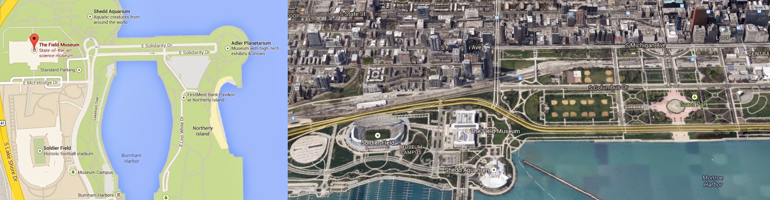
CHICAGO_MAP_SIPUS.jpg
Drone Zoning and Urban Planning Concept Location, Chicago Illinois. Sutika Sipus 2014.
Chicago_Drone_Zoning_backup.jpg
Drone Zoning Concept in Chicago, Illinois. Sutika Sipus 2014.


Case Study: Urban Planning for UAVs in Chicago

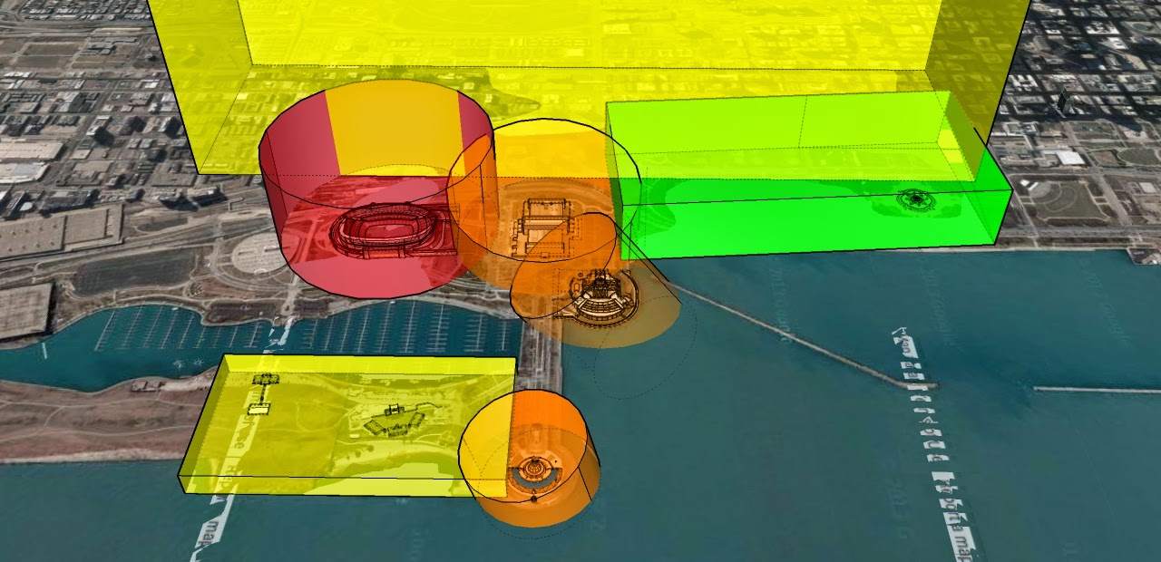
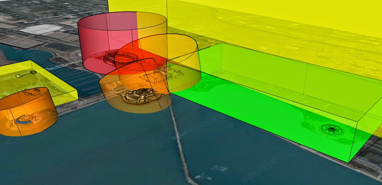
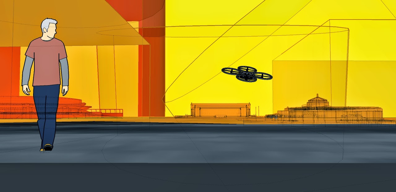
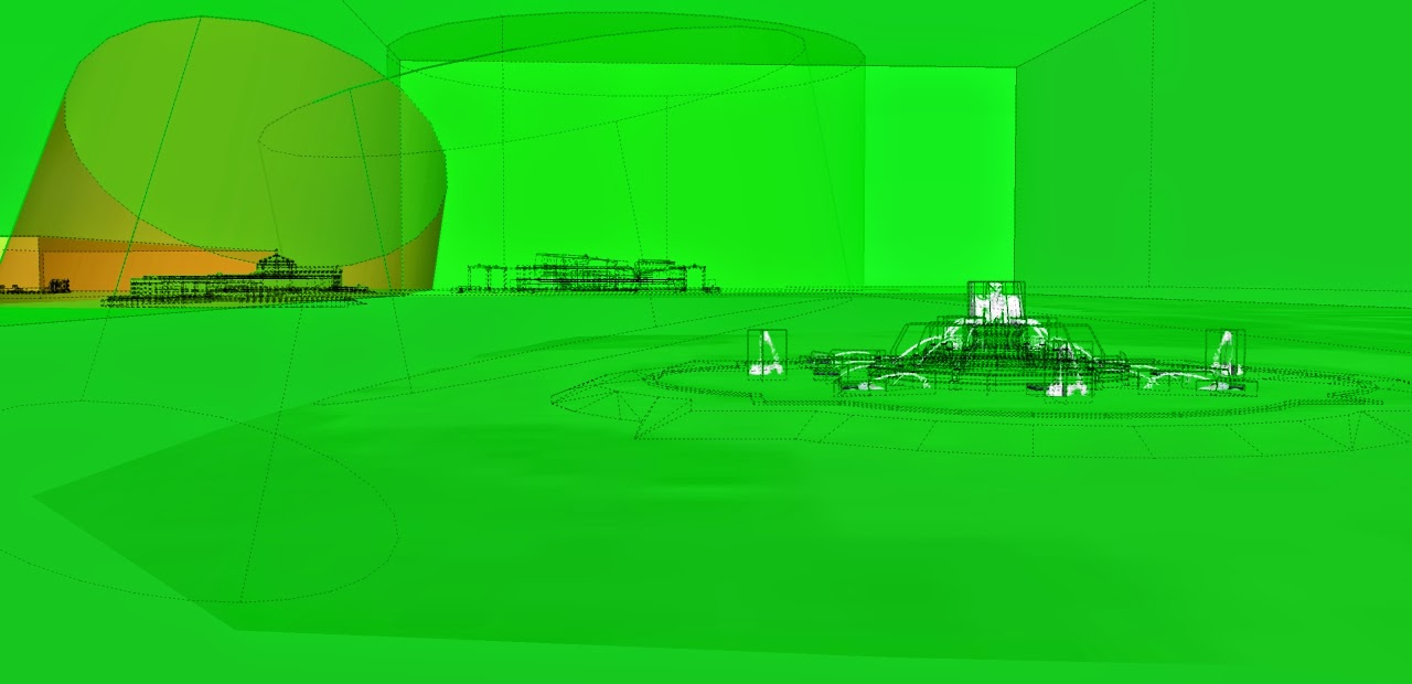
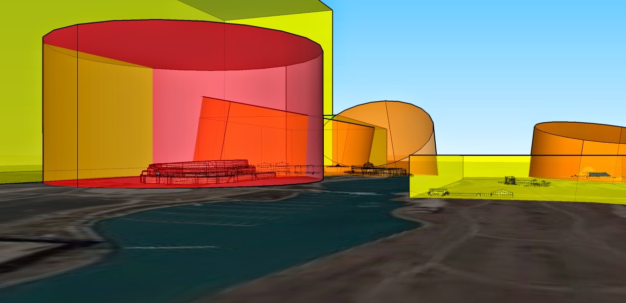
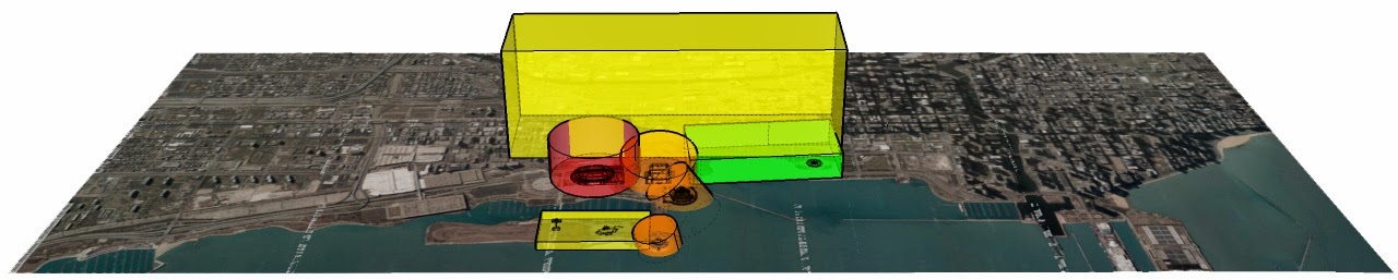
To explore this idea, I have rendered a rough concept drawing of drone zoning in the parks bordering downtown Chicago.  Basing the idea off of a traditional traffic light, green areas are free-use, yellow and orange maintain various restrictions according to the time of day and day of week, while red areas are restricted at all times.

Chicago_Drone_Zoning_BuckinghamFountain.jpg
Buckingham Fountain, Chicago, Open UAV Zone. Sutika Sipus 2014.
Open Droning
The green zone is near Buckingham fountain.  This area is a wide open space, with zero infrastructure of critical value.  It should be realized that we design areas where free drone use is available so as to offset the general distribution of restrictions.  A greenspace, therefore, should permit the widest amount of flexibility and opportunity.  Likewise, in such spaces we want to reduce the likelihood of losing the drone or disrupting others in the event of an accident.  Accidents will happen, so it is best to permit a space for those accidents to happen with limited consequence.
Chicago_Drone_Zoning_sideview.jpg
Side-View, Zoning for Drones/UAVs in Chicago. Sutika Sipus 2014.
Limited and Restricted Drone Use
In the image above the football stadium has been recognized as a "zero public drone" area.  In this space we can imagine private licensing options for droned cameras and advertising initiatives by the stadium and partners.  However, unaffiliated individuals should not have the right to use their drone in this are.
The yellow and orange spaces represent the Field Museum, the Shedd Aquarium, Aviary, and Observatory.  For the sake of the example, I have suggested that these properties contain their own particular rules that change according to the day, season, or event.  This is not a unreasonable regulation, given that it is common place to create zoning in a similar manner for public parking during weekdays, sporting events, and even according to the weather.
Chicago_Drone_Zoning_broadview_white.jpg
Example Drone Zoning in Chicago. Sutika Sipus 2014.
Chicago_Drone_Zoning_green_open.jpg
Alternative Perspective of Drone Zoning in Chicago. Sutika Sipus 2014.
Chicago_Drone_Zoning_up.jpg
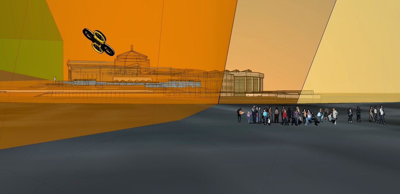
Drone Zoning at Human Scale. Sutika Sipus 2014
Chicago_Drone_Zoning_humanscale2.jpg
Drone Zoning at Human Scale II. Sutika Sipus 2014.
Read more…

Reno-2013-Sunday-9.15.13-Strega-Gold-Race-Second-Place-Pylon-2.jpgImage Credit: http://airpigz.com/Airpigs

Its that time of year Again! The time of year when grown men become antsy and giddy, as we did when we were young children during the holidays. Thats right, it is time to get in gear for Reno Air Races! As a long term spectator of the last remaining race of its nature, I am always excited to attend, this year more than ever! Why?....Keep reading....

Small-UAS-700x400.jpg

So at this point you might be asking yourself, what does this have to do with DIYDrones? Why is this posted on a primarily UAS networking and blog site? Well.... I just ran across this little gem. That's right, Reno Air races will be hosting a UAS demonstration and challenge. The challenge is open to everyone, from beginners, to starts ups, and onto the big boys in the industry. Rumor has it that the challenge will have everything from a weight lifting competition, obstacle course, and even a timed circuit. The demonstration will be held in a large netted enclosure connected to an existing hangar. What else? Well this event is approved, and supported by the FAA to try to raise awareness to not only the general public, but also the many private pilots in attendance. Not only that, but it is rumored that there will be numerous Unmanned aerial systems on display, once again everything from your start-ups to the giants in the industry. This is truly exciting considering Nevada's FAA established UAS test area. 

So, what is in it for you? First off, you get to fly in a challenge/demonstration, which would be totally fun. Secondly, you get 2 general admission tickets for the day you are participating. Last but not least, you get to attend the fastest race on earth. However, you do need to possess liability insurance, or insurance through the AMA to participate.

If you have not been to the Reno Air Races, it is a must for any flight enthusiast. There is nothing like seeing 3,600hp+ aircraft roaring past at speeds of up to 500 mph. The event contains aerial demonstrations, and all sorts of racing from the Formula one class (Aircraft slightly larger than your car, and smaller than some! Racing by with a mere 200 cubic inch engine), Sport class (consisting of homebuilt (primarily two seat) aircraft) and your Unlimited racers, which undergo extreme aerodynamic and engine modifications to squeeze out every ounce of speed. However now you can mix all this fun and excitement with your other favorite hobby, Flying UAS! 

Needless to say, I am very excited to see Unmanned Systems not only on display, but demonstrating their abilities at one of the most popular aerial shows around.

The UAS demonstration is put together in collaboration between David Thirtyacre at Embry-Riddle University, FAA, and RARA. For more information You can visit the Following:

http://airrace.org/national-championship-air-races-to-be-site-of-unmanned-aerial-challenge/

http://worldwide.erau.edu/newsroom/press-releases/worldwide-host-small-uas-challenge-september-national-championship-air-races-reno.html

http://news.erau.edu/top-news/worldwide-to-host-small-uas-challenge

I Hope to see you all there!

-Justin

PS, I have no connection to any of the aforementioned. I am simply excited and wanted to share it with you all!

Now for your viewing pleasure, Steve Hinton Jr takes you behind the stick in VooDoo for 491mph Qualifying session during last years event.

Read more…
3D Robotics

3689613456?profile=original

From Mashable. Watch the video here (it won't embed for some reason)

We saw drones firing missiles at Jeremy Renner in The Bourne Legacy, but in the spy game, those clunky old warbirds have got nothing on the stealthy eye-in-the-sky drones of The November Man.

Starring former 007 Pierce Brosnan, The November Man has modern hovering drones woven into the story: As the deadly ex-CIA agent stalks his mark, a drone is stalking him, allowing his team of handlers to coordinate his every move.

"The drones are always there, keeping track of everyone's movements and moving the story along," says the narrator in the above featurette that Relativity Media shared with Mashable.

And of course a spy agency would use drones to observe from the sky.

"A spy movie without that element wouldn't be up to date," director Roger Donaldson, who didn't just use the airborne cameras as story elements — he extensively used them to shoot it, too.

Donaldson liked the cameras so much that when drone pilot Justin Chapman and aerial photographer Chad King's two weeks of shooting were up, they were asked to stay — and wound up on set for nearly four months (they also got walk-on parts as CIA agents).

Read more…
Developer

APM:Rover 2.46 released

3689613398?profile=originalThe ardupilot development team is proud to announce the release of version 2.46 of APM:Rover. This is a major release with a lot of new features and bug fixes.

This release is based on a lot of development and testing that happened prior to the AVC competition where APM based vehicles performed very well.

Full changes list for this release:

  • added support for higher baudrates on telemetry ports, to make it easier to use high rate telemetry to companion boards. Rates of up to 1.5MBit are now supported to companion boards.
  • new Rangefinder code with support for a wider range of rangefinder types including a range of Lidars (thanks to Allyson Kreft)
  • added logging of power status on Pixhawk
  • added PIVOT_TURN_ANGLE parameter for pivot based turns on skid steering rovers
  • lots of improvements to the EKF support for Rover, thanks to Paul Riseborough and testing from Tom Coyle. Using the EKF can greatly improve navigation accuracy for fast rovers. Enable with AHRS_EKF_USE=1.
  • improved support for dual GPS on Pixhawk. Using a 2nd GPS can greatly improve performance when in an area with an obstructed view of the sky
  • support for up to 14 RC channels on Pihxawk
  • added BRAKING_PERCENT and BRAKING_SPEEDERR parameters for better breaking support when cornering
  • added support for FrSky telemetry via SERIAL2_PROTOCOL parameter (thanks to Matthias Badaire)
  • added support for Linux based autopilots, initially with the PXF BeagleBoneBlack cape and the Erle robotics board. Support for more boards is expected in future releases. Thanks to Victor, Sid and Anuj for their great work on the Linux port.
  • added StorageManager library, which expands available FRAM storage on Pixhawk to 16 kByte. This allows for 724 waypoints on Pixhawk.
  • improved reporting of magnetometer and barometer errors to the GCS
  • fixed a bug in automatic flow control detection for serial ports in Pixhawk
  • fixed use of FMU servo pins as digital inputs on Pixhawk
  • imported latest updates for VRBrain boards (thanks to Emile Castelnuovo and Luca Micheletti)
  • updates to the Piksi GPS support (thanks to Niels Joubert)
  • improved gyro estimate in DCM (thanks to Jon Challinger)
  • improved position projection in DCM in wind (thanks to Przemek Lekston)
  • several updates to AP_NavEKF for more robust handling of errors (thanks to Paul Riseborough)
  • lots of small code cleanups thanks to Daniel Frenzel
  • initial support for NavIO board from Mikhail Avkhimenia
  • fixed logging of RCOU for up to 12 channels (thanks to Emile Castelnuovo)
  • code cleanups from Silvia Nunezrivero
  • improved parameter download speed on radio links with no flow control


Many thanks to everyone who contributed to this release, especially Tom Coyle and Linus Penzlien for their excellent testing and feedback.

Happy driving!

Read more…