All Posts (11086)

Sort by
Moderator

CRESTED BUTTE, Colo. -- We still don't have hoverboards or flying cars, but in the glorious future we live in today, we do have flying robots that can bring us beer. Unfortunately for those in the United States, the Federal Aviation Administration won't yet allow drones for commercial use. That means that while it's OK to fly beers around to your buddies in your spare time, no paid or promotional delivery services are allowed just yet.

            beerdrone.png
            Beer drones ride again!Eric Mack/CNET

But that hasn't stopped brew titan Anheuser-Busch InBev from looking into how drones might be able to help keep the party going in the near future. The company brought some experimental prototypes to Whatever, USA -- a fictional town that Bud Light created in Colorado last weekend for the purposes of throwing a party for 1,000 contest winners and creating all kind of new promotional content -- where I got an in-person demonstration.

I spoke with Federico Treu and Roberto Navoni of an outfit based in California and Italy called XTrace about the Bud Light delivery system that they worked up for "Whatever." Essentially, it's a custom-built quadcopter that's a slave to a beacon that also functions as a very simple remote control. Push one button, and the drone comes to you; a different button and it returns to where it started. Push a third button and the drone will follow you at a safe distance.

The small, lightweight drone can only carry one bottle of beer at a time, but it's still an important proof of concept for lazy beer drinkers everywhere. The drone can easily function as a push-button bartender or a beer-caddy, following you down the street with refreshment just hovering a few feet away, just in case you need a drink (the fourth and last button on the remote tells the drone to land where it is).

"When we started this project, the idea was that, it's really difficult to fly drones," Treu told me outside the Crested Butte "Whatever" Visitors' Center. "But drones nowadays are smart enough to follow you, so even people that have never tried can fly a drone -- just hold the beacon, press the button and go."

For drone nerds, there are also some interesting things going on behind the scenes of what seems like a simple remote-controlled drone setup. For the prototypes in use at "Whatever," Navoni is in charge of safety. He walks around wearing Google Glass running a custom-made Glass app that provides him with a view of what the drone is seeing, as well as all the relevant statuses for the drones current operation.

In other words, while it may seem almost like a simple toy, Navoni is able to monitor everything that's happening with the drone through Glass and take over control of the drone if need be.

Treu says the next challenge for their drones is to automate obstacle avoidance. He says the drone in use at "Whatever" only has a carrying capacity of about 1 pound, but other form factors could easily handle bigger loads.

The drones came to "Whatever, USA" as part of a partnership through the "beer garage," a sort of skunkworks lab run out of San Francisco that looks at use digital tools and other innovations to promote brands like Bud Light.

Check out a delivery in action in the video below. The entire sequence was done by pressing only two buttons on the beacon.

CNET Article : http://www.cnet.com/news/beer-drones-are-back-this-time-with-google-glass/
Read more…

Outback Challenge 2014

3689615356?profile=originalIt's that time again!

With only 2 weeks until the UAV Outback Challenge (OBC) 2014, there is a record 20 teams from around the world ready to win the Challenge.

The OBC is a civilian UAV competition where teams must design, build and operate a UAV that is capable of finding a missing hiker and dropping a bottle of lifesaving water to them. It is held in Kingaroy (Australia) every second year and has attracted many hobbyist and university teams.

First prize is $50,000 and is yet to be claimed, giving an idea of the technical challenges involved in the OBC.

Many of the teams involved are using open source flight controllers (such as APM:Plane) and do contribute back to the community, furthering the hobbyist UAV movement.

The full list of entrants is:

  • Aeolus (Singapore)
  • Open UAS (Netherlands)
  • NCSU Aerial Robotics Club (USA)
  • Team Condor (Australia)
  • Monash UAS (Australia)
  • Perth UAV (Australia)
  • IRSA Group (Iran)
  • Compass UAV (Australia)
  • Swiss Fang (Switzerland)
  • MelAvio (Poland)
  • VAMUdeS (Canada)
  • SFWA (Australia)
  • TinBox UAV 2 (Australia)
  • Robota (USA)
  • Rescue Robotics (Australia)
  • Team Aetournos (France)
  • H2Joe (Australia)
  • MUROC Wild Hogs (Australia)
  • Canberra UAV (Australia)
  • Team Thunder (Australia)

As the manager of the CanberraUAV team (that were first place winners in the 2012 OBC), I'd like to offer the best of luck to all teams competing in the 2014 OBC, and we'll see you all in Kingaroy in 2 weeks!

Read more…

3689615236?profile=original

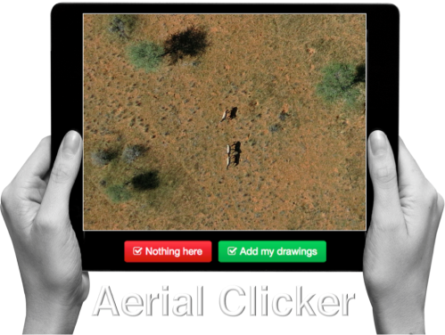
UAVs are increasingly used in humanitarian response. We have thus added a new Clicker to our MicroMappers collection. The purpose of the “Aerial Clicker” is to crowdsource the tagging of aerial imagery captured by UAVs in humanitarian settings. Trying out new technologies during major disasters can pose several challenges, however. So we're teaming up with Drone Adventures, Kuzikus Wildlife Reserve, Polytechnic of Namibia, and l’École Polytechnique Fédérale de Lausanne (EPFL) to try out our new Clicker using high-resolution aerial photographs of wild animals in Namibia.

As part of their wildlife protection efforts, rangers at Kuzikus want to know how many animals (and what kinds) are roaming about their wildlife reserve. So Kuzikus partnered with Drone Adventures and EPFL’s Cooperation and Development Center (CODEV) and the Laboratory of Geographic Information Systems (LASIG) to launch the SAVMAP project, which stands for "Near real-time ultrahigh-resolution imaging from unmanned aerial vehicles for sustainable land management and biodiversity conservation in semi-arid savanna under regional and global change." SAVMAP was co-funded by CODEV through LASIG. You can learn more about their UAV flights here.

Our partners are interested in experimenting with crowdsourcing to make sense of this aerial imagery and raise awareness about wildlife in Namibia. As colleagues at Kuzikus recently told us, “Rhino poaching continues to be a growing problem that threatens to extinguish some rhino species within a decade or two. Rhino monitoring is thus important for their protection. One problematic is to detect rhinos in large areas and/or dense bush areas. Using digital maps in combination with MicroMappers to trace aerial images of rhinos could greatly improve rhino monitoring efforts.” 

So our pilot project serves two goals: 1) Trying out the new Aerial Clicker for future humanitarian deployments; 2) Assessing whether crowdsourcing can be used to correctly identify wild animals.

MM Aerial Clicker

Can you spot the zebras in the aerial imagery above? If so, you’re already a digital ranger! No worries, you won’t need to know that those are actually zebras, you’ll simply outline any animals you find (using your mouse) and click on “Add my drawings.” Yes, it’s that easy : )

We’ll be running our Wildlife Challenge from September 26th-28th. To sign up for this digital expedition to Namibia, simply join the MicroMappers list-serve here. We’ll be sure to share the results of the Challenge with all volunteers who participate and with our partners in Namibia. We’ll also be creating a wildlife map based on the results so our friends know where the animals have been spotted (by you!).

MM_Rhino

Given that rhino poaching continues to be a growing problem in Namibia (and elsewhere), we will obviously not include the location of rhinos in our wildlife map. You'll still be able to look for and trace rhinos (like those above) as well as other animals like ostriches, oryxes & giraffes, for example. Hint: shadows often reveal the presence of wild animals!

MM_Giraffe

Drone Adventures hopes to carry out a second mission in Namibia early next year. So if we’re successful in finding all the animals this time around, then we’ll have the opportunity to support the Kuzikus Reserve again in their future protection efforts. Either way, we’ll be better prepared for the next humanitarian disaster thanks to this pilot. MicroMappers is developed by QCRI and is a joint project with the United Nations Office for the Coordination of Humanitarian Affairs (OCHA).

Any questions or suggestions? Feel free to email me at patrick@iRevolution.net or add them in the comments section below. Thank you!

Read more…

3689615178?profile=original

Hi, 

We have developed a suite of mobile and cloud / desktop applications on Android, iOS app and RPAS / sUAS / UAV / Drone Job Management website that integrates with your mobile devices called RPAS Logger (Remotely Piloted Aircraft System = RPAS ) to be used as a drone logbook. 

The apps include a bar code scanning feature for battery / maintenance management and our latest (most requested feature) allows you to use your GPS location on your mobile device to show you the nearest airport / helipad etc to your current location which will help in completing your Risk Assessment for each job or flight. www.rpaslogger.com 

RPAS Logger EnterpriseThis is the flagship version of RPAS Logger. Unlike the Lite and Pro version, RPAS Logger Enterprise is a cloud-based solution. All Data is kept in the web application and your mobile devices will now become access points that you will be able to use on and off line to collect and log data.


It is oriented towards a commercial operation. It will allow you to create jobs for customers, assign equipment and personnel to different jobs, manage area approvals and risk assessments, manage maintenance requirements and inventory.

Modules will include:
Basic Module – everything required to create jobs, manage airframes, batteries and role equipment usage, manage pilots (including type endorsements and certifications) and produce comprehensive reports.

  • Maintenance Module – Keep maintenance logs for all equipment and manage your inventory - including shelf life and minimum quantity reporting.
  • CRM – Integration into popular CRM modules, or use our vTiger based CRM. Integration for popular financials applications (like XERO)
  • UOC Manuals – online management of your flight, operations and maintenance manuals. Easily update your entire documentation suite with any changes that you make to your fleet, role equipment or operational parameters.

We will appreciate any feedback or request for new features. Rest assured, we have a long list of upcoming features but use your comments to help prioritise our updates. 

Read more…
Moderator

LiPO Fire Testing

In light of the recently ATSB report that identified an Australian Certified UAV Operator at the cause of a LiPO fire onboard an airline flight, I've decided to release some footage from our internal staff training video that shows what happens when LiPOs go up in smoke.  

In the video we set off some LiPOs by themselves, some LiPOs in two different types of LiPO safe bags.  Needless to say anything in the vicinity of the LiPOs will catch fire, so whilst the first test doesn't show flames, just imagine it inside your suitcase full of flammable materials.

What was surprising during one of the tests, one LiPO bag ended up catching fire!  The other LiPO bag contained the fire as it was designed to do.

Please don't try this at home kids, we had fire extinguishers at the ready and there were no combustible or flammable  materials in the vicinity.

Read more…

Mini hex + autotune = success.

Slapped together a factory-fresh mini hex with HK APM mini + 3DR ublox, balanced the props, fired it up in the air and ran autotune, in a breezy day. Over tuned with the factory settings, but flying ok now - just needs a tweak here and there.

This is the result. Needs  bit of D I think, to stablise it a bit. Maybe more aggressive control in pitch to stop the high frequency oscillations?

Will upload settings once I get home. 3.2rc7, factory fresh build.

Read more…

3689615158?profile=original

... this is how we would control our drones in the near future, if this promising object recognition technology from Google goes mainstream (and gets an API). I think drones and other mobile robots could benefit a lot. Check this out:

Automatic object recognition in images is currently tricky. Even if a computer has the help of smart algorithms and human assistants, it may not catch everything in a given scene. Google might change that soon, though; it just detailed a new detection system that can easily spot lots of objects in a scene, even if they're partly obscured. The key is a neural network that can rapidly refine the criteria it's looking for without requiring a lot of extra computing power. The result is a far deeper scanning system that can both identify more objects and make better guesses -- it can spot tons of items in a living room, including (according to Google's odd example) a flying cat. The technology is still young, but the internet giant sees its recognition breakthrough helping everything from image searches through to self-driving cars. Don't be surprised if it gets much easier to look for things online using only vaguest of terms.

3689615150?profile=original3689615212?profile=original

more to read:

source: http://www.engadget.com/2014/09/08/google-details-object-recognition-tech/?ncid=rss_truncated

source: http://googleresearch.blogspot.com/2014/09/building-deeper-understanding-of-images.html

Read more…

Dronehenge

Last week I was privileged enough to be invited to fly over Stonehenge Aotearoa, a modern day full scale adaptation of the original Stonehenge.

This was a great opportunity to test out the new Spline waypoint functionality that is coming in the next release.

The footage was captured on a 3DR X8 + GoPro.

It is a combination of manual flying for the close up shots and spline waypoints for the further out footage.


Stonehenge Aotearoa is a fully functional Astronomical Structure including a gigantic clock and calendar.  In addition to demonstrating the changing altitude of the midday sun over the year, it also identifies the current date, the times of the solstices and equinoxes and the precise time of local noon. It also reveals things that we cannot see - the ever changing length of a day (due to the eccentricity of the Earth’s orbit) and, where the sun would be seen if you could view it from space - the constellation it would appear to be moving through.  It also identifies the time of solar conjunctions with bright stars.

Unlike the original, visitors are able to take guided tours through the structure and see it working.


Read more…

PX34-A refit (update)

It may not look like much, but she's got it where it count. After much flying , realize that the original frame which is EPS foam didn't stand up well to the abuse of hard landings and later scrapped. This time replace it with EPP foam to give it the added durability it needs,

AUW 250g still the same light weight bird

last tested 2 flights total 10mins flight on a 3s 500mah and thats with the camera onboard. ,n not bad similar capacity of a small multirotor on the same payload. to my guess

after much flying , realize that the original frame which is EPS foam didn't stand up well to the abuse of hard landings and later scrapped. This time replace it with EPP foam to give it the added durability it needs,

AUW 250g still the same light weight bird

last tested 2 flights total 10mins flight on a 3s 500mah and thats with the camera onboard. ,n not bad similar capacity of a small multirotor on the same payload. to my guess

this was inspire from a friend who does his Aerial Photos the good old fashion way , with No FPV , Active Flight Controller or GPS.... guess alot to learn from the older guys out there this is Pure LOS flying

the challenge now is if this can the deliver the shots as good as the more sophisticated platforms out there.

any advice.?

Read more…

3689615090?profile=original

"The FAA has released a set of cease and desist letters sent in 2012 and 2013 to people operating drone vehicles for a variety of purposes including: tornado research, inspecting gas well stacks, aerial photography, journalism education, and other purposes. Drone cease and desist letters sent during 2014 are available from the FAA upon request." The text of the letters (bureaucratically polite, but bureaucratically firm) often starts with notes indicating that the UAV operators to whom they were sent that the FAA became interested in them because it "became aware of" their web sites, or even because someone tipped them off about an article in a community newsletter. The letters go on to outline the conditions under which the FAA allows the operation of unmanned aircraft, and specifically notes: Those who use UAS only for recreational enjoyment, operate in accordance with Advisory arcular 91-57. This generally applies to operations in remotely populated areas away from airports, persons and buildings, below 400 feet Above Ground Level, and within visual line of sight. On February 6, 2007 the FAA published UAS guidance in the Federal Register, 14 CPR Part 91 / Docket No. FAA-2006-25714 I Unmanned Airaaft Operations in the National Airspace System. Toward the end of the docket it says, ''The FAA recognizes that people and companies other than modelers might be flying UAS with the mistaken understanding that they are legally operating under the authority of AC 91-57. AC 91-57 only applies to modelers, and thus specifically excludes Its use by pecions or companies for business purposes."

From Slashdot.

Read more…
100KM

FLIR Tau 2 revisit

http://youtu.be/EZ4HON4k_qk

A few months ago I fly a mission with a Tau 2 640 infra red camera. All the info is here.  The first trial prove that the equipment can indeed operate in night condition and we learn how to take off and land in that condition. Unfortunately during the first few flight we did not capture clear video that show the existent of our target, the small size marque monkey. This is mainly due to the inconsistent radio collar signal we received ,so we may have plan the wrong flight path. 

This time, with a more organised planning, sufficient ground survey to confirm the movement of the two monkey that fitted with radio collar, we know where our target was and plan the flight accordingly. With the same set up and same flight altitude, this time we do successfully record them which show up as bright white spot in the video.

Flying at 100 meter, the monkey only show up as a few pixel through the camera sensor. So we are not hoping to see the animal outline through the video. As there are no bigger size animal stay on top of tree at that area, those white spots found around the tree area are pretty much confirm that is the marque monkey. More detail analysis will require to make accurate survey but we have demonstrate that it is viable with our low cost UAV.

I post this video for those who may be interest to use this camera for their research work as a video out put reference. 

Read more…
3D Robotics

How the Robot Dragonfly is tested

Back in 2012, I backed the Robot Dragonfly on Indiegogo. They've had trouble getting it out the door, because it's incredibly complex, but the silver lining is that they've been great about providing regular updates and insights in the project's development. Today's is particularly interesting, on how they test the feedback system. The video above tells the whole story.

3689615029?profile=original

Read more…
3D Robotics

3689614888?profile=originalFinally, I can talk about what I did this summer! Richard Branson, one of my heroes both as an entrepreneur and aviation pioneer, is a 3D Robotics investor. Not only is it thrilling to be part of his network, but we also got to bring a fleet of drones to his famed Caribbean island, Necker, to tell the story of his life there from an aerial view. This is just a teaser below, but you'll see much more soon: 

From Branson's own post on this:

We welcomed six drones to Necker and they’ve captured stunning footage of this beautiful island we call home.

Every morning before breakfast I go for a walk around Necker. I’m incredibly lucky to have had Necker in my life for nearly 40 years, and I feel I know it like the back of my hand. So it’s amazing to get views of this island that I’ve never seen before thanks to a few drones and the great team at 3D Robotics, a company I recently invested in. They even shot me playing tennis and kitesurfing to Moskito Island!

It’s amazing to see what a little flying object with a GoPro attached can do; before they came along the alternative was an expensive helicopter and crew. I’m really excited about the potential for drones, and I hope this affordable technology will give many more people the chance to see our beautiful planet from such a powerful perspective.

But it’s not just about beauty shots. When you say the word ‘drone’, most people will think about military drones, which are used for surveillance and warfare. But this increasingly affordable, easy to use technology is starting to be used around the world in many positive ways. Like to monitor endangered species, deliver healthcare to remote areas, and help manage natural disasters.

One of the drones exploring the Great House. Image from 3D Robotics

We’ll be sharing lots of stories about people and organisations involved in drones over on Virgin Unite from next week in our ‘Drones for good’ series. 

Meanwhile, where did my sunglasses go?

This film was shot on 3D Robotics IRIS and X8. Learn more at 3drobotics.com and via Twitter.

Read more…

beagle.jpgHello everyone, beaglepilot project has reached two most important milestones in the last couple of weeks. First one was first Arduplane flight by Andrew Tridgell: First Flight Plane and first Arducopter flight by Victor Mayoral Vilches: First Flight Quad. As Victor mentioned in his blog post that he was running Arducopter @ 100Hz and that we are working on enabling 400Hz. In this post I'll be sharing some figures which display performance of Arducopter running @ 400Hz and under three prominent conditions, the conditions are as follows:

1. no load: The code is executed without any stress i.e. no extra software is run besides background processes.

2. Very heavy load: The code is executed under very high stress environment: 2 CPU-bound processes, 1 I/O-bound process, and 1 memory allocator process. Under this environment CPU is running @ 100% and MEM is running @ greater than 50% overall.

3. Only CPU load: The code is  executed with load only over CPU (100%) using 7 CPU-bound processes.

Tool used for analysis is a tool named Stress which is a simple workload generator for POSIX systems.

Following is a chart of results obtained:

URpF6hW.jpgclick on the image to checkout full perf gists.

Description about kernels used:

Preempt-rt: this version of kernel is 3.8.13 with preempt-rt patch (about) and basic preemption enabled.

Vanilla: plain 3.8.13 kernel without any patch or extra configs.

Preempt: this version of kernel is plain 3.8.13 kernel with preemptible kernel option enabled.

You all are welcome to share your conclusions or critique on this data.

Thankyou.

Regards,

Siddharth Bharat Purohit

Read more…

APM:Plane advanced tree avoidance algorithm

3689614975?profile=originalAs we all know, UAVs, High Altitude Ballooning (HAB) payloads, kites and just about anything man-made that flies will be drawn inexorably towards trees by a dark and mysterious force which has so far defied scientific explanation.

As part of the Low Orbit Helium Assisted Navigator (LOHAN) project, Pixhawk brain surgeons Linus Penzlien and Andrew Tridgell have hewn an APM:Plane advanced arboreal avoidance algorithm from the living code, the better to keep our Vulture 2 spaceplane beyond the grasp of malevolent magnetic trees' limbs.

We can't yet reveal just how the sensational MAG_TREE_AVOID works its magic, but we offer you a bit of weekend fun in naming the parameter.

Tradition dictates that every LOHAN parameter must have a snappy acronym or backronym, so we're running a poll of Register readers' suggestions, to determine the matter.

Among the contenders are AYCARAMBA (Automated Yet Comprehensive Arboreal Recognition And Magnetic Branch Avoidance), LARCH (Lohan Arborial Repulsion Coded Heuristic) and SAMBA (Software Application for Magnetic Branch Avoidance), the last one of course being a tip of the hat to Tridge.

The author of the poll winner will receive some LOHAN stickers, which are currently available as a reward for our ongoing Kickstarter campaign to launch the Vulture 2 at Spaceport America, New Mexico.

3689614863?profile=originalWe're obliged to all those DIY Drones members who've already chipped in to support the cause, and if the rest of you have a few bucks spare, there are plenty of nice rewards on offer.

Read more…
Moderator

LiPO Fire onboard Fijian Airlines B737

3689614928?profile=originalThe Australian Transportation Safety Bureau published its report in relation to a cargo hold smoke event involving a Boeing 737.  http://www.atsb.gov.au/publications/investigation_reports/2014/aair/ao-2014-082.aspx

The smoke was detected by the airline Captain during the external inspection on the tarmac during preflights.  The source of the smoke was later identified as being some LiPO batteries for a UAV.  The passenger failed to declared the LiPOs when asked at check in.  The ATSB revealed that the passenger was an Australian certified UAV operator.

Australian civil aviation safety regulations permit LiPO batteries to be transported as CARRY ON as long as they are <100WH and are packaged to prevent short circuits.  http://www.casa.gov.au/wcmswr/_assets/main/dg/luggage/brochure.pdf

I frequently travel on aircraft with LiPO batteries, and before I travel all the terminals and balance leads are taped with electrical tape.  They are stored in LiPO safe bags, and then transported in a pelican case as carry on.

It makes sense to take every precaution because I'd rather not be on a plane that crashes because of a LiPO fire.

Read more…

3689614795?profile=original

Over the course of three days in August, I along with more than 670 participants at the Ohio UAS Conference 2014 in Dayton, OH, witnessed a large number of government and aerospace company attendees interested in taking drones into commercial markets.  From the dozens of presentations and interactions I had with academics, military contractors, aircraft manufacturers, parts suppliers and many others at the event, it’s clear that government and aerospace have jumped on the drones-for-commercial-use bandwagon.  But, for a number of reasons, this group’s aircraft aren’t going commercial just yet.

To be clear, the Ohio show was about showcasing proof of concepts and building partnerships – not flying and getting customers. This stands in stark contrast to the Precision Aerial Ag Show I attended earlier this summer, where many vendors demoed their aircraft and showcased their customers and established relationships with local service providers.

Why the dissimilarity?  Part of the difference is in approaches to FAA regulations.  The aerospace and military contractors play it safe by following all the FAA guidelines — regardless of which airspace they fly or test in.  But commercial vendors, whose aircraft and commercial applications are intended only in Class G uncontrolled airspace approach FAA guidelines as just that—guidelines. I wrote about these “radical opposites” in The Business of Drones: A Tale of Two Cities.

What I found interesting about the Ohio show is that it revealed evidence of a closing gap between commercial and public sector approaches to drones. I see a trend in which aerospace companies are beginning to adopt model aircraft and consumer technology. Let me explain by telling the story of three vendors I saw.

Read more here: http://droneanalyst.com/2014/09/04/lockheed-drones-meets-gopro-ohio-uas-conference/

Read more…
3D Robotics

3689614742?profile=originalI'm tempted to get one just to play with the sensors for possible drone use. From the announcement: "This unique 360° vision system uses complex mathematics, probability theory, geometry and trigonometry to map and navigate a room. So it knows where it is, where it’s been and where it’s yet to clean." I don't know exactly what this means, but I like the sound of it! 

3689614903?profile=originalFrom Core77: "Coupled with infrared sensors that detect obstacles, data is generated. Some 31 Dyson robotic software engineers spent north of 100,000 R&D hours figuring out how to turn that data into a mapping and navigation system, accurate to "within mm," that sets the machine on a minimal-overlap, lawnmower-like course."

3689614773?profile=original

Read more…