All Posts (11069)

Sort by

5415668701?profile=RESIZE_710x

SokilLink Software Suite is a complete solution for unmanned vehicle operation. It runs on both ground and on-board PCs and delivers most required features for modern drones. The software allows users to control their drones in manual mode, observe real time digital video from on-board cameras with telemetry displayed on top, control the cameras using exposed APIs.

The solution is extremely flexible thus it allows to customize each feature and easily add new ones. For example, a vehicle can carry more that one camera, making it more suitable for professional operations, when an operator should be able to see UAV flight direction and observable object at the same time.

It also comes with powerful logging and monitoring features which are very helpful for hardware development, performance monitoring and troubleshooting


Key features


  • One digital data link for all kinds of data (video, telemetry, control)
  • Digital video streaming
  • Hardware video coding acceleration for low latency streaming (100-160ms)
  • Bi-directional telemetry streaming
  • UAV/ UGV manual control using gamepad or other input device
  • Connecting Ground Control Station software on a separate laptop
  • Cameras control (start/stop recording, still shot)
  • Multiple cameras support
  • Multiple video streams support (limited by radio link throughput)
  • Mesh networks support (WIP)
  • Multiple vehicles operation support (in Mesh and WiFi AP mode) (WIP)


Typical diagram


5415505701?profile=RESIZE_710x


Video output application


While most of applications are background services, thus have no user interface, this one is responsible for video output and telemetry drawing. It uses hardware video acceleration so video feed is displayed with minimal latency

5415668701?profile=RESIZE_710x


Configurator application


This application is aimed for software configuration and recording/displaying (real-time) system logs, what is very helpful during end product development and integration

5415679489?profile=RESIZE_710x

Customization


Although the solution has support for all important features to build a modern drone, it is also highly customizable. Many other hardware (cameras, radio links, various payloads and even autopilots) may be supported on a request. Feel free to contact us if you need any kind of customization!


Learn more


You can find more on the solution page or by reaching us via e-mail contact@sokil.aero.

Read more…
FlytBase, Inc. announces the launch of a Preferred Partner Program designed exclusively for drone system integrators, solution providers and drone hardware OEMs. With the mission of helping enterprises automate and scale their drone operations, FlytNow has successfully matured into a commercial-grade solution for managing remote, autonomous drone flights in real-time.
Read more…
3D Robotics

Welcome to the new DIY Drones design!

5395035462?profile=RESIZE_400x

You may have noticed that DIY Drones looks a little different today. That's because we finally switched over to the Ning 3.0 hosting framework, which offers a bunch of advantages along with continuity with the exiting content, membership and basic flow. Although Ning 3.0 was introduced back in 2013, Ning has changed hands since then and the development was not really complete until last year. So we waited until everything was stable to make the change.

Here are some of the new features that you may notice:

  • Works great on mobile! Finally, a responsive design that works on any size screen, taking advantage of the full width and height on any device.
  • Social sharing is built in (Twitter, Facebook, LinkedIn)
  • Wider layout takes advantage of larger screens, more open design
  • A lot of behind-the-scenes tools to make managing and moderating the site eaiser
  • Overall, we've cleaned up the site and removed older unused features. 

All your content and membership information should be transfered intact, but please let me know if anything is missing.

There are probably still a few glitches that we'll clean up over the next few days, but overall this should carry us well into our second decade!

Known bugs/items that we're working on:

  • Content from the old groups is not showing up. While we sort this out, you can get access to them on the old site here.
  • We're removed some navigation elements from the old site to simplify this one. If you're really missing something, let me know
  • We're debating between full-screen width (more spread out, but can get really sloppy on very wide screens) or fixed 1080 width (what it currently is).

Here's a screenshot of the "before" (it's a lot narrower)

5433481877?profile=RESIZE_710x


Read more…

Open Source Drone Remote ID

5393313093?profile=RESIZE_710x


With the arrival of the new European regulations, certain equipments will become mandatory. This results in France by the need to equip drones with a Wifi module which sends the position of the drone through the air (like a transponder)

In order to allow as many people as possible to have access to this device, Pierre Kancir (ardupilot developper), supported by Airbot Systems , have produced software, enabling this device to be DIY manufactured at low cost.

All files are open source, under the GPL license. They contain the sources, the software part allowing to make the drone wifi beacon, a software allowing to make a drone detection system based on wifi frames, an example of code ready to be installed on a basic module sold on common commercial platforms for approx 35 Euros, and also 3D files to print a protection box by yourself. We hope it can helps others, regarding the regulation of their countries

The files are available for download on Pierre's Github: https://github.com/khancyr/ and also on  Airbot Systems website: https://www.airbot-systems.com/free-downloads/

Read more…

5384302089?profile=original


We’ve given this professional training to dozens of international and national disaster management organizations during the past half-decade. We’ve also run this training for both new and highly experienced drone pilots in dozens of countries around the world. The purpose of this training is to make you an effective and responsible team leader when deploying drones in disaster response. This training is also a great fit if you’re simply curious to learn more about the latest on the use of drones in humanitarian efforts. Participants who successfully complete this self-paced training will receive an official certificate signed by WeRobotics, Direct Relief, MIT and UPenn. 

In short, we've been running professional trainings on the use of drones for disaster response for as long as we've been leading humanitarian drone missions (since 2015). To learn more about the training and to read testimonials from previous participants, please visit this page.

Read more…

drone delivery solutionCommercial drones are now becoming a mainstream technology, with the 2020 pandemic serving as a showcase for how drones can save human lives.

Drones have been used for delivery long before Amazon announced its Prime Air service. Founded in 2011, Zipline, a US-based company focused on medical drone deliveries became the pioneer in long-distance drone delivery, with distribution centers in Rwanda and Ghana. With an exponential growth since then, Zipline now delivers 65% of blood samples in Rwanda, particularly because the country lacks suitable road connectivity.

Companies like Zipline are investing heavily not only in better drone hardware but also in remote operations software, so they can intelligently & centrally manage a large fleet of drones.

How Does Drone Delivery Work?

Drone delivery refers to the act of moving a package from point A to B using unmanned aerial vehicles (UAVs). Such UAVs are either autonomous or remotely controlled by human pilots.


The infrastructure that powers drone delivery operations requires seamless integration between reliable drone hardware and robust software that can enable EVLOS/BVLOS Operations. The components of such systems include:

Drone Hardware

Drones that are capable of carrying heavy payloads; for example:

drone for delivery solution

Links to above-mentioned drone specs:

Companies like Zipline, Wing, etc., have their own fleet of drones specifically designed and developed to suit their specific delivery needs.

Note:

  • The above specifications are as given on the DJI and Foxtech website.
  • FlytNow is compatible with all DJI, Ardupilot, and PX4 based drones and provides software modules for EVLOS/BVLOS operation over 4G/LTE, 5G, Long-range RF.

Drone Fleet Management Software

drone delivery app

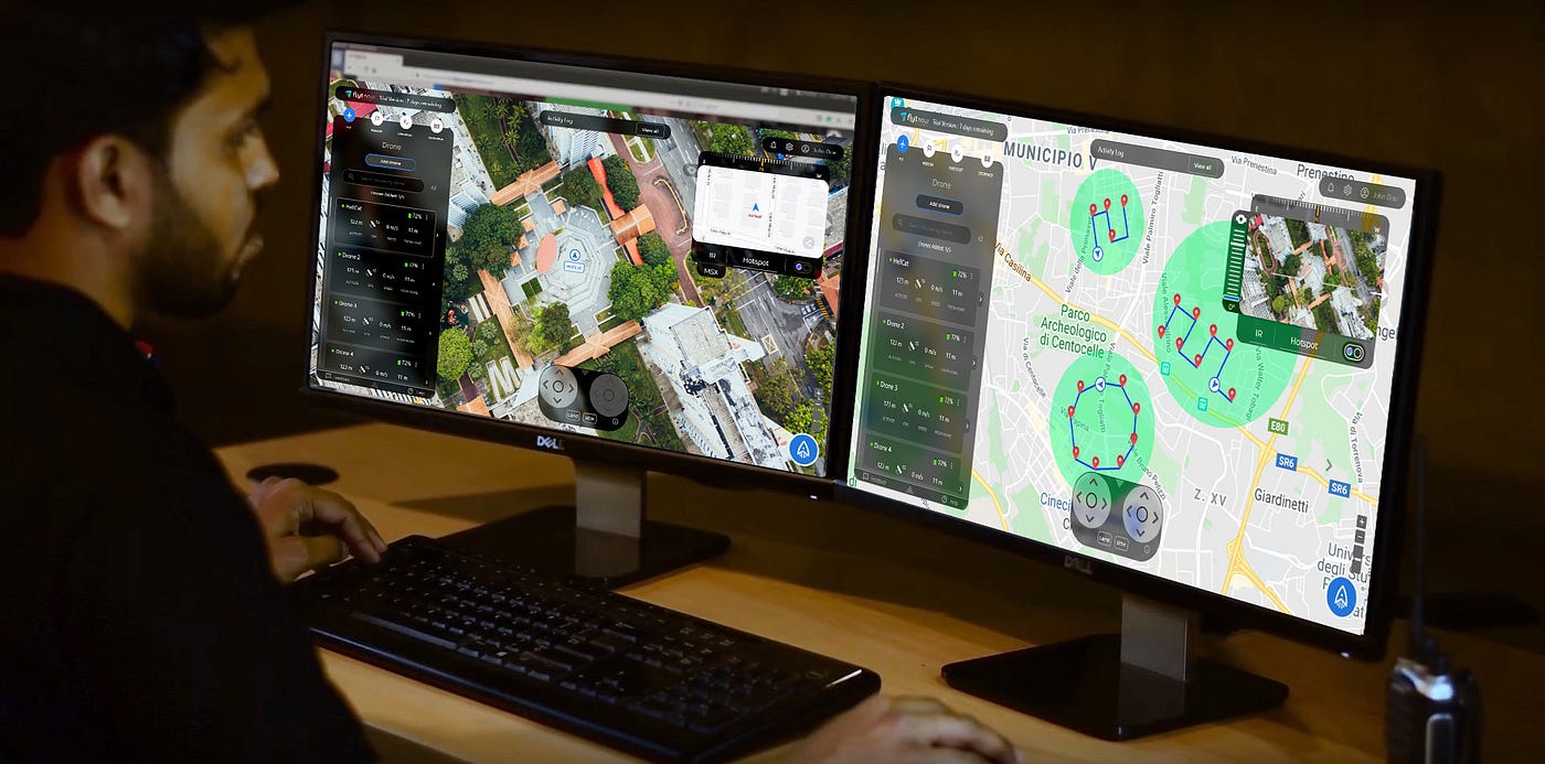
Drone delivery requires an advanced fleet management software like FlytNow that helps plan & execute long-range EVLOS/BVLOS flights with live tracking and drone control over 4G/LTE/5G.

FlytNow Delivery is a cloud-based offering that can be used for package delivery operations. Delivery businesses can use off-the-shelf or custom drones to quickly set up a delivery system in their geography. FlytNow solution cuts the deployment time to a few days and gives a unified web-based dashboard to control and manage every aspect of a drone delivery operation. FlytNow Delivery Offers:

  • Operator Dashboard - Centralized web-interface to manage all logistics operations
  • Dispatcher Dashboards - Web interface for store-fronts/medical centers to create delivery requests and live tracking.
  • Recipient Dashboard - Web and mobile interface to live track drone location and delivery status

Onboard Drone Software:

A drone equipped with intelligent onboard software make this kind of operation autonomous and safe. With the integration of FlytOS intelligent modules and sensors with onboard SBC (Nvidia Jetson Nano, DJI Manifold 2, Raspberry Pi 3B+/4), drones can do:

  • Autonomous Precision Landing or Hover (see FlytDock)
  • Collision Avoidance (see FlytCAS)
  • Electro-mechanical gripper control for package pick and drop
  • Electro-mechanical pulley control for releasing a package from a height.

Drone-in-a-Box (DiaB) Hardware:

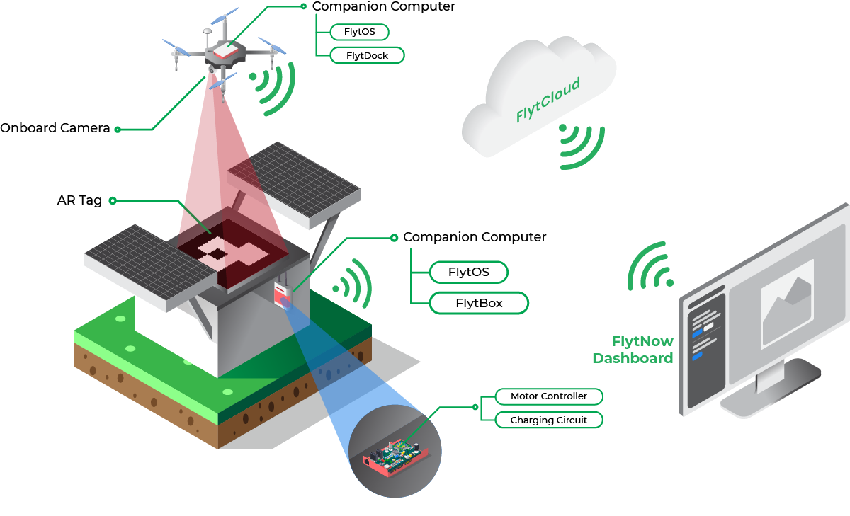
For operations to be autonomous and efficient -- physical, on-ground components such as a docking station, charging pad, launching systems, etc. are required. With FlytNow DiaB integration enables remote control & telemetry in the same delivery interface. Our enterprise solution also offers integration with DiaB APIs. Below are a few DiaB and charging pad solutions for reference:

UTM Integration:

Airspace intelligence and management is a critical enabler for scalable, safe, beyond-visual-line-of-sight (BVLOS) or extended-visual-line-of-sight (EVLOS) enterprise drone programs. Such integration with a UTM engine or national airspace services can augment sense-and-avoid capabilities with regards to airspace, flying advisories, and weather information for optimal path planning while avoiding no-fly zones and manned aircraft. Some leading UTM and providers are:

  • Airmap
  • Attitude Angel
  • Unifly
  • Airpalette
  • DigitalSky (for India)

Learn about the FlytBase partnership with AirMap here

FlytNow can be integrated with any 3rd party private or government UTM API services.

Advanced Fail-safes:

Whether you are flying in rural or suburban areas, the safety of people on the ground and expensive drone equipment is of utmost importance. Emergency situations like flight system failure, bad weather conditions, or immediate advisory from the local aviation authorities may happen anytime.

In addition to standard drone fail-safes (RTH, Geofence, etc.), FlytNow provides Emergency Landing Point (ELP) Failsafes. ELP Failsafes allow you to define landing points along your delivery route and land the drone on the nearest ELP when a situation arises.

FlytNow also provides advanced geofence features to draw a polygon on a map along the delivery route to restrict drones from going outside the designated area.

In unavoidable situations, a safety parachute on the drone can avoid accidents. Here are some of the brands which offer drone safety parachutes:

  • Indemis
  • ParaZero
  • VectorSave

Use FlytNow to Quickly Demo Your Drone Delivery Operation

FlytNow Pro is a cloud-based SaaS solution, well suited to help drone operators and service providers quickly set up a PoC (proof-of-concept) delivery system to validate a proposed delivery plan or to manage customer demos.

If you are someone who is looking to quickly validate a delivery idea then FlytNow Pro is a good starting point. As more requirements get identified, customers can then migrate to FlytNow Enterprise for Drone Delivery, which offers an end-to-end software suite with advanced capabilities and priority support.

Getting Started with FlytNow Pro for Drone Delivery PoC

Step 1: Sign up for a 28 days free FlytNow Pro account.

First signup to our free 28 days trial by visiting: https://my.flytbase.com/accounts/signup/?next=https://app.flytnow.com

Open your email and verify it before you can access the dashboard. Login to your account using your credentials.

On the dashboard, you can add drones, create a flight mission, set up a pre-flight checklist, and define a geofence.

drone delivery operations

In the above screenshot, We have already added our drones and two of them are online. In your case, you have to add the drones. Follow our getting started guide to add your DJI drones.

Do not have a drone? Try FlytNow Pro with Virtual Drone. Follow Step 2

(Optional) Step 2: Adding a virtual drone.

Your free trial account supports up to five drones. In case you don’t have a drone, you can also add a virtual drone, you can add one virtual drone. For a virtual drone, you need to set up your FlytBase cloud APIs. Please follow this guide.

drone delivery software

Once granted access to the cloud, you can use your virtual drone’s vehicle ID and token to add it to the FlytNow dashboard.

Step 3: Creating a Mission Plan.

A mission plan lets you add a route for your drone. Considering you are testing a medical delivery system, you use the mission plan to define routes to all the medical centers you want to make deliveries.

To add a mission plan, click on Mission -> Add Mission. Give a name to your mission and click on Add Waypoints to begin defining your route. Clicking on the map will place a pin; this way you can place multiple pins.

drone delivery software solution

In the above screenshot, we have defined a mission that tells a drone how to go to Palo Alto Health Care. Apart from defining a route, you can set the flight speed and a Finish Action. The Finish Action tells a drone what to do once it reaches the destination; you can set the following actions.

  • Hover
  • Land
  • Return to Home

In our case, we have selected Return to Home that signifies that the drone will drop the payload and return to base.

Please note that FlytNow Pro offers limited features for mission planning. Advanced features are available in FlytNow Enterprise for Delivery.

Step 4: Creating a pre-flight checklist.

This feature allows you to create a pre-flight checklist. In the case of a delivery operation, a checklist will ensure that a drone is configured properly before it is sent out on a mission.

To create a checklist, click on CHECKLIST and then Add to Checklist to add a checklist item. While adding a checklist item, you can also add a description.

delivery drone software

software solution for drone delivery operations

We have created a checklist suited for drone delivery operations. You can create your own checklist.

Step 5: Setting up a geofence

A geofence allows you to set up a boundary for your operations. Once you set a boundary, FlytNow will not allow your drones to fly beyond the boundary.

You can set up a geofence by:

  • Going to the GEOFENCE section in the FlytNow dashboard where you should be able to see your drones as a list.
  • Click on the edit option available in front of your drone name.
  • Enable the Geofence radius by clicking on the button.
  • Set the Geofence Values as per your safety requirements, i.e Height, and Radius.
  • The Height is restricted to 500 meters and radius is restricted to 8000 meters.
  • Click on the Save button after entering the values.

The following image shows you how your dashboard will look after geofence is set successfully.

A geofence has two circles. The area between the circles is called a warning zone. Whenever a drone crosses the first circle, the system gives out a warning, but it will not let the drone go beyond the second circle.

While planning a mission, you can’t put a waypoint beyond the first circle.

Step 6: Turn on Live video feed (feature works with a real drone only).

You can access the video feed of a drone from the dashboard. This feature is useful when a drone is out for delivery. This way you can visually assess a flight mission.

Select a drone under the FLY tab. Now you can see the video feed on the top right corner.

You can also enable the multi-cam mode (refer to the above picture) that will allow you to view the video feed from all drones on a single screen.

multi camera for delivery

Step 7: Share live drone location and video feed with a third party (feature works with a real drone only).

You can share live drone locations and video streams with anyone outside the FlytNow platform. This feature is useful especially when you want to share tracking information with a recipient which might include live video feed from the drone.

To initiate sharing click on the share button on the video panel

In the next dialog box click on Create new link.

Enter the email address of the person to whom you want to share the video.

Select the drones and your preferred options. You get the option to share both the map and the video.

The person with whom you have shared the live feed gets an email with a secure PIN. Tell him/her to click on View Operation and enter the secure PIN to start the live streaming.

Initiating a Drone Delivery

Once you are done with the basic setup, it is time to launch your first delivery mission. Consider a situation where you have received a delivery request from a nearby medical center, and you are about to initiate a launch.

Step 1: Launching a drone and selecting a mission.

Under the FLY tab select a drone (has to be online) and click on the launch icon in the bottom right corner.

You will be asked to select a flight mode. Select Mission. In the next window, you will see all your missions. Select a mission and click on start.

Step 2: Completing the pre-flight checklist and executing the mission.

Next, you have to complete the pre-flight checklist.

Once you are done with the checklist, hit Execute to begin your delivery.

What’s the Next Step?

FlytNow Enterprise a Perfect Solution for Large Scale Drone Delivery Operations

We have been talking about FlytNow Pro which has limited features but ideal for validating an idea or doing a POC. Once you are done with the validation stage, it’s time to move to FlytNow Enterprise.

FlytNow Enterprise is a fully-featured comprehensive drone automation solution designed for large scale drone deployment. The solution is fully customizable and can be used in a variety of use cases, and drone delivery is one of them.

Here are some exclusive features of FlytNow Enterprise:

  • Add and manage multiple drones, operators, and clients.
  • Assign a drone to a delivery request.
  • Generate automatic, unlimited flight plan (straight line) from drone location to the delivery location, edit if required.
  • Control the gimbal, manually trigger RTH, and land for emergency situations.
  • Recording of video streams.
  • Set an advanced geofence - support of polygon geofence.
  • Integrate with third-party services like DroneLogbook and UTM like Airmap.
  • Integrate with Drone-in-a-box or charging pad like Skysense, WiBotic, Airscort.

For enterprise drones (DJI, PX4, Ardupilot), FlytNow provides SBC, with the FlytOS installed, for direct integration to make BVLOS flight possible over 4G/LTE/5G network. We also provide accessories and landing tag design for precision landing over charging pads.

drone in a box for security

--

Schedule a 30-min free consultation with our expert to learn more about the FlytNow Drone Delivery Software Solution, contact us at https://flytnow.com/contact/

Read more…

Fighter Hand launch fixed wing

5334381699?profile=original

The fighter is a fixed-wing flight platform , which is easy to carry,friendly to operate,stable and durable.The fighter is positioned as a heavy-duty,long-endurance fixed wing,which greatly reduces the difficulty of aerial survey,further liberates productivity and improves the efficiency of aerial survey

The modular design concept makes the aircraft easy and fast to assemble.The wings,folding arms and tail fins can be easily dismantled, making the aircraft practical and portable and user-friendly.The open flight control cabin is compatible with Pixhawk flight control and supports mounting of Sony A7R2 4200W pixel full-frame camera /1.5kg lightweight lidar. The maximum support is 12s@22000mah lithium polymer battery,which can achieve ultra-long range and high-quality shooting effect

Using proper control point cooperatively,the final mapping would satisfy 1:1000 and 1:2000 aerial survey standard,which realized a wide-ranging application such as geography surveys,farmland,forestry land and grassland protection,power line inspection,environment protection,water conservancy and etc5334381900?profile=original

5334382272?profile=original5334382296?profile=original

5334382082?profile=original5334382856?profile=original5334382879?profile=original

We put it on Our Aliexpress Shop or you can directly find it at Fighter Hand Version

More about:
Our website: makeflyeasy.com
Our Aliexpress shop: Makeflyeasy store
Email: makeflyeasy@qq.com

Read more…

Fighter VTOL 4+1 fixed wing

The fighter is a 10kg fixed-wing flight platform (hand parachute/VTOL), which is easy to carry,friendly to operate,stable and durable.The fighter is positioned as a heavy-duty,long-endurance fixed wing,which greatly reduces the difficulty of aerial survey,further liberates productivity and improves the efficiency of aerial survey

The modular design concept makes the aircraft easy and fast to assemble.The wings,folding arms and tail fins can be easily dismantled, making the aircraft practical and portable and user-friendly.The open flight control cabin is compatible with Pixhawk flight control and supports mounting of Sony A7R2 4200W pixel full-frame camera /1.5kg lightweight lidar. The maximum support is 12s@22000mah lithium polymer battery,which can achieve ultra-long range and high-quality shooting effect

Using proper control point cooperatively,the final mapping would satisfy 1:1000 and 1:2000 aerial survey standard,which realized a wide-ranging application such as geography surveys,farmland,forestry land and grassland protection,power line inspection,environment protection,water conservancy and etc

5334377279?profile=original

5334377677?profile=original

5334377856?profile=original

5334378053?profile=original

5334378080?profile=original

5334377496?profile=original

5334378472?profile=original

5334378254?profile=original

5334377896?profile=original

5334378497?profile=original

5334378282?profile=original

5334378861?profile=original

5334378675?profile=original

5334378884?profile=original

5334378699?profile=original

5334379471?profile=original

5334379054?profile=original

5334379500?profile=original

5334379256?profile=original

5334379279?profile=original

5334379080?profile=original

5334379853?profile=original

5334380055?profile=original

5334379873?profile=original

5334379697?profile=original

5334380276?profile=original

5334380075?profile=original

5334380458?profile=original

5334380656?profile=original

5334380485?profile=original

That’s the Fighter VTOL aerial survey carrier
We put it on Our Aliexpress Shop or you can directly find it at Fighter VTOL

More about
Our website: makeflyeasy.com
Our Aliexpress shop: Makeflyeasy store
Email: makeflyeasy@qq.com

Read more…

2Sb0euroZyqGrC2BpEXHwa8wzHnk5hxT7qg3IHcYHCM3UEpZbFEdneWnLTBNK8h9Awz_4TpGBQFvpDnYGDUOyxF-ZhjwbqmFgz-m-p4Rd2t0nDylYRPPN1iMwQ6BiJd9Ct_uc6Ic?profile=RESIZE_710xWithin the bustling world of drones there are always open opportunities to be followed and a drone show service is certainly one of them. Even if you don’t have the funding or the technical knowledge of setting up your own fleet of drones, there are other convenient ways to score that investment pitch without even having touched a drone. 

Let’s start with the basics of your show – it’s the vision of what you want to present your audience. Get yourself a clean sheet and make some sketches – short scenes that you would want to display using the drones.  For example, you have a wedding in mind, so you start with the obvious symbols – a heart, a diamond ring, a pair of wedding rings and the magical words “I DO”

thumb_show.php?i=9y85ehgc&profile=RESIZE_710x

Now you should make these symbols nice and regular as well as turn all of this into something watchable so you take the free and open source 3D creation tool Blender. Spend a few hours learning about basic concepts of drawing animation using the tons of Blender tutorials available online and set yourself on a dedicated path to getting your basic animation ready.

Covering all nuances of creating specific animations for drone shows requires more than a few pages and an hour of watching tutorials, but with some dedication everyone is able to get it done. During the process of creating the animation it is important to respect physical limitations of the drones which might actually perform the animation - this means keeping the distance between every two objects (drones) at least 2.5 meters and the speeds the objects are moving under 5 meters per second.

Let’s assume that a few days later you’ve got your simple animation ready. The end product would look like a grid of colored spheres where each sphere represents a drone and its color during the show.

zeyqAnn3YxazZ6Qh_RyyaKmt33rF-mkvYVn8Hague8w9eC_qhLtsqwCNXvatK8xUeX0o_9fgJiXv6BKEN_HVVnnEDGWz9sqqIvj7vEt8mBGHmozLls37sJ2SylZSb6v9dOLA5trO?profile=RESIZE_710x

Still to be completely sure that your creation is up to the task of lighting the sky with dozens of drones, it must be verified using the Drone Show Software provided Python scripts which help to verify the finished animation for safety. 

A more accessible and visually appealing way of checking the finished animation is the Path Viewer tool which is available with the Drone Show Software - leading software solution for drone swarm control.

The Path Viewer can be used to check the animation for collisions and speed problems as well as to demonstrate the finished animation on the map at a specific location.

The tool also allows to visualize any possible dangerous situations during the show - the drone paths are colored based on each of the drone’s speed or proximity to another drone.

cZsaxioMQkhnhuPu-k7H46dYfi9oU72kF2r06vFaor2Up3XRTUYKhnm9fDz2u3ufJ45MGmlTCl_vVxuZ__gIAI6HYewashFAL3UsF0E9Ag1eTXp4079Xk3akUVJNNuA3T2bv5baH?profile=RESIZE_710x

Once the animation has been confirmed to be safe you can use the same Path viewer which is included with the Drone Show Software to beautifully visualize your creation anywhere on earth using a three dimensional map. Here is a simulated flight of the animation in Drone Show Software:

With the help of such good looking visualizations it is easy to gain momentum and find investors who can help to actually fly the created animation with real drones. The last step is to perform the finished animation with real drones and here is the video how such animation looks in real life:

This is all it takes to become a creator in the sky using Drone Show Software. In about a week anyone can get one's idea into the air and display to the public or simply present it as a lucrative opportunity in the future.

Other real shows are available on our portfolio page: https://www.droneshowsoftware.com/portfolio

Read more…

Drones with cameras have both commercial and recreational applications. For commercial use-cases, the ability to live stream videos, with low latency, is crucial for the effective use of drones. This enables enterprise stakeholders to see things happening far away, in near-real-time, from a bird’s eye view. Many industries, sectors, and use-cases can leverage such remote drone operations, for example:

  • Search & rescue
  • Surveillance and security
  • Monitoring and inspection
  • Public safety

A cloud-connected, user-friendly solution can thus be leveraged by drone operators, specialized service providers, UAV system integrators, and enterprise drone program managers.

Multi-Camera Streaming via FlytNow


The capability to stream videos from multiple drones, simultaneously, is now available in FlytNow, the remote drone operations solution from FlytBase. Multiple camera (‘Multi-Cam’) streams can be viewed from a single operator dashboard, which can also be used to control multiple drones, their payloads, camera gimbals, etc.

Top 3 Use Cases of Multi-Cam Streaming


While there are numerous commercial applications that can benefit from drone fleets and multiple-camera streaming capabilities, these 3 seem to be gaining the most traction.

Security & Surveillance


Automated drone patrols are at the heart of surveillance of residential, commercial, and industrial premises. With the FlytNow multi-cam feature, surveillance drone operators can cover large areas from a single dashboard; it allows them to gain situational awareness during a security breach, with the added advantage of images & video surveillance from different angles.

drone video surveillance

Security stakeholders can combine different views (eg. thermal and normal camera feeds) and be much more effective during night time, low visibility conditions, etc.

Asset Inspection


Drones are used to inspect infrastructural and other valuable assets that are remote, hard to reach, or massive in size. With FlytNow, inspection personnel can view such assets from multiple angles, with the videos streamed in real-time, from multiple drones to a single dashboard in the command center or control room. This ability is useful in a range of remote inspection activities such as structural inspections, wind turbine inspections, cell tower inspections, oil & gas refinery inspections, and pipeline inspections.

Structural Inspections

Aerial video surveillance

Large structures under construction require to be inspected quite regularly – this includes visual observations of foundations, roofs, and key structural components. The inspection data provide insights into the overall condition, progress, and maintenance needs of such properties.

aerial surveillance

The traditional way of inspecting, which involved manual inspection of only some of the areas of a large structure, is severely lacking – not only in coverage but also in terms of safety. Drone footage, on the other hand, can both improve coverage, reduce inspection time, and eliminate almost all safety concerns. Drone fleets powered by FlytNow can give stakeholders automated aerial views, from multiple angles, of important but hard-to-reach structural locations.

Wind Turbine Inspections

wind turbine inspection

Periodic inspections are an important part of the maintenance programs of wind-turbine sites, so as to maintain their efficiency, safety, and longevity. It’s important to check the structural integrity of the blades since different parts expand and contract differently under varying climatic conditions. Blades are also subject to damage from dirt, birds, snow, ice, etc.

wind turbine camera surveillance

Here, drones are now being used to rapidly, safely, and quickly scan the different parts of a wind turbine with highly calibrated IR sensors and high-resolution cameras. With FlytNow Enterprise, an inspector can capture different aerial views of a blade, control the camera gimbal remotely, and maintain a safe distance automatically.

Cell Tower Inspections

cell tower inspection using drones

Cell towers are tall structures that need periodic inspections to keep them operational and safe. Drone-based inspections can help significantly reduce the amount of time that people have to spend on a tower for such inspections. Safety, speed, and cost are all factors in making remote aerial inspections more amenable for broad adoption. Using FlytNow, live streams from drone fleets can be delivered to a single dashboard; these videos can then be shared with guest users, regulators, and other stakeholders in cell tower inspections.

drone surveillance operations

Refinery and Pipeline Inspections

oil and gas inspection

Drones are being designed and deployed for corrosion detection, analysis of cracks, spillage, and leak detection in oil and gas refineries and along long-distance pipelines. The information gathered by drone fleets can be invaluable for maintenance and planning at these complex facilities, with billions of dollars of infrastructure at stake. The speed with which inspection data is gathered can be drastically improved using multiple, autonomous drones, powered by multi-cam streaming available via FlytNow.

refinery and pipeline inspection

Public Safety


The biggest risk in public safety is to first responders, who have to be on-site without timely situational awareness. They also have to deploy fire trucks, ambulances, police cars, and other equipment – without first being able to assess the situation.

night vision drone

US-based technology company Phirst Technologies, which focuses on public safety solutions, has integrated autonomous drones into the CAD system that supports the 911 service. The idea is to dispatch drones from a unified dashboard to assess a situation before sending human responders. The solution is called FIRST iZ, and they are using FlytBase technology to power their drone automation.

Drones thus offer a compelling capability for incident response – public safety authorities can deploy them first, gain real-time awareness, and make better-informed decisions about people and equipment deployments.

Search and Rescue

disaster management using drones

Drones are actively used worldwide for search and rescue operations because they can cover a large area in less time while providing a bird’s-eye view. In 2018, police in the UK used drones to find a semiconscious man on the cliff of Exmouth; they used thermal imaging to locate and save the person.

These capabilities are now available in FlytNow so that search parties can quickly dispatch a fleet of drones and stream the live footage from them to a single dashboard, thus expediting the search and rescue process.

Firefighting

firefighting using drones

Drones fitted with IR sensors can find people trapped in difficult situations such as forest fires where visibility can be quite poor. In 2018, fires scorched more than 150,000 acres in less than two weeks in California. 16 teams of public safety officials clocked 500 drone flights in 3 days. UAV flight data was used to aid search and rescue operations, and pinpoint the path of the fire.

Since such operations may require scanning a very large area, of the order of hundreds of square miles, features like multi-cam streaming are crucial for the deployment of a large fleet of thermal drones.

Law Enforcement

drones for pandemic

During the COVID-19 pandemic of 2020, drones deployed in the city of Ahmedabad, India helped monitor lockdown and mitigate the spread of the deadly coronavirus. A central command center was established, with the FlytNow dashboard receiving live video streams from multiple drones flying across the city.

To get started with FlytNow visit our Get Started Guide.

or contact us at https://flytnow.com/contact

Read more…

5334390064?profile=original

Drone technology has witnessed a rapid maturity curve - with regards to not only hardware and software technology but also the use cases across industries and sectors. Consumer drones have gone past the typical use in film production and recreational uses. These prosumer off-the-shelf drones are now solving complex business problems - for example, in logistics, drones are being deployed to do last-mile delivery, managing inventory, and conducting security patrols.

In this blog, we will specifically focus on thermal imaging drones and the related use cases. Let’s start with an introduction to thermal imaging, understand how it works and how it might be used, via different drones and cameras, for commercial applications.

Need for Thermal Imaging

The ability to let people visualize what their eyes cannot, have led to the popularity of thermal cameras for conducting inspections and patrols. Owing to the invisible heat radiations emitted or reflected by all objects, such cameras record and produce an image of any object having a temperature above zero without the need for visible light. The hotter the object, the brighter it will appear in the thermal image (you can choose the color pallet accordingly).

Such differences in temperature of the objects under observation are then represented in different colors. Generally, blue shades are used to represent colder objects, while red shades are used to represent hotter ones.

night vision droneThermal imaging has therefore been known to offer superior protection in demanding conditions. Some of the prime benefits include:

  • Ability to remove blind spots
  • Capture data in low-light or at night time
  • Examine inaccessible areas
  • Ability to see-through camouflaging foliage

Recommended Thermal Cameras for Drones

Drones with thermal cameras have resulted in unparalleled flexibility for many businesses that require constant protection against potential intruders. Adding a thermal camera as a payload, allows operators to view thermograms in real-time, with the ability to immediately identify objects from the radiation emitted.

Some of the key factors to take into consideration while choosing an appropriate payload aligned for business include:

  1. Is the camera radiometric or non-radiometric?
    • A radiometric camera provides a temperature reading along with the thermal image.
  2. Does the camera come with a gimbal or a fixed mount?
    • A camera with a gimbal offers greater control to the operator over the camera movement.

Here are some recommended payloads:

flir drone camera

Popular Drones used for Thermal Imaging

Apart from having a fast turn-around time, drones are pocket-friendly as compared to installing thermographic cameras at several locations in the property with a higher possibility of blind spots. Some of the cost-effective drones that could quickly cover the entire facility and be used 24x7 for monitoring include:

Use Cases of Thermal Imaging Drones

Aerial imagery is the primary application of commercial drones; with a thermographic camera, drones can further add value for various enterprise applications.

thermal imaging camera for drone

More recently, during the outbreak of COVID-19, thermal cameras were widely used by the public safety authorities in many countries to detect infected people by checking body temperatures. Thermal drones were also used to identify people defying lockdown rules or social distancing guidelines imposed by many countries especially at night.

Why use FlytNow for Automated Night Surveillance

FlytNow Enterprise for Security and Surveillance enables drone operators, service providers, and enterprises to remotely operate a fleet of thermal drones.

An ideal solution due to the following capabilities:

  1. FlytNow provides geofencing and intelligent waypoint design that a security service provider can use to schedule patrols. The geofencing feature creates a virtual boundary for your drones. The platform allows the creation of unlimited flight plans and streaming of live telemetry to further aid such operations. drone automation
  2. The cloud-based platform provides live, low-latency streaming of thermal video from multiple drones on a single dashboard, which can be used to inspect a structure or situation from multiple angles and viewpoints.infrared drone
    An operator can remotely control the camera gimbal of drones connected to the FlytNow system, and thus effectively track different objects on the ground. With the AI detection feature, FlytNow allows the auto-identification of objects and humans.night vision drone
  3. With FlytNow, one can share a live video feed with anyone using an URL, including the map view. This way, a FlytNow user can share his screen with someone who doesn’t use the platform.
  4. FlytNow provides integration with Airmap and DroneLogbook so users can scale their BVLOS flights.
  5. FlytNow integrates with Skysense charging pads so users can completely automate the launch, operate, and docking cycle of a drone. It also supports precision landing so drones can land on charging pads.

Here is an illustration of what drones with thermal imaging working at scale might look like.

drone with thermal camera

---

To get started with FlytNow visit: https://flytnow.com/getting-started-with-FlytNow/

or contact us at https://flytnow.com/contact

Read more…
3D Robotics

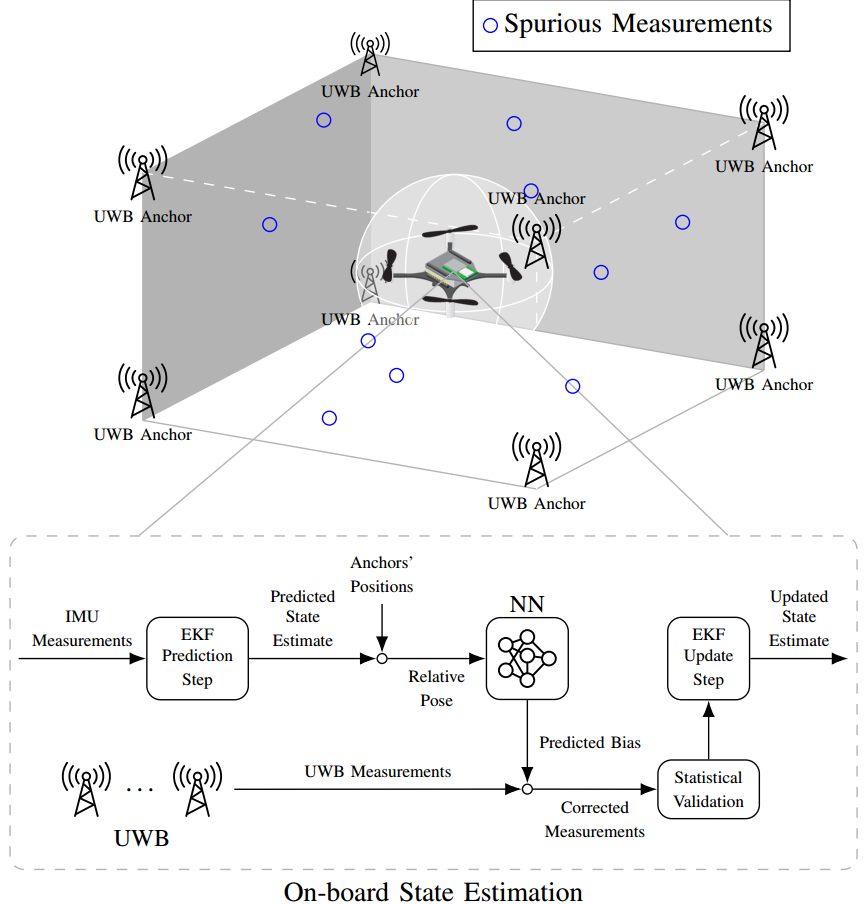
Some academics at the University of Toronto have released a paper showing different techniques in correcting the position errors in the Crazyflie ultrawideband-based indoor localization tech.  None of them are perfect, but it's interesting to see what works best

"

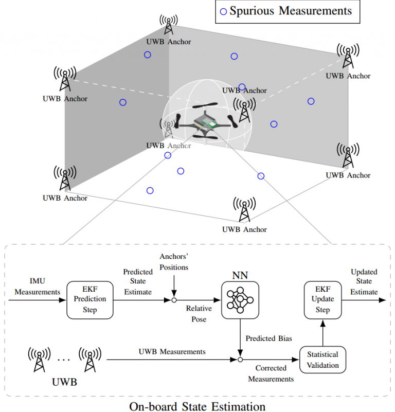
Accurate indoor localization is a crucial enabling technology for many robotic applications, from warehouse management to monitoring tasks. Ultra-wideband (UWB) localization technology, in particular, has been shown to provide robust, high-resolution, and obstacle-penetrating ranging measurements. Nonetheless, UWB measurements are still corrupted by non-line-of-sight (NLOS) communication and spatially-varying biases due to doughnut-shaped antenna radiation pattern. In our recent work, we present a lightweight, two-step measurement correction method to improve the performance of both TWR and TDoA-based UWB localization.  We integrate our method into the Extended Kalman Filter (EKF) onboard a Crazyflie and demonstrate a closed-loop position estimation performance with ~20cm root-mean-square (RMS) error.

https://www.bitcraze.io/wp-content/uploads/2020/04/Selection_003-288x300.png 288w, https://www.bitcraze.io/wp-content/uploads/2020/04/Selection_003-768x801.png 768w, https://www.bitcraze.io/wp-content/uploads/2020/04/Selection_003-240x250.png 240w" sizes="(max-width: 459px) 100vw, 459px" /> A stylized depiction of our UWB indoor localization system and the schematics of the proposed estimation framework.

Methodology

UWB measurement errors can be separated into two groups: (1) systematic bias caused by limitations in the UWB antenna pattern and (2) spurious measurements due to NLOS and multi-path propagation. We propose a two-step UWB bias correction approach exploiting machine learning (to address(1)) and statistical testing (to address (2)). The data-driven nature of our approach makes it agnostic to the origin of the measurement errors it corrects. "

More here

Read more…
3D Robotics

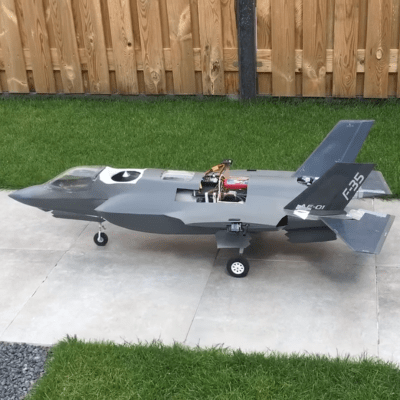
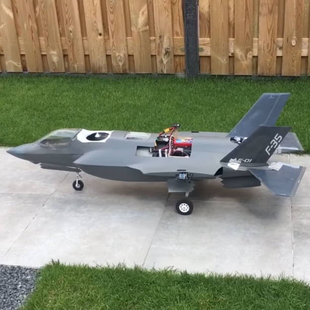
Very cool DIY F35

Not a drone (yet), but DIY and very well done. From Hackaday:

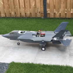
he advent of affordable gear for radio-controlled aircraft has made the hobby extremely accessible, but also made it possible to build some very complex flying machines on a budget, especially when combined with 3D printing. [Joel Vlashof] really likes VTOL fighter aircraft and is in the process of building a fully functional radio-controlled F-35B.

The F-35 series of aircraft is one of the most expensive defence project to date. The VTOL capable “B” variant is a complex machine, with total of 19 doors on the outside of the aircraft for weapons, landing gear and thrusters. The thruster on the tail can pivot 90° down for VTOL operations, using an interesting 3-bearing swivel mechanism.

https://hackaday.com/wp-content/uploads/2020/04/2020-04-26-8.png?resize=250,250 250w, https://hackaday.com/wp-content/uploads/2020/04/2020-04-26-8.png?resize=400,400 400w, https://hackaday.com/wp-content/uploads/2020/04/2020-04-26-8.png?resize=625,625 625w" sizes="(max-width: 400px) 100vw, 400px" />[Joel] wants his model to be as close as possible to the real thing, and has integrated all these features into his build. Thrust is provided by two EDF motors, the pivoting nozzle is 3D printed and actuated by three set of small DC motors, and all 5 doors for VTOL are actuated by a single servo in the nose via a series of linkages. For tilt control, air from the main fan is channeled to the wing-tips and controlled by servo-actuated valves. A flight controller intended for use on a multi-rotor is used to help keep the plane stable while hovering. One iteration of this plane bit the dust during development, but [Joel] has done successful test flights for both hover and conventional horizontal flight.  The really tricky part will be transitioning between flight modes, and [Joel] hopes to achieve that in the near future.

Read more…

1*vzCTm8Xbdt_Cf4xvQihp7g.jpeg?profile=RESIZE_710x

Observational surveillance systems rely on the capabilities of the cameras employed, but the main limiting factor is the stationary nature of the cameras in a traditional surveillance system. Now, surveillance can be achieved utilizing drones; it can be not only cost-effective but also accomplish the desired outcome more safely, efficiently and at a much larger scale. Security drones present a quicker, more economical method of aerial information collection.

Drone operations for the purpose of surveillance and security can now be automated using the FlytNow solution from FlytBase.

Benefits of Using Drones for Surveillance

Here are some of the benefits of using drones for surveillance.

  • Security drones can reach confined and narrow spaces. They can be outfitted with detectors and night vision cameras, giving them a superior vision that can detect things that a human eye cannot.

Use Cases for Surveillance Drones

Intruder Detection

0*uWBLlEI3s6GZgWQe?profile=RESIZE_710x

A drone security system can be deployed for home security or monitoring commercial properties. They can relay live video footage, eliminate blind spots both during the day and nighttime — and follow and track trespassers and intruders, thus reducing the chance of theft.

Traffic Management

0*88t7SryvdDiSaR1r?profile=RESIZE_710x

Drone surveillance can aid in real-time traffic control. They can improve situational awareness during accidents. Drones can employ analytics in traffic management that includes automatic vehicle count recognition, license plate identification, and tracking vehicular activities for improved safety and security.

Wildlife Protection

0*0LxpY1_08RJ8REEK?profile=RESIZE_710x

Forest officials face a constant threat of poachers hunting. Drones outfitted with thermal devices can replace stationary IR systems that are costly and not as effective. Surveillance drones have a fast turnaround time; they can be deployed on-demand and controlled from a base station.

Safeguarding Perimeters

0*JyW32GSCWma-CKJe?profile=RESIZE_710x

Commercial and residential properties usually have pre-defined boundaries. Surveillance drones can track a target area from a safe distance with live updates of possible threats present at/inside the perimeter. Surveillance drones can operate even at night time with the help of IR sensors, thus avoiding harm to security guards and serving as ‘eyes in the sky’.

Crowd Management


0*qKYCCkUm643AtLxN?profile=RESIZE_710x

The government can track large scale events and execute complex analytics like head-count evaluation, riot detection, and identification of law-breakers. Drones armed with speakers and beacons may be used for crowd control.

Protecting Borders

0*wHAbDP3YGIenxGcW?profile=RESIZE_710x

Surveillance drones can be used to monitor insecure border operations and dangerous zones. They can give live video feeds to security officials and other stakeholders, thus enabling them to make strategic decisions from safety.

FlytNow Enables Surveillance with Drones

FlytNow is a cloud-based, remote drone operations software that can be used to manage a fleet of drones from a single, user-friendly dashboard. The platform has intelligent features like geofencing, flight path design, precision landing, autonomous charging, collision avoidance, etc. that can be used for automating surveillance activities with drones.

The FlytNow dashboard is the command center from where operators can control multiple drones, which in turn are connected via 4G/LTE/5G. Users can stream live videos from the entire fleet of drones on a single dashboard, and can easily switch between map mode or video mode.


The FlytNow solution also integrates with the Drone-in-a-Box technology allowing enterprise users to completely automate the flight, patrol and docking cycle of a drone.

0*X01CyOmD8KtY3aGa.png?profile=RESIZE_710x


How can drones be easily, quickly adopted for security use-cases?

FlytBase offers a 28-day free trial for users to explore FlytNow Pro edition and its relevance to specific use-cases for security stakeholders. Customers can add their drone fleets, fly them autonomously, create flight plans & coordinate missions, set geo-fence and checklists, view and store live video footage and integrate drone operations into an existing system.

To get started with FlytNow visit: https://flytnow.com/getting-started-with-flytnow/

Read more…

MAVLink UDP Android Example

MAVLink UDP Android Example

This app makes your Android phone behave like MAVLink vehicle. You can connect to it using QGroundControl over UDP. The device must be either connected to the same local network, have a Wi-Fi hotspot running or a public IP address. You can also try connecting to it while using VPN or DDNS. Once connected, the Android device starts emitting heartbeat and information about its attitude, location and battery. It also receives and displays manual control messages if the ground station has hardware or on-screen joystick enabled. This example utilizes Java Native Interface. Keep in mind that generating Java libraries using mavgen or dronefleet is the recommended method of creating Android apps compatible with MAVLink. See MAVLink Developer Guide.

MAVLink UDP Android Example

Read more…

Study case : Drones against forest fire

Here is an example of how professional drones can help firefighters during forest fires. Airbot was engaged to provide a bird's eye view and crucial informations on burning surfaces and fire travel. The drone is one of the best tool for providing this kind of data and help the operations officer in his decisions and organization of ground resources.

http://www.airbot-systems.com

Read more…

This project aims to autonomously return a glider from a high altitude balloon (100,000 feet). I just wrapped up “proof of concept” autonomous glides dropped from a hexacopter. We’re ready for 18,000 foot class E flight testing, pending how our talks with the faa begins and ends.

Heres the video! Let me know what you guys think.

Read more…
Moderator

Many DIY flying projects require professional composite manufacturing.

I would like to introduce our company to you as a partner in the production of composite parts for UAV, ULA, satellites as good as a marine ship and boats.
5334385282?profile=original
The main direction of the activities of our company is services for the design, development and manufacture of products from polymer and composite materials used in the aerospace industry.
5334385092?profile=original
5334385662?profile=original
These products include:
  • hull and supporting structures of unmanned aerial vehicles (UAV) and ultralight aircrafts;
  • frame and truss structures for optical instrument making for ground, air and space use;
  • carrying and supporting structures with increased requirements for stiffness, strength, low weight, dimensional stability.

5334385689?profile=original

5334385876?profile=original
We have:
  • our own R&D department with qualified staff;
  • processing of metals and wood on CNC machines;
  • production of composite products in various technologies.

5334386472?profile=original

 The quality management system for the design, development and manufacture of products from polymer composite materials meets the requirements of ISO 9001-2015.

Sincerely you
Vladimir Khudyakov
Chief of R&D department

Read more…

In the wake of the recent COVID-19 outbreak which has affected almost every nation, government organizations and law-enforcement agencies are in search of an effective solution to fight this pandemic with minimal human interaction.

Drones seem to be an appropriate solution to tackle this menace. Apart from the transportation of emergency medical & pharmaceutical supplies, health-kits and blood samples, these unmanned aerial vehicles can effectively aid authorities in administering a state of lockdown.

A report in South China Morning Post says, the Chinese government “has adapted and co-opted industrial drones to help ensure that an estimated 50 million residents are kept at home and indoors across a dozen cities.” A fleet of drones is estimated to replace the surveillance capacity and enforcement duties of more than 100 policemen operating in dozens of patrol vehicles across a 10 square kilometer radius.

3 ways in which Drones can help manage lockdowns

While the need for social distancing and self-quarantining has already been enforced by most of the local and national government bodies in the form of curfews or lockdowns, there lies a constant necessity to monitor public spaces, in order to make sure that people are at all times following the state-mandated orders.

Equipped with thermal sensors, HD zoom lenses, loudspeakers, beacons, and disinfectant spray jets, drones are playing a crucial role in arresting the spread of the deadly virus.

1. Remote Aerial Patrolling

Remote Aerial Patrolling

As a response to the current public health crisis, drones powered with FlytNow can send ultra-low latency (<1 second) live-video feed over 4G/5G/LTE network to a cloud-based remotely operated COVID-19 command control center. The captured video streams can be further shared with stakeholders and decision-makers located anywhere across the world, to help monitor the overall social situation and take measures to control the crowd and maintain public safety.

Police authorities can autonomously capture data for a predefined/geofenced area of interest, or send the drone to specific GPS coordinates – on-demand during emergency situations. They can also combine and manage a fleet of drones with a variety of payloads, battery endurance, and capabilities. To operate 24×7, thermal camera scans can be integrated for night-time surveillance to detect a breach of lockdown protocols.

5334384259?profile=original

Drones equipped with high-definition cameras for a wide field of view, can monitor a large area including narrow roads and by-lanes and take appropriate action to curb overcrowding at several locations.

Taking advantage of the FlytDock precision-landing module, with centimeter-level accuracy, drones can be safely landed on any designated spot or even a moving vehicle, significantly reducing the risk of emergency personnel being infected by the pathogen.

Why use FlytNow:

  • Live HD video-feed at the remote station over 4G/LTE
  • Cover large area or city with fleet of drones
  • Remote gimbal control to pan/tilt drone camera to look around
  • Sharing live video feed with across police stations
  • Thermal camera integration for night surveillance
  • Automated patrol on regular intervals

2. Remote Crowd Management

Crowd Management using Drones

Public authorities using FlytNow can use drones to monitor a large area for unauthorized human gathering, since human contact is the primary way in which the coronavirus is spreading.

Built-in features like geofencing, autonomous flight, and automatic movement detection, can help authorities to catch offenders during a routine autonomous FlytNow patrol with minimum human involvement. This will allow for easy control and management of a large area with a small number of drone operators.

Fitted with loudspeakers, drones can be deployed to issue advisories, share key information, warn the public against breaching restrictions or broadcast lockdown rules and regulations, to effectively monitor and calm a panic-stricken crowd.

Drone can be the first responders in the event of an emergency like a riot, and can de-escalate the situation using onboard attachments like a siren or remotely controlled non-lethal weapon. Both the drone and its attachment can be controlled from the FlytNow dashboard. Since FlytNow supports most major drone hardware platforms, authorities can use different kinds of drones based on the situation; for example, a combination of both heavy and light drones can be used.

Why use FlytNow:

  • Live video feed from drones at the operation center for remote monitoring.
  • Automatic movement detection
  • People and vehicle counting using AI.
  • Integration with loudspeakers or sirens to monitor the crowd.

3. Remote Public Announcements

5334384065?profile=original

In a lockdown situation where the communication channels also have been shut down, drones can be used to make important announcements in an area.

Using FlytNow, authorities can dispatch a fleet of drones, which will follow a predefined path, carrying a public address system. With a message played on a loop, a fleet of drones can cover a large area compared to traditional vehicles.

Why use FlytNow:

  • Broadcast audio message to a fleet of drones equipped with a loudspeaker
  • Automated flights on a regular interval
  • Remotely transmit a message to lockdown offenders
  • Cover large area with a fleet of drones

Drones in Action Around the World for COVID-19

Drones are already in action and law enforcement officials, across the world, are already using it. In Bengaluru, India, police are using drones to catch offenders who are disobeying the lockdown.

France has also deployed drones to enforce their lockdown. Police are running aerial patrols in the streets of Nice and warning the residents not to venture out of their homes.

China has gone a step further; they have deployed heavy drones equipped with special attachments to disinfect large swathes of lands by spraying chemicals in the air.

Conclusion

Drones are already at the forefront of the worldwide battle against COVID-19. At FlytNow, we want to support public health and safety stakeholders in every corner of this world, which is why we are providing the FlytNow Pro solution free of cost to people during the coming weeks.

FlytNow Pro takes care of the complexities of managing a large number of drones, so that health workers, police, firefighters, and other public safety personnel can focus on getting the job done.

Get free access to the FlytNow Pro, sign up at https://app.flytnow.com

Read more…