All Posts (11086)

Sort by


3689495698?profile=original


I came across this while researching wireless solutions and seems very possible to create a long range WiFi connection between the GCS and aircraft using an onboard micro computer.

These are the specs that the company boasts:

--------------------------------------------------------------------------------

Processor Specs: Atheros, 6th Generation, AR5414

Radio Operation:  Proprietary 900MHz

Interface:  32-bit mini-PCI Type IIIA

Operation Voltage:  3.3VDC

Antenna Ports:  Dual MMCX

Temperature Range:  -45C to +90C (extended temp version up to +95C)

Security:  802.11i, AES-CCM & TKIP Encryption, 802.1x, 64/128/152bit WEP

Data Rates:  6Mbps, 9Mbps, 12Mbps, 24Mbps, 36Mbps, 48Mbps, 54Mbps

TX Channel Width Support:  5MHz / 10MHz / 20MHz / 40MHz

RoHS Compliance:  YES

Avg. TX Power:  28dBm, +/-1dB

Max Current Consumption:  1.10A, +/-100mA

Indoor Range (Antenna Dependent):  over 400m

Outdoor Range (Antenna Dependent):  over 50km

Operating System Support:  Linux MADWIFI, WindowsXP, Windows2000

Advanced Mobility / Quick Handoff:  WindowsXP/2000 Utility with Enhanced Mobility Driver from Ubiquiti

Cisco Support:  CCX 4.0 Supported Driver/Utility also available from Ubiquiti

------------------------------------------------------------------------------------------------------------------

They also carry ones for the 5GHz and 700MHz frequency range.  If anyone has ever used these or could see a possible usage in a UAV, please comment!


Hunter

Read more…
3D Robotics

3689495911?profile=originalThis used a car, not a drone, but it's a nice example of datalogging and data merging. With a drone you wouldn't be limited to plotting cell sites along roads. 

From the Google Earth blog:

Franz Graf knew he had a shaky mobile connection on his daily commute, but wanted to see just how bad it was. To find out, he wrote an Android app that recorded the GPS position and signal strength along his journey and then plotted all of the data in Google Earth. The result is a great Google Earth KML that shows cell tower strength in his area:

The image above was created with approximately 9,000 data points from his commute. He plans to release the app to Google Play so that others can use it, which I would love to download to drive around my area and see how it does. I have some idea of where the dead zones are, but this would give me a more concrete look at it.

He's released a sample KML filegelogoicon.gif so you can see first-hand how the output looks.

You can read more in his original post on Google+, and then the follow-up post where he plotted it in Google Earth. If he releases the app for others to download, we'll certainly let you know about it.

Read more…

FPV Multirotor Racing :)

Hey Guys, This is a little off topic but it's awesome fun!

I have created a website dedicated to this new sport! (If you can call it that)  :)

www.FPVMultirotorRacing.com

To give you an idea of what it's all about I have attached some videos from our first race season.

Events are now starting to pop up around the world so log in and get involved!

Enjoy...

Race 1 (above)

Race 2

Race 3

Race 4

Read more…
3D Robotics

If you've been wanting to put 3D sensing on your copter but were put off by the size/power or computational requirements of a Kinect, perhaps the Capri is what you've been waiting for. No pictures available until it's launched next week at CES (the above video just gives a hint of use cases in consumer electronics).

From Mashable:

When we look back at this year's CES, we may remember it as the year of the sensor. Wearable and embeddable sensor technology will be everywhere, and right there at the heart of at least some of it will be PrimeSense. The Israeli-based company created the 3D environmental mapping tech behind Microsoft's Kinect motion sensor for the Xbox 360 and, at CES 2013 in Las Vegas, PrimeSense will unveil what it calls the "World's Smallest" 3D sensor: the Capri.

As thin as a pencil and no larger than a stick of gum, Capri could herald a new era in 3D-sensing-capable products and services. As PrimeSense sees it, the Capri is small enough to go virtually anywhere: from house-cleaning robots to laptops, and from computer screens to tiny smartphones. Company execs describe it as "giving sight" to all of these devices.

PrimeSense's 3D sensor technology works by first bathing the area in front of it in a sophisticated, near- infra-red light mesh. This creates a grid that a second sensor can read. The algorithm uses the information to get a complete, live, fully 3D picture of the room -- including people and objects in it. (In Kinect, Microsoft added its own gesture-recognition software.)

While using many of the same 3D sensing technologies found in Kinect, Capri is 10 times smaller, includes a new system on a chip (SoC) and, PrimeSense representatives told me, features more powerful algorithms. The new reference design (PrimeSense is a fabless company that does not actually build the sensors) is even, according to company representatives, more affordable, a key attribute that could make it more attractive to consumer electronics manufacturers looking to add 3D motion control and interaction to their products.

At CES 2013, PrimeSense and its partners will demonstrate the tiny Capri inside a wide variety of consumer products and applications including 3D gesture-recognition signage from CoVii, real-time shopper behavior analytics from ShopPerception, a 3D interior design application from Matterport.

Read more…

http://www.indiegogo.com/blutracker

Blutracker is an ultra small Bluetooth GPS locator. It has a range of over half a Mile, the battery lasts for over 2 months in between charges, it has a full GPS engine and motion detector. There are absolutely no service fees!

Most pets that are lost, are within a couple of blocks from your home.
Track your kids in large playgrounds, parks or in your neighborhood.
Discover the exact outdoor location of the BluTracker within 10 feet at any time.
Built in motion detector notifies you if your item is moved or missing.


Also the Engadget link:

http://www.engadget.com/2013/01/03/blutracker-locator-hands-on/?m=false


They claim an unobstructed range of 2500 ft for the tracker, it doesnt record GPS coordinates but it is water resistant and looks like it would be a great lost drone tracker. Only weighs 16 g.

Read more…

January 2, 2013

http://dronemapper.com

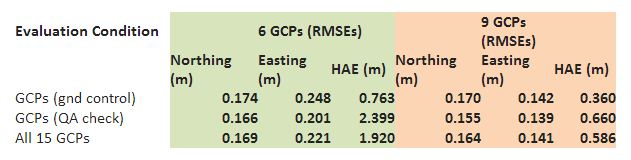
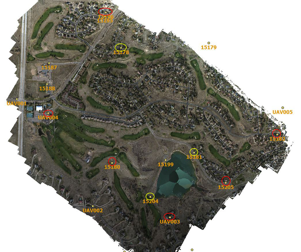
In November 2012 we described the results from an UAV survey (courtesy of Falcon-UAV) conducted over the Pinery Country Club where an area of > 1 square mile was mapped at 6.7 cm resolution. We had access to a set of precision ground control points (GCPs) (courtesy of CompassData, Inc.). The ortho below shows the Pinery area surveyed with a set of ground control used for subsequent data processing and quality control verification. The GCPs circled in red show the original 6 points used in the processing of the DEM with the other 9 used for QA verification. We had a chance to re-process this data with 9 GCPs for the DEM. The additional 3 points selected are shown circled in yellow. The table below illustrates the absolute geo-spatial accuracy improvement by the addition of GCPs.


The table compares the results of the new processing with 9 GCPs (pink or orange) against the former - 6 GCPs (light green). The evaluation conditions are 1) RMSE error in GCPs (gnd control) that were used for processing, 2) RMSE error in GCPs (QA check) that were not used for processing and 3) RMSE error for all 15 GCPs. There was a significant improvement (~ 3 X) in absolute elevation error. The easting accuracy also improved by about 50%. Have a great new year!

Read more…

ardubeacon basicIntroduction

In the last 3 months I have done a bit of thinking about an as-simple-as-possible and as-small-as-possible "follow-me"-box. The design goal is to have something so small that it can be e.g. attached to clothing by velcro and so simple that it's just switch on and go. After some googling, I stumbled upon the Arduino Fio which seems ideal for this kind of thing. I am primarily maintaining the information on this project on my personal website.

Unfortunately, I haven't had time to build one yet plus I'm lacking a functional APM-based drone at the moment, but here is my preliminary design:

Synopsis

ArduBeacon is a simple GPS beacon that locates it's current position via a GPS module and sends MAVlink waypoint messages to an ArduPilot-equipped UAV.

Status

Draft

Components

  • Arduino Fio
  • Mediatek GPS module
  • XBee pro module
  • LiPo battery

Read more…

Happy New Year to all !!!

Hello, Bonjour,

A "drône" (or U.A.V.) is visiting Marseille to get some equipments.
He first have to find a lighting system in order to navigate in the night.
Then, he will meet a photograph on the beach who will install him a camera.
Finally you will discover the real mission of the UAV.


Un drône est en visite à Marseille pour se procurer des équipements.
Il doit d'abord trouver un système d'éclairage pour naviguer dans la nuit.
Ensuite, il va rejoindre un photographe sur la plage qui va lui installer une caméra.
Enfin vous découvrirez la véritable mission du drône.

Good viewing and happy new year 2013 !!!

Bon visionnage, et bonne année 2013 !!!

JP

Read more…

Adventures in tablet flying


Finally got the macbook running on VNC, XCode to add some widgets to a screen, keychain access to manage all the passwords Apple requires, & then ran into the dreaded "Access denied" when trying to create a provisioning profile to run the program.

So developing anything for the 'pad requires either paying $100 every year to belong to the iOS developer program or getting someone you know who's already paying up to give you a provisioning profile for every device & app you develop. It's unfathomable to have to pay $100 every year to run your own code, so that just about finishes off having an aircraft that belongs to M.M.'s Apple universe. It needs to run on Android.

There are ways of rooting it, but now we're back to writing software that no-one else can run without rooting their own device with a program that requires someone somewhere to root every new version of iOS.  There's no guarantee Apple devices are going to be rooted forever.

Don't know what the future of this macbook & iPad is. They're basically worthless except for writing software for a paying customer that won't be runnable after a year. Have found the pad interface more tedious to navigate than Android, even though it's faster. The pad is also heavier than the Android.


tablet02.jpg

After deciding on continuing with just Android development, started the 4th incarnation of the ground station interface. It has now been done once in Java with a HUD, once in Java without a HUD, once in C++ without a HUD, & once in Android. The ground station is a significant amount of development, every time it's redone on a new, incompatible platform. Even graphics in Android are incompatible with the AWT libraries.

At least the Android rendering is real fast. It's much faster than those 1st 2 Java implementations. There's no lack of connection to the state of the aircraft. The ground station may actually be more complicated than the flight control software.

This phase was originally intended to be just enough to fly Marcy 1 manually. 1 day of programming ended up producing just enough to engage the autopilot or fly manually. Flying manually with the tablet is real hard.

Getting enough telemetry displayed to debug problems takes many days of work. There are graphical & text representations of many pieces of data for even something as simple as a monocopter.


When it came time to show the video preview, Java fell over. It can't get nearly the framerate of the C ground station.


shutter09.jpg


Read more…

T-Rex 600E Pro setup

3689495423?profile=original

Finally I got my T-Rex 600 in the air.

Equipped with: APM 2.5  - Radio 915 Mhz

GPS uBlox - Sonar-EZ0  -  AttoPilot

RC:  Spectrum DX8

 3689495497?profile=original

I managed to fit the APM 2.5 and the DX8 receiver into one box, keeps the wiring down and adds weight to the box which is better for vibration dampening.

3689495437?profile=original

The box is supported by 4 ear plugs acting as great vibrations damper. It works very well, you can’t feel any vibes.

3689495351?profile=original

3689495518?profile=original3689495564?profile=original

I run 2 BEC’s on a 2200 3S LiPo, one powering the servos, and the second the avionics.

3689495543?profile=original

A switch for the avionics and a connector acting as a switch for the ESC makes it easy to get ready for takeoff.  Everything is done; you don’t have to fiddle around, just flick the switch, and let the APM get ready, then push that connecter in, and go.

The Heli is powered by 5000 12S LiPo (2 6S in series), which will give me about 15min+ in the air. I provided for a second set 5000 12S LiPo’s to be connected in parallel to the standard battery pack by a connecter, this will give me a capacity of 10000 12S.

Don’t be afraid to connect LiPo’s parallel; if you do it right there is no harm to you and the LiPo’s.

See link’s    LiPo parallel charging  1      LiPo parallel charging  2

This setup might give me about 25min in the air, and if I fit the Heli with asymmetrical rotor blades,

I might get 45min airtime.  

I think this Heli wil be a great platform for FPV flying, which I will look into in the very near future, after gathering more experience with this setup.

The first flights proofed already very stable in Stab and AltHold, and I was 15min+ nonstop in the air. The average current draw is just 15Amp.


My RX setup with Spectrum TX8 is surely unusual; I fly the Heli in Airplane mode.

Flying with an autopilot you don’t need swash mixing or the link between throttle and collective.  You have a flat throttle curve anyway.

I linked the Knob to Aux1 which is my throttle and the throttle curve from the Airplane is my pitch curve. The rest is pretty much the same as you have it in Heli mode.

The pros of this are:

  • In AltHold you can take the collective stick slowly way back until the Heli starts descending, without cutting in to the descending part of the throttle curve and interfering with the motor speed.
  • You can adjust the rotor speed during flight (compensate for voltage drop).
  • You can’t accidentally kick the stick forward and start the motor on the ground.
  • If 1 of the 3 pitch servos gets stuck, you have much more a change to land the heli undamaged, just leave the collective and adjust the motor speed slowly so the heli will descend.


It works and flies very well for me.

You could control the throttle with the Knop in Heli mode as well, but you have to sacrifice 1 RC channel, because in Heli mode the pitch and throttle are always linked.

I’ll keep you up to date with my experiences and further developments.

Read more…

UAV Portable Base Station

3689495361?profile=original

I found that a conventional laptop computer is fragile for use in the field and decided to create my own ruggedized PC that would be suitable for use in the field and the workshop. Having upgraded my desktop, I have a spare socket AM3 motherboard. The motherboard has an integral video adapter, so will not require a bulky graphics card. To power the PC, I will use a 12 volt ATX power supply. A 19" Samsung LED LCD will be used. The screen comes with a 14.2V mains power supply, this is more than the intended 12v input. I attempted to power the screen with 12V but it would not switch on. To ensure the the LCD will have a consistent 14.2V input, I will use a buck-boost regulator. This means the PC will be able to take a wide input range from 10-20V.

The case is constructed from sheet aluminum and 1" aluminum equal angle and held together using M4 stainless-steel cap headed bolts. I think it should be up to the job when it's finished.

3689495243?profile=original3689495324?profile=original3689495392?profile=original3689495460?profile=original

Read more…
3D Robotics

3689494987?profile=original

We had a great year here at DIY Drones. Membership is growing at the fastest pace ever (about one new member every 35 mins), as are all the other measures of participation, such as number of blog posts, discussions, comments and pictures/videos.

Traffic is also growing nicely, and we now do more than 1.6 million pageviews per month.

3689495155?profile=original

On the development side, 2012 was a huge year. Here are some of the highlights:

3689481753?profile=originalSoftware:

  • ArduCopter reaches maturity (2.7 and beyond)
  • ArduPlane reaches excellence, winning the Outback Challenge (team shown at right) and the Sparkfun AVC
  • ArduRover reaches adolescence ;-)
  • All codebases now being prepared for next-gen ARM-based hardware (PX4 and beyond)

New 3DR Hardware

Our hardware partner Jdrones also grew spectacularly this year, with exciting new products and new production facilites, but I'll let Jani write that post ;-)

2013 Preview 

Along with a flood of new products and continued software evolution, the big changes you'll see around here in 2013 are going to be in the websites, which are due for major improvements. 

  • The ArduCopter, ArduPlane and ArduRover manuals, which are now in the Google Code Wiki, are all being ported to a much better platform (Wordpress, with wiki enhancements). This will make them better looking, easier to navigate and easier to maintain. Look for this by March. 
  • Product support for those codebases will move to Wordpress forums, integrated with the manuals. This will allow DIY Drones to return to its primary function as a community for all things amateur UAV, without being too overwhelmed by the noise of tech support for individual products.
  • DIY Drones, which is hosted on Ning, is also due for an upgrade/redesign, which Ning is planning in Q1. We're working closely with them on this, and will address many of the current limitations of this platform, both in the outward appearance and the back-end tools for the moderators, to let them do a better job of keeping this community high-quality
  • The 3D Robotics site will be completely relaunched, with its own corporate presence, new ecommerce system and back-end ERP system. It will also host good-looking landing pages for ArduCopter, ArduPlane and ArduRover, to simplify things for newcomers.

Finally, a huge thanks to all the members, Moderators and developers who worked so hard in 2012 to make this our best year ever. This community has become something extraordinary, and every day I'm blown away by the ideas, insights, energy and creativity of the members here. Drones are hot!

Read more…

ATLANTIC OCEAN, SWAT TEAM AND CONSERVATION DRONES

A fitting last post for what has been a most exciting 2012, which saw the founding of ConservationDrones.org and ResearchDrones.com, hundreds of successful drone missions in Asia and Africa (and a couple of epic crashes as well), and exciting new partnerships with conservation groups and colleagues around the world.

This is video footage from a December drone training mission on the beaches of Pongara National Park in Gabon, off the Atlantic ocean, conducted by Remo Peduzzi of ResearchDrones.com for WWF Netherlands, Team Libreville.

Not only did the drone capture detailed video and images of turtle nests on the beach, but it also had a serendipitous encounter with a Gabonese SWAT Team, which was parachuting down to the beach from a helicopter.

Looking forward to another productive and exciting year to come in 2013!

-ConservationDrones.org & ResearchDrones.com

Read more…

3689494693?profile=originalI've had this idea in my head for some time now, finally got serious about sketching it out.

3689494588?profile=originalYes, I know that all the props are pushers ; ) I couldn't find the tractors and wanted to get some pics up anyway. First flights will all be with gemfan carbon plastics, but I'm stoked to use these wooden props once everything is verified to function in flight. She looks a little fat in the rear I admit, but that is 5.6 Ah 4s in a hard case. All up weight is 2.71kg.

3689494788?profile=originalSpindly landing gear fills in for top-secret next gen gear that can't be shown yet. This configuration has some Klingon Bird of Prey in it, that's obvious.

The goal for this project is a clear view, roll/tilt gimbal that utilizes the waterproof GoPro housing and is positioned coplanar with the motor mounts. 

I'm using a pull/pull set up for both axes. It works well, but a little more dialing in will be needed. I'll get a video up tomorrow after I clean my shop. 

3689494914?profile=originalTilt control and video out are fed down the central rotating axle. This axle and gopro housing are the only moving parts, both riding on nylon bushings. Tilt pivot is vibration isolated from airframe. "Manually printed"- pivot sockets, control horns, and video out connector are attached to waterproof gp housing.

3689494858?profile=original

Stiffen and lighten this yoke, increase the diameter of the axle, print some proper gopro attachments (Rostock-Kossel in the works!!) The camera housing is easily opened without removing from the yoke.

3689494883?profile=original

Belly up view. Remember, this is just a rough draft, plenty of little changes to make for MkII, starting with a completely different frame. I'm done with the hub and spoke form. Multi-copters are basically just a packaging exercise, and I keep wishing for a different shape while trying to integrate all these sweet-ass robot parts. The next frame will be a folding Roman five, a "V" with horizontal bars top and bottom.

I can remove a lot of weight from this of course, the motor mounts, arms, wiring, etc. I like to make things heavy and adjustable at first, then begin to lighten and lock down everything.

The important part is the parallel rails and the gimbal arrangement, that's what i want to develop a bit more. The roll axis motivation could come from any number of sources, I've used pull/pull for it so the servos could be grouped and positioned optimally for weight balancing. 


Read more…
100KM

so here is the latest news concerning the techpod:

   Got the production unit in.

dsc00702.jpg?w=677&width=354dsc00707.jpg?w=677&width=210

dsc00717.jpg?w=299&width=158

dsc00727.jpg?w=677&width=200

  You can see more at the newly revamped hobbyuav.com. Also we now have an actual online store with paypal and credit card payment options and international shipping as well. Check out the full gallery for more picteres of the different parts.

i am very impressed with the quality. The tops of the wings are glass smooth, the bottoms have only minimal bumps from the steam vents used in the molding process.. Every thing fits well and everything seems plenty stiff to withstand sudden maneuvers.

Thanks guys!

Wayne

wpid-0008.jpg?w=499

Read more…

Aerial Mapping Easter Island @ 15 cm GSD

December 25th, 2012

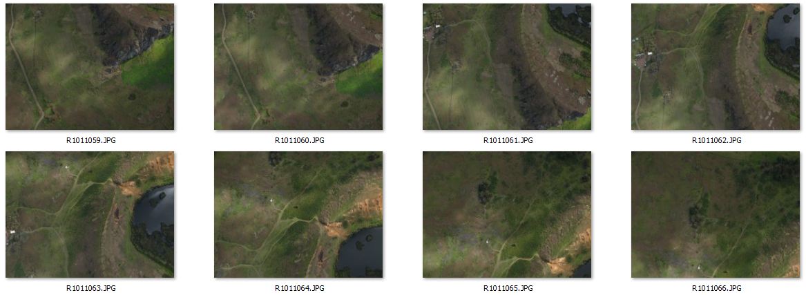
Back in May we processed an interesting data set from Easter Island, Chile at 30 cm / px GSD. Kim Anh Hoang from the Easter Island Statue Project used the 30 cm Orthomosaic and DEM to produce a 3D Flyby of Rano Raraku and an EISP excavation site. We've now re-processed the data at the highest resolution possible, 15 cm / px GSD. The original imagery was obtained using an autonomous UAV flying at an elevation (AGL) of ~330 meters with a consumer level Ricoh GR Digital III camera. The GR Digital III is not GPS enabled, so geo-tagging was accomplished locally using the UAV flight controller logs. In total, 140 NADIR images were shot at 10 mega pixel covering an area of 3.7 km^2.


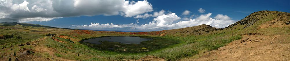
"Rano Raraku is a volcanic crater formed of consolidated volcanic ash, or tuff, and located on the lower slopes of Terevaka in the Rapa Nui National Park on Easter Island. It was a quarry for about 500 years until the early eighteenth century, and supplied the stone from which about 95% of the island's known monolithic sculptures (moai) were carved. Rano Raraku is a visual record of moai design vocabulary and technological innovation, where 397 moai remain. Rano Raraku is in the World Heritage Site of Rapa Nui National Park and gives its name to one of the seven sections of the park." Rano Raraku - Wikipedia


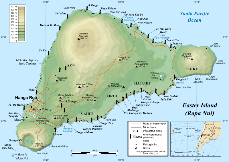
A map of Easter Island/Rapa Nui, showing the three main volcanoes Terevaka, Poike, Rano Kau, as well as Anakena beach, the islets including Motu Nui. Modern Hanga Roa and Mataveri International Airport, the ruins at Orongo and the quarry at Rano Raraku. It marks major ahus with moai.


Above we've displayed a small subset of 8 images from the original 140. We recommend obtaining more overlap and imagery for an area of interest (AOI) this size.


Contact Us for the full geo-referenced downloadable data set.

Read more…

3689494753?profile=original

Over the last few of months I have been making regular visits to the lab of Dr. Alejandro Ramirez-Serrano at the University of Calgary.  Called the Autonomous Reconfigurable/Robotic Systems Laboratory (AR2SL) it specializes in research related to (from the web site): 1) Ground and aerial unconventional unmanned vehicle systems (UVS), 2) reconfigurable intelligent mobile robotic systems, 3) swarm robotics, 4) intelligent control for UVS, and 5) search & rescue applications of mobile robotics.

Roughly once a month, and on a very informal basis, a tour is organized where there is a walkthrough of the lab followed by lunch and discussion.  The objectives are simple: expose Dr. Ramirez-Serrano's work to a broader audience, and try and coalesce interest in UAV work in Southern Alberta.  Thought is also being given to setting up a semi-permanent Meetup group to pursue these objectives.

If you would like to be included in one of these upcoming tours, by all means, please get in touch and we can make the necessary arrangements. A photo from a recent tour, which shows the Evader bicopter prototype.  Additional pictures can be found at shard Photo Streams for the tours that ran on 2012-10-18 and 2012-12-13.  

Read more…