All Posts (14039)

Sort by

NestGen 2022 is a global virtual conference on drone autonomy dedicated to building a rich network of industry experts and adopters of drone-in-a-box (DiaB) systems.

Why NestGen?
While there are numerous conferences and events that cater to the drone industry at large, there is a dearth of focus on drone autonomy in general and DiaB systems in particular. NestGen is an effort to bring the focus on these critical sections of our industry, which will be the key drivers of growth as we transition from manual operations of drones to full autonomy.


We have often imagined a world where automated drones are able to help us with aerial monitoring, security, inspections, and various other commercial applications with little to no human intervention. It’s now time to make that happen!


What’s happening in NestGen?
NestGen is a one-day event that features 11 hours of expert sessions, deep-dives, product updates & announcements, application-specific breakouts, and a boatload of ways to network and engage with the fellow drone community members, virtually.

https://www.youtube.com/watch?v=xRop6cDUH1E

Read more…

9893416282?profile=RESIZE_710x

Topodrone, based in Switzerland, designs and produces professional surveying solutions for UAV mapping and 3D modelling based on the most popular DJI drones, as well as providing comprehensive topography and mapping services.

Topodrone produce the most cost-effective multi-band GNSS PPK modules for DJI drones for Mavic 2 Pro, Phantom 4, Mini 2 and Inspire 2. The kits are extremely easy to install and simple to use. Converted drones are also available ready-to-use. These drones are the ideal affordable solution for mapping at centimeter accuracy with no Ground Control Points, and are fully compatible with Emlid Reach GNSS receivers for the ultimate surveying package.

 Surveyors can now get Topodrone Products from Aeromao, the dealer for North America.


 The two most popular products are:

 Topodrone DJI Mavic 2 Pro PPK

The most compact survey drone with folding arms, maps of up to 30 hectares of high-precision aerial survey in 30 minutes of flight. Highest image resolution among survey drones with 20 MP cameras.  Almost half the price of a DJI Phantom 4 RTK drone.

Available for only $5,117 CAD

https://www.aeromao.com/product-category/topodrone-dji-ppk-drones/


 TOPODRONE DJI Phantom 4 Pro v2.0 PPK

Very compact survey drone with a global shutter with a capacity of up to 27 hectares of high-precision aerial survey in 25 minutes of flight.  20 MP camera's global shutter provides increased accuracy.

  • The best survey drone to complete aerial survey of the building's façade.
  • Highest resistance to wind among survey drones of its class.

 Available for only $5,499 CAD

https://www.aeromao.com/product-category/topodrone-dji-ppk-drones/


Already have any of these drones?

Customers can also buy just the upgrade kit and turn an existing drone into an accurate surveying professional tool, obtaining up to 3 cm accuracy in XYZ and 1 cm resolution resulting in highly accurate orthomosaics and 3D models.

 Kits are available at only   $2,714 CAD

 Instructions for installation are full support is provided.

 More information at:  https://www.aeromao.com/product-category/topodrone-dji-ppk-drones/

 More information will be added to Aeromao’s store soon.


Read more…

I have upgraded my quadcopter XJ470 with a Skydroid T12 radio, an OAK-D depthAI stereo camera and a Raspberry Pi 4 companion computer. This configuration enables state-of-the art artificial intelligence drone piloting. The skydroid t12 enables long distance telemetry and video. The OAK-D combines depth measurements and artificial object detection. The RPi 4 has an WiFi access point enabling remote desktop communication by means of VNC. Avoidance python scripts are uploaded to the RPi 4, generating mavlink drone messages controlling the quadcopter. A test video demontrates the new features.

Read more…

Inverted pendulum on a drone

From Hackaday:

[Nicholas Rehm] works during the day at the Applied Physics Laboratory at John Hopkins, Maryland, so has considerable experience with a variety of UAV applications. The question arose about how the perseverance mars rover landing worked, which prompted [Nicholas] to hang a rock under his drone, attached via a winch. This proved to be interesting. But what is more interesting for us, is what happens when you try to attach an inverted pendulum to the top of a drone in flight? (video embedded, below)

This is a classic control theory problem, where you need to measure the angle of the pendulum with respect to the base, and close the loop by calculating the necessary acceleration from the pendulum angle. Typically this is demonstrated in one dimension only, but it is only a little more complicated to balance a pendulum with two degrees of freedom.

[Nicholas] first tried to derive the pendulum angle by simply removing the centering springs from an analog joystick, and using it to attach the pendulum rod to the drone body. As is quite obvious, this has a big drawback. The pendulum angle from vertical is now the sum of the joystick angle and the drone angle, which with the associated measurement errors, proved to be an unusable setup. Not to be discouraged, [Nicholas] simply added another IMU board to the bottom of the pendulum, and kept the joystick mechanism as a pivot only. And, as you can see from the video after the break, this indeed worked.

The flight controller is [Nicholas’] own project, dRehmFlight (GitHub), which is an Arduino library intended for the Teensy 4.0, using the ubiquitous MPU6050 6-DOF IMU. [Nicholas] also made an intro video for the controller, which may prove instructive for those wishing to go down this road to build their own VTOL aircraft. The code for pendulum experiment is not available at the time of writing, perhaps it will hit the GitHub in the future?

Read more…

Hello all,

I have a question. Could anybody direct me to where I can find learning material or some schematics on long range FPV communicarions? I mean any online class, book, website is welcome at this point... I'm trying to learn design principles for 10km or above Video/Data link electronics.

Thanks in advance.

Umur

Read more…

Hi, my name is William. I am developing a large unmanned VTOL aircraft similar in function to the Convergence RC model. The 2 tilting motors in front motors run on 14S batteries. The one in back needs a 28S battery. 

I would like to operate the motors using only two 14S batteries. My idea is to connect the 2 batteries in series for the back motor and tap off each battery for the front motors. I will be using Opto ESCs, so that the input signal ground is issolated from the power ground.

Has anyone tried this before? Does anyone think it will not work?

Thanks, William

Read more…
3D Robotics

Making a custom drone navigating without GPS

From DroneDJ:

Nicholas Rehm may be a full-time aerospace engineer, but his success in constructing a DIY self-flying drone that avoids obstacles without standard GPS tech aboard still merits a standing-O. He also gets a deep bow for describing the serious wonkitude involved in a thoroughly entertaining way.

Rehm is no neophyte to homemade drone projects – with or without GPS assistance. Given the education and experience required for his day job, no doubt, his DIY endeavors tend to be a great deal more complex than the typical amateur craft that get (as woebegone Soviet citizens used to put it) “snotted together.” His YouTube page contains over a dozen instructional videos of how he devised and assembled his way-complex UAVs, usually relying on wry understatement or irony to cut the thickness of complex processes he’s detailing. 

Quite clearly, Rehm not only brings his work home with him, but indeed creates additional labors of love to infect others with his passion for drones and other aerial craft.

“I am a full-time aerospace engineer, but I like to work on interesting flying projects in my free time: drones, airplanes, VTOL, and everything in between,” he says on his video page. “My goal is to share what I learn along the way and make advanced concepts less scary.”

https://dronedj.com/wp-content/uploads/sites/2/2021/11/Rehm.jpg?resize=155,86 155w, https://dronedj.com/wp-content/uploads/sites/2/2021/11/Rehm.jpg?resize=655,364 655w, https://dronedj.com/wp-content/uploads/sites/2/2021/11/Rehm.jpg?resize=768,426 768w, https://dronedj.com/wp-content/uploads/sites/2/2021/11/Rehm.jpg?resize=1024,568 1024w, https://dronedj.com/wp-content/uploads/sites/2/2021/11/Rehm.jpg?resize=1536,853 1536w, https://dronedj.com/wp-content/uploads/sites/2/2021/11/Rehm.jpg?resize=2048,1137 2048w" sizes="(max-width: 2998px) 100vw, 2998px" layout="responsive" disable-inline-width="" i-amphtml-layout="responsive" i-amphtml-auto-lightbox-visited="" lightbox="i-amphtml-auto-lightbox-1" on="tap:amp-lightbox-gallery.activate">Rehm.jpg?w=1024https://dronedj.com/wp-content/uploads/sites/2/2021/11/Rehm.jpg?resize=155,86 155w, https://dronedj.com/wp-content/uploads/sites/2/2021/11/Rehm.jpg?resize=655,364 655w, https://dronedj.com/wp-content/uploads/sites/2/2021/11/Rehm.jpg?resize=768,426 768w, https://dronedj.com/wp-content/uploads/sites/2/2021/11/Rehm.jpg?resize=1024,568 1024w, https://dronedj.com/wp-content/uploads/sites/2/2021/11/Rehm.jpg?resize=1536,853 1536w, https://dronedj.com/wp-content/uploads/sites/2/2021/11/Rehm.jpg?resize=2048,1137 2048w" alt="" />

Which is exactly the miracle he pulls off in this video describing how he made a DIY drone that avoids obstacles without using the standard GPS tech aboard most UAV – and without even needing to be connected to outside communication feeds. Which not only makes his autonomous vehicle immune to collisions or outside jamming devices, but immeasurably cool to boot.

Rehm’s initial idea was to find a viable alternative to habitual autonomous navigation and obstacle avoidance systems. Those require a pre-planned flight path to be entered on a map, waypoint-by-waypoint, that the craft follows in sequence until it reaches the designated destination.

“The drone is actually quite dumb in that it can only fly from one point to the next with no real perception of the world around it, needing to be told what to do for every step of the way,” Rehm explains in the video. 

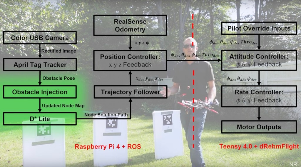
To remedy that, he replaced the foresworn GPS with algorithms powering Google Maps. Those interact with data picked up from the drone’s onboard internal measurement unit, cameras, altitude gauge, position and movement detectors. All of that, orchestrated by a Raspberry Pi 4 using a Robot Operating System, allow the craft to find the way around obstacles it encounters as it advances.

Unlike sequentially progressing as in waypoint-based systems, Rehm’s drone is only told where to go and eventually return to, and is on own from there. As the video demonstrates, when the UAV encounters an obstacle, its programs detect a clear but limited area to either side to take to avoid them. That confined free space detection range is used each time the advancing UAV encounters an obstruction, taking a baby step route around each, but otherwise flying freely until it reaches its destination.

YouTube Poster

Rather breezily brushing aside the formidable math and engineering needed to pull a feat like his off, Rehm reminds viewers his DIY project is just one of many they can take to greater heights.

“Once you have the building blocks in place for a complex project like this, it’s pretty easy to go back and expand on those individual elements to make the overall system more capable,” Rehm says at the end of the video, his GPS-less drone hovering a few feet away. “For example we could swap out that AprilTag detection algorithm I used for something more robust to maybe detect buildings; or we could expand our motion planning from two dimensions to three.”

Easier for Rehm to say (and believe) than most, though it’s clear he’s sincere in closing out by expressing the motivation for his cutting-edge “snotted together” drone videos.

“I hope you learned something interesting.”

Read more…

DIY - Open Board Architecture for Linux - OBAL

Obal3D.png


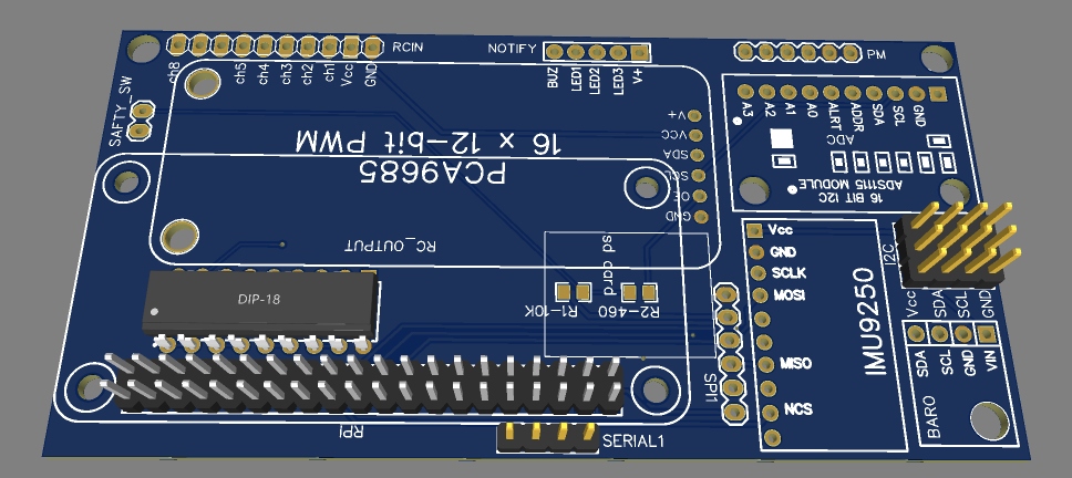
This board is one of many Linux-Based boards that run Ardupilot. What is spepcial about this board is that has very simple architecture. Only necessary components has been added. No extra or redundant components. However it is still expandable and more sensors can be added if you want to.

The PCB shield is designed to use simple breakouts available in the market. No special soldering skills or components are required. You can build from scratch your own board using this PCB and learn the basic architrecture of Ardupilot boards and move to next step where you add extra sensors and ending by building your own board.

Yes this board acts more like a developing kit rather than a ready-to-fly board. Again if you want to fly with it you can but then do not use pin headers and solder the breakouts directly on the board.

On the software side. OBAL board does not have special drivers. All you need to do is to clone ardupilot repository and compile the code. Nothing special, nohting hidden , completely open source.


For more information please check Ardupilot Documentation. Also there are some videos that describe in details how to build it, compile and deploy the software. Have fun :)


Read more…

Flying drones over long distances or scanning large areas is always challenging. One of the biggest problems is the limited drone communication range. Of course, a drone can fly along the route pre-developed in UgCS, but receiving drone telemetry or sending commands over long distances is not always possible.

For DJI, one of the most widespread drones in the world, the problem is aggravated by the fact that nearly all models require a remote controller with a very limited communication range.

To tackle this problem, we came up with the following ideas:

  1. communicate with a drone via the LTE/4G/5G mobile network
  2. use an antenna with a narrower radiation pattern
  3. use more powerful transmitters and wider communication channels

We investigated each idea and this is what we found. 

1. Communication with the drone via the LTE/4G/5G mobile network

That sounded promising since mobile networks are expanding all over the world and mobile communications are covering more and more territory. Of course, flights sometimes take place in remote areas without LTE/4G/5G, but mobile network communication is OK for most use cases. So, we chose this option as the main one.

2. Antenna with a narrower radiation pattern

Using an antenna with a narrower radiation pattern can increase the communication range, but not dramatically. This option has an inherent challenge: a narrow pattern antenna must track the drone position and rotate accordingly. We began working on it because it seemed interesting, so we will publish a post about it in the future. Stay tuned!

3. More powerful transmitters and wider communication channels

Officially there are no devices yet that are compatible with DJI's most popular drones, so this option was discarded from the very beginning.

Controlling a DJI drone via 4G

To try creating a LTE/4G/5G-controlled drone, we opted for DJI as one of the most common drones on the market. We decided to place a 4G modem on the drone and connect it to an automatic flight controller. The analysis showed that there was only one way to do this: use DJI OSDK (https://developer.dji.com/onboard-sdk/documentation/introduction/homepage.html), an additional on-board computer (for example, Raspberry PI or NVidia Jetson Nano) and 4G modem plugged into it.

9738527297?profile=RESIZE_710x

The DJI OSDK requirements specify the list of compatible drones: all Matrice models and those based on the A3 flight controller.

We assembled an A3-based test bench for local development and debugging. And after successful tests, assembled the full system. The photo with the equipment installed on M600 is provided below.

9738534262?profile=RESIZE_710x

We also decided that the application should not only ensure integration with DJI OSDK, but act as a full-fledged UgCS onboard VSM (vehicle specific module). That is, the application should allow the drone to connect to UgCS directly via LTE/4G/5G.

As soon as the prototype was ready and debugged, we performed some test flights with Matrice 600.

9738535659?profile=RESIZE_710x

Moreover, one of these flights included crossing the border, and during it, we tested the switching between two mobile operators. For details, see https://sph-engineering.com/news/first-cross-border-drone-flight-on-the-mobile-network-with-ugcs

As a result of all the experiments, we had an application that meets the following requirements:

  1. The application can be installed on the drone using an additional Raspberry PI computer.
  2. The application allows controlling your DJI drone directly from UgCS without additional remote control or mobile app.
  3. The drone connects to an UgCS server via a LTE/4G/5G network.
  4. UgCS onboard VSM behaviour can be modified to support specific requirements: for example, to add some actions during takeoff or manage a non-standard payload.

Considering that our solution could be useful to others, we decided to make it publicly available to simplify the development and use of various solutions based on UgCS and DJI OSDK. You can download the source code here https://github.com/ugcs/dji-onboard-vsm

Here are possible use-cases for the application:

  1. The drone can be managed via the LTE/4G/5G mobile network, which significantly expands the range of drone use cases in areas covered by mobile Internet.
  2. This solution can help air traffic control bodies to easily track the drone, thus replacing ADS-B to some extent.
  3. Additional payload management features can be added.
  4. Instead of mobile communication channels, you can use any other data links that support TCP and UDP packets for video transmission.
  5. You can use our source code as an example and develop your own solution based on the DJI OSDK and UgCS.


Read more…

Hi everyone, 

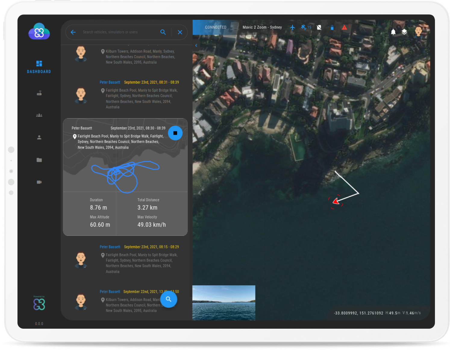
I am Michal Weiss, and I'm currently working on a new product with my team to enable remote access and control for any Mavlink vehicle through a web browser. 

Our product makes it easy to see the video, telemetry  and manual control your vehicles from the browser.

I wanted to reach out to the community to check if anyone is interested in trying it out.

If you are interested, I'll be able to provide you with free access + hardware to start playing. (No commitment or assosiated costs) 

Please feel free to reach out via email or message me here.

michal.weiss@advancednavigation.com


For more info : https://www.cloudgroundcontrol.com/

Here's a screenshot from our platform:

CGC-tablet.png


Looking forward to hearing from you.

Michal

Read more…

Taking aim at the growing connected drone market, MMC has recently announced its “Feitian (meaning Flying Apsaras) Cloud” series of products and services to all UAV manufacturers. “Feitian” is specially designed and developed for not only government entities, enterprises but also individual UAV users. MMC will keep bringing the latest UAV-based cloud computing, big data and AI technologies to all customers in the world.

%E5%B0%81%E9%9D%A2-1024x436.png

Empowered by continuously scientific and technological innovations, “Feitian Cloud” UAV-Based Data Computing System offers more sufficient UAV industry solutions, which makes contributions to build an opening Cloud-based ecosystem, promoting industrial network construction and facilitating the accomplishment to digital transition for entire industries.

111111-e1631268378418-1024x522.png

As of now, “Feitian Cloud” UAV-Based Data Computing System has linked Public Security Cloud, Huawei Cloud, and etc., boosting profound development to UAV-based services and applications among MMC, law enforcement in Ministry of Public Security and large enterprises.

2222-1024x522.png

Read more…

MMC Enterprise Drones for Oil and Gas Inspection

Nowdays oil and gas are important components of the global energy field, and the “talent” of drones in inspections is gaining increasing recognition. In addition to power inspections, oil and gas pipeline inspections are the main operating scenarios for drone inspections. Due to the length of oil pipeline routes, and most of the access areas are relatively remote and the topography is complex, traditional manual inspections are no longer sufficient.

MMC UAV solutions to oil and gas inspection, is low cost, high efficiency, high safety factor and other characteristics, greatly reducing the inconvenience and errors caused by manual inspection, which is an effective way to operate safely for oil transmission pipeline, natural gas, etc.

oil-and-gas-inspection-300x204.pngDrones-transmit-video-in-real-time-300x185.png Safety-operation-inspection.png

Today, drones are becoming more widely used in the petroleum industry. There are more and more application scenarios, such as exploration, site selection, construction progress inspection, operation safety inspection, production and storage facility inspection, marine accident monitoring, geological disasters, and emergency management of fires during flood seasons.

With the continuous progress in technology and standards, the integration and development of drones and the petroleum industry will create more value.

Welcome to visit our website: https://www.mmcuav.com/

Read more…

A quick update on the recent expedition by The Ocean Clean Up and Oceans Unmanned using amphibious drones in an espectacular and remarkable clean up operation

9602956882?profile=RESIZE_710x

https://twitter.com/TheOceanCleanup/status/1438156325184229379?s=20https://twitter.com/TheOceanCleanup/status/1438156325184229379?s=20https://twitter.com/TheOceanCleanup/status/1438156325184229379https://twitter.com/TheOceanCleanup/status/1438156325184229379?s=20https://twitter.com/TheOceanCleanup/status/1438156325184229379?s=https://twitter.com/Thhttps://twitter.com/TheOceanCleanup/status/1438156325184229379?s=20eOceanCleanup/status/1438156325184229379?s=2

Read more…

New! Drones for Good Picture Book Series for Kids!

9575611473?profile=RESIZE_710x

Hi there! We've just launched our new and inclusive Picture Book Series on Drones for Good!

The series focuses on local expertise and drones for good. The books are written by and with local drone experts, editors and illustrators from Africa, Asia and Latin America. The first book in the series focuses on mangrove protection in Panama. This project is a partnership between Flying Labs and WeRobotics. Each book in the series is based on a real-world drones-for-good project led by Flying Labs and their local partners. We'd be so grateful for your kind help in spreading the word. Feel free to retweet us!

Check out the trailer for our first book on The Magic of Mangroves and get your copy from our Kickstarter page!


Read more…

The COVID-19 pandemic revealed several operational challenges in performing manual drone flights for numerous use cases such as inspections and progress monitoring. Consequently, employing automation technology has become more of a necessity than a nice-to-have. However, the monolithic nature and prohibitive cost of incumbent drone-in-a-box (DiaB) systems for autonomous UAV operations have lowered the adoption of such solutions. Hence, several companies are working towards modularizing the DiaB stack to reduce cost and increase adoption.

These companies are building automated docking stations that support charging, cooling, and landing for popular, off-the-shelf drones such as the DJI Mavic, Matrice, and Phantom series.

Such systems can enable users to easily deploy fully automated drones (of their choice) for a wide range of applications, such as automated aerial security, asset monitoring, and public safety, at a fraction of the cost of current DiaB systems.

In this article, we highlight the salient features of some of the best turnkey DJI-compatible docking stations in the market that you can leverage based on your geography, business model, and use case. Apart from common features such as cloud connectivity, remote control & telemetry, auto-charging, and interactive GUI, each dock brings a unique set of capabilities to the market, which we have attempted to highlight. It is worth noting that most of these drone nests can be further customized on request or by installing addons.

Hextronics Global Advanced (USA)


The Hextronics Global Advanced supports a rugged, waterproof design that is ideal for a wide range of indoor/outdoor environments and can operate in a temperature range of -20 to +50 °C (-4 to +122 °F). Although the most recent model weighs up to 45 kg (~100 lbs), a clear differentiator of this docking station is its IP66-level enclosure and highly efficient in-house charging feature, where a robotic gantry autonomous performs battery swapping for the drone. Further, the base unit can hold up to 6 additional batteries and keeps them fully charged while the drone is away on routine missions. And despite its small and lightweight design, The Global Advanced does not compromise on any key feature, offering a groundbreaking downtime of just 1.5 min. It is compatible with the DJI Mavic 2 series of drones and its landing pad is installed with LED lights to enable night landing.

IDIPLOYER MP2.1 (UK)


Coming in at only ~30 kg (~66 lbs), the super-light IDIPLOYER MP2.1 is built with a rigid aluminium frame and contains no moving parts such as centering bars or robotic arms for landing or charging the drone. Engineered with insulations that conform to IP65 standards, the station is installed with thermostatic heating and peltic cooling systems for extreme temperature regulation. A contact-charging-based docking station centered around a simple and durable design, the MP2.1 is the ideal choice for large-scale deployments of DJI Mavic 2 fleets. The chassis is fitted with long-range antennas and LED lights for better connectivity and real-time visual alerts, respectively. The station can be secured to any surface such as rooftops or vehicles and contains electromagnetic locks to prevent theft. Furthermore, the rear access panel comes with cam locks, although users have the freedom to add security/locking systems of their choice, including a custom installation of external CCTV cameras.

Heisha D80 (PRoC)


Heisha Tech offers enhanced security and durability with its sturdy designs. Their models are heat-resistant, corrosion-proof, and rainproof monsters with an International Protection (IP) rating greater than 54. Owing to its high reliability and cost-efficiency, Heisha’s docks feature a contact-based charging system; other useful add-ons such as solar panels, weather stations with digital sensors, surveillance cameras, extended range antennas, and loudspeakers are also provided with the dock bundle.

The D80 Drone Dock is highly customizable owing to its modular design: the unit consists of 3 main modules, viz. control, charging, and cooling, and an all-aluminum alloy canopy that has been tested for rigidity. So if you’re a custom drone developer and your hangars have docking and battery-swapping capabilities, you only need a control unit, which is a component that Heisha provides separately. What’s more: the D80 redefines drone agnosticism in the DiaB space, as it is compatible with almost every commercial drone available today, including the DJI Mavic 2 and Mavic Mini series, Phantom 4 RTK, Autel EVO II, Yuneec Typhoon, and Parrot ANAFI. It weighs a decent 45 kg and can withstand temperatures between -20 and +50 °C (-4 and +122 °F). To learn more about the D80 and other drone charging pads designed by Heisha, visit https://www.heishatech.com/d80-drone-charging-dock/

Skycharge Skyport DP5 (Germany)


The Skyport drone hangar is built exclusively for the outdoors, featuring a solid stainless-steel body and anti-crushing design to tolerate physical extremities. It is a heavy-duty dock that primarily supports the DJI Mavic 2 series and Parrot ANAFI drones but can charge any commercial drone with an 11-50V battery using its proprietary conductive-charging pad, the Bolognini S1. The Bolognini S1 is a fast and lossless contact-charging platform that does not require major drone modifications. With an IP65 and CE-certified system, the Skyport DP5 is a reliable and heavy-duty docking station. It offers a 500W zero-loss contact-charging platform with no mechanical moving parts - reducing the required frequency of maintenance and servicing. It also houses an HVAC system to regulate internal temperatures and an electromechanical anti-theft system. To learn more about Skycharge Skyport DP5, visit https://skycharge.de/skyport-drone-hangar

FoxIT Response (South Africa)


The FoxIT Response is a hefty, weatherproof docking station engineered for harsh climates. With its heating, ventilation, and conditioning (HVAC) unit and anti-theft system, it proves to be one of the most environmentally versatile DiaB solutions. It supports the DJI Mavic series and can house any custom drone with similar dimensions. To support a variety of drone models, it offers a retrofit conductive-charging system with a water-resistant pogo pad and bars for drone centering. This charging technology does not necessitate complex drone modifications; a typical charge cycle lasts for about 45 minutes. The Response allows for advanced security with encryption and Airband radio connectivity for remote locations. Opting for additional security enhancements can better its object-detection capabilities to prevent loss and theft. To learn more about Foxit Drone in a Box system, visit https://foxit.co.za/

HIVE Droneport (Russia)


Partners with Volatus Aerospace and Airscope, Droneport LLC is one of the only companies that offers a DJI M300-compatible drone dock with a battery-swapping feature. With a low downtime of just 3 min and a transmission range of over 100 km², the HIVE is a highly robust and reliable docking station suitable for a wide variety of round-the-clock applications. Its battery-swapping module features DJI’s original charging station and can hold 6 and charge 2 batteries simultaneously. This tried and tested hangar houses dedicated security and climate control modules and is certified for distribution in North America. It offers high interoperability with a variety of payloads, add-ons, and software (for image-processing, AI-based analytics, etc.). Visit https://hive.aero/en to learn more.

Airscort ST-1200 (Israel)


This customizable and cost-effective drone docking solution is compatible with the DJI Mavic 2 series. Additionally, it can house custom drones based on the Pixhawk build. The base unit weighs 40 kg and can provide both contact-charging and battery-swapping technologies (based on user requirement), with the latter boasting a downtime of under 4 min. An optional installation of StoreDot batteries is also provided with the kit. The ST-1200 is able to regulate internal temperatures through its insulations and wide array of sensors that can trigger a cooling/heating action based on ambient weather conditions. It also comes with elevated capabilities (optional) for larger, military-grade drones. To learn more about Airscrot drone docking station, visit https://www.airscort.me/

Aerobox (Israel)


The Aerobox drone dock is most suitable for small and lightweight drones and can be used for several security and inspection applications. With an inbuilt smart power generator, the Aerobox is highly energy-efficient and easy to set up. It is also resistant to dust, light, and rain; as a result, it can function in numerous environments, within a temperature range of -25 to +60 °C (-13 to +140 °F). Compatible with DJI Phantom, Mavic 2, Mavic Mini, and Mavic Air drones, this rugged docking station supports a contact-charging platform and smart air-cooling system for increased temperature control. It also contains a wide variety of sensors to relay critical information to the user. Further, several other communication options apart from 4G/5G are available as add-ons.

Software Integration for Drone Charging Stations


Docking stations with self-charging and internal climate-control systems help drone service providers with efficient fleet management and increased accessibility in a wide variety of environments. These state-of-the-art machines form the strong foundation for complete drone automation. Following are a few key features of the dock-integration software offered by the FlytBase team for a fully automated workflow between each of the docking stations featured above and the drone.

Cloud Connectivity


With autonomous docking stations connected to the cloud over 4G/5G/LTE networks using the FlytNow Edge kit, users can rest assured that sending and receiving data would be seamless across the globe. This implies that both the users and the stations are constantly “in the know” of your drones’ flights and landings, and can keep track of their missions, telemetry data, and battery levels at all times. They will also be able to pre-plan failsafe actions that are automatically triggered during emergencies or incidents.

Precision Landing


Almost no modern software solution today is complete without leveraging the advanced computer vision and AI modules. FlytNow leverages this powerful technology to land drones onto a docking station with centimetre-level accuracy. The module can be trained to land on both moving and stationary surfaces as it is built with highly accurate algorithms.

Mission Planner & Scheduler


With this feature, you’ll be able to plan and schedule complex repeatable missions for your drones with a few clicks. These waypoint-based missions execute automatically at the set date and time after sending toaster messages a few minutes before take-off.

Payload & Third-Party Software Integration


For payloads such as loudspeakers, thermal cameras, or spotlights, FlytNow offers a plethora of remote on-screen controls and visualization tools. Upon request, users can also integrate their own custom payloads with the software. Additionally, you can also connect various third-party software such as VMS, UTM, and ERP applications as per your requirements.

To learn more about how FlytNow can help you automate your drone operations or how you can get started with any of the above docking stations, contact us

Read more…

9476986681?profile=RESIZE_710x

We are building an open protocol smart charger for lithium batteries. BatCha can charge BATMON enabled batteries without have to set the parameters for each battery. BatCha is WiFi enabled and monitors the charge against over-temperature, over-voltage etc. Charging using BatCha is extremely simple and dumb proof.

9476988879?profile=RESIZE_710x


BATMON is a lightweight BMS for drone batteries. 9476989069?profile=RESIZE_710x

We launched a Kickstarter Campaign to build the charger https://www.kickstarter.com/projects/batmon/batcha-and-batmon-smart-charger-and-battery. Please donate and support our campaign.


Read more…
3D Robotics

From Hackaday. You can 3D-print this quad or buy the parts. It uses modified Betaflight firmware:

Quadcopters are great for maneuverability and slow, stable flight, but it comes at the cost of efficiency. [Peter Ryseck]’s Mini QBIT quadrotor biplane brings in some of the efficiency of fixed-wing flight, without all the complexity usually associated with VTOL aircraft.

The Mini QBIT is just a 3″ mini quadcopter with a pair of wings mounted below the motors, turning it into a “tailsitter” VTOL aircraft. The wings and nosecone attach to the 3D printed frame using magnets, which allows them to pop off in a crash. There is no need for control surfaces on the wings since all the required control is done by the motors. The QBIT is based on a research project [Peter] was involved in at the University of Maryland. The 2017 paper states that the test aircraft used 68% less power in forward flight than hovering.

Getting the flight controller to do smooth transitions from hover to forward flight can be quite tricky, but the QBIT does this using a normal quadcopter flight controller running Betaflight. The quadcopter hovers in self-leveling mode (angle mode) and switches to acro mode for forward flight. However, as the drone pitches over for forward flight, the roll axis becomes the yaw axis and the yaw axis becomes the reversed roll axis. To compensate for this, the controller set up to swap these two channels at the flip of a switch. For FPV flying, the QBIT uses two cameras for the two different modes, each with its own on-screen display (OSD). The flight controller is configured to use the same mode switch to change the camera feed and OSD.

[Peter] is selling the parts and STL files for V2 on his website, but you can download the V1 files for free. However, the control setup is really the defining feature of this project, and can be implemented by anyone on their own builds.

Read more…