All Posts (11086)

Sort by

Solo Smart Drone Lands Smartly: PART 2

Our precision landing Solo is flying great! :) This test rig has an IR-LOCK sensor (via I2C), an SF/10A rangefinder (via Serial), and is running a customized precision landing firmware based on APM:Copter (solo-rebase). The video above shows two vision-guided landings. The full 10-landing test sequence is shown below. The typical landing accuracy ranges from 0-10cm, even in moderate/gusty wind.

3689686288?profile=original

One of the primary challenges of designing a precision landing UAV system is the controls tuning. Every UAV has different flight characteristics, and finding the right PID (+EKF) parameters can be a painstaking process. So it is very helpful to have a popular, consistent hardware platform (e.g., Solo) to develop on. Solo flies nicely out of the box without significant parameter modifications. The precision landing performance is noticeably better than our IRIS+ platform, and our previous Solo test platform (w/out a laser rangefinder). In the 10-landing test sequence, the typical landing accuracy ranged from ~0-10cm. There was only one ‘failure’ (landing #5 out of 10), in which the copter landed far outside of the specified bounds. This will be analyzed and corrected via the controls code.

3689686475?profile=original

This test platform is running a customized precision landing firmware, which uses the vision-based localization data to actively manage the landing accuracy. You can read more about the code, and see previous testing here. USER BEWARE: this code is experimental, and it assumes that you have a reliable rangefinder connected. 

Customized Firmware: ArduCopter-v2.px4

Github: http://bit.ly/1q3fIvS

Connecting IR-LOCK to Solo: Hackster.io article

Read more…

Full Scale Quad - I Frame Design

3689686511?profile=original

Here is a concept shot of what is a continual evolution of designs.  This is way off in the future, but is the end goal of what I'm working towards.  Now that I'm starting to acquire actual parts and pieces I'm a bit concerned about the weight.  But first things first, and one step at a time.  I still have yet to build even one good rotor blade, but I do have a plan now for the first rotor set, and the variable pitch rotor head.  Drive system will need lots of testing but that is phase 2.  Phase 1 is just doing some performance testing on a single rotor head.  Determine lift, drag, power, roll rate, etc.

Read more…

3689686238?profile=original

We recently talked about physical characteristics of our SMARTNAV-RTK GNSS and we now want to introduce the features of the application installed on the device that makes SMARTNAV-RTK plug and play for the average person and easily customizable for advanced users.

RTKLIB Web Console was developed in order to make the use of RTKLIB more user-friendly. We’ve totally rethought the way of using RTKLIB and your SMARTNAV-RTK GNSS can be managed exclusively from Web Console. No need for remote logins to your device to configure additional parameters or for shell script executions … all you need is Web Console.

Here is a short presentation of available features  :

ARCHITECTURE

Application architecture is as below : 

-       The Front-end uses AngularJS Framework

-       And the Back-end uses NodeJS Framework

The design is totally web responsive; it means that the application supports many devices.  

3689686175?profile=original

SATELLITES MONITORING FEATURES

3689686125?profile=original

This tab shows you the quality of GNSS signals, it can help you finding a good position for the base :

-       RTK Satellites chart shows SNR for common satellites between base and rover

-       BASE Satellites chart shows signal-to-noise ratio for the base

MAP FEATURES

3689686199?profile=original

Map page is useful for monitoring the quality of solution in real-time. Choose your scale and visualize the deviation map where you can read position variations over time. 

CONFIGURATION TOOL

3689686150?profile=original3689686329?profile=original

From this page you can choose the mode you want to run (rover or base) and manipulate all the parameters available for RTKLIB.

Preloaded configuration files are accessible but you can create your own one and save it.
3689686375?profile=original

LOG MONITORING

3689686405?profile=original
Consult log files from Web Console. 

ADMINISTRATION TOOL

3689686392?profile=original

Administration tools for SmartNav-RTK :

-       Control status and manipulate RTKLIB service

-       Export logs files without using any third-party application

-       Sync system time with GPS Time.

-       Update system with the latest release of SMARTNAV-RTK firmware.  

SMARTNAV-RTK

3689686421?profile=original

For the moment SMARTNAV-RTK is only available in XL version but the light version is on the rails and will be available soon.

Due to user demand, we’ve updated our XL price list so that you can buy unit one by one and without any antenna. Don’t forget to add a second unit for the first order ;-)

3689686399?profile=original

The source code will be available at the end of the week; we progressively migrate our work through github, sorry for the delay.

If you have any questions, don't hesitate ;-)  

Read more…

1*AFPko9u_OdScHkluWaUrzg.gif?width=700 Apellix utilizes large lift capacity drones attached to a base station with an umbilical cord and tether system

In the United States alone, 95 climbers working on industrial towers died between 2004 and 2012. Worker safety is a concern across industries but perhaps no more so than in large-scale workplaces like oil & gas, shipping, and infrastructure. Add in the financial expense of maintaining massive structures like ships, water towers, bridges, and skyscrapers — it’s an industry that has needed technological innovation for decades.

Enter the drone, those charming little creatures that take our picture at concerts, capture amazing fireworks displays at night, and deliver our packages. Couldn’t we utilize them to facilitate some real change? I think we can, so I founded a company to prove it.


1*nCR3oUuY0VD48wF4C48lRw.jpeg?width=700

Let’s look at an example of what it is currently like to paint a large cruise or cargo ship.

Fun facts:

  • A mega cruise ship has an underwater hull area (the part you don’t see), keel-to-deep-load line of over 120,000 square feet. That’s about four times larger than a big box store like Wal-Mart. In other words — HUGE
  • It takes over $100,000 worth of paint for a standard size cruise or cargo ship (60,000 to 80,000 square feet).
  • It takes a work crew of about 30 people four days to set up scaffolding, paint, and remove the scaffolding.
  • The time that ship spends in dry dock while it’s painted translates into lost revenue, an amount that can exceed $1,000,000 a day

Now imagine what it would mean if a single machine operator, with no work crew and no scaffolding, from the safety of the ground, could launch an industrial robotics system that completes the job in a single day. That is what we make possible at Apellix.


1*11adNMw20x3k7tgs7eG_yQ.jpeg?width=700

Our Worker Bee robotics system eliminates the need to place human workers at dangerous heights. Using large lift capacity drones attached to a base station with an umbilical cord and tether, and custom software that ties it all together, the robotics modular system can paint buildings and towers, wash windows, safely apply chemicals and much much more.

By replacing human judgement with science, you can increase safety and productivity, reduce costs, and provide measured standardized quality with environmentally sustainable benefits. Unlike most industrial technology, which solves operational problems or increases output efficiency or quality, the Apellix Drone + Robotics platform keeps workers safe so companies can focus on their operations.


1*EFicdbruiDCp5kqlwiMD5g.jpeg?width=700

We believe this is pretty unique. Apellix uses proprietary hardened, industrial customized software to enable its drone-based applicators to do things drones have never done before. The market potential is huge — $127B worth of paint is sold each year. And the possible applications are myriad, from painting to cleaning industrial equipment to rapidly deploying shelter to disaster areas to 3D-printing at tremendous scale.


Today marks the official launch of the Apellix Worker Bee concept. We’re currently in pre-production with a fourth-generation industrial robotics spray paint system and hope to enter into commercial testing with a partner in the coming quarter. If you share a vision of harnessing technology to create safer industrial environments, or are interested in staying informed about what we are doing, reach out to us at our website or follow me onTwitter or LinkedIn.

Best Wishes and Happy, Safe, Industrial Workplaces


Read more…

RC Airship as Drone

We've been developing this RC airship over the past two years. Features include 1 hr Endurance, 3-5 amp battery, 400g payload, camera gimbal, FPV, Low vibration, crash survivable, Helium recovery
and storage after each day of use.

Some videos:

Welcome to the LED - Long Endurance Dronehttps://www.youtube.com/watch?v=iMPtHGWouNQ
Brushless gimbal - https://www.youtube.com/watch?v=8sqCBWNohug
Servo gimbal and MFD controller - https://www.youtube.com/watch?v=z3glE5syuCI
Over snow - https://www.youtube.com/watch?v=joLNCG17uPU

Read more…
3D Robotics

3689685999?profile=original

From the press release:

AirMap and American Association of Airport Executives Launch UAS Notice System

%3Ca%20href=www.suasnews.com/wp-content/uploads/2016/03/Airmap-Digital-Notice-and-Awareness-Dashboard.jpg?resize=640%2C400" alt="Airmap-Digital-Notice-and-Awareness-Dashboard" srcset="http://i0.wp.com/www.suasnews.com/wp-content/uploads/2016/03/Airmap-Digital-Notice-and-Awareness-Dashboard.jpg?resize=300%2C188 300w, www.suasnews.com/wp-content/uploads/2016/03/Airmap-Digital-Notice-and-Awareness-Dashboard.jpg?resize=200%2C125">http://i0.wp.com/www.suasnews.com/wp-content/uploads/2016/03/Airmap-Digital-Notice-and-Awareness-Dashboard.jpg?resize=200%2C125 200w, www.suasnews.com/wp-content/uploads/2016/03/Airmap-Digital-Notice-and-Awareness-Dashboard.jpg?resize=560%2C350">http://i0.wp.com/www.suasnews.com/wp-content/uploads/2016/03/Airmap-Digital-Notice-and-Awareness-Dashboard.jpg?resize=560%2C350 560w, www.suasnews.com/wp-content/uploads/2016/03/Airmap-Digital-Notice-and-Awareness-Dashboard.jpg?resize=250%2C156">http://i0.wp.com/www.suasnews.com/wp-content/uploads/2016/03/Airmap-Digital-Notice-and-Awareness-Dashboard.jpg?resize=250%2C156 250w, www.suasnews.com/wp-content/uploads/2016/03/Airmap-Digital-Notice-and-Awareness-Dashboard.jpg?w=640">http://i0.wp.com/www.suasnews.com/wp-content/uploads/2016/03/Airmap-Digital-Notice-and-Awareness-Dashboard.jpg?w=640 640w" sizes="(max-width: 640px) 100vw, 640px" width="640" height="400" />

From the press release:

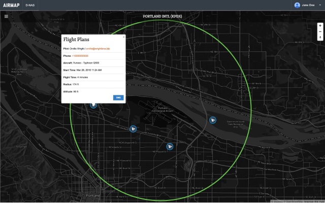
AirMap, a provider of airspace information and services for unmanned aircraft, and the American Association of Airport Executives (AAAE), through the Airport Innovation Accelerator, have announced the release of the Digital Notice and Awareness System (D-NAS). D-NAS was created to allow UAS operators to provide airports with real-time digital information about the location of their flights.

D-NAS works by allowing a UAS operator to send an encrypted digital flight notice to a secure dashboard at an airport’s operations center. Flight information will be able to be submitted through many different UAS interfaces, including the flying apps provided by leading drone manufacturers DJI, Yuneec, and 3DRobotics. These connections facilitate the transmission of important safety-critical information to airports, including the GPS location of the UAS flight. Participating airports will access this information through the AirMap D-NAS dashboard, which provides a map view of flights in proximity to the airport and the option to contact the UAS operator directly.

“Safety has always been a priority for DJI,” said Brendan Schulman, DJI’s Vice President of Policy and Legal Affairs. “Providing our customers the capability to easily notify nearby airports of their flights is a huge step forward in convenience and functionality. A high-tech notification system complements the safety features DJI builds into every drone, as well as DJI’s close work with policymakers on practical approaches for drone technology.”

Yuneec CEO Tian Yu explained, “We are excited to work with AirMap to improve the safety features of our products. As an airplane and helicopter pilot myself, I know first-hand how important it is to keep the national airspace system safe.” Yuneec is the manufacturer of the popular Typhoon and Tornado series of multirotor drones and recently announced a $60M investment from Intel.

More than 50 airports across America have already joined the D-NAS pilot program, including Houston’s George Bush Intercontinental and William P. Hobby airports, Denver International Airport, Columbus Air Force Base in Mississippi, Charlotte-Douglas Airport in North Carolina, Reno-Tahoe Airport in Nevada, New Castle Airport in Delaware, Cape May Airport in New Jersey, Fairbanks International Airport in Alaska, and the Oxnard and Camarillo Airports in Ventura County, California.

“Participation in the D-NAS pilot was a no-brainer for us. In the face of growing concerns over UAS operations near airports, AirMap has developed an effective and unique solution,” said Steve Runge, Division Manager for the Houston Airport System. “D-NAS is a game changer for how we will manage low altitude air safety.”

D-NAS not only provides heightened awareness to airports; it also makes it easy for UAS operators to comply with Section 336 of the FAA Modernization and Reform Act of 2012, which requires notice to be given to airports within five miles of a drone’s flight location.

Ben Marcus, CEO of AirMap and an airline transport rated pilot and flight instructor, said, “Everyone involved in aviation sees the promise and potential of unmanned aircraft. However, we can’t reach the potential of this amazing technology unless we ensure that safety critical information keeps pace with innovation. We are focused on building the tools for unmanned aircraft to safely integrate into the national airspace system.”

Read more…

Changes to Australian RPA Legislation

3689686217?profile=original

The Australian Government has recently registered an amendment to the Civil Aviation Legislation Amendment (Part 101) - concerning the regulations of Remotely Piloted Vehicles (RPA's).

Some of the more interesting changes are:

4 classes of RPA, based on all-up-weight:

  • Micro RPA (0-100g)
  • Very Small RPA (100g-2kg)
  • Small RPA (2kg-25kg)
  • Medium RPA (25kg-150kg)

Commercial Operation

No training or licences required to operate Micro and Very Small RPA's commercially in standard flight conditions. However, CASA does have to be notified 5 working days beforehand.

Operation over Private Land

Small RPA's and below can operated over private land (the landowner/occupier must own the RPA) in standard flight conditions without requiring any licences or training.

Licensing

New “Remote Pilot Licenses” to replace UAV Controller Certificate.

Standard Flight Conditions

Standard (not needing an exemption from CASA) conditions have been tweaked slightly to:

  • Under 400ft AGL
  • Outside of 30m from other people
  • Not over a populous area
  • Not within 3nm of an airport
  • Not in a restricted or prohibited area
  • Not over an area where public safety or emergency operations are being conducted (without their prior permission)
  • Is within visual line of sight by the operator

The full changes to the legislation are available at https://www.legislation.gov.au/Details/F2016L00400

EDIT:

Note this legislation does not come into effect until 1 October 2016

Read more…
3D Robotics

3689421694?profile=originalFrom the FAA press release:

March 29- After a comprehensive risk analysis, the Federal Aviation Administration (FAA) has raised the unmanned aircraft (UAS) “blanket” altitude authorization for Section 333 exemption holders and government aircraft operators to 400 feet. Previously, the agency had put in place a nationwide Certificate of Waiver or Authorization (COA) for such flights up to 200 feet.

The new COA policy allows small unmanned aircraft—operated as other than model aircraft (i.e. commercial use)—to fly up to 400 feet anywhere in the country except restricted airspace and other areas, such as major cities, where the agency prohibits UAS operations.

“This is another milestone in our effort to change the traditional speed of government,” said FAA Administrator Michael Huerta. “Expanding the authorized airspace for these operations means government and industry can carry out unmanned aircraft missions more quickly and with less red tape.”

The FAA expects the move will reduce the workload for COA applications for industry UAS operators, government agencies and the FAA's Air Traffic Organization. The agency also estimates the move will lessen the need for individual COAs by 30 to 40 percent. Other provisions of an FAA authorization, such as registering the UAS and making sure pilots have the proper certification, still apply.

Under the blanket COA, the FAA will permit flights at or below 400 feet for UAS operators with a Section 333 exemption for aircraft weighing less than 55 pounds and for government UAS operations. Operators must fly under daytime Visual Flight Rules, keep the UAS within visual line of sight of the pilot and stay certain distances away from airports or heliports:

  • Five nautical miles (NM) from an airport having an operational control tower; or
  • Three NM from an airport with a published instrument flight procedure, but not an operational tower; or
  • Two NM from an airport without a published instrument flight procedure or an operational tower; or
  • Two NM from a heliport with a published instrument flight procedure.

Read more…

3689685798?profile=original

After receiving an interesting request for drone usage from Japan, we decided to share it with you.

Oftentimes even before starting the construction of a building, the company needs to make the idea gain interest and acquire orders from potential customers. While the inside view of the apartments can be rendered in CAD, to illustrate the view from windows it makes a lot more sense to actually take the pictures instead of rendering them.

To take photos of the view from windows / balcony of apartments of buildings which are yet to be built, a drone with an automatic camera trigger can be used. 

The first image of the post is the sketch of the idea by Keitaro Sugiyama.

This idea can be easily brought to life by using UgCS ground station for flight planning. This is how the flight plan would look in UgCS:

3689685915?profile=original

The creation of this route took only about 30 minutes using the distance measurement tool in UgCS and calculating all the exact locations and placing the waypoints along with camera trigger actions. However, after a 5 minute flight you will get excellent and accurate marketing material for potential clients.

Get UgCS here: www.ugcs.com


Safe flights,
UgCS Team


Read more…

Chris Anderson is one of the keynote speakers at the upcoming Drones, Data X Conference, on June 3rd in San Francisco. A lineup of speakers from companies such as 

montage_600x343.png

Tobin Fisher, CEO Vantage Robotics

Remi El-Ouazzne, CEO Movidius

Michael Droback, CEO Small UAV Coalition

Christian Sanz, CEO Skycatch

Ben Marcus, CEO AirMap

Mike Winn, CEO DroneDeploy

Jay Bregman, CEO Verifly

Buddy Michini, CTO Airware

Chris Blackford, COO Sky Futures

Companies represented at the event are from RedBird, Microsoft, Sony, Orange Labs, Yamaha, Jabil, Bolt, NTT DoCoMo and many more. 

Tickets are on sale now. For any members of DIY Drones, we will be offering tickets at $199 (Normally $250) by using the code DRONES20 for the next couple of weeks. http://buytickets.at/nua/45464/r/diydrone

Read more…
Developer

New ArduPilot.org Discussion Forums Online

3689685852?profile=original

Many of you have been wondering the future of the ArduPilot project (RE: A New Chapter) The wait is finally over and we are happy to release our shiny new services for you all.

Wait is finally over :)

Most of developers have been really quiet last weeks. This is because there have been a great amount of work being done behind the scenes to make sure everything continues working as smooth as possible. Work like restructuring of the whole document site, new servers being set up, auto testers and firmware repositories have been moved along with whole firmware repositories and finally tens of thousands of posts and thousands of users from old the forums to a new discourse discussion servers and many more things. Sure there are still things to do but the major work is finished now and this is a great new beginning for the future ArduPilot development.

I am happy to invite all new and old members to come and join us on our new website: ArduPilot.org

Site changes are as follows:

- The ArduPilot groups and support forums have been combined and are now located at http://discuss.ardupilot.org

- The old support forums are archived at forums.ardupilot.org

- The wiki is located at http://ardupilot.org/ardupilot/index.html

As for the continuity, Tridge has already mentioned on his post here, new entities have been created and there are already several financial entities supporting this project and more are coming. After all admin work is done there will be more details about that.

I would like to offer my deepest gratitude for Bill, Buzz, Craig, Gary, Hamish, Tom and many others from ArduPilot team for the help to get all the work done.

With best regards,

The ArduPilot Dev Team

Read more…
3D Robotics

3689685759?profile=original

A new report from the US FAA predicts that UAVs will be "the most dynamic sector in aviation". From the press release:

A key portion of the forecast focuses on projections for the growth in the use of unmanned aircraft, also known as drones. The FAA estimates small, hobbyist UAS purchases may grow from 1.9 million in 2016 to as many as 4.3 million by 2020.  Sales of UAS for commercial purposes are expected to grow from 600,000 in 2016 to 2.7 million by 2020.  Combined total hobbyist and commercial UAS sales are expected to rise from 2.5 million in 2016 to 7 million in 2020.

Predictions for small UAS used in the commercial fleet are more difficult to develop given the dynamic, quickly-evolving nature of the market. Both sales and fleet size estimates share certain broad assumptions about operating limitations for small UAS during the next five years: daytime operations, within visual line of sight, and a single pilot operating only one small UAS at a time.  The main difference in the high and low end of the forecasts is differing views on how those limitations will influence the widespread use of UAS for commercial purposes.

3689685776?profile=original

(I only wish they knew how to make a stacked bar graph -- see the abomination at top)

Read more…
MR60


Hi, I bought these very cheap hobbyking rectangular carbon tubes. I made this not so serious experiment with them as they could potentially be great to build your own multicopter frames. Tridge, by the way, used those recently in his quadplane build he posted about on diydrones.

And, this is a not so serious contribution to coming Easter chickens...

Enjoy Easter everyone!

Hugues

Read more…
Developer

APM:Plane 3.5.2 released

3689651507?profile=originalThe ArduPilot development team is proud to announce the release of version 3.5.2 of APM:Plane. This is a minor release with small changes.

The main reason for this release over the recent 3.5.1 release is a fix for a bug where the px4io co-processor on a Pixhawk can run out of memory while booting. This causes the board to be unresponsive on boot. It only happens if you have a more complex servo setup and is caused by too much memory used by the IO failsafe mixer.

The second motivation for this release is to fix an issue where during a geofence altitude failsafe that happens at low speed an aircraft may dive much further than it should to gain speed. This only happened if the thrust line of the aircraft combined with low pitch integrator gain led to the aircraft not compensating sufficiently with elevator at full throttle in a TECS underspeed state. To fix this two changes have been made:

  • a minimum level of integrator in the pitch controller has been added. This level has a sufficiently small time constant to avoid the problem with the TECS controller in an underspeed state.
  • the underspeed state in TECS has been modified so that underspeed can end before the full target altitude has been reached, as long as the airspeed has risen sufficiently past the minimum airspeed for a sufficient period of time (by 15% above minimum airspeed for 3 seconds).

Many thanks to Marc Merlin for reporting this bug!

The default P gains for both roll and pitch have also been raised from 0.4 to 0.6. This is to help for users that fly with the default parameters. A value of 0.6 is safe for all aircraft that I have analysed logs for.

The default gains and filter frequencies of the QuadPlane code have also been adjusted to better reflect the types of aircraft users have been building.

Other changes include:

  • improved QuadPlane logging for better analysis and tuning (adding RATE and QTUN messages)
  • fixed a bug introduced in 3.5.1 in rangefinder landing
  • added TECS logging of speed_weight and flags
  • improvements to the lsm303d driver for Linux
  • improvements to the waf build system


Happy flying!

Read more…

3689685751?profile=original

This is not about a promotion of some manufacturer, or shop, or me, this is about you!!

A fellow hobbyist/maker and an opportunity to breathe life into your creation.


   There's not going to be any fancy graphic banners or profit promises, rather, what you see/read if won enough votes is what you get and all you got to do to enter the contest is to post any of your own wildest dream CAD project drawings/renders. No more nor less!

   Preferably frame image/render in perspective, not the actual design top view of the design as intent is only to present your idea to the contest followers so they can decide which frame they want to vote for based on your design presentation. No need for fancy renders or drawings, present your work in the best light you can.

The prize is a 125$ prototyping fund for your creation if you won the most votes.

   To ensure that the prize prototyping funds are going for that exact purpose, I've decided that the amount will be credited to your account on the reliable, thrust worthy and high quality production service I have had great prototyping experience with, The Armattan Productions.

With this I hope I'll get to help a fellow hobbyist/maker to get an actual prototype of his creation in his hands and have some fun ;)

   I've been there and was lucky enough to get supported by some amazing folks thanks to which my creation came to life. I cannot Thank them enough for it and having an opportunity to do something similar for a fellow hobbyist/maker, it just doesn't get any better than that!


    This will be posted on almost all forums I'm a member of in the Pilot/Scratch build sections with hope it will attract the most hobbyists. The central design contest thread in which all designs will be finally shown and presented for voting when it's time: http://www.rcgroups.com/forums/showthread.php?t=2628451#post34306551

 If you got a friend who's working on a design, tell him about this opportunity!

  The contest will go on for 2 months starting of today after which the vote pool will be closed and the winner will be announced!

Enough talk ;)

So, you got a design you are working on?


Something you would like to share and get some feedback on?

No need to look any further, post your design and let the contest begin!

Get the most votes and Win a 125$ worth prototyping fund.

Good luck! :D

Read more…

An interesting addition to the fpv world, a small lens mounted monocular monitor connectible to most fpv receivers. But the quality and useablility? Time will tell.

Description:
Dimensions: 15.2*11.3*9.2mm , Net Weight:<15g

Specification:
Virtual Size: 78 inches screen (Fictitous distance 2 meters)
Resolution: VGA 640X480
Video Input: Simulation CVBS
Viewing Angle: 26°
Operating Voltage: DC3.5V-5V
Operating Current: <120mA
Power consumption: <0.6w

Package Included:
1 x Monocular Display
2 x Ocular
1 x Video  Wire
1 x Manual

Product Link here

Read more…

3689685678?profile=original
It's always rewarding to see our users using UgCS and being satisfied with the product we offer.

Our user Chani from Sweden shared this video with us of him using UgCS together with Pix4D to scan an area with DJI Naza-M V2. After the images taken during the flight were geotagged in UgCS, they were used to create a 3D model of the area in Pix4D and do volume calculations.

Here's the video: 


You can download the newest version of UgCS here: www.ugcs.com

Read more…

3689685577?profile=original

Recently published peer-reviewed scientific article:

Aerial imagery captured via unmanned aerial vehicles (UAVs) is playing an increasingly important role in disaster response. Unlike satellite imagery, aerial imagery can be captured and processed within hours rather than days. In addition, the spatial resolution of aerial imagery is an order of magnitude higher than the imagery produced by the most sophisticated commercial satellites today. Both the United States Federal Emergency Management Agency (FEMA) and the European Commission's Joint Research Center (JRC) have noted that aerial imagery will inevitably present a big data challenge.

The purpose of this article is to get ahead of this future challenge by proposing a hybrid crowdsourcing and real-time machine learning solution to rapidly process large volumes of aerial data for disaster response in a time-sensitive manner. Crowdsourcing can be used to annotate features of interest in aerial images (such as damaged shelters and roads blocked by debris). These human-annotated features can then be used to train a supervised machine learning system to learn to recognize such features in new unseen images.

In this article, we describe how this hybrid solution for image analysis can be implemented as a module (i.e., Aerial Clicker) to extend an existing platform called Artificial Intelligence for Disaster Response (AIDR), which has already been deployed to classify microblog messages during disasters using its Text Clicker module and in response to Cyclone Pam, a category 5 cyclone that devastated Vanuatu in March 2015. The hybrid solution we present can be applied to both aerial and satellite imagery and has applications beyond disaster response such as wildlife protection, human rights, and archeological exploration.

As a proof of concept, we recently piloted this solution using very high-resolution aerial photographs of a wildlife reserve in Namibia to support rangers with their wildlife conservation efforts (SAVMAP project). The results suggest that the platform we have developed to combine crowdsourcing and machine learning to make sense of large volumes of aerial images can be used for disaster response.

http://online.liebertpub.com/doi/full/10.1089/big.2014.0064

Read more…

3689685590?profile=original

3D Robotics Inc., one of the better-funded, high-profile drone startups, is laying off an undisclosed number of its staff in a restructuring aimed at moving more quickly into the commercial market, due to heavy competition in the consumer drone market.

http://www.marketwatch.com/story/drone-maker-3d-robotics-reboots-by-cutting-jobs-refocusing-on-corporate-market-2016-03-23

Read more…