All Posts (11086)

Sort by
Developer

Rover Release 3.0.0 is OUT!

3689639585?profile=originalThe ArduPilot development team is proud to announce the release of version 3.0.0 of APM:Rover. This is a major release with a lot of changes so please read the notes carefully!

A huge thanks to ALL the ArduPilot developers.  The Rover code benefits tremendously from all the hard work that goes into the Copter and Plane vehicle code.  Most of the code changes in this release were not specifically for Rover however because of the fantastic architecture of the ArduPilot code Rover automatically get's those enhancements anyway.

Note that the documentation hasn't yet caught up with all the changes in this release. We are still working on that, but meanwhile if you see a feature that interests you and it isn't documented yet then please ask.

The 3.x.x releases and above DON'T support APM1/APM2
This release DOES NOT SUPPORT the old APM1/APM2 AVR based boards. The issue is the amount of effort required to keep the new code ported to the old platforms.  We are very sorry this has to occur and if there is someone who is willing and technically capable of doing this work then please let us know.

There will be a discussion created on ArduPilot forums where people can request features in the new code be backported to the APM code to run on the AVR boards and if it is reasonably easy and they are willing to do the beta testing we will do our best to make it happen.

EKF2 - New Kalman Filter
Paul Riseborough has been working hard recently on the new EKF2 variant which fixes many issues seen with the old estimator. The key improvements are:

  • support for separate filters on each IMU for multi-IMU boards (such as the Pixhawk), giving a high degree of redundancy
  • much better handling of gyro drift estimation, especially on start up
  • much faster recovery from attitude estimation errors


After extensive testing of the new EKF code we decided to make it the default for this release. You can still use the old EKF if you want to by setting AHRS_EKF_TYPE to 1, although it is recommended that the new EKF be used for all vehicles.

In order to use the EKF we need to be a bit more careful about the setup of the vehicle. That is why we enabled arming and pre-arm checks by default. Please don't disable the arming checks, they are there for very good reasons.

UAVCAN new protocol
The uavcan change to the new protocol has been a long time coming, and we'd like to thank Holger for both his great work on this and his patience given how long it has taken to be in a release. This adds support for automatic canbus node assignment which makes setup much easier, and also supports the latest versions of the Zubax canbus GPS.

Support for 4 new Boards
The porting of ArduPilot to more boards continues, with support for 3 new boards in this release. They are:

  • the BHAT board
  • the PXFmini
  • the QualComm Flight
  • the Pixracer


More information about the list of supported boards is available here:
http://dev.ardupilot.com/wiki/supported-autopilot-controller-boards/

Startup on a moving platform
One of the benefits of the new EKF2 estimator is that it allows for rapid estimation of gyro offset without doing a gyro calibration on startup. This makes it possible to startup and arm on a moving platform by setting the INS_GYR_CAL parameter to zero (to disable gyro calibration on boot). This should be a big help for boats.

Improved Camera Trigger Logging
This release adds new CAM_FEEDBACK_PIN and CAM_FEEDBACK_POL parameters. These add support for separate CAM and TRIG log messages, where TRIG is logged when the camera is triggered and the CAM message is logged when an external pin indicates the camera has actually fired. This pin is typically based on the flash hot shoe of a camera
and provides a way to log the exact time of camera triggering more accurately. Many thanks to Dario Andres and Jaime Machuca for their work on this feature.

PID Tuning
You can now see the individual contributions of the P, I and D components for the Steering PID in the logs (PIDY), allowing you to get a much better picture of the performance.

Vibration Logging
This release includes a lot more options for diagnosing vibration issues. You will notice new VIBRATION messages in MAVLink and VIBE messages in the dataflash logs. Those give you a good idea of your (unfiltered) vibration levels. For really detailed analysis you can setup your LOG_BITMASK to include raw logging, which gives you every accel and gyro sample on your Pixhawk. You can then do a FFT on the result and plot the distribution of vibration level with frequency. That is great for finding the cause of vibration issues. Note that you need a very fast microSD card for that to work!

Steering Disarm
This is the first release that allows you to disarm using steering if you want to. It isn't enabled by default. You can enable it
with the ARMING_RUDDER parameter by setting it to 2. It will only allow you to disarm if the autopilot thinks you are not moving at the time.

More Sensors
This release includes support for a bunch more sensors. It now supports 3 different interfaces for the LightWare range of Lidars (serial, I2C and analog), and also supports the very nice Septentrio RTK dual-frequency GPS (the first dual-frequency GPS we have support for). It also supports the new "blue label" Lidar from Pulsed Light (both on I2C and PWM).

For the uBlox GPS, we now have a lot more configurability of the driver, with the ability to set the GNSS mode for different constellations. Also in the uBlox driver we support logging of the raw carrier phase and pseudo range data, which allows for post RTK analysis with raw-capable receivers for really accurate photo missions.

Better Linux support
This release includes a lot of improvements to the Linux based autopilot boards, including the NavIO+, the PXF and ERLE boards and the BBBMini and the new RasPilot board.

On-board compass calibrator
We also have a new on-board compass calibrator, which also adds calibration for soft iron effects, allowing for much more accurate compass calibration.

Lots of other changes!
The above list is just a taste of the changes that have gone into this release. Thousands of small changes have gone into this release with dozens of people contributing. Many thanks to everyone who helped!

Other key changes

  • fixed the MAV_CMD_DO_SET_HOME (thanks salonijain12)
  • fixed bug when reverse throttle would increase speed in AUTO
  • fixed a bug going into guided and rover still moving
  • loitering at a waypoint if Param1 is non-zero
  • update uavcan to new protocol
  • fixed reporting of armed state with safety switch
  • added optional arming check for minimum voltage
  • improved text message queueing to ground stations
  • re-organisation of HAL_Linux bus API
  • improved NMEA parsing in GPS driver
  • improved autoconfig of uBlox GPS driver
  • support a wider range of Lightware serial Lidars
  • improved non-GPS performance of EKF2
  • improved compass fusion in EKF2
  • improved support for Pixracer board
  • improved NavIO2 support
  • added BATT_WATT_MAX parameter
  • enable messages for MAVLink gimbal support
  • use 64 bit timestamps in dataflash logs
  • added realtime PID tuning messages and PID logging
  • fixed a failure case for the px4 failsafe mixer
  • added DSM binding support on Pixhawk
  • added vibration level logging
  • ignore low voltage failsafe while disarmed
  • added delta velocity and delta angle logging
  • allow steering disarm based on ARMING_RUDDER parameter
  • prevent mode switch changes changing WP tracking
  • fixed parameter documentation spelling errors
  • send MISSION_ITEM_REACHED messages on waypoint completion
  • enable EKF by default on rover
  • Improve gyro bias learning rate for plane and rover
  • Allow switching primary GPS instance with 1 sat difference
  • added NSH over MAVLink support
  • added support for mpu9250 on pixhawk and pixhawk2
  • Add support for logging ublox RXM-RAWX messages
  • lots of updates to improve support for Linux based boards
  • added ORGN message in dataflash
  • added support for new "blue label" Lidar
  • switched to real hdop in uBlox driver
  • improved auto-config of uBlox
  • raise accel discrepancy arming threshold to 0.75
  • improved support for tcp and udp connections on Linux
  • switched to delta-velocity and delta-angles in DCM
  • improved detection of which accel to use in EKF
  • improved auto-detections of flow control on pixhawk UARTs
  • added HDOP to uavcan GPS driver
  • improved sending of autopilot version
  • log zero rangefinder distance when unhealthy
  • added PRU firmware files for BeagleBoneBlack port
  • fix for recent STORM32 gimbal support
  • changed sending of STATUSTEXT severity to use correct values
  • added new RSSI library with PWM input support
  • fixed MAVLink heading report for UAVCAN GPS
  • support LightWare I2C rangefinder on Linux
  • improved staging of parameters and formats on startup to dataflash
  • added new on-board compass calibrator
  • improved RCOutput code for NavIO port
  • added support for Septentrio GPS receiver
  • support DO_MOUNT_CONTROl via command-long interface
  • added CAM_RELAY_ON parameter
  • moved SKIP_GYRO_CAL functionality to INS_GYR_CAL
  • new waf build system
  • new async accel calibrator
  • better rangefinder power control
  • dataflash over mavlink support
  • settable main loop rate
  • hideable parameters
  • improved logging for dual-GPS setups
  • improvements to multiple RTK GPS drivers
  • numerous HAL_Linux improvements
  • improved logging of CAM messages
  • added support for IMU heaters in HAL_Linux
  • support for RCInput over UDP in HAL_Linux
  • improved EKF startup checks for GPS accuracy
  • added raw IMU logging for all platforms
  • configurable RGB LED brightness
  • improvements to the lsm303d driver for Linux

Read more…

A.M.A. RC meeting in Mar del Plata, Argentine

Past weekend was the annual RC meeting in Mar del Plata, Argentine at A.M.A. (Agrupacion Marplatense de Aeromodelismo (not USA AMA)) :People from the whole country visit us annually in April with their models, Acrobatics, scale, Drones, Helicopters, Glow, manned and anything that flies.

Read more…
3D Robotics

The new Viooa smart-camera combines 360-degree optics with an on-board Nvidia processor to add some pretty amazing functionality to Solo. 

3689687188?profile=original

TECHNICAL SPECIFICATIONS

The Inevitable Smart Camera Evolution

Size and Weight:

Dimension
  • ∞ Camera: 133mmX118mmX50mm / 5.2”X4.6”X2”
  • ∞ Adapter: 85mmX75mmX27mm / 3.3”X3”X1”
Weight
  • ∞ Camera: 176g
  • ∞ Adapter: 110g
  • ∞ Optional impact and scratches-resistant cover: 12g
Temperature
∞ From -20° to 50°C / From -4° to 122°F

Recording:

Video Mode
  • ∞ UHD-4K 3864 X 2160 30fps
  • ∞ 2K 2048 X 1080 30fps
  • ∞ HD 1080p 1920X1080 60fps
  • ∞ HD 720p 1280X720 60fps
  • ∞ SVGA 800X600 60fps
Video File Formats
∞ MP4 / H.264
Photo Mode
∞ 8.5 Megapixel 3864 X 2202
Photo Mode
∞ JPG / RAW
Audio Format
∞ Mono, 48 kHz, 64 kbps AAC

Viewers:

Computer
∞ Mac OS X, Windows players
Online
∞ YouTube and Facebook 360° video players
Smartphone and Tablet
∞ Windows, Android, and iOS
Virtual Reality (VR)
∞ Oculus Rift, Samsung Gear, FatShark, Zeiss, and more

Supported Platforms:

Multirotors
∞ Phantom 1, Phantom 2, Phantom 3, Inspire 1, S900, S1000+, Matric 100, Solo, Iris, X8, Yuneec, A2, WooKong-M, Naza-M, Pixhawk, APM, Walkera, custom-built, and more
Fixed-wing
∞ Quest UAV, Lehmann, UAV Factory, X8 platform, custom-built, and more

Optic/Lens:

Field of View
∞ 360° X 180°
Number of Cameras
∞ 3
Sensor Technologies
∞ Fully synchronized Global Release technology with constant exposure, white balance, and image enhancement

Features:

Stitching
∞ Real-time, onboard
GPS
∞ High precision GNSS < 1m, 56-channels, GPS/QZSS and GLONASS
Image Enhancement
∞ Gyroscopic/accelerometer sensors and image processing algorithms for camera orientation and stabilization
RC Receiver / Autopilot
∞ S.BUS and CAN-Bus inputs
USB
∞ MicroUSB 3.0 for updates and image/footage downloading
Bluetooth
∞ Bluetooth 4.0 to interface with the camera’s settings
Microphone
∞ Built-in microphone
Storage
∞ MicroSD up to 256GB card for full 360° or snapshot coverage recording
HDMI Video Output
∞ Lightbridge, Connex, Teradek, and more
Analog Video Output
∞ FatShark, HobbyKing, ImmersionRC, Boscam, and more
RC receiver
∞ Supports Futaba, Spektrum, JETI, and more
Autopilots
∞ Supports DJI, 3DR, Airware, MicroPilot, Paparazzi, and more

Power:

Power Source
∞ Supports input LiPo 3S-6S (11.1v-22.2V)

Modes:

Live
∞ Real time point-of-Interest (POI) output, recording 360° footage
First Person View (FPV)
∞ Real time point-of-Interest (POI) output , recording 360° footage – image orientation is disabled
Mosaic
∞ Leveled geotagged snapshot triggered by time/distance or by autopilot
Read more…

For most modern drone applications, it becomes important to implement custom flight modes, such as, follow-me, orbit, cable-cam, selfie, and so on. These modes help automate several drone functions to allow the operator better focus on the key task at hand.

However, these custom flight-modes have so far been available only on ready-to-fly drones, which are pre-configured, tightly-coupled with the drone hardware, and do not allow DIY folks to reconfigure/tweak or introduce new modes, based on their requirements. FlytOS now makes it quite simple for DIY community to implement a variety of such modes (including, advanced stuff, such as, computer vision, swarms, cloud-connectivity, mobile/web app integration). 

This demo shows an implementation of the "follow-me" mode on a custom drone. A custom user-interface has been exposed on an android app, which can be used to view the location of drone on google-map, get live video feed (onboard camera), and adjust the position of the drone relative to the person being followed. The user-interface can easily be made available as a web-app, or an iOS app, as well.

The source code for this custom app is available here: https://github.com/flytbase/flytsamples/tree/master/AndroidApps/FlytFollowMe

To download FlytOS and start implementing you own custom flight-modes, visit: http://flytbase.com/flytos/

Documentation for FlytOS is available at: http://docs.flytbase.com

Read more…

MicroPilot support in UgCS

3689686980?profile=original

UgCS by SPH Engineering is now compatible with autopilots made by MicroPilot Inc., including helicopter and multirotor autopilots.


April 5, 2016 – SPH Engineering and MicroPilot Inc. are pleased to announce that the UgCS ground control station software is now compatible with MicroPilot’s line of helicopter and multirotor autopilots. Fixed wing support will be coming soon.


UgCS supports Click-and-Go functionality, waypoint actions, live video streaming and recording; replaying the flight in telemetry player, and importing 3D buildings and terrain profiles. All of these features of UgCS are available for users of MicroPilot autopilots. Furthermore, UgCS supports joystick payload control with MicroPilot-equipped drones.


MicroPilot autopilots are compact, ultra light-weight autopilots that can fly anything from multirotors, to helicopters to fixed wing aircraft. The autopilot models range from the entry level MP1028g2 autopilot, to the triple redundant MP21283X autopilot.


Both MicroPilot Inc. and SPH Engineering are pleased to be working together. President of MicroPilot, Howard Loewen, said: “We are pleased that UgCS is now available for use with MicroPilot autopilots. UgCS gives MicroPilot’s customers more choice for GCS software, allowing them to better serve their end users.” Out of the box, the current version of UgCS is, with the Pro license, compatible with MicroPilot autopilots. As Janis Kuze, the sales director of SPH Engineering said “We are always excited to forge partnerships with other companies working in the UAV field. Working with Micropilot and their advanced autopilots has helped us bring UgCS to the next level by making it available for use with more sophisticated systems.”


For more information please contact SPH Engineering or MicroPilot.

UgCS can be downloaded here: www.ugcs.com

About MicroPilot

Started in 1994, with 850 clients in over 70 countries, MicroPilot is the world leader in professional autopilots for UAVs and MAVs. MicroPilot is an ISO 9001 autopilot manufacturer to bring to market an ISO 9001 sub 30 gram autopilot, triple redundant autopilot, and full-function general purpose autopilot. MicroPilot offers a family of lightweight UAV autopilots that can fly fixed-wing, transitional, helicopter, and Multi Rotor UAVs. MicroPilot also provides complementary products such as the XTENDERmp SDK, trueHWIL2.


About UgCS

SPH Engineering creates easy-to-use software for mission planning and execution for all types of unmanned aerial and land vehicles. SPH Engineering is a hard driven team of flight enthusiasts and adventurers. Some can actually make high quality robots and 3D printers. There is no such thing as too good! SPH Engineering continuously follows the latest industry news, learns more about its clients needs and develops its products. SPH Engineering is doing its best to bring you the best. Everyone at SPH Engineering loves, what they do and there is a reason - their technology is not just a product… It's their passion.


SPH Enginnering is proud to inform you that it is continuously improving their cooperation and creating new partnerships. Their mission is not just providing you with their products, but also genuinely sharing their knowledge and experience.


Read more…

Reach RTK Pixhawk integration released!

precisionlanding.gif

This landing looks so good like it is a reversed takeoff video. In reality this is a demonstration of using Reach RTK integrated with Pixhawk. This feature is now available for all ArduPilot based autopilots, including our beloved Navio+ and Navio2.


Only single radio has been used, with RTCM3 corrections tunneled through telemetry and Pixhawk. As Reach is equipped with Wi-Fi it is easy to connect to it and use Mission Planner to inject correction data into the MAVLink stream.

3689687054?profile=original

We got several requests from the ArduPilot developers not to use NMEA protocol for this integration as it does not carry all required data. GPS gives autopilot more than just location data. Speed, accuracy estimates, heading and more is required for ArduPilot to take full advantage of an RTK GPS. This is why we have added custom ERB (Emlid Reach Binary) protocol. For other autopilot systems NMEA output is available as well.


In this test flight we used ArduCopter 3.3.3-Reach, it is stable firmware with ERB protocol support added on top. We will provide custom builds for now, but considering that this code is already in master we expect to see full Reach RTK support in ArduCopter 3.4 . If you would like to build your own firmware, here is the related pull-request.


We have put together detailed docs about this integration that cover Pixhawk, Radio and Reach settings as well as Mission Planner GPS inject feature.

Reach users will need to perform an update through ReachView app. ArduPilot integration is available in version 0.3.0 or higher.  


PI70MGAblbc0Mn9IpKUYzBoefFWHQRC6OsYIcaP5N0aB9m0tnnuCONJQW905f4d_MlOIO2StxBne3lGtzCJGEED8ZEJfr4wy-Rk4Cl61WmgMfCG587-4U88oAzPW1HVkq6JhvhyK?width=624


All settings, status and logs are accessible through our user-friendly ReachView web app. It works on any device that has a browser. The app is hosted on Reach itself thus does not require internet connection to work. You can connect Reach to the internet for updates and NTRIP corrections.

3689686966?profile=original

Only four months since we have shipped first units to our Indiegogo backers and development is moving forward at a great speed! During this time we have been working restlessly adding new features, improving stability and overall user experience with Reach. This release brings an amazing feature - integration with ArduPilot based autopilots. New features also include Bluetooth solution output, which allows to output enhanced coordinates to a number of Android apps, automatic log conversion to RINEX and many more.

Best regards,

Emlid Team

emlid.com

P.S. You can also read an incredible report by Luke Wijnberg about using Reach for placing Ground Control Points for mapping and general surveying. 

Read more…

Researchers at the Johns Hopkins University Applied Physics Laboratory in Laurel, Maryland, have developed an innovative unmanned aerial vehicle (UAV) that can stay on station beneath the water, then launch into the air to perform a variety of missions.

Picture of CRACUN
Picture of CRACUN 
Picture of CRACUN
The Corrosion Resistant Aerial Covert Unmanned Nautical System — or CRACUNS — is a submersible UAV that can be launched from a fixed position underwater, or from an unmanned underwater vehicle (UUV). 
Credit: Johns Hopkins APL

The Corrosion Resistant Aerial Covert Unmanned Nautical System — or CRACUNS — is a submersible UAV that can be launched from a fixed position underwater, or from an unmanned underwater vehicle (UUV). A team from APL’s Force Projection Sector worked with fabrication experts in the Research and Exploratory Development Department to create a new type of unmanned vehicle that can operate effectively in two very different arenas: air and water.

“Engineers at APL have long worked on both Navy submarine systems and autonomous UAVs,” said Jason Stipes of APL’s Sea Control Mission Area, project manager for CRACUNS. “In response to evolving sponsor challenges, we were inspired to develop a vehicle that could operate both underwater and in the air.” The resulting CRACUNS prototype system was developed and tested using internal research and development funding.

CRACUNS enables new capabilities not possible with existing UAV or UUV platforms. Its ability to operate in the harsh littoral (shore) environment, as well as its payload flexibility, enables a wide array of potential missions.

The most innovative feature of CRACUNS is that it can remain at and launch from a significant depth without needing structural metal parts or machined surfaces.

To make that possible, the team needed to overcome two big challenges. First, the APL team leveraged advances in additive manufacturing and novel fabrication techniques available at the Laboratory’s extensive fabrication facilities. The team fabricated a lightweight, submersible, composite airframe able to withstand the water pressure experienced while submerged.

The second significant challenge was to ensure CRACUNS could not just survive, but operate effectively in a corrosive saltwater environment. To do that, the APL team sealed the most sensitive components in a dry pressure vessel. For the motors that are exposed to salt water, APL applied commercially available protective coatings. The team tested the performance of the motors by submerging them in salt water. Two months later, they showed no sign of corrosion and continued to operate while submerged.

“CRACUNS successfully demonstrated a new way of thinking about the fabrication and use of unmanned systems,” said APL’s Rich Hooks, an aerospace and mechanical engineer who was responsible for the novel additive manufacturing techniques used on CRACUNS.

CRACUNS gives sponsors and researchers access to possibilities that were previously unavailable. CRACUNS’ low cost makes it expendable, allowing for the use of large numbers of vehicles for high-risk scenarios.

“APL’s culture of innovation and mission-ready solutions continues to deliver success for our sponsors,” said Sea Control Mission Area Executive Christopher Watkins.

Media contact: Geoff Brown, 240-228-5618, geoffrey.brown@jhuapl.edu

The Applied Physics Laboratory, a not-for-profit division of The Johns Hopkins University, meets critical national challenges through the innovative application of science and technology. For more information, visit www.jhuapl.edu.

taken from here

Read more…
3D Robotics

3689686929?profile=original

Last week the leading drone manufacturers announced we were leaving the Small UAV Coalition, which was a great start to our regulatory efforts but was not 100% focused on near-term commercial and consumer drone opportunities. Today we reveal what we're doing instead. From the announcement:

Leading global drone manufacturers 3DR, DJI, GoPro and Parrot today are forming the Drone Manufacturers Alliance, a coalition that will serve as the voice for drone manufacturers and our customers across civilian, governmental, recreational, commercial, nonprofit and public safety applications. We will advocate for policies that promote innovation and safety, and create a practical and responsible regulatory framework.

There are significant economic and social benefits to drone operations in the U.S., and industry must work with policymakers to ensure a safe environment for flying. The Drone Manufacturers Alliance believes a carefully balanced regulatory framework requires input from all stakeholders and must recognize the value and necessity of continued technological innovation. By highlighting innovation and emphasizing education, we intend to work with policymakers to ensure drones continue to be safely integrated into the national airspace.

###

Media Contact:

Rob Haralson for the Drone Manufacturers Alliance
rharalson@franklinsquaregroup.com
(202) 251-3322

Read more…
3D Robotics

From USA Today:

Carry cargo that's of live-saving importance, fly long-range fixed-wing aircraft in uncongested skies, and score a government as your first client?

That's the atypical approach being taken by Zipline, a Bay Area startup that has raised $18 million in funding from the likes of Yahoo founder Jerry Yang, Microsoft co-founder Paul Allen and others.

Companies such as Amazon and DHL are testing four-propeller helicopter (or quadcopter) drones for consumer goods deliveries in first world countries as lawmakers debate regulations governing such craft. Zipline founder Keller Rinaudo, in contrast, set his sights early on helping save African lives with a drone that looks like a small airplane.

"Getting medicine to remote places is both a huge market and a global challenge," says Rinaudo, 29, a Harvard-trained scientist who before starting Zipline in 2011 was a professional rock climber. "About half the cases the doctors we spoke with see are mothers hemorrhaging after child birth and 30% are kids with malaria. There's nothing more precious than blood and medicine."

Starting in July, Zipline, which came out of stealth mode Monday, will begin shuttling blood and other vital medical supplies via its 22-pound, battery-powered Zip aircraft to remote clinics throughout the central African nation of Rwanda. The planes can carry a payload of up to 3.5 pounds and have a roundtrip range of 75 miles, or about triple that of the average quadcopter.

Zip planes also can handle inclement weather much the way a traditional aircraft might, Rinaudo says, while quadcopters don't fare as well flying in stormy skies.

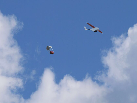
Most intriguingly, Zip planes drop their parachute-carrying payloads into predetermined landing zones, eliminating the need to land at the delivery site. Onboard computers compensate for wind to ensure accurate drops. The planes are launched via a high-powered catapult. The pre-programmed flights are monitored on the ground via tablets.

Typically, the rural Rwandan outposts served by Zipline are only reached a few times per year for resupply due largely to weather-ravaged road conditions, says Rinaudo. Zipline plans to have up to 150 flights per day, each one paid for by the Rwandan government.

Deliveries will consist largely of blood and small vials of medicine to Rwandan clinics, but eventually the payload is likely to broaden and service to other African nations will begin later this year.

While Rinaudo says he can envision demand for his service in Europe and the U.S., stringent aircraft regulations in those parts of the world makes those markets more difficult to navigate for drone delivery services. And first there's a small matter of making money.

"We're not a charity and we hope to reach profitability very quickly," he says.

Sequoia Capital partner Alfred Lin invested in the previous incarnation of Zipline, Romotive, which focused on toy robotics before pivoting to drone delivery. He says the Rwandan deal will allow Rinaudo and his team — who hail from companies such asSpaceX, Boeing and Google — to build a data-driven case for bringing the service to more densely populated areas.

Unlike quadcopter drones that lower their cargo to

Unlike quadcopter drones that lower their cargo to the ground, Zip drops its parachute-equipped payload from low heights. (Photo: Zipline)

"There's a broad ambition here with Zipline, one focused on using machines to better human lives," says Lin, who held top positions at Zappos before going into venture capital. "They're looking at applications that others in the space aren't focused on."

Last week, Zipline held a demonstration of its technology through an invite-onlyPeriscope broadcast. Rinaudo and his team, who are based south of San Francisco on the Pacific Coast but asked that their test facility not be disclosed, sent a Zip rocketing into grey skies with a mission to drop a payload along a nearby bluff.

Read more…
100KM

DeltaQuad VTOL autonomous maiden flight

After some succes with the QuadRanger we developed we decided to step it up and convert this Skywalker X8 to VTOL. And this was it's maiden (autonomous) flight

It was outfitted with the PX4 flightstack too which I recently added the VTOL_TAKEOFF and VTOL_LAND support.

The maiden flight of the DeltaQuad was a succes. It slightly overshot it's landing site due to a miscalibration of the airspeed sensor (it was flying faster then measured). Still it made for a very smooth flight.

In the next few weeks we will start payload and endurance testing, based on the current data it looks like it could carry a 1-2 kg payload for a distance of around 80km.

The build serves as a prototype for the modules/platforms that we (DronesLab) aim to produce and make available this year. 

I'm very interested in your thoughts, idea's and comments so feel free to drop a line! 

Read more…
Developer

suavc_logo_350.pngFrom USA Today article Drone coalition splits as DJI, GoPro faction quits.

SAN FRANCISCO — The national group that represents companies that make and sell drones has split, with those focused on consumers leaving to form their own organization.

Four drone companies left the Small UAV Coalition on Thursday. They are China-based DJI, French-based Parrot, San Mateo, Calif.-based GoPro and Berkeley, Calif.-based 3DR.

UAV stands for Unmanned Aerial Vehicle.

While still tightly aligned with the coalition on big issues, the break-away companies plan to create a still-unnamed group to very specifically focus on consumer issues, said GoPro spokesman Jeff Brown.

As the drone market matures, a shifting of needs was inevitable. Larger companies such as Amazon’s Prime Air, Alphabet’s Google X and others are looking more at drones for delivery, cargo and more commercial uses. Consumers have gravitated to using drones for photography, racing and just to play with.

“We think there are going to be millions of consumers that fly these, and that are focused on safe and responsible fight, and we want to make sure that the regulations track with them,” said Brown.

DJI and the other three companies all joined the Coalition about a year ago, "so it was a natural time to review where we were going,” said Adam Lisberg, spokesman for DJI Technology, the world’s largest drone manufacturer.

“We consider the Small UAV Coalition to be allies and friends. But the business is growing so big that we thought we would most benefit  from a group focused on the issues that are important to small drone manufacturers and our customers,” said Lisberg.

Many of the regulatory issues that surround drones are beginning to diverge, as the FAA makes a distinction between pleasure and commercial use. However the final outlines of what the rules will look like is still far from clear.

“The issues for our customers are about where and how average people can fly small drones,” Lisberg said.

The split was not unexpected and was very amicable, said Michael Drobac with the law firm of Akin Gump in Washington D.C. He is the spokesperson for the Small UAV Coalition.

“We wish them incredibly well in their work and we remain committed as a coalition to what we believe is going to be an incredibly vibrant commercial marketplace,” he said.

Read more…

 3689686762?profile=original

Hi all,

First of all, huge props to the devs on the Pixhawk firmware, and Mission/APM Planner -  We have a handful of multis and planes we fly and all run AP/AC with great success!


I run Propeller (www.propelleraero.com), and we let you deliver your drone data in an easy to use/share/measure web platform. Propeller began wanting to build drones, however our first customers were still looking for an easier way to manage the vast datasets we were collecting, and that has been the focus ever since.

Some of our standout features:

  • We accept geotagged source photos and GCPs as well as outputs you may have already generated in Pix4d/Agisoft. All processing performed on top tier Amazon servers, and GCPs placed by our professional remote sensing team. We are not a "black hole" online processing house.
  • Customised branding!

3689686646?profile=original

  • Full 3D in the browser and complex measurements: Volumetrics, change in volumetrics (between two different terrain surfaces), surface area, elevation changes across time.
  • GIS/CAD compatible downloads and exports. LAZ, DXF surface TIN, GeoTiff/JPEG. Measurements are exportable as DXF.
  • Oblique inspections: Perfect for cell towers, bridges, power transmission. Overlapping photos are stitched together into a street view style tool with annotations! Native imagery resolution remains intact, no orthorectifing.

3689686779?profile=original


Plans start at $50 per month and include the full feature set and branded portal, then pay as you upload data.


The platform is being developed with a strong industrial focus: Australia's three biggest aggregate producers and two biggest landfill operators use Propeller everyday to manage their sites, as well as some of the worlds largest mining  and construction companies, telecommunications and utility providers. We are building the platform for site managers and foreman rather than drone enthusiasts, in an attempt to bring this great new data to a wider, less technical audience.


If you are currently servicing the aggregate/mining, waste management, construction and asset inspection industries, register for a 7 day unlimited trial and upload some data today. https://app.prpellr.com/accounts/register/. When signing up, use the coupon DIYDRONES to get your first month free.

Regards,

Rory

Read more…
3D Robotics

3689686806?profile=original

AdaPilot is a new project to create a highly reliable open source autopilot using the Ada language. From the Project Overview:

AdaPilot, started in 2016, is a next-generation Open-Source software project with a reference hardware development kit, created by the AdaPilot Community. It has been designed from the ground up by a community of passionate Ada and ARM developers from around the globe, with its core design principles being quality, safety, and ease of use. It is aimed at providing a DO-178C certifiable safety critical flight control system composed of a single or redundant flight control computer with basic autopilot features, an attitude & heading reference system, a modular & customizable mission controller, a secure data-link, a electronic speed controller, a handheld ground control station and a mission management & planning software. The community can help to contribute to the AdaPilot code written in Ada-SPARK following the Core-Team advices and approvals. The reference hardware development kit forms the base for the AdaPilot environment, and through the use of the CANaerospace aviation bus protocol, the flexibility and integrability with third-party systems are only limited by the imagination and skills of the developers.

The current code base is targeting multirotors up to 8 rotors. However, the platform is flexible and can be adapted to fixed wing or single rotor, as well as for land-based and maritime applications.

Read more…
Moderator

Clash of the Titans, DJI sue Yuneec

clash-of-the-titans.jpg

DJI, the world’s leading maker of unmanned aerial vehicle (“UAV”) and camera technology, Friday filed a patent infringement lawsuit against Yuneec International Co. Ltd. and Yuneec USA, Inc. in the United States District Court for the Central District of California.

The complaint asserts that Yuneec’s products and technology infringe two DJI patents and seeks injunctive relief to halt the further sale of the infringing Yuneec products and systems.

DJI’s complaint alleges that Yuneec’s UAV products infringe one or more claims of DJI’s U.S. Patent Numbers 9,164,506, titled “Systems and methods for target tracking,” and 9,280,038, titled “Interchangeable Mounting Platform.”

DJI has invested a substantial amount of resources over the course of nearly a decade into the research and development of UAVs.  This investment has generated technology that is fundamental to the future of the UAV and related industrial applications.

DJI welcomes competition, but is committed to protecting its intellectual property. Friday’s filing is a response to safeguard that investment, to protect customers and partners and to promote genuine innovation in this promising area.

DJI holds hundreds of patents worldwide, including at least 30 issued in the U.S. and has at least 50 applications pending there. DJI offers state-of-the-art products and solutions for aerial photography, cinematography, remote tracking and monitoring, geological surveying, and many other commercial, personal, and industrial applications for professionals and hobbyists in the fields of journalism, filmmaking, emergency services, industrial equipment and road monitoring, and many others.

DJI is represented by the law firm of Wilson Sonsini Goodrich & Rosati, P.C.

Contact: Adam Lisberg, DJI North America Communications Director, adam.lisberg@dji.com

More comment and the full complaint here http://www.suasnews.com/2016/04/42799/

Read more…

InnoFlight announces Cerberus Triple Redundant Autopilot Systems

The advanced Jupiter JM-1 multicopter autopilot is now fully redundant with the release of the Cerberus Triple Redundant Autopilot Module by InnoFlight.

3689686684?profile=original

Taoyuan, Taiwan (R.O.C) – April, 2016

InnoFlight (INF), the leading manufacturer of flight control systems, UAV and stabilised camera gimbals in Taiwan today announced the release of the world first triple redundant Cerberus multicopter autopilot system. The company has over ten years’ experience in design and development of flight stabilised system for VTOL type aircrafts as well as over thirty years combined experienced in UAV operations.

“We are very excited to announce the release of the Cerberus Triple Redundant autopilot system. Cerberus enable up to 5 standard Jupiter JM-1 flight controller and theirs built-in IMU’s, GPS, and Compasses to work together as a true triple redundant flight control system.

The Cerberus redundant autopilot system not only provides the obvious increase in safety but when comparing to a single Jupiter JM-1, our triple redundant system can process sensor data from all three Jupiter JM-1 thus greatly increase the accuracy and performance of the system.

The Cerberus enhanced redundant system not only enables redundancy among autopilot modules as a whole but also their internal sensors. As long as two Main Control Units and sensors from any module are functioning, the Cerberus would continue to provide normal flight control operations.

To understand the benefit of a true triple redundant system we can look at this simple example; if the reliability of a typical autopilot is 1/1000, then the reliability of the same autopilot in a triple redundant arrangement would be 1/1000 x 1/1000 = 1/1,000,000. If the same system is multiplied up to a quadruple redundant system, then the reliability will go up to 1/1 billion and so forth.

In fact, our Cerberus redundant system CAN bus technology can support up to 5 Jupiter JM-1 giving you unprecedented reliability never seen before.”

INF is expected to begin shipping the Cerberus in July of 2016. Customers can see the Cerberus fully functional prototype on display at NAB, and AUVSI this April/May.

Read more…
Developer

With all the talk of integrating drones into civilian airspace, there is need for better safety and GPS-agnostic navigation methods - visual navigation and obstacle avoidance is paramount to integrating drones (micro-aerial-vehicles, MAVs) into our cities and elsewhere, because external navigation aids cannot be relied on in every situation, and neither can pilot experience.

Visual navigation is the solution to these challenges, and we present an aerial robot designed from scratch and ground up to meet these requirements. We demonstrate several facets of the system, including visual-inertial SLAM for state estimation, dense realtime volumetric mapping, obstacle avoidance and continuous path-planning.

In search of better extensibility, and better fitness for the research goals I had pitted myself towards, I started working as a part of the open-source PX4 Autopilot development community in 2013. Aware of the limitations in the field, I started Artemis, my research project on visual navigation for aerial vehicles in 2014. Today, I'm happy to present our intermediary (and satisfying!) results.

At its very core, Project Artemis is a research project which aims to provide improved navigation solutions for UAVs.

Screenshot-from-2016-03-18-071002.png?width=973

All of the Artemis MAVs follow the same basic, distributed  system architecture. There is a high-level onboard computer, and a low-level embedded flight controller, typically a PX4 autopilot board, or similar derivative. The middleware of choice on the high-level companion computer is ROS (Robot Operating System) and the PX4 Middleware on the deeply embedded controller.


Software

Visual Navigation

Multiple cameras provide proprioceptive information about the environment, used for mapping and localisation. Forward stereo cameras are used to compute depth images in realtime.

disparity

All cameras are synchronised in time with respect to each other, and to the IMU (Inertial Measurement Unit) of the flight controller. Depth images are inserted into a volumetric mapping framework based on an Octree representation, and a 3D map of the environment is built incrementally onboard the vehicle.

3689686568?profile=original

We also use a SLAM (Simultaneous Localisation and Mapping) technique on our robot. The system continuously constructs a sparse map of the environment which is optimised in the background. Visual SLAM is globally consistent, and centimetre-level accurate unlike GPS, and works both indoors and outdoors. Tight fusion with time-synchronised inertial measurements greatly increases robustness and accuracy.

mapping

State Estimation

image.09Q5DY

The system is designed to navigate using all available sensors in the environment, which includes both GPS and vision outdoors and pure vision indoors. Since sensor availability is not guaranteed, a modular sensor fusion approach using a hybrid Kalman filter with fault detection is used to maintain a robust state estimate. Motivation to use all the information from all the sensors is that even if a particular subset or module were to fail, the overall system performance would not be compromised.

Obstacle Avoidance

The global volumetric map is used to continuously compute a collision-free trajectory for the vehicle. In operator-assist mode, the motion planner only intervenes if the operator’s high-level position commands could lead to a possible collision. In autonomous modes, the planner computes optimal trajectories based on a next-best-view analysis in order to optimise 3D reconstruction. The planner sends its commands to the minimum-snap trajectory controller running on the low-level flight controller, which computes motor outputs.

It is important to point out that this can be achieved *today* with open-source systems, albeit with some perseverance and experience. Better documentation on how to achieve a relatively close reproduction of our results is underway. It will be made available soon via the UASys website (http://www.uasys.io/research) and the PX4 Autopilot developer wiki (http://dev.px4.io)

Our open-sourced portions of the software stack are available here : www.github.com/ProjectArtemis

I will also be presenting a talk on Project Artemis and our software stack at Embedded Linux Conference at San Diego, CA. Please attend if you'd like to get an in-depth view into the system's workings! The presentation will aim to accelerate the introduction to the current state of the aerial vehicle market, and the several limitations that it faces due to limited technological breakthroughs in terms of consumer systems. Newcomers and existing developers / system integrators will get a chance to understand these limitations, and what embedded Linux systems can do for the field, including but not limited to visual (GPS-denied) navigation, mapping, obstacle avoidance and high-definition video streaming. The talk also aims to encourage the current open-source development communities, and how they can contribute better to improving the current state-of-the-art, be it with cross-middleware interoperability, modular and reusable software design or inexpensive and extensible hardware design.

Slides are available here : http://events.linuxfoundation.org/sites/events/files/slides/artemis_elc16_final.pdf

Learn more about my session at http://sched.co/6DAs and register to attend at http://bit.ly/1ZuUtiu. 

3689686609?profile=original

3689686489?profile=original

Stay updated! -
Wesite : http://www.uasys.io
GitHub : https://www.github.com/mhkabir
Instagram : https://www.instagram.com/uasys/
Twitter : https://twitter.com/UASysOfficial
Facebook : https://www.facebook.com/UASys

Cheers,

Kabir

Read more…
3D Robotics

3D-printed bat drone

From the video description:

A microprocessor-based onboard computer, a 6 DOF IMU sensor package, five DC motors with encoder feedback for flapping and wing articulation (asymmetric wing folding and leg/tail control), power/comm electronics, carbon-fiber frame, 3D printed parts, and silicone based membrane wings -- all at 92 grams. 

No motion capture system was used for indoor closed-loop control flight.

A. Ramezani, X. Shi, S.-J. Chung, and S. Hutchinson, “Bat Bot (B2), A Biologically Inspired Flying Machine,” Proc. IEEE International Conference on Robotics and Automation (ICRA), Stockholm, Sweden, May 16-21, 2016.

Dr. Alireza Ramezani, Xichen Shi
Prof. Soon-Jo Chung (http://publish.illinois.edu/aerospace...)
Prof. Seth Hutchinson (http://www-cvr.ai.uiuc.edu/~seth/)

Read more…
3D Robotics

3689686723?profile=original

Spotted by The Register:

Amazon has filed a fascinating patent for automated aerial vehicle (AAV) technology.

The invention has two aspects, the first of which is the use of multiple propellors rotating in different directions to reduce noise. Amazon imagines one propellor rotating in one direction to provide lift. “While the second propeller may cause lift of the AAV,” the patent suggests, it “may also be operable to produce sound that cancels noise generated by the first propeller.”

“In some cases, an audio sensor (e.g., a microphone) located near the first propeller may detect the noise generated by the first propeller. A controller may be in direct or indirect communication with the audio sensor. The controller may be configured to receive a signal representing the noise detected by the audio sensor. The controller may also be in direct or indirect communication with the second propeller, and may cause the second propeller to produce anti-noise sound that cancels the noise generated by the first propeller.”

The second aspect of the patent suggests using propellors to communicate with people on the ground, in two ways.

The first is using propellors to make sound. Here's the explanation:

Suppose, for instance, that the AAV were delivering an inventory item to a location. Upon approaching the location, the AAV determines (e.g., based on a video signal fed as an input parameter to the controller via a camera) that a person is situated at or near an intended or a suitable landing area corresponding to the delivery location. Such an input parameter may satisfy a flight condition corresponding to an audible communication, such as a “Watch out!” warning message. Accordingly, the controller may determine and cause to implement modulations of the rotational speed of a propeller, thereby causing the propeller to produce a series of sounds that are audibly perceptible as “Watch out!”

A second method would see the drones figure out they need to alert humans to their presence. In such cases “light sources [e.g., light-emitting diodes (LEDs)] coupled to one or multiple propellers may be caused to intermittently emit light in a synchronized manner while the propellers are rotating to generate patterns that are visibly perceptible as 'HELLO'.”

Noise is major issue for the aviation industry: airport operators and aircraft manufacturers alike want planes to be as quiet as possible, so as not to get nearby residents grumpy. Amazon clearly gets this is researching ways to make its drones as quiet as can be.

Read more…

3689686596?profile=original

The RTKITE receiver is being integrated right now in all these futuristic solutions, including vineyard robot helpers, selfdriving buses, industrial geology and facility inspecting drones, high speed planting robots, auto-steering agricultural systems, and many more!

The professional grade RTKITE is a complete GPS SOM Receiver (System On Module), based on the globally tested SmaRTK GNSS technology, using the same components and with the same SmartOS running on its powerful processor, has been reduced to a minimal module that is ready for immediate integration into any high or medium level application that requires true Real Time Millimetric positioning, without any limitation with full compatibility and high speed.

- Supports GPS, GLONASS, COMPASS, SBAS satellites on L1, L2, L5, etc.

- Compatible with CORS, RTK, DGPS, PPS, PPK, LBAS and every professional Navigation, Positioning or Surveying mode.

- Able to geotag pictures or events at instantaneously at 1 THz.

- RTK navigation at 20 Hz included.

- Internally logs and formats Events with GPS, IMU and Compass.

- Integrated GSM/GPRS quad-band modem to Broadcast RTK corrections (RTCM, CRM, etc) or receive from standard CORS stations or another RTK receiver.

- Compatible with any RF (UHF, VHF etc) radiomodem and is supplied with a professional 2W Tx/Rx module.

- Works as Base or Rover with many modes selected by software: (https://play.google.com/store/apps/details?id=com.northsurveying.smartosconfig)

- Compact and light, less than 100 grams, including GNSS antenna.

- Includes SD card memory slot, Bluetooth module, and ports for Serial/USB interfase, IMU/Compass, 4 indicator leds, Trigger, Mode selection, Rx/Tx, and more.

- And it's Simple, Complete and Low Cost!

3689681853?profile=original

You can see its full details here: GNSS RTKITE Receiver

And if you have any question we are always available for one to one communication, write to: emea@northgps.com

North is a fully european company supported by the European Space Agency and located in Barcelona, Spain.

3689686665?profile=original


Read more…
3D Robotics

NASA using an IRIS+ for methane detection

3689686533?profile=original

Love this report from NASA, via Space Daily:

NASA’s Gas-Sniffing Drone Can Spot Methane Leaks More Accurately Than Previous Instruments

As part of a project to improve safety in the energy pipeline industry, researchers have successfully flight-tested a miniature methane gas sensor developed by NASA's Jet Propulsion Laboratory, Pasadena, California, on a Vertical Take-off and Landing small unmanned aerial system (sUAS).

The sensor, similar to one developed by JPL for use on Mars, enables detection of methane with much higher sensitivity than previously available for the industry in hand-carried or sUAS-deployable instruments.

The tests were conducted in central California at the Merced Vernal Pools and Grassland Reserve, and were funded by Pipeline Research Council International (PRCI). The jointly conducted test of NASA's Open Path Laser Spectrometer (OPLS) sensor is the latest effort in a methane testing and demonstration program conducted on various platforms since 2014.

The ability of the OPLS sensor to detect methane in parts per billion by volume could help the pipeline industry more accurately pinpoint small methane leaks.

Researchers from JPL and the Mechatronics, Embedded Systems and Automation (MESA) Lab at the University of California, Merced, conducted the flight tests in late February. They flew a small unmanned aerial system equipped with the OPLS sensor at various distances from methane-emitting gas sources. Tests were done in a controlled setting to test the accuracy and robustness of the system.

The advanced capabilities provided by sUASs, particularly enhanced vertical access, could extend the use of methane-inspection systems for detecting and locating methane gas sources.

Additional flight testing this year will feature a fixed-wing UAS, which can fly longer and farther. Those capabilities are necessary for monitoring natural-gas transmission pipeline systems, which are often hundreds of miles long and can be located in rural or remote areas.

This latest round of tests furthers the team's goal to develop sUASs to improve traditional inspection methods for natural-gas pipeline networks, which may enhance safety and improve location accuracy.

"These tests mark the latest chapter in the development of what we believe will eventually be a universal methane monitoring system for detecting fugitive natural-gas emissions and contributing to studies of climate change," said Lance Christensen, OPLS principal investigator at JPL.

NASA uses the vantage point of space to increase our understanding of our home planet, improve lives, and safeguard our future. NASA develops new ways to observe and study Earth's interconnected natural systems with long-term data records.

The agency freely shares this unique knowledge and works with institutions around the world to gain new insights into how our planet is changing.

Read more…