All Posts (11086)

Sort by

An interesting solution to flyaways...

I am sure many of us have heard about "fly away" horror stories coming from people who own(ed) a DJI phantom... today I found this video which explains the companies solution to one of the supposed causes of the problem... starting at 5:07:


The premise is that 'flyaways' are caused by a stronger interference signal that overrides the transmitter, jerking the craft in one direction and away from the pilot.

What the code does is detect whether that signal is unchanged for 10 seconds - if it is unchanged the code flags it as possible interference and puts the craft into a hover.

This is because actual pilots don't hold the sticks in one exact position for long periods of time, that is unnatural.

I wonder if it is worth implementing something similar in the Ardupilot code...

Read more…

Amazon Prime Air

Amazon recently announced they intend to use drones to speed delivery of customer packages to their front door. The service, in testing phase currently, is to be called Amazon Prime Air. While I have no doubt they really are testing a system like this, for now it seems more like a publicity stunt. They are just the latest in a line of companies announcing drone deliveries of everything from pizza to textbooks. I would not be surprised to see UPS, FedEx, DHL, and other shipping firms start their own testing programs.

While I think the concept is interesting, regulations will obviously need to be worked out first, and reliable systems with proven track records will have to be developed.

Read more…

1st Full Autonomous Mission with 3DR Y6 Copter


3rd flight and first full autonomous flight from take off to touch down.  Still some tuning to figure out.  You'll see from the video that when the copter approaches each waypoint, there is a lot of oscillation then it smoothes out.  If anyone has any tips on how to adjust the setting to get rid of this please comment below.  

The other thing I noticed is that when I was out in the field and "loaded from APM" the mission points, that waypoint 1 had moved right next to waypoint 2.  Not sure why that is but is has happened twice after downloading from my PC then verifying in the field from my Nexus 7 tablet (1st gen).


Any tips would be appreciated.  Just happy to have another successful flight.  Sorry for some shaky video in the middle, my weekend video crew consist of my 10 year old daughter with my 4 year old making noise in the background.

Read more…

How To Configure APM Debugging

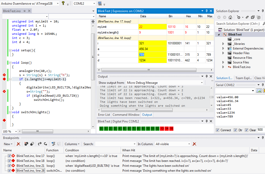
VisualMicroDebugAPMFastSerial.png

Visual Studio is currently the only IDE capable of debugging any Arduino project and is also aware of the special APM Serial communications system called FastSerial.

Debugging a drone project requires functionality that exceeds what a normal windows/linux debugger can provide. For example, setting a debug trace and reporting message in a fast loop would normally produce too many messages to be of any use.

The Arduino debugger in Visual Studio allows TracePoints (or BreakPoints) to be conditional based upon any arduino code (as would be expected by any serious debugger) but it also goes one step further by allowing messages to be limited to any specified rate such as 1 per second.

Another important feature of the Visual Studio debugger for drone projects is the ability to allow variables to be altered without the need for the program being debugged to stop execution (break). The VS debugger has a powerful feature that automatically queues requests to alter variables allowing the request to be processed when the code reaches the specified execution point.

ArduPlaneFastSerialDebug.png

Below we can see multiple "intelligent" messages have been configured to display execution information from an Arduino while the Arduino program is running. The text of these messages do not reside on the Arduino and therefore do not consume vast amounts of limited Arduino memory

DebugSetVariableRunningExample2.pngRead more here

Arduino for Visual Studio Professional is the only 100% compatible Arduino plugin. Visual Studio Pro can be obtained free for 3+ years

Read more…

AMARILLO – Dr. Charlie Rush hopes to use a unique method – helicopter drone – to track disease progression across wheat fields to eventually help producers make better irrigation decisions.

A helicopter drone is being used by Dr. Charlie Rush, Texas A&M AgriLife plant pathologist in Amarillo, to track disease progression across wheat fields. (Texas A&M AgriLife Research photo by Kay Ledbetter)

A helicopter drone is being used by Dr. Charlie Rush, Texas A&M AgriLife plant pathologist in Amarillo, to track disease progression across wheat fields. (Texas A&M AgriLife Research photo by Kay Ledbetter)

Rush, a Texas A&M AgriLife Research plant pathologist in Amarillo, has enlisted the help of Ian Johnson, a Montana State University-Bozeman graduate student who is using his work in the university’s Science and Natural History Filmmaking Program to help scientists conduct research.


http://today.agrilife.org/2013/11/25/agrilife-research-scientist-utilizes-drone-to-detect-wheat-disease-progression/

Read more…

APM 2.6 external compass making a difference

3689560537?profile=original


Last month, we had the opportunity to setup an APM 2.6 for a candidate, i.e. this baby will be shipped away after field test. We received one of those revised board that has no onboard compass, where the compass can be placed away from power and motor sources as far as possible to avoid magnetic interference. On this build, we decided to keep it simple, mount the compass/gps on the side bay, as shown on the picture, and the “compassmot” result was at an acceptable range 24% on the first run, so we just left it since then.  We average about 10 or more satellites, so we are getting good signal here.

3689560497?profile=original


We are pleased with how this external compass can significantly reduce magnetic interference; the loiter is good. We accepted the default PID values, with one exception, we adjusted the Loiter PID P to 0.5 (from 1.0) to reduce aggressiveness as recommended for this release.  The build time was reduced by half.


Thanks 3DR!


APM 2.6. Filmed with APM gimbal Keychain Camera #16 Lens D and with the default PID, out of the box DJI motor and propellers.

Read more…
3D Robotics

"Small Drones Deserve Sensible Regulation"

3689560953?profile=original

IEEE Spectrum has a very sensible opinion piece in their latest issue, arguing that small drones should not be treated like big drones and deserve a new approach to regulation. Excerpt:  

While many other countries are racing to develop and use such drones, U.S. innovators remain more or less stuck on the starting line, mired in federal indecision and red tape. At the recent Drones and Aerial Robotics Conference, at New York University, one speaker imagined what would happen if the Wright brothers were to face such restrictions today: Moments before takeoff, a black Chevy Suburban would pull up, federal agents would jump out, and they would halt the ill-conceived experiment for safety reasons.

While such intervention seems oddly reasonable today, government safety mandates are now being extended to astonishingly small scales. In 2007, the Federal Aviation Administration declared [PDF]  that small flying contraptions, even those the size of your hand, are considered “aircraft” and therefore require a Certificate of Authorization if they are flown outside for anything other than recreation—even if they hover just an inch above the grass. One high-level policymaker conceded that tossing a paper airplane for research or educational purposes would technically require FAA approval.

So it’s no surprise that many other countries, including Brazil, Canada, China, France, Israel, Japan, New Zealand, and Switzerland, are moving ahead of the United States in civilian drone use and development, the most rapidly growing sector of civil aviation. These nations are capitalizing on the emergence of new technologies, building patent portfolios, and creating high-tech jobs that a decade ago would have been located in the United States.

...

Fortunately, there’s a straightforward solution: Keep public navigable airspace exactly where it’s been for nearly a century now—hundreds of feet above our heads. This would leave landowners and local communities firmly in control of their backyards, neighborhoods, farms, and towns. Such a policy is also consistent with the landmark Supreme Court case United States v. Causby, which found that landowners “must have exclusive control of the immediate reaches of the enveloping atmosphere.”

This framework would ensure a far more human world, one where small drones are just tiny flying contraptions, not FAA-certified aircraft with the public right of transit over our tulips. These fascinating new tools could then be used where landowners and local laws allow, safely below navigable airspace and out of the way of full-size aircraft. This solution would give innovators some air to breathe and put the United States back in the game as the world begins the second century of civilian aviation.

Read more…

Continued Work Towards a "Virtual Gimbal."

One of the many projects I am currently working on is a, "virtual gimbal." The idea is that gyroscopic sensor data can be used in conjunction with post processing software to steady recorded video after the fact. This is different from existing software which attempts to determine motion based on reference points in the video, instead of direct data recorded during the flight. The reason for using a virtual gimbal as opposed to adding an actual gimbal to a UAS is to allow smaller systems, in the mini to micro range, to give relatively decent quality video without the weight expense of a gimbal system.

To date, my work has only considered the option of video being shot pointing in one direction, generally forwards, at a time. However, after seeing, and purchasing, the above shown camera at a toy store during Christmas shopping, I have decided I may have an additional feature to add. The Panosphere 360 camera uses a fisheye lens to record a single panoramic video, and then uses software to allow users to, "explore," this video afterwards. The results of this exploration can also be recorded for later playback as one continuous shot. As an example, I did a fly-by of a table in my house, with the small hexacopter I was using pointed in the same direction the entire time. As I played the video back (and recorded at the same time) I focused on candles on the table, and panned the shot around to follow them. The result looked as if a gimbal mounted camera had been turned during the flyby to keep focus on the candles. Granted, as this is just a toy, the quality was not great, and the low-light conditions did not help the situation. If anyone is interested in that video, I can post it up early next week after we return home from visiting relatives for Thanksgiving.

In my review above, I show my first basic attempt at shooting outdoors in better lighting. The camera was attached to a small hexacopter I recently bought, and briefly flown about twenty feet above my front yard. While this camera is just a toy, it was worth the $40 for the inspiration it has given me. I would like to see what might be possible with a better sensor, higher quality lens, and less buggy software.

The first iteration of my virtual gimbal software is being developed on the Android, as I am more familiar with coding on that platform, and the camera, sensors, and processing capability are all contained in one package. I will likely purchase a fisheye lens for my phone soon, and attempt to integrate this type of virtual panning feature. At this time, my software is in extreme alpha stage, but when I get something which works somewhat reasonable, and I develop a more intuitive interface, I will likely post a link for others to download and test.

Read more…

uPilot32 Test OSD on-board integrated MAX7456

Test of the uPilot32 UAV Devboard. The MAX7456 OSD Layout Display is composed of 30 rows and 15 lines.

Therefore, the WriteString functions has a x (1 to 30) and a y (1 to 15) to position the first character of the string in the screen.

See more about the MAX7456 OSD : http://datasheets.maximintegrated.com/en/ds/MAX7456.pdf

See more about uPilot32 : http://vgrsystems.free.fr

Code will be available soon here : https://code.google.com/p/vgrsystems-upilot32

Read more…

Prop Change

I have just purchased 4 new Graupner 10x5 Propellers to replace the existing APC 10x4.5 slow fly props on my TBS Style Quad as I was not happy with the vibration levels.
Thought I would share the results.

3689560737?profile=originalVibration levels for APC Props

3689560794?profile=originalVibration levels for Graupner Props

I had spent a lot of time trying to balance the APC props but could never get much improvement. I just balanced Graupner props very quickly and got the above result

David Ardis

Read more…


http://www.canadianmanufacturing.com/design-engineering/news/canadian-face-detecting-drones-respond-to-voice-gesture-commands-design-eng-125448


Researchers at Vancouver’s Simon Frasier University have developed a fleet of Unmanned Aerial Vehicles (UAV) that accept group voice commands or can be controlled silently through hand gestures. In addition, individual drones recognize which of them their controller is speaking to via on-board face recognition cameras.

Once a drone recognizes it is being singled out, it can be commanded to join or remove itself from the group. Packs of drones can then be given group commands such as take off, land or perform a pre-set mission.

To determine which of the drones is being commanded, each UAV rates the angle of the controller’s face relative to the camera. After comparing each other’s “Face Rank”, the drone with the highest score is then deemed to be the one targeted.

The controller can then tell the targeted drone to join the group by saying “And you” or remove one from the group with “not you”. Alternately, a controller can add drones by waving their right hand. Once grouped, sets of drones can be commanded with “You two” or “You three” to perform the same action simultaneously.

Presented at the the IEEE/RSJ International Conference on Intelligent Robots and Systems (IROS) in Japan this month, the researchers’ paper (pdf link) says work still needs to be done on the robotic drones face recognition system. In addition, they hope to expand voice commands so groups of drones can be given names (e.g. “You all are team red” etc.)

Read more…

DroidPlanner Telemetry Bluetooth Bridge

bt_bridge_1.jpgPleased with the way this has turned out for a Saturday project :-)

It compliments Arthur Benemanns DroidPlanner app to give a wireless link between the aircrafts radio and a Bluetooth connection to the Android tablet.

  • Its fitted with a 1000mah LiPo battery and charge circuit which is chargeable by a small USB slot at the bottom of the unit.
  • Ultrabright LEDs for the power and Bluetooth link for sunny days.
  • BT LED blinks when there is no connection and goes solid when connection is made.

bt_bridge_2.jpg

Read more…

3689560775?profile=original

November 25th… In an online news story by Oklahoma City Channel 9 News, FAA effectively endorsed AMA’s safety guidelines for the personal use of sUAS for agricultural applications. As reported by Justin Dougherty…

“Farmers may operate an unmanned aircraft over their own property for personal use … Guidelines for the operation of model aircraft, such as those published by the Academy of Model Aeronautics, may be used by farmers as reference for safe model UAS operations.”

http://amablog.modelaircraft.org/amagov/2013/11/26/faa-endorses-ama-rules-to-govern-personal-use-of-suas-for-precision-ag/

Read more…

"Terrence"*gets his gimbal running at last

3689560755?profile=originalOk, I've finally found some legs that I'm reasonably happy with, which means "Terrence" (formally known as Platypus) now has his gimbal in situ, and running!

The legs are Tarot's off the shelf, but seem to perform ok. The shape of the frame means they are toe-out, but this aids video clearance anyway, so may leave them as is.

Got the rest of the electronic to connect up tomorrow after fitting the legs, but should be ready for a test flight Friday.

Other notables in this "dot release":

- M2.5's from china have been binned, and replaced with some from Britain. Much better quality, but a couple still rounded. It might just be my allen key, but might also be the inherent limitation of M2.5. I could go to M3, but I'd need to redesign the clamps etc...hmmm.

- Terrence is flying well, but his CoG is well forward of CoT. 40mm forward, with a 10.0A 6S pack. However, this doesn't seem to affect him much! The rate of straight up climb is less than I expected, even with a full camera load. 3m-100m (relative, at starting height of 800m ASL) takes 10-12 seconds, which I think is a direct result of the APM throttling the rear motors to maintain stability. Not that you'd notice - at full throttle it climbs rock solid stable.

- immersion 25mW tx replaced with a 600mW and moved forward because of the legs.

- gimbal vibe balls replaced with harder items. Very secure now.

- a "hybrid" vibe solution is used. 4 x zeal corners suspect a G10 plate, which suspends the APM using 4 3M corners (ie one 3M square cut into 4). More data on this on Friday.

- I added a rubber "anti slip phone matt" into the battery bay. Surprisingly effective at holding the battery in place, and reducing vibes. You still need to velco tape down the battery though!

In short - if all the next tests go well (these are the crucial ones - the gimbal performance - it's what this is designed for!), I'll be looking to get the "gold" samples cut in February for the 3 volunteers from diydrones! (Hughes et al).

3689560706?profile=original

* Of Angry birds fame.

Read more…

21694a54c6761cced1f7f8ba4e1d0277_large.jpg?1384283514

Simple idea! This is how you sell drone era to mass consumer :)

I think I'll have one :)

PowerUp 3.0 turns your self-made paper airplane into a smartphone-controlled flying machine

  1. Fold It: Simply fold a piece of copier paper into a paper airplane
  2. Attach It: Attach the Smart Module to your paper plane with the patented clips underneath the Smart Module.
  3. Connect It: Start the app to connect to the Smart Module with your iPhone.
  4. Fly It: Push throttle to full and launch the paper airplane high up into the sky. Tilt your smartphone to the left or to the right to steer your plane, increase or reduce throttle to go up or down.


4b4edef3dce07b58fcc7cbaa4bd68ac2_large.jpg?1384375664871ce6d36514866d7634b8ae19d08a5a_large.jpg?1384371573

f44b02d89f02b2aa31116202a2533835_large.jpg?1384442284PowerUp 3.0 - Smartphone Controlled Paper Airplane

Read more…

24047984_BG2.jpg

I think this is actually the second attempt at this.  Wasn't there one last year?  Good to see that they actually caught the people involved and arrested them.  Hopefully it won't result in a knee-jerk reaction, but I doubt it.  The article is horribly written, but at least they didn't call it a "drone".

http://www.walb.com/story/24047984/crooks-get-creative-to-smuggle-contraband

Read more…

Overlaying GPS Coordinates for Camera Crosshairs

3689560630?profile=original

Hey Guys!

I am working on a project to allow us to implement GPS coordinates for the location of the crosshairs of a PTZ camera, other wise known as Geo-pointing.  This will essentially give us the LAT/LONG of what we are looking at.  

I have found several methods to do this, but I'm looking for the simplest way but accurate as possible.  I am fairly new to modifying APM and to MAVLink so instruction and suggestions are very welcome!  Here is what I have in mind:

In order to get this:

LAT/LON: Self explanatory

BRG: Bearing

SRG: Slant Range (Range from Aircraft to location)

GRG: Ground Range (Range from coordinate to coordinate)

I have a formula to triangulate the position of where the crosshairs are pointing relative to the aircraft by using trigonometry.  Here is the example:

3689560667?profile=original

3689560688?profile=original

The system will incorporate 1x APM 2.5 w/ GPS, 3DR Telemetry radios, 1x IMU w/ compass for camera gimbal, 2x MinimOSD boards, 2 cameras, 1x video TX with two-way camera switcher.

Method:

Application extracts altitude from APM and camera angle from Camera IMU and finds the tangent and cosine of the angle and finds the missing sides.  This will give us the ground distance and slant range respectively.

TAN(CAng)*Alt = GndDist     COS(CAng)*Alt = Slant

At this point the slant and ground range can be transmitted to the video feed.

Next, we use the aircraft's GPS coordinates from the APM and the ground distance to find what coordinate we are looking at on the ground:

aL-aircraft Latitude

aO-aircraft Longitude

cL-crosshair Latitude

cO-crosshair Longitude

A-aircraft Altitude

D-ground Distance

B-Bearing from Gimbal Compass


cL =ASIN(SIN(aL*PI()/180)*COS((D=TAN(A*PI()/180)/6378.137) + COS(aL*PI()/180)*SIN((D=TAN(A*PI()/180)/6378.137)*COS(B*PI()/180))*180/PI()

cO =((aO*PI()/180) + ATAN2(COS((D=TAN(A*PI()/180)/6378.137)-SIN(aL*PI()/180)*SIN(cL*PI()/180), SIN(B*PI()/180)*SIN((D=TAN(A*PI()/180)/6378.137)*COS(aL*PI()/180)))*180/PI()

These formulas are in excel format since it is what I used to test these.

This should give us the coordinate under the crosshair.

Next, I would like for this information to be sent to the second OSD for the gimbal camera.

Now my question is, how do I implement this?

I would assume that I can attach the IMU and compass via analog sensor input, however, I have no idea how to write code for it.

I also do not know how to write the code for the calculations to the APM in order for the APM to do all the formulas.  Can the APM handle it or do I need a separate processor?

How do I create a MAVLink message for the new coordinates and inject into the data stream?

How do I write the code to the MinimOSD to retrieve the new coordinates and display it?

These might sound like noob questions, but I come from a radio frequency engineer background and just now getting into programming.  I would love to learn how to do this stuff but there is very little out there on what I'm wanting to do exactly.  Sure, I can make an LED blink, and I know that's the basic skills, but I need to know how exactly to interface this with the APM and sensors.

Once again, all of your help is greatly appreciated and I very much welcome discussion and suggestions on a better way to do this!

-Hunter
Read more…


3689560611?profile=original

NavStik users are now using NavStik to build a variety of autonomous systems. Its extremely small size and light weight (4 grams), coupled with a powerful Cortex M4 processor and digital sensors, allow its use in a wide range of autonomous/intelligent mini and micro UAV systems. Users have successfully deployed NavStik on fixed-wing, rotary wing (co-ax), multicopter and flapping-wing MAVs.


Here is the raw video captured during one of the recent quadcopter flight tests:


Users at IIT Kanpur are using NavStik to fly autonomous rotary wing (co-ax) MAVs:


They have also successfully stabilized a flybarless co-ax using NavStik:


More details are available, here: http://navstik.org


If you are using NavStik for any of these applications, we will be happy to help you out!

Read more…