All Posts (11086)

Sort by

VirtualRobotix new products revealed

3689562573?profile=original


It is with great pleasure that we are able to present the result of our latest work.

In the last 4 months we designed, built and tested 2 frames and 2 Gimbals.

This is just a preview of these new products, production will start in the next month and pre-orders are available through our freshly re-designed web site www.virtualrobotix.it


Black Ops Drone aka B.O.D.

A multipurpose drone specifically designed for gaming and simulated wars. It is a plastic 2 shell frame very resistant and light weight. It is splashproof and can mount a small FPV camera on front. It can be used with many different payloads and mounts 3508 motors with 13" propellers.

VR_BOD1.jpg?width=700


VR TIGER SHARK

A powerful, tough and yet simple frame built with only 3k twill carbon fiber and High grade Aluminum.

The frame is designed so that X4 or X8 configuration is possible without any other add-on.

It is extremely tough and resistant, and host propellers up to 14" or 15" .

Typical configuration is with 3510 or 3508 Motors with 13" props, but also 40mm. motors can be mounted with no problems. The arms can be shifted in 1,5cm. steps to allow bigger props (15").

3689562531?profile=original


VR SHOCKWAVE GIMBAL

A professional 3 axis Brushless Gimbal built with 3k twill carbon fiber that is able to carry 3Kg. of payload.

This is our masterpiece. It uses high quality Stainless steel bearings and it is integrated with adjustable height landing gear.

It weights about 600gr. and it offers super smooth camera compensation.

3689562586?profile=original


VR SHOCKWAVE HANDY

The same Shockwave Gimbal can be used on our hand-held system allowing camera operators and professional photographers to obtain perfect stable images. The hand held mount can be equipped with remote control for PAN, TILT, ROLL and ZOOM.

3689562607?profile=original


VR EASYSHOT GIMBAL

A 2 or 3 axis Gimbal designed to fit the most common and light to medium cameras such as:

Sony NEX xx

Canon M series

Sony Cybershot VX420 or similar

Totally built wi Alu and Carbon fiber it is extremely light and it is sold with an antivibration plate suitable for any frame. It's weight without mootrs is 280gr. and is perfectly able to carry 300-400gr. of payload.

3689562542?profile=original


Please refer to www.virtualrobotix.it for more details and don't hesitate to askany questions.

The VirtualRobotix team


Read more…

5 Things I Think Will Revolutionize the APM

  1. The Release of the 3D Robotics Rover.  This is extremely significant because an APM compatible rover will help drive up the amount of users and contributors to the Rover side of the APM Open Source Development (ArduRover is used far less than ArduPlane and ArduCopter).  Once ArduPlane, Copter, and Rover all become more equal as far as user base we should start to see the APM turn into a more universal product that will be getting extremely close to being ready for commercial applications and entrepreneurs.
  2. The ability to Run Multiple Ardu Softwares simultaneously for "Hybrid Type" vehicles like a QuadRover, HeliBoat, or QuadPlane)  These types of vehicles seem to be very popular with the hobbyist base of APM users who enjoy building their own vehicles and concepts themselves.  The real do it yourselfers in the Diy Drones Community aren't limited by creativity or imagination for drone concepts.  We are limited by the small selection of affordable Drone Hardware, Accessories, and overall product selection when it comes down to commercial grade products at a consumer price.
  3. Sense and Avoid open source collaboration will take off like a rocket when 3DR releases their Rover Platform because this will allow for this extremely large community to take part in the development of Sense And Avoid Software safely from the ground.  If you seemed puzzled by my last sentence try looking at it this way.  The community can't safely Open Source Develop a good Sense and Avoid System in the "sky" because this is not only extremely dangerous but we would all go through a dozen quads a month testing out confirmed and potential software codes for the system.  "I estimate that 50% or more of the software for an Aerial Sense and Avoid System could be written safely on the ground using rovers".
  4. The release of APM compatible accessories and attachments will allow for a wider variety of applications that the APM will be able to be used for.  This will also allow for a wider variety of companies and entrepreneurs to join in on the Open Source Development and Collaboration. "This will revolutionize this community greatly because during open source development here the biggest obstacle is that we all use different brands of electronics which doesn't allow for everyone to be able to run certain functions or software with the equipment they own".  "If we are all universally using the same brand (such as 3D Robotics) electronics, attachments, motors, batteries, etc it will take this Open Source Community to the Upper Echelon of Open Source Communities".
  5. The Release of 3D Robotics Marine Vehicles such as water surface vehicles and submersible marine vehicles.  Currently Agriculture is ranked as the #1 current marketable application for commercial drones but I would argue that before the end of the decade the Marine Drone market will be the largest non military application for commercial grade drones .  This will allow for universities all over the world to add a low cost submersible drone to their current marine biology and oceanography programs with a low cost marine vehicle for lakes and other bodies of waters.  It would probably catch the eye of government agencies like the Department of Natural Resources and other environmental groups and agencies who are currently looking to attach sensors and hi-tech cameras onto Quads and Marines Vehicles for scientific purposes such as Environmental 3D Mapping and ecosystem management.  Many government agencies need these ASAP so if a company like 3D Robotics can provide them with a suitable product the Government is more likely to award grants to companies like 3DR for Drone R & D


"Take it Easy Diy Drones",

Joshua Johnson - Diy Drones News- Drone Cafe -

Read more…

How to build a VTOL aircraft. Completed

3689562415?profile=original

Thank you to everyone that supported producing brief explanations on how to build a VTOL aircraft. It was a fun little project from which I learned a lot from.

I am particularly happy with the performance of all these aircraft which turned out better than their prototypes and especially the Quad-Airplane which uses only three servos. 


Here are a few more videos and images of the Quad-Airplane and others that we were able to produce...


Bicopter- Airplane

3689562337?profile=original


Swept Back Wing

3689562435?profile=original


Swept Forward Wing

3689562502?profile=original

Read more…
Moderator

anderson-500.jpg?width=200

Entrepreneurs need lots of data about their desired customers before they build a product. Chris Anderson, CEO of 3D Robotics and progenitor of the modern "do it yourself" (DIY) drone trend, understood this well: Before founding his drone company, Anderson went about figuring out exactly what the world wanted.


Anderson created diydrones.com, a forum where amateur tinkerers and engineers trade tips on how to make all kinds of unmanned aerial vehicles (UAVs). The forum has been an ideal focus group, and what has become clear is that, while normal people are obsessed with flying robots, they don't want to invest in building them from A to Z.

The solution? Manufacture and sell low-cost drones to the masses. And that's exactly what Anderson is doing. "We created the community, then the product," Anderson told the Verge in September, a day after announcing a $30 million financing round for 3D Robotics, which is building unmanned airplanes and helicopters. With his new money, many observers say, Anderson could really break open the market for mainstream UAVs. In 2012, Anderson's company sold over $5 million worth of drones—and this year, sales are projected to double.

Anderson envisions a day when mass-market drones make everyone's lives a little bit easier—a prospect that would bolster his company's bottom line. That goes for farmers who could use UAVs to monitor crops or cattle, as well as emergency responders who could use them on rescue missions. To get there, Anderson plans to continue his step-by-step approach to entrepreneurial success. "What comes next is the platform," Anderson, former editor in chief of Wired, told the Verge, "the software that makes drones useful to people in the real world."

http://www.foreignpolicy.com/2013_global_thinkers/public/

Read more…

3689562314?profile=original

I have some real concerns about this article.  Although this article talks about commercial hijacking, I feel this could very well happen to me and other hobbyists.  And what can DIY Drones help develop to reduce this probability?

http://defensetech.org/2013/12/09/hacker-releases-software-to-hijack-commercial-drones/?comp=1198882887570&rank=4


Read more…

prime-air_high-resolution02_large_verge_medium_landscape.jpg


http://www.theverge.com/2013/12/10/5195864/amazon-prime-air-drone-illegal-faa-international


Amazon and the FAA have confirmed to the Washington Post that the company chose an international location to shoot its concept video for Prime Air, the drone delivery service CEO Jeff Bezos says Amazon plans to debut in the near future. That's because the commercial use of drones is currently illegal in the United States, pending new regulations set to be issued by the FAA in 2015.

The laws concerning drones are far more relaxed in neighboring countries like Canada, which is a relatively short trip from Amazon's headquarters in Seattle, Washington. And while commercial use of drones is illegal, numerous photographers and cinematographers working on projects in the United States have confirmed to The Verge that the use of drones to achieve aerial shots is common.

American advocates of commercial drone use point to situations like this as proof that the United States, which has been a leader in developing small unmanned aircraft, risks falling behind the rest of the world in terms of developing drones for business, due in large part to the lack of a complete regulatory framework.

Read more…

  3689562396?profile=originalThe University of North Dakota has been at the forefront of UAS Operations education since 2009.With more than 130 students enrolled, and having more than 50 graduates to date, the program is continuing to advance the nature of Unmanned Aircraft Operations education. 

This semester, another fifteen students at UND had their first introduction to the myriad systems that make up unmanned aircraft systems.  Building and flying their first unmanned aircraft (3DR Quadrotor), these students were able to experience hands-on integration of the essential systems common to nearly all unmanned aircraft.  While not engineers, the students learned valuable lessons (theory, too) about open and closed-loop controls, propulsion systems, aircraft and rotorcraft aerodynamics, potential energy systems, systems monitoring, ground control interfaces, flight planning and communications.  Their hands-on experiences are proving to be the single-greatest avenue for introduction to complex technologies and their integration to form capable complex systems.

Thanks to 3DRobotics for helping make this learning experience possible.

Read more…
3D Robotics

Using GoPros for aerial surveys

3689562299?profile=originalFrom Agribotix:

In many ways the GoPro is an ideal camera for drones: small, light, rugged, decent resolution, and not too expensive.  The show stopper is the fisheye lens that makes image stitching impossible.  Now there could be a fix on the way.  Backbone, a Canadian company, is making an aftermarket hack to allow C-mount lenses to be used with the GoPro.  An as an extra bonus for those of us interested in NDVI, the IR filter is optionally removable.  Their product, called the Ribcage, will be a bit pricey at $200 (in addition to the cost of the GoPro) but it might turn out to be a comparable solution to something more expensive like the Sony NEX series cameras.  The Ribcage isn't available now, but it should ship soon.

Read more…
3D Robotics

DHL latest to experiment with drone delivery

3689562314?profile=originalFrom the AP:

FRANKFURT, Germany (AP) — Germany's express delivery and mail company Deutsche Post DHL is testing a drone that could be used to deliver urgently needed goods to hard-to-reach places.

The small pilotless helicopter flew a package of medicine Monday from a pharmacy in the town of Bonn to the company's headquarters on the other side of the Rhine River. The aircraft can carry up to 3 kilograms (6.6 pounds).

Company spokesman Thomas Kutsch says the flights all this week are strictly a research project to see if the technology works and there are no plans yet to start actual drone deliveries. The test flights required permission from local aviation authorities.

Read more…
Developer

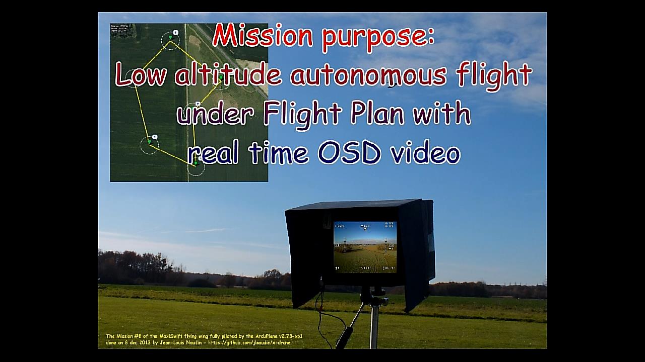
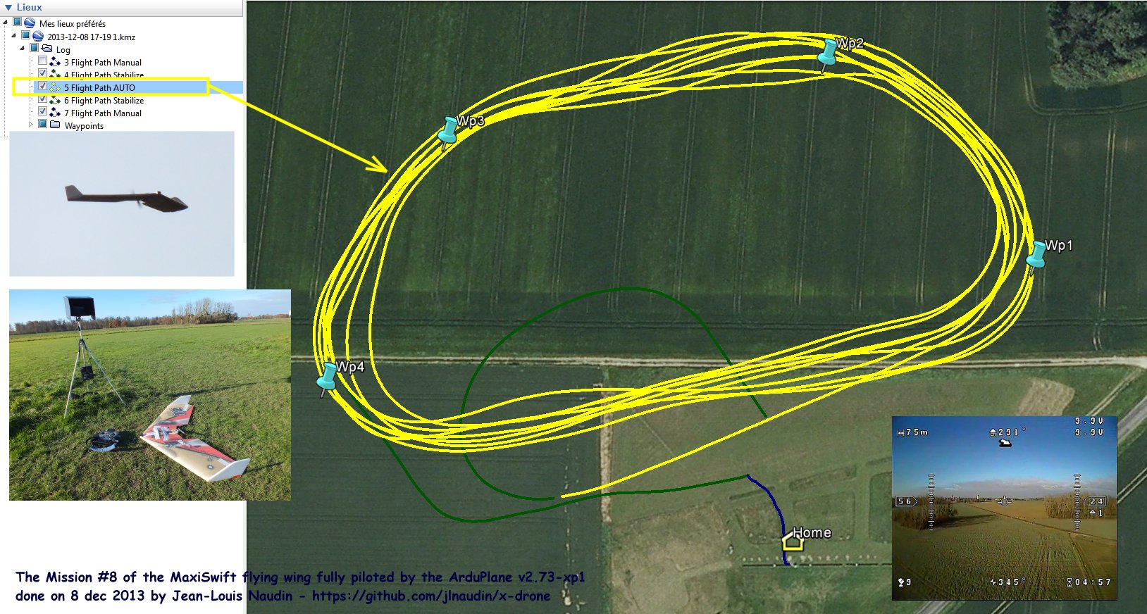
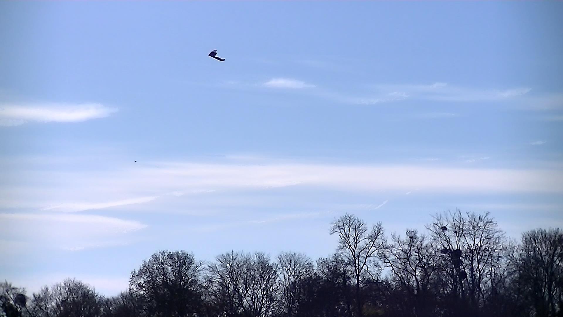
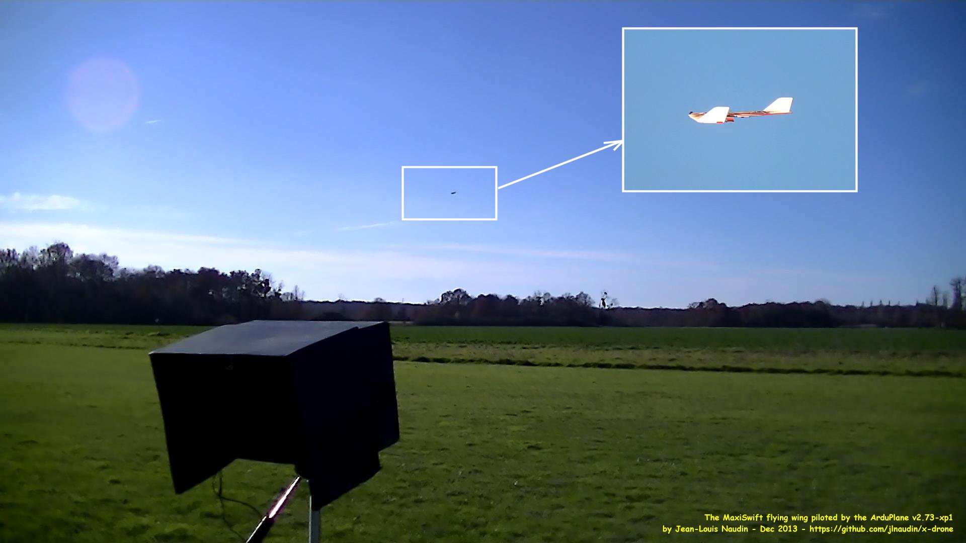
The MaxiSwift flying wing has donne successfully a low altitude flight autonomous mission (< 30m AGL) under flight plan piloted by the ArduPlane v2.73-xp1. A color camera onboard with an OSD display in real time the video of the flight and the data on the ground station screen. (Wind 7 km/h, gusting 15 km/h)

- Avionic setup:
- ArduFlyer v2.5.2 (RCtimer)
- firmware ARduPlane v2.73-xp1 (JLN version)
- GPS: Crius CN-06 V2 (Ublox NEO6M) updated by JLN
- Airspeed sensor MXV7002DP
- OSD Rembizi
- 5.8 Ghz Video transmitter
- CCD color camera for FVP
- Receiver: Multiplex RX-7 M-link
- Transmitter: Multiplex Royal EVO9 M-link 2.4 Ghz
- Lipo 3S 2650 mAh Turnigy
- Brushless motors Spitz 15 #85570/200 Watts 1130KV
- propeller 10x7 APC-E
- ESC 40A for the motor
- Take Off Weight (TOW): 1240 g
- Flight time: about 15 min

Below some photos:

MaxiSwiftMission8purpose.jpg?width=640

FlightLogmiss8.jpg?width=720

maxiswift6.jpg?width=640

maxiswift8.jpg?width=640

Full mission photos and data at: 

https://github.com/jlnaudin/x-drone/wiki/x-drone:-MaxiSwift,-mission-8---Low-altitude-profile-mission

More infos at:
https://github.com/jlnaudin/x-drone
http://diydrones.com/profile/JeanLouisNaudin

Read more…

StingrayCY(1).jpg


This multirotor has the ability to go full 3D flight at an amazing speed. It is going to revolutionize the multirotor world.

Features:

  • Unique Fully Aerobatic Quad
  • Higher performance 3D flight capable
  • Stable and smooth beginner flight
  • Includes TG-Multi flight control
  • Durable and simple VP design
  • Pre-painted clamshell body set


Specifications: Span: 490mm (diagonal rotor to rotor) Blades: 110mm Frameset: 85% carbon and metal design Drive System: Single Motor
Includes:

  • Frameset (metal, carbon, plastic)
  • TG-Multi flight control (upgradable, used in VP Quads, Helicopters)
  • Blades (4 sets)
  • Pre-Painted Body Set

Needed to Complete:

  • 4S 2200 - 3000mAh 30C+ Battery
  • 6 Channel Transmitter & Receiver
  • (4) Servos - High Performance Digital Servos (0.8 sec/60° @ 6V minimum)
  • 45A ESC w/5A BEC
  • 3000kV / 390W Motor


Read more…
3D Robotics

Good analysis of FAA drone rules by GigaOm

3689562240?profile=originalInteresting sentence in this GigaOm article: "While the FAA suggested in 1981 that model aircraft operators fly below 400 feet, the document was just an advisory, and two aviation lawyers contacted by Gigaom said the agency has no authority below 700 feet — for now."

Excerpt:

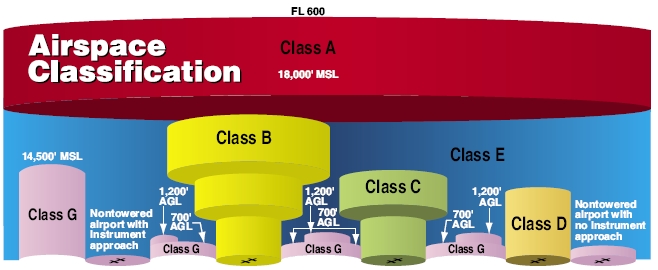
Airspace is sliced up into different regulatory layers from the ground unto outer space. The Federal Aviation Administration pays a lot attention to Class A — all U.S. airspace from 18,000 to 60,000 feet — where commercial planes fly. Then are the airspaces around airports, called Class B (big airports), C and D (smaller cities), that look like inverted wedding cakes and stretch up from the ground.

Drone fans, pay attention to Class G: an unregulated space from the ground to 700 or 1,200 feet, where the drones can fly below the airport tiers. Here’s an FAA image(I’ve added the arrows):

FAA Airspace

The 700 to 1,200 feet rule is distance from the ground, not sea level — so if you’re in Denver or another high altitude city, you can fly higher. Here’s a partial view of how aPopular Mechanics explainer chose to show the airspace:

FAA airspace by Popular Mechanics

While the FAA suggested in 1981 that model aircraft operators fly below 400 feet, the document was just an advisory, and two aviation lawyers contacted by Gigaom said the agency has no authority below 700 feet — for now.

“The FAA is already looking at it .. but it’s not going to happen for two years,” saidJohn Todd of Todd & Levi in New York, who noted that the number of amateur drones in the sky is growing quickly.

Read more…

Pilot's logbook

3689562216?profile=originalIn an effort to further professionalize the operation of drones, I was looking around for templates where I can log flight hours and model maintenance. I want to be able to turn over some documents that show flight hours, experience and that I'm serious about how maintenance and flights are executed. To interpret this correctly, I add that I restrict operations to the following constraints, based on what current legislations seem to agree on internationally. These are 6 simple rules that I always comply with:

  • less than 3.5 kg model weight
  • less than 400ft altitude
  • less than 500m distance
  • non urban areas
  • permission of land owner
  • 2 miles away from airports and helipads, or prior contact and flight scheduling

It doesn't make a lot of sense to copy verbatim the logbooks used in general aviation. First, the type of piloting/operation is very different. Second, the importance of the motor, propeller versus the rest of the equipment is negligible, so separate logbooks for motors and props don't make sense.

So I've started on a little suite of apps for Mac OSX where I intend to keep my own logs. They will be kept for a month and then printed, signed off and archived. The one above is the pilot logbook, an example of general aviation available here:

https://dl.dropboxusercontent.com/u/11452962/Pilot_Logbook.pdf

As you can see, the "condition of flight" and "piloting time" you find on those logbooks do not reflect how drones are usually operated. You can be either pilot in control (having direct manual control), but in other cases allow the drone to be operated automatically through an autopilot, in which case you become an operator in control. There are also other options like instructor or receiving instruction from others, all which counts towards flight time. The condition of flight is also different. It doesn't make sense for civil applications to fly in night time or in IFR conditions, because you must always have VLOS.

I think the most important contribution is the 'stress level' column. This reflects the maximum stress level of the pilot/operator during the flight. The idea is that the pilot reflects on the flight and determines what made him feel uncomfortable. It may be that training is needed to deal with flying close to equipment installations. In other cases it may be high wind situations and not feeling entirely in control of the craft. In the end, the objective is to find out where additional training is required, or find out where technology can be improved or substituted to remove this anxiety. So I think this column really helps to make future flights safer and safer.

I intend to make similar apps for maintenance activities on aircraft and a separate 'crash analysis book'. The objective is to demonstrate that aircraft are subject to regular maintenance and that crashes are taken seriously and need to be analysed in great detail to take measures that prevent them in the future. I think those 3 books should be enough for crafts and operations this small (subject to above constraints). In comparison, full-scale aviation has at least 5 logbooks to keep and I do not see any value in complying with those bureaucratic demands.

The idea is to demonstrate commitment to safety when operating the technology at somewhat larger scales. The logbooks aren't necessarily legal or approved, but they're certainly better than nothing or statements like "well, we never had an issue in about 200 flights we executed". Also, when people start flying for you, you want to have insight into what makes people nervous, what the frequency of maintenance is, what they find there, which components need replacement often, do we need to switch suppliers and so on. So also from a financial and general operation perspective, it makes sense to start tracking what goes on in the outfit.

Comments are welcome.

Read more…
3D Robotics

3689561917?profile=original

From an interview with the Guardian newspaper (UK).  [UPDATE: This is actually a repost from April. Sorry about that!]

The use of cheap, miniature "everyman" drones needs to be banned by international treaties before such devices fall into the hands of private users including terrorists, the head of Google has said.

In an extended interview with the Guardian, Eric Schmidt, executive chairman of Google and an adviser to Barack Obama's presidential campaign, warned of the potential of new technology to "democratise the ability to fight war", and said drones could soon be used to harass and spy on neighbours.

"You're having a dispute with your neighbour," he hypothesised. "How would you feel if your neighbour went over and bought a commercial observation drone that they can launch from their back yard. It just flies over your house all day. How would you feel about it?"

Schmidt set out the trajectory of robotic warfare and considered whether it would be confined solely to national governments. "It's probable that robotics becomes a significant component of nation state warfare," he said.

"I'm not going to pass judgment on whether armies should exist, but I would prefer to not spread and democratise the ability to fight war to every single human being.

"It's got to be regulated. You just can't imagine that British people would allow this sort of thing, and I can't imagine American people would allow this sort of thing. It's one thing for governments, who have some legitimacy in what they're doing, but have other people doing it … It's not going to happen."

Read more…
3D Robotics

3689561926?profile=original

 — Drones soon could help Tijuana authorities monitor traffic, evaluate accident scenes, detect landslides and control wildfires.

Mayor Jorge Astiazarán said this week that he’s preparing to buy several small, unmanned aircraft for the city, making Tijuana one of the first municipal governments in Mexico to use drones.

“The main idea is that they help with surveillance of the city,” Astiazarán said in an interview. “This won’t just be used for public safety, but to see how the city is growing, discover clandestine dumps ... monitor any land movement in a remote area that has gone undetected.”

The purchase is part of the city’s effort to increase efficiency through technology. So far, the only municipality in Mexico that uses remotely piloted vehicles is Puebla in central Mexico, which launched a drone program in October after acquiring three small unmanned vehicles.

On the night of Nov. 30 in Tijuana, images taken from a drone hovering above City Hall were displayed inside the courtyard where hundreds gathered for Astiazarán’s swearing-in ceremony. The mayor stopped short of mentioning drones in his inaugural speech, but he pledged to make Tijuana a safer city “using all the tools that are within our reach, both human and those that technology offers us.”

Astiazarán said he has been in negotiations with 3D Robotics, a company with engineering offices in San Diego, business and sales offices in Berkeley, and a manufacturing plant in Tijuana.

The first step involves the purchase of two 3DR Ready-to-Fly Quad drones. Each weighs as much as 6.6 pounds and can carry up to 2.2 pounds, said Guillermo Romero, general manager of the company’s plant in Tijuana plant.

The drone is primarily equipped for aerial photography. The images it captures can be used to quickly and inexpensively produce 3-D maps, Romero said.

Alejandro Lares Valladares, Tijuana’s new public safety secretary, said the drones could supplement a network of video surveillance cameras first installed in 2006 and monitored through a command center in the city’s Río Zone. Officers would be trained to operate the drones and read images sent to the command center, enabling them to help officers on patrol in problematic areas, Lares said.

...

“What we want to do in this administration is evolve technologically,” Lares said, adding that he’s also hoping to increase the use of electronic tablets and smartphones to improve communications and speed up response times.

Eduardo Vázquez Rossainz, director of Puebla’s Center for Emergencies and Immediate Response, said the municipality’s three drones can fly up to 820 feet above the ground and carry up to 24 pounds each. They have been used to monitor flooding and oversee mass gatherings.

“It’s less expensive to fly a drone than a conventional helicopter,” Vázquez said in a telephone interview. “A drone has capabilities that a patrol officer doesn’t. It has access to dangerous areas that a human cannot reach.”

In Mexico, the drone programs in Puebla and Tijuana have yet to stir up the level of public controversy that’s taking place in the United States, where Congress has required the U.S. Federal Aviation Administration to open up domestic airspace to drones by 2015. Current regulations prohibit use of drones in populated areas or near airports.

...

While Mexico has no laws governing the use of drones, Romero of 3D Robotics said the company is urging those who purchase drones to abide by international standards established for operators of remotely controlled model airplanes. Those rules require the vehicles to remain in the operator’s line of sight, not fly over private property and not soar above 400 feet, he said.

“We want to integrate this technology into civilian usage here in the city, without putting at risk individuals or private property,” Romero said.

Read more…
Developer

The Computer Vision and Geometry Lab of ETH Zurich (Swiss Federal Institute of Technology) might be in this community mostly known for Pixhawk and PX4, but our research focus is in fact 3D reconstruction, which means to create 3D models from 2D images (mostly, but we also use RGB-D cameras).

To reconstruct an object, the user takes a number of images from different viewpoints around the object and the 3D points will be rendered as they have been measured over multiple images, iteratively building the complete 3D model. Use cases include culturage heritage (like the objects shown in the video), building 3D photos / statuettes of your family or even reconstructing a couch (or a heating system) to see the if the furniture fits your living room or the heating appliance fits your basement. 3D reconstructions will become as usual as 2D pictures are today.

The novelty in what we presented now for the first time publicly at the International Conference on Computer Vision in Sydney, Australia lies in that the 3D model is created interactively directly on the phone, allowing the user to intuitively understand if he has acquired enough and the right images from enough viewpoints to create a complete 3D model. The previous state of the art required to take images, upload them to a server and only get a 3D model back many minutes later. We still can leverage the cloud computing power to refine the model obtained on the phone.

It can be compared to the move from analog to digital photography: A digital camera allows to preview how the image looks while (or shortly after) taking it, as does our approach. The previous state of the art meant to take images and only get the result back later, potentially after having left the scene and not being able to take a better picture or adjust the viewpoint.

These results are highly relevant for sUAS / micro air vehicles, because the processing boards available for these small platforms use the same type of processors as mobile phones. Because our technology also provides camera position feedback (suitable to steer the aircraft without GPS at a rate of 20-50 Hz and ~20-100 ms latency) it can be used to autonomously reconstruct larger objects. While vision based flight has been demonstrated earlier successfully (e.g. by our group or our colleagues from ASL), the results obtained on the mobile phone add a dense 3D point cloud (allowing things like terrain following and autonomous waypoint planning around the object) and add very efficient processing on top. We do plan to leverage both normal cameras and RGB-D cameras as they become available in small form factors.

The app is at this point a technology demo and not available for download. Our intent is however to bring a demo version of it into end-users hands as soon as possible, but we can't provide a date yet.


3689561891?profile=original

Read more…