All Posts (11086)

Sort by

3689651476?profile=original3689651389?profile=original

The recent 2015 Embedded Linux Conference held March 23-15 in San Jose, CA featured some great presentations related to drones. Videos of those talks are now available, and it's been a great pleasure to watch them.

Here is  an overview for easy reference, with a short description (my personal take) for those of us interested who were not able to attend. Be sure also to check the link above, many presentations are not covered here, yet could be of interest.

Cheers to all speakers, the DroneCode and Linux foundations, 3DRobotics, and the companies sponsoring the foundations and speakers!

-Olivier Brousse

----------------------------------

Keynote - DroneCode Project and Autopilot With Linux, by Andrew Tridgell: Slides, Video

In this talk, master open source developer and uber hacker (Samba and  Rsync, prior to Ardupilot)  Andrew “Tridge” Tridgell  presents  the history of the open source Ardupilot flight controller, from the beginnings of Ardupilot  to current applications and the foundation of DroneCode.  He covers the Arduino world and the open source community, the creation of this  forum by  Chris Anderson, through to his involvement in Ardupilot and the subsequent  hardware and software evolution. Tridge then presents the many applications in which Ardupilot is being used, and discusses the structure of Ardupilot code and its ports to Linux.

Autonomous Navigation for an OMAP4 Nano-Drone, by Grégoire Gentil: Slides, Video.

In this presentation Gregoire Gentil of Always Innovating presents the nano drone “Dronie” (aka MeCam), a quadcopter capable of autonomously following a person using computer vision. The Dronie’s flight controller is based on Texas Instruments’ OMAP44x board, boasting  a dual Cortex A9 kernel, a dual cortex M3 running TI’s Real time operating System, and a DSP used for computer vision.  Along with a 9 DOF sensor and a sonar, up to five cameras can be aboard the tiny drone. After a general hardware presentation, including the basics of how drones fly, Gregoire demos the drone following himself (no GPS!), and discusses the computer vision software algorithms that he developed. He concludes the talk by discussing sensor fusion details and the challenges he had to overcome.

If you are relatively new to drones, curious about “what’s under the hood”, and only have time to watch one or two of these presentations, this technical and entertaining talk, along with Tridge’s keynote, may be the one for you.

“Open Source Drones on Linux”:  Lorenz Meier, Slides, Video

In this presentation by drone pioneer and ETH researcher Lorenz Meier , the founder of the hardware and software open source PX4/Pixhawk  flight controller platform  presents a retrospective of the work he was involved with, and what’s ahead with the DroneCode foundation.  Lorenz, who is also behind the Mavlink  protocol and the  Qgroundcontrol  ground station software, starts out presenting the long history of Linux used in robotics and drones. He then discusses details of the PX4 platform and its software architecture, details current challenges and limitations, and provides information on the future of PX4. A great Q&A session follows, including further discussions on the second release of the Robot Operating System  (ROS2) , the UAVCan protocol, wireless link security considerations, and DDS to augment the capabilities of Mavlink.

“Drone API: A Tutorial on Drone Control”: Kevin Hester:  Slides, video.

In this talk, software and Ardupilot developer  Kevin Hester presents  DroneAPI, the  application development toolkit  allowing programming of simple 'high level' drone operations (e.g. move the drone to this position, perform that task there, etc ...). He shows how easy it is to get started, setting up “live” the development kit on a Vagrant virtual machine environment. He then runs some programming examples featuring Ardupilot computer simulation (Software in the loop, or SITL) , discusses  how they can be used further, and introduces the cloud-based app  DroneKit.

 “Application of Data Fusion to Aerial Robotics”, by Paul Riseborough: Slides, Video.

Here the Extended Kalman Filter master and Ardupilot developer Paul Riseborough covers the EKF which he developed for Ardupilot based flight controllers. Paul discusses the limitations and challenges of off-the shelf gyroscopes and accelerometers needed to control drone stability, covers sensor fusion, and provides a clear high level overview of why the filter is needed and how it operates.

 “Flying Penguins: Embedded Linux Applications for Autonomous UAVs”, by Clay McLure: Slides, Video

In this talk Clay McLure recounts his recent experience in the world of drones, where in just six months he built and flew his first drone and successfully developed onboard code for precision landing.  In this wide ranging presentation Clay  discusses the basics of ROS (Robot Operating System) and how he used it with Pixhawk via Mavlink and MAVROS.  He then details the code that he developed and how it runs on a companion computer.  

Using Intel Edison to Fuse Embedded Linux With Existing Drone Flight Controllers, by Mark F. Brown:  Slides, Video

In this presentation Intel engineers Mark Brown and Joel Rosenzweig present their implementation of a hardware and software environment allowing for autonomous drone flight,  on top of an existing manual (non-autonomous) flight controller treated as a “black box”. Starting with a DJI Naza running proprietary code, they use an Intel Edison running Linux and build a Node.JS web server to allow for setting waypoints over Google maps. The Edison is also connected to an additional GPS and IMU to control the Naza flight controller. This is implemented with the help of three Atmel A328 micro-controllers providing the “glue” between the Edison and the sensors. A Parralax P8X32A board then multiplexes serial commands from the Edison and RC inputs, and outputs PWM to the Naza. An impressive endeavor which was completed after hours in under eight weeks!

The Syria Airlift Project: Open-Sourcing Humanitarian Airlift, by Mark Jacobsen: Slides, Video

In this presentation US Air Force pilot Mark Jacobsen, founder of the crowd funded  Syria Airlift Project, presents his project, which “seeks to use humanitarian drones to deliver life-saving aid to besieged and hard-to-access populations in Syria”.  No doubt familiar to many readers of this forum, this great endeavor is a beautiful example illustrating how drones can be used for the greater good. If you find this project worthwhile please consider contributing to the Indigogo campaign!

Teaching More Fish to Fly,  by John Hawley:  Video

In this talk John Hawley , Open Hardware Evangelist at Intel, first discusses the rise of small drones from its DIY/Makers origins to the commercial world.  He presents his use of the powerful  Minnowboard Max as an auxiliary computer that can be used for vision processing, allowing features like collision avoidance. The Minnowboard is connected to the Pixhawk flight controller taking advantage of Pixhawk’s serial interface, similar to the way a Rasberry Pi or Odroid have been connected and used. John then discusses applications where auxiliary computers are used. 

Heterogeneous multi-core architecture support for DroneCode, by Mark Charlebois: Slides, Video

In this highly technical Linux talk Mark Charlebois of Qualcomm discusses porting the PX4  flight controller software to the Qualcom’s SnapDragon 600 hardware platform.  Mark first introduces the SnapDragon board with its four Krait cores and Hexagon DSP and discusses the board’s overall hardware architecture. He then presents his approach and work porting the PX4 software environment from its native Nuttx real time operating system to Linux, running on the SnapDragon. If you are a Linux programmer new to the PX4 flight stack this talk is for you!

Additional Talks

While not specific to drones, I also found the following enjoyable and informative:

 “Embedded Linux moves into High School Robotics”, by Michael E. Anderson: Slides, Video

I enjoyed watching this talk introducing the world of robotics in high school environments. Presenting the FIRST (For Inspiration and Recognition of Science and Technology) Robotics competitions, Michael Anderson introduces and details the RoboRIO Robotics controller, shows some example code, and shares his experience overseeing student teams.

10 years of open-source robotics, by Laurent Pinchart: Slides, Video

A great retrospective by Laurent Pinchart of his 10 years of involvement with the Eurobot Robotics competitions occurring in Europe every year. 

Creating Open Hardware Tools,  by David Anders: Slides, Video.

In this presentation David Anders of Intel reviews the history of open hardware tools used to debug hardware environments, from the humble multimeter in the beginning to logic analyzers and specialized boards necessary to debug today’s complex hardware platforms.

Read more…

First in World Flying Tank " B-Unstoppable"

Hi 

B-Unstoppable is the first in the World hybrid Tank-Quadcopter, with patented solution. Due to the caterpillar tracks B-Unstoppable achieves outstanding performance in driving across difficult terrain.

It can turn on the spot, which is extremely useful in limited space, which provides 360 view for on-board camera.  When obstacles become too big, it can simply take-off and fly over them. The model weighs only 84 g, therefore it can be operated nearly everywhere, without the worry of falling down and causing damages to others or model itself.  

 READ MORE https://www.kickstarter.com/projects/2017062404/b-unstoppable

Read more…

One Step Closer to Transformers

3689651143?profile=original

The good folks at EPFL have a folding drone that unfurls in a fraction of a second. Check out the story along with a video.

Engineering teams around the world are putting significant time, effort and research dollars into the idea of using aerial drones in disaster relief scenarios. It makes a lot of sense: Drones are able to fly into dangerous or inaccessible locations and — outfitted with cameras and communications gear — can provide reconnaissance imagery of a disaster site or even make initial contact with survivors.

One of the impediments to deploying drones, however, is that they tend to be unwieldy in terms of transport and launch. A new project underway in Europe hopes to solve this issue by way of a pocket-sized, fold-up drone that’s easy to transport and can self-deploy in seconds.

Full article here EPFL Folding Drone

Read more…

An app store for drones

3689651256?profile=original

As introduced previously, we've been working over the last months with Canonical to push an app store based on Snappy Ubuntu Core, the new distribution from Ubuntu that includes a marketplace where people is encouraged to put their algorithms and behaviors (even for sale).

Erle-Copter was previewed last week at IoT World as the first drone with apps and through Erle-Brain one can easily install snaps that correspond with different vehicles (Copter, Plane or Rover for now). 

Besides packaging APM or ROS for the App Store, there's also many other apps that are starting to show up that add many more functionalities to the robots and drones built with our robotic brains:

3689651170?profile=original

Docs are available in our website that explain how to create an app step-by-step:

3689651283?profile=original

For those wishing to make applications using ROS we'd recommend checking these tutorials as well as the ros2snap repository.

Read more…

3689651096?profile=originalHey everyone, as some of you may know, we have developed and are bringing to market a fully waterproof drone with FPV and a waterproof gimbal among other features.As mentioned here in Chris's previous post.

We recently completed a successful crowd funding campaign and I'm happy to report that the production process is going well. We have the first hundred units completed and it looks like we're going to make our shipping dates. Check out the pic below its the first batch. I'd love to hear what you all think good and bad. Here is a link to our website

http://urbandrones.com/

Read more…

3689651077?profile=original

Humanitarian and development organizations like the United Nations and the World Bank typically carry out disaster damage and needs assessments following major disasters. The ultimate goal of these assessments is to measure the impact of disasters on the society, economy and environment of the affected country or region. This includes assessing the damage caused to building infrastructure, for example. These assessment surveys are generally carried out in person—that is, on foot and/or by driving around an affected area. This is a very time-consuming process with very variable results in terms of data quality. Can 3D (Point Clouds) derived from very high resolution aerial imagery captured by UAVs accelerate and improve the post-disaster damage assessment process? 

Click to continue reading...

Read more…

3060ac2cdda94e89a8a1dc96f279727f.jpghttp://traveller24.news24.com/News/Flights/SA-signs-new-drone-rules-into-law-20150517

Americans are deeply sceptical that the benefits of the heralded drone revolution will outweigh the risks to privacy and safety. (Mark Lennihan, AP, File)

Cape Town - New rules regulating the use of remotely piloted aircraft systems (RPAS), popularly known as drones have been signed by the Minister of Transport, Ms Dipuo Peters and will be officially be put into effect 01 July 2015.

Director of Civil Aviation Poppy Khoza said the South African Civil Aviation Authority, a member of the International Civil Aviation Organisation (ICAO) RPAS Panel, had engaged with a number of key role players such as operators, manufacturers, and other airspace users and after months of amendments and incorporating requests by various stakeholders a draft was approved by the Minister of Transport on 5 May 2015.

Rules consider SA's unique aviation conditions

The announcement of the official regulation means the SACAA has in fact taken the lead in formulating its own recommended standards and practices, ahead of global regulator ICAO.

 “In the absence of guiding documents from ICAO, regulators such as ourselves have had to swiftly derive measures to address the regulation deficiency in response to a growing demand to regulate this sector.”

 “The SACAA took into account the national safety and security needs. We also took into account the work done by ICAO thus far and what is likely to be an international position and customised it into local regulations, taking into account our unique conditions."

Khoza said the regulations related to RPAS are specifically governed according to Part 101 of civil aviation regulations. She also said drone rules do not relate to toy aircraft or unmanned free balloons or other types of aircraft which cannot be managed on a real-time basis during flight.

All operators to have a CAA approved remote pilot licence

Essentially the new rules require a person who operates a drone to have a CAA approved and valid remote pilot licence as well as a letter of approval to operate the drone. Approval letters will be issued for 12 months at a time.

Drones also cannot be sold unless the seller makes the purchaser aware of the SACAA’s criteria but proof of licence does not seem to be a prerequisite for purchase. 

Those who fly drones adjacent to or above a nuclear power plant, prison, police station, crime scene, court of law, national key point or strategic installation will be seen as breaking the law.  

Cannot fly within 50m of crowds

Additionally, drones cannot be flown within 50m above or close to a person or crowd of people, structure or building - without prior SACAA approval.

The new regulations also states that an RPA shall give way to manned aircraft.

In addition to this, RPA pilots will be required to tune into the air traffic services for the controlled airspace they will be flying in as well as keep a logbook of all flying times and distances.  

Khoza conceded that the regulations would not please all the stakeholders concerned.

Setting aviation benchmark

“Let us all be reminded that this is the very first attempt at regulating this new industry. Moreover, there are no best practices to benchmark against anywhere in the world.”

Khoza said that the SACAA would use the next few weeks to put the final touches to the internal processes required to provide the necessary approvals and also to ensure that enforcement processes are in place in case the need arises.

“As the SACAA we are not claiming that these new regulations are static. Given the rapid pace of technological development in this area, we treat these RPAS regulatory framework as a continual work in progress, and hence we will continue to engage with industry to refine the regulations when, where and as deemed necessary.

“We will also take into account what ICAO will propose - when they are ready - as globally accepted Standards and Recommended Practices.

“Until then I urge all operators and airspace users to observe and comply with these new regulations. We should always remember that in aviation there is absolutely no room for errors…. as errors usually result in loss of lives!

Safety over profits

Khoza said that while the aviation industry could be lucrative, the SACAA was determined to curb those individuals and entities “determined to put profits ahead of the overall safety of other airspace users”.

“The process of developing these regulations principally included extensive consultation with the industry and as the regulations are now signed by the Minister, the Regulator has every intention of still engaging the industry further. We believe there is a correct platform for everything and there is therefore no reason for anyone to feel excluded from this process.”

Khoza confirmed the SACAA would also be conducting national industry workshops to discuss the implementation of these regulations as part of the role-out process leading to its implementation on 1 July.

Read more…
MR60

3689651017?profile=originalContinuing on with our "week-end 3Dprinted goodies", today's menu is :

-A rover anti-vibration FPV camera mount, that also serves to hold the video transmitter.

-A Sony NEX5 camera mount for the XUAV Talon plane

Let's start with a Sony NEX5 camera mount to be installed in a XUAV Talon.

The mount is made to hold the camera on 4 anti-vibration balls, at a given height so the tip of the camera lens, when on,  does not touch the aircraft fuselage.

The print contains three parts : bottom, pillars, top.

Here some pictures of the real thing once printed:

3689650963?profile=originalAnd with the camera in it:

3689650919?profile=original3689651040?profile=originalRover FPV is a blast. However it is subject to vibrations like all of our other "Ardu" vehicles. Therefore the idea of a standard 25x25 mini FPV camera anti-vibration mount:

-It holds the camera with four rubber balls

-It has a vertical video transmitter holder:

3689651057?profile=original3689650937?profile=original3689651108?profile=original

The STL files are here:

-NEX5 mount for XUAV Talon:

NEX5XUAV.zip

-Rover FPV camera mount:

RoverFPVmount.zip

Enjoy,

Hugues

Read more…
3D Robotics

Agribotix makes the New York Times

3689650794?profile=originalCongrats to our friends at Agribotix (Pixhawk-based ag drones), who were featured in a New York Times piece on deregulation of farming UAV use. Excerpts below:

Farmers Flying Drones May Soon Be Given Clearance

In February, the Federal Aviation Administration proposed new rules that would allow people to fly small unmanned aircraft for commercial reasons. Drone operators would have to be certified and to keep their devices in sight at all times during flight. If the regulations are approved, after what could be a lengthy period of public comment and evaluation, there will beimplications across the country: Drones could be used by construction workers, firefighters, filmmakers and others.

But few are as excited about this technology as farmers.

The Association for Unmanned Vehicle Systems International, an industry group, said that it expected agriculture to make up 80 percent of the market for unmanned aircraft after commercial flight is allowed.

“It’s invaluable,” said Corey Jacobs, a corn farmer who lives in rural Indiana. Mr. Jacobs, 28, used to spot weeds or weather damage by walking miles through his cornstalks in 100-degree heat. Now, he simply launches a drone.

He built his first unmanned aircraft in 2013 and quickly saw a business opportunity. Today, he is the founder and sole employee of Extreme UAS, which sells drones to fellow farmers. When he is not on a tractor, he is on Twitter, scouting for new clients.

Ms. Hediger, in Colorado, is one of his customers. She runs a 3,400-acre farm with her husband and her son, Bryce, 26. On a recent spring day, she stood in a wheat field as Bryce sent their newly bought quadcopter hurtling toward the horizon, a camera swinging from its belly.

He gripped a white control panel as he peered at a monitor that showed him a bird’s-eye view of the land. He scoured the monitor for weeds, which in past years have devastated their crop, forcing them to halt cultivation on more than half of their land.

“Having an aerial view is fabulous,” said Ms. Hediger, who estimated that the device would save her tens of thousands of dollars in the coming years because she would be able to pinpoint which parts of her fields needed fertilizer, water, weed killer or seed.

Though it could take two years for regulations to change, technology companies are moving quickly in anticipation of wider uses for drones, positioning themselves for an explosion in demand — and catering to rogue fliers in the meantime.

Agribotix, in Boulder, Colo., was founded in 2013 and has 15 employees. It sells drones like the Enduro, a six-pound quadcopter that comes with a camera, specialty software and a tablet or laptop that is used to direct the aircraft. The price is $7,000.

The company has sold about 100 devices to farmers and crop consultants — people who travel from farm to farm, deploying drones for growers. The largest portion of the company’s business, however, involves reading a drone’s data and turning it into something useful for the grower.

Once farmers have collected still images with an aircraft, they send the digital files to Agribotix, which stitches them together to create a map that delineates a field’s health by color. Red indicates patches of low growth where crops have been battered by hail or other forces, while green indicates portions of optimal health.

Using this information, growers make dozens of choices about where to lay costly products like seed, fertilizer and water.

All of this, said Tom McKinnon, the founder of Agribotix, is part of an increasingly popular farming method known as “precision agriculture,” a strategy that uses data and high-tech farm equipment to spot-treat a field according to need, rather treating it all the same.

Agribotix clients feed their maps directly into their tractors’ computer systems, and the machines follow the maps’ instructions — spitting a bit of fertilizer over here, a lot over there — until the job is done.

“The industry is going like gangbusters,” said Mr. McKinnon, 58. “Anywhere stuff is growing, that’s where we have our product.”

Read more…

Georgia Tech Aerial Robotics Club is team of undergraduate and graduate students that compete in aerial vehicle competitions yearly. The MAV Challenge was last week in Virginia Beach. 

3689650585?profile=original

The mission consisted of taking of from a helipad and searching a known search area(20 ft squared) for a target. Once located the vehicle must hover over it for approximately thirty seconds. The vehicle must then transition back to the helipad and land. Our team was able to complete the mission fully autonomous. The arena dimensions are 100ft x 35 ft.  The vehicle also is limited to 500 grams and under 1.5ft in any dimension.

A vehicle was built around a powerful computer and sized with the Georgia Tech Electric UAV Flight Time Calculator(http://controls.ae.gatech.edu/dbershad/EMSTAirTimeCalculator.html). This helped us increase our flight time from 2-3 minutes(last years vehicle) to 8-10 minutes(this year). The tool also helped us determine right size propellers and battery to use. 

We use an APM 2.6 board for sensors data. We wrote code to send all the sensor information(very easily I might add thanks to all the contributors) to our computer that would process the information and then send back motor commands to the APM. The only time the APM does any processing is when the vehicle is in manual mode(stabilize mode). We are very happy with the APM and integration time was very quick. Possibly in the future we might switch to pixhawk board but we will have to see if we can determine the increase in performance is worth extra costs(maybe 3DR could sponsor our team :) ). 

Other sensors that were used are a monocular camera and maxbotic sonar. We originally used the apm to process the sonar but found the analog line to be noisy when compared with using the digital line(feed thru ttl usb). 

Without further adieu here is video from competition(first video with ground station view, second raw footage):

https://www.youtube.com/watch?v=LLHToSvsHgE

https://www.youtube.com/watch?v=2Nddeyb5HRA


We'd like to thank APM contributors for making it easy to work with the ArduPilot. Our website is here(http://www.uavrf.gatech.edu/gtar/) which is a work in progress.

Read more…

At long last, Ascent AeroSystems is pleased to announce that “Sprite” will be available for pre-order on Kickstarter beginning at 12:00AM midnight EDT (04:00 GMT) on Friday, May 15.  The campaign will run for 30 days, and our target is $200,000.

To our friends here on DIYDrones we’d like to say a heartfelt thank you for all of the comments, suggestions and words of encouragement we’ve received over the last six months or so, both posted here and e-mailed directly to us.  We’ve considered each and every one, going all the way back to our days as “Backcountry Drones”, and we hope that you find Sprite represents the very best in what a portable and durable UAV can be.  We’ve posted the Kickstarter video here, a day or so in advance, to give you a preview.  Please be sure to watch it all the way through to the very end, and please pass the word on to your friends.

Thanks, and fly safe.  

Jon, Nate and Peter

Updated: Kickstarter Link https://www.kickstarter.com/projects/ascentaerosystems/sprite-the-portable-rugged-totally-different-small/video_share

Read more…

Drones in the Classroom

3689650295?profile=originalAnyone in the field of technology would agree that the most daunting task is keeping pace with the changes that occur almost daily. What is state of the art today will be obsolete in a few years or even months. Schools try to keep up, but budget constraints affect even the most affluent schools. How could disadvantaged schools in rural communities have a chance to give their students a modern classroom with the tools students need to be successful?


The future of aviation is at our doorstep.

Unmanned Aerial Vehicles, Remotely Operated Flight, Unmanned Aerial Systems, and Drones, are all names that are currently filling the news. Originally only associated with the military, Unmanned Aerial vehicles (UAVs) are becoming mainstream and readily accessible to the public. With the advancement of electronics, batteries, and motors becoming smaller and cheaper, it is now possible for anyone to build his own remotely piloted vehicle.3689650323?profile=original

When Unmanned Aerial Vehicles (UAVs) is offered as a unit of study, the teacher has an opportunity to immerse his students in both introductory level activities and advanced design challenges. The UAV activity offers additional design problems and challenges that teachers can add to as they see fit. The course will teach students about the principles of flight, aircraft construction, and electric power systems while using modern manufacturing processes such as 3D printing and CNC machines. The unit focuses on an Introduction to UAVs, basic electronic 3689650467?profile=originalcontrol, mechanics, design engineering, scientific process, project management, problem solving, teaming, and the development of workplace competencies. The explorations are designed to allow students to begin to understand the digital world in which they are up. They will develop the project management skills that today’s managers need, as well as make connections across multiple disciplines.

Background

Mr. Anderson has been developing this program off and on now for a couple of years. In 2006, he came across a few old projects that the previous students had been working on. One of them was an old gas trainer RC airplane. He pulled it out from storage and hung it up in the classroom. It generated a lot of interest amongst the students and they wanted to fly it, but only a licensed member of an AMA club is permitted to fly a gas plane. You also need a lot of space.

Mr. Anderson did some research and came across a website that had a section on “scratch built foamies,” which are small lightweight airplanes made out of foam board. It seemed to be a great way to introduce students to many concepts related to design, manufacturing and the principles of flight.3689650516?profile=original

The students were so enthralled about making planes, that Anderson made it a classroom project. “There is quite a learning curve to understanding all of the parts, systems and processes that go into building a plane from scratch. I have put a lot of time and research into this program, refining and developing activities. I believe that it is a great activity that can be taught using almost any technology education setting for those that are willing to put in the effort.” (Mr. Anderson)


The next chapter

3689650425?profile=originalIntegrating flight into the robotics curriculum

Our robotics class helps to train students how robotic systems interact, and how they can help design systems for the future.

Students at our school come from a variety of backgrounds which include the spectrum of occupations in our community. We are also isolated geographically from events and experiences that larger urban areas can access. Students have limited opportunity to visit locations to experience educational activities. Our school is attempting to bridge that gap, by providing classes needed to be successful in the 21st century. Our robotics classes are a part of a larger STEM (Science, Technology, Engineering and Math) pathway that encompasses curriculum extending down to the elementary school. Starting in 6th grade, students are introduced to programming using LEGO MINDSTORMS. In high school, students continue learning using VEX ROBOTICS and eventually to designing and building robots from scratch using CAD software and CNC machines to cut them out. Students program the robots using Robot C to compete in area competitions including BOTS IQ and Battle BOTS. This pathway gives students experiences, training and valuable insight into the world of engineering to prepare them for careers in STEM related fields.

By showing students that robotics is multi-faceted, encompassing land, sea, and air, students will have a better understanding of how we can use robots to help study our world. With help from our community and partners in education like 3DRobotics, our students are being trained to take the next step into STEM careers, preparing them for the jobs of the future.

3689650436?profile=original

Tyler Anderson (age 14) flying the Iris+ Drone for the first time

Read more…

3689650550?profile=original

For anyone using Mission Planner as a ground control station, check out these additions we've made to streamline MP to our workflow. We typically run mapping missions on fixed wing aircraft at Event 38, so these are tailored to that use, but some of our features are more general purpose. I'll outline the features we've added below and open up to comments about what you think should be merged into the master Mission Planner codebase. Let us know what you want!

Automated Pre-flight Checklist

We’re finally coming out of the dark ages, no more paper checklists! Mission Planner already has all telemetry data at its disposal, why not have it help check off setup criteria too? While the E384 boots up and self checks out each subsystem, the operator goes through the physical inspection and completes the checklist. Green means go!

3689650345?profile=original

Accessible Flight Planning Functions

To improve the speed and ease of planning a mapping mission, we’ve taken the most common functions from Mission Planner’s right click menu and made them more accessible by placing them in the right hand pane in the Flight Planning tab. Sometimes the most simple changes can be the most appreciated!

3689650662?profile=original

Cam Message Indicators

Mission Planner now leaves a trail of markers where each picture was taken, making it simple to tell when an area is not being covered as expected. If the aircraft is at a high pitch or bank angle when the picture is taken, the icon appears yellow to warn you that additional coverage in the area may be needed.

3689650560?profile=original

There are a few more updates, admittedly more specific to the E384 platform, but feel free to check out the full list here on Droneyard. We're in the process of joining the Dronecode foundation and will work with the dev teams to get these features integrated into the next Mission Planner release. In the meantime, feel free to check out our source code on github, or just go ahead and use our compiled version right away if you want (Click Mission Planner for Event 38 at the top of the page).

Read more…
3D Robotics

APM + Ubuntu + ROS = Elre Copter

3689650237?profile=original

Great to see the progress of the Erle Robotics team, who have ported the APM code to Ubuntu and interfaced with ROS to make a great research platform. From the Ubuntu blog:

Erle-Copter: the first drone with apps powered by Ubuntu Core

Over the last months and with the support of Canonical, Erle Robotics engineers have been working hard to bring the first drone with apps to the market. Last week Erle Robotics introduced Erle-Copter Ubuntu Core special edition, a smart drone powered by Snappy Ubuntu Core that will stay secure automatically and can be upgraded with additional capabilities from the app store.

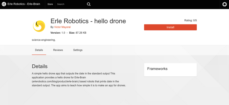
erlerobotics-hello drone

With Erle-Copter’s Ubuntu edition one can install drone apps (behaviors) using any device with a browser connected to the drone. Programming drone apps is done through the Robot Operating System (ROS).

“In a few years ROS has changed the robotics field. It has unified Universities and industry around the world, enhanced collaboration, sharing of algorithms and reuse of code. A task that traditionally could take months can be developed within days using ROS. We are true believers of this framework and its possibilities for the future of robotics thereby adopting it as an SDK for robot and drone app development is the right choice for us.” – Víctor Mayoral Vilches, CTO of Erle Robotics.

The Robot Operating System will delivered in Snappy as installable framework for Erle Robotics drones and robots. Developers will be able to build applications using ROS and put their algorithms in the app store.
Erle Robotics open platform aims to attract innovators and experts to collaborate and compete with open drones and robots for education, research and invention. The drone will be shown at IoT World during this week.

Read more…
3D Robotics

3689650215?profile=originalFrom Maritime Executive, via sUAS News:

This week two major associations representing tour operators in the Arctic and Antarctic respectively, have stated that they will not allow visitors to bring recreational Unmanned Aerial Vehicles (UAV) into the regions.

The International Association of Antarctic Tour Operators (IAATO) reached an agreement at its 26 Annual Meeting to forbid the use of the devices for the 2015-16 season. Similarly, the Association of Cruise Operators (AECO) announced today that they will be banning UAVs as well.

The popularity of the flight and camera systems have grown dramatically in the last several years due to the fact that the devices are generally lightweight and inexpensive. Many tourists use the devices to capture photographs and videos of the surrounding landscapes. However, the operation of UAVs may lead to increased noise pollution, disturbances to wildlife and may interfere with scientific work.

AECO said in an online news release that, “Travelers to pristine Arctic areas enjoy unique nature and wildlife experiences, remoteness and silence. AECO finds that some of these values may be at risk if the general use of UAVs is allowed to continue to increase in the Arctic.”

Additionally, any systems weighing it at under 22kg (55lbs) do not require any type of operator certification. This has raised concerns regarding potential pilot errors resulting in lost vehicles or damage to protected areas.

The ban on UAV extends only to use for recreational purposes. IAATO further stated that its ban will be reviewed next year to allow for changes in UAV regulations as well as potential technological advances.

Read more…

SAM_2374.jpg?width=600

Hello all

In middle of March we went to map the newly formed lava in Holuhraun Iceland, the biggest lava flow in Iceland for the last 200 years with a size of about 80 km^2 (same size as Reykjavík the capital city of Iceland). The eruption did get some media attention, for example Good Morning America had a live broadcast from the eruption and Discovery Canada made a video about the Scientists working there.


 Me and my friend are operating a UAV service here in Iceland and were lucky enough to be invited with the scientist from the Institude of earth sciences at the University of Iceland to map this newly formed lava only two weeks after the eruption stopped. The area is still closed and only open for scientists with a special permission. IMG_7921.jpg?width=300The results were stunning and the amount of data we were able to gather with our UAV mapping platform was tremendous. It is very interesting to compare this method with older methods of mapping with a GPS on the ground and only gathering few hundred measured points in one day while this method record millions of points. The scientists do belive that this area will change quite a lot in the coming years and the craters could possibly collapse.

SAM_2183.jpg?width=300

Of course we are using APM for our mapping platform but the UAV we used was built by our self. From the images we created a 3D model of the Lava field and in the video below you can enjoy flying through this new landscape. The 3D model is from the craters and the lava river that once did stream from the craters is quite obvious to in this 3D model.

We did get some attention of the media here in Iceland.

For this project we used a custom built Skyhunter with APM autopilot and PIX4D to generate the 3D model. We did make special ground control flags that can be seen on the image above. All the flags were measured with a RTK-GPS.

SAM_2330.jpg?width=500

All this was made possible by the clever minds on this forum so thanks to all!

Read more…