All Posts (11069)

Sort by
3D Robotics

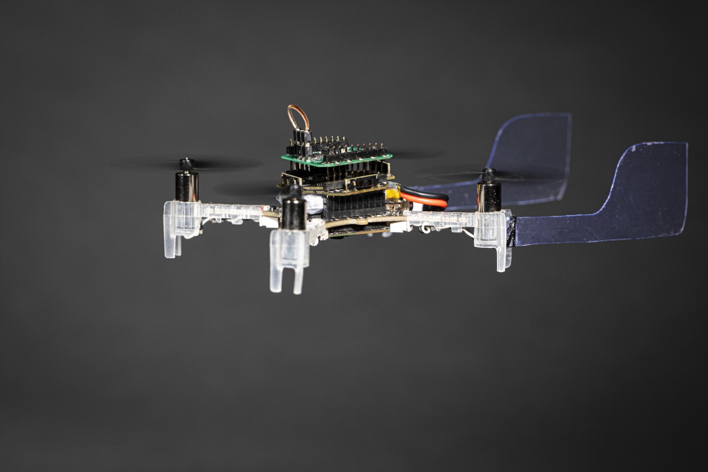
Clever research from ETH showing how it uses the drone camera to maintain position while a quadcopter spins to maintain control after one motor fails. 

From DroneDJ:

Researchers at the University of Zurich and the Delft University of Technology have been able to keep a drone flying after a motor fails. The researchers have managed to use onboard cameras to keep the test drones in the air and flying safely.


AD


team of researchers has come up with a simple yet ingenious way to solve a problem that will usually result in a drone falling to the ground due to a motor failure.

Well, motor failures don’t often happen, but when they do, the drone needs to stay in the air regardless, especially if people are nearby or the drone is being used for a commercial job. Redundancy is important when it comes to drones.

Davide Scaramuzza, head of the Robotics and Perception Group at UZH and of the Rescue Robotics grand challenge at NCCR Robotics, shared:

When one rotor fails, the drone begins to spin on itself like a ballerina. This high-speed rotational motion causes standard controllers to fail unless the drone has access to very accurate position measurements.

Scaramuzza essentially says that the standard controllers in drones cannot cope with the fast and random spinning of a free-falling drone. This led the team to onboard RGB cameras and event cameras, which we’ve gone into in the past for obstacle avoidance.

GPS methods were also explored before the cameras, but the researchers ended up dumping the idea as GPS isn’t available in all situations, especially when it comes to specific drone missions.

The changes between the frames

Now for the way to keep the drone flying. The team equipped a drone with an RGB camera and an event camera. The standard RGB camera detects movements in the whole frame, where the event camera detects changes on the pixel level, allowing for tiny changes to be spotted.

The data from the two cameras are combined using a specially developed algorithm that then tracks the quadcopter’s position relative to its surroundings. This allows the flight controller to take control of the drone as it spins and flies.

Both cameras work great in well-lit environments, but the RGB camera begins to suffer as light decreases. In testing, the researchers were able to keep the drone stable with the event camera all the way down to 10 lux, which is about equivalent to a dimly lit room.

Video Player
 
Read more…

Zion Market Research has published a new report titled “Drone Logistics and Transportation Market By Solution (Shipping, Warehousing, Software, and Infrastructure), By Drone (Passenger, Freight, and Ambulance), and By Sector (Commercial and Military): Global Industry Perspective, Comprehensive Analysis, and Forecast, 2018–2025”. According to the report, the global drone logistics and transportation market was USD 4.56 billion in 2018 and is expected to reach around USD 18.05 billion by 2025, at a CAGR approximately 21.9% between 2019 and 2025.

8422565492?profile=RESIZE_710x

Unmanned aerial vehicles, also known as drones, are small aircrafts that don’t have a human pilot onboard that can either operated remotely or automated and travel with the help of GPS coordinates. They are made of light material to reduce weight, which enables them to fly at high altitudes. Drones are controlled by a ground cockpit and can easily return to their marked starting position in case of low battery or when the drone loses contact with the controller. Initially, these were used for photography and videography; however, these are used for applications in the supply chain of the modern world. Drones are considered to revolutionize the supply chain.

In this constantly evolving world, entrepreneurs and visionary leaders are focusing on integrating drone delivery in the supply chain. This is the primary growth factor of the drone logistics and transportation market, as including drones in the supply chain is believed to revolutionize the way shipments reach the customers. It will be the fastest way to transport and has the potential to deliver orders within minutes. Drones will have a diverse range of impact on the supply chain. Drones can track inventory and act as a significant system for inventory management, which will reduce the inventory carrying the cost of companies. Around 90% of the inventory of a warehouse is stationary and companies end up with extra inventory due to improper management. However, it is often difficult even for planes to fly in extreme weather conditions like snow, rain, and strong winds. Drones are smaller versions of these flying machines and could pose a major challenge for delivery during extreme climatic conditions, which might imply that drones can deliver only in certain climatic conditions. This is a major restraint for the drone logistics and transportation market.

By solution, the shipping sector is expected to hold the highest market share. Drone shipping has been targeted by various companies like Amazon, Google, UPS, DHL, etc. By drone, the ambulance drone segment will hold a major market share, owing to the increasing casualties and growing traffic congestion in major cities across the globe. The first few moments are the most crucial during an accident to prevent any further escalations. Lifesaving technologies like CPR (Cardiopulmonary Resuscitation), medication, and AED (Automated External Defibrillator) can be made compact enough to be performed by a drone. Moreover, drones can also transfer other crucial medical supplies during disasters and across tough terrains.

Download Free Research Report Sample PDF for more Insights - http://bit.ly/3oWtyz3

North America will hold a substantial share of the drone logistics and transportation market in the future, owing to the various developments and innovations witnessed in the inventory management domain. The U.S. is witnessing continuous growth in tech start-ups every year, which is backed by numerous venture capitalists, thereby increasing the regional market scope. The presence of key market players is also predicted to accelerate the demand for drone logistics and transportation market. In Europe, the presence of developed economies of the UK, Germany, and France is contributing to the drone logistics and transportation market.

Some major key players operating in the drone logistics and transportation market are PINC Solutions, Matternet, Drone Delivery Canada, Hardis Group, CANA Advisors, Infinium Robotics, Workhorse Group, Aerovironment, DroneScan, Skycart, and Zipline.

Read more…

The main focus of this research is to develop a real-time forest fire monitoring system using an Unmanned Aerial Vehicle (UAV). The UAV is equipped with sensors, a mini processor (Raspberry Pi) and Ardu Pilot Mega (APM) for the flight controller. This system used five sensors. The first is a temperature sensor that served to measure the temperature in the monitored forest area. The others sensors are embedded in the APM. There are a barometer, Global Positioning Sensor (GPS), inertial measurement unit (IMU) and compass sensor. GPS and compass are used in the navigation system. The barometer measured the air pressure that is used as a reference to maintain the height of the UAV. The IMU consists of accelerometer and gyroscope sensors that are used to estimate the vehicle position. The temperature data from the sensor and the data from GPS are processed by the Raspberry Pi 3, which serves as a mini processor. The results of the data processing are sent to the server to be accessible online and real-time on the website. The data transmission used the Transmission Control Protocol (TCP) system. The experimental setup was carried out in an area of 40 meters × 40 meters with 10 hotspots. The diameter of the hotspots is 0.4 meters with a height of 0.5 meters. The UAV is flown at a constant speed of 5 m/s at an altitude of 20 meters above the ground. The flight path is set by using a mission planner so the UAV can fly autonomously. The experimental results show that the system could detect seven hotspots in the first trial and nine hotspots in the second trial. This happened because there is some data loss in the transmission process. Other results indicate that the coordinates of hotspots detected by the UAV have a deviation error of approximately 1 meter from the actual fire point coordinates. This is still within the standard GPS accuracy as this system uses GPS with a range accuracy of 2.5 meters. 

You can Download this article on Research Gate or Journal of Engineering Science and Technology

Read more…

The main focus of this research is early detection system for forest fires by using Unmanned Aerial Vehicle (UAV). Data source of fires are collected by mobile devices such as GPS-equipped UAV quadcopter, non-contact infrared sensor, and the sensor stabilizer. The data from sensor is sent via telemetry link 433 Mhz, towards the Ground Control Station. Then the data is processed by a program that has been made, namely SPTA Real-time v0.1.0, which can show the temperature data as well as the color layer based on the difference of temperature levels in real-time on a digital map layer. The coordinates of fires are observed by SPTA realtime v0.1.0, and then it is compared with the coordinates of the source of the fire that is recorded manually. The results of data retrieval, the area that monitored is 3662 m2, constant height of 30 m, quadcopter speed of 5 m / s. First Data, with wind speeds of 3.2 m / s has a difference of 1.18 m from the coordinate source of the fire, within GPS tolerance accuracy is 2.5 m. For the second data with a wind speed of 6 m / s, has a difference of 5.16 m from the coordinates of the source of fire, deviated from the tolerance is 2.66 meter GPS accuracy.

You can download DEVELOPMENT OF UNMANNED AERIAL VEHICLE FOR REAL TIME FIRE FOREST DETECTION.pdf


Read more…

Long Range

I left the tittle wide open intentionally.  This is something that is beyond my skills.  One of the things that we all struggle with.  If you want two cameras, you have to have two transmitters or switch betwen them.  Telemetry from your autopilot, can get some of that from the OSD butr to update the autopilot, you need another tranciever  that you can also use for telemetry sometimes.  Then you need the reciever for the remote control stuff.  OK Thats two transmitters, one transciever that really doesn't have good range and a reciever.  All of this back and forth is data.  Some analog some digital.  What I am hoping to throw into the hornets nest here is an idea that I'm hoping the community can take and run with it.  What I'm proposing is using 802.11n  Not g or ac but n.  Reason, most of the wireless service providers are using n to distribute their product, internet connection.  With n you have a range that is in quite a few miles with excellent bandwidth. An 802.11n tranciever can be had in a wide rante of power and cost.  Both the base station and drone mounted unit can be of the same make and power.  Then the output of the tranciever is IP.  That can be decoded by something as a Raspberry Pi and then your cameras and load of stuff can be interfaced vie usb and other ports on the board.  There are only two usb ports on a Pi but a usb expansion board can be used.  Going this rout the amount of data transfered between your base station and the drone is much much broader.  The very design of the 82.11 tech allows for several to many trancievers sharing the space allowing for a coaperative operation of data and this can cut down on interferience. Like when you use an analog video link, ANY transmitter on the same channel can cause havoc and possibly even loss of video.  802.11 is designed to deal with other in the area and will deal with it by design.  So, my tech geniuses let the creativity begin.

Read more…

Enterprises & Startups can leverage FlytNow APIs to build & scale automated, cloud-connected drone applications, and reduce time-to-market.

The commercial drone industry is heading towards complete automation. This transition calls for seamless integration with different software & hardware. At FlytBase, we are cognizant of this ever-growing need for scalable enterprise applications that involve drones. Keeping this in focus, we are introducing FlytNow API platform to enable automated, cloud-connected drones applications for enterprises & startups.

We are proud to announce that we are extending the capabilities of FlytNow as a comprehensive backend platform for enterprise drone ops. We introduce FlytNow APIs to securely connect drones with any type of business application that supports RESTful architecture. This means that businesses can rapidly build and scale custom drone applications to manage their drone fleet.

Key benefits of using FlytNow APIs

  • Simple: FlytNow APIs are simple with clearly defined endpoints to perform specific functions.
  • Powerful Abstractions: FlytNow APIs provide powerful abstractions so developers do not have to deal with lower-level languages to communicate with drones.
  • Hardware Agnostic: Whether it is a DJI, PX4, or ArduPilot drone or any companion computer (like Rasberry Pi 4b, Nvidia Jetson, ODROID N2, etc.), FlytNow APIs are agnostic and have the necessary adapters to communicate with the hardware. These APIs
  • Discoverable: Our API endpoints are logically organized in extensive documentation so that even new developers can get up to speed quickly with the capabilities.
  • Consistent: All our API endpoints are constructed logically so that developers can anticipate different functionalities.
  • Virtual Drones: As the name implies, these are simulated drones in a virtual environment. Work on simulations to test your applications faster without risking expensive hardware.
  • Scalability: Our cloud services are hosted on Amazon AWS, and it is adaptive making it possible to deploy resources as you grow your business.

APIs that are currently available for our enterprise users


  • Navigation APIs: Control drones remotely from a dashboard.
  • Telemetry APIs: Fetch telemetry data like speed, altitude, global position, etc. from a drone.
  • Payload APIs: Control & integrate various payloads with FlytNow.
  • Video Streaming APIs: Access live video streaming from a drone. Share this stream with your team and guests for collaboration.
  • Vehicle Setup APIs: Perform a series of checks on the operational capabilities of a drone.
  • Gimbal Control APIs: Remotely control the gimbal pitch of a drone.
  • Camera Zoom APIs: Change the orientation of the camera and the zoom remotely.
  • Command & Control APIs: Send drone to a GPS location, control heading remotely.
  • Mission Planning APIs: Set a pre-programmed mission/path for a drone.
  • Precision Landing APIs: Land drones precisely on a machine-generated tag.
  • Collision Avoidance APIs: Integrate collision sensor data with FlytNow dashboard and set thresholds to avoid collisions.
  • Drone-in-a-box API: Integrate with Drone-in-a-Box hardware. Command drone launches and landings remotely. Moreover, you can retrieve charging (or battery swapping) & docking station statuses.
  • Geofence APIs: Set a virtual boundary for drones and trigger fail-safes in case of breaches.

What enterprises & startups can build using our Drone APIs

Drone-based autonomous security and surveillance system:


Security systems can be enhanced using drones. A custom enterprise web application can be integrated with CCTV cameras & software (for example Video Management solutions like Milestone), motion sensors, and ground-based hardware using FlytNow APIs. Further, businesses can leverage these APIs for mission planning to automate the patrolling of drones, thereby reducing the need for redundant manpower. Automation need not be limited to just spontaneous patrolling; it can be scheduled for regular security patrols using APIs for DiaB (Drone-in-a-Box hardware). Absolute autonomy lies in eliminating human interference starting from time-defined missions where the drone takes off, performs the mission, and docks back into the box to charge/swap batteries. In real-life, the system will leverage a unified dashboard as a command center and our live video streaming APIs to manage the entire operation. In the event of an intrusion, it will operate in the following way:

  • An intrusion alert goes off in the main dashboard. API integration with FlytNow triggers the drone system.
  • The system creates a waypoint mission for the drone. A drone automatically launches from a DiaB station and goes to the point of interest.
  • The drone begins live-streaming, and the human operator identifies the intruder from the live drone footage. The operator uses the payload APIs of FlytNow to maneuver the camera and look around. AI-detection technology can also automate intruders and help track in the video.
  • On completion of the mission, the drone automatically returns back to the docking station.

Drones-based medical delivery system:


Companies have been actively building & deploying drone systems that can deliver critical medical payloads to remote locations. A US-based company called Zipline is one such company that has extensive operations in the African nations of Ghana and Rwanda. They rely on a centralized system where they operate from a medical warehouse and all incoming requests for blood are fulfilled via drone delivery. The highlights of the system are that the drones can fly autonomously from the warehouse to the delivery point, drop the payload, and return back to the base. Following are some APIs of FlytNow can be used to build a similar system:

  • Mission Planning APIs: To set the route of a drone to the delivery location.
  • Navigation APIs: To take control of a delivery drone remotely in case of an emergency.
  • Vehicle Setup APIs: To run a diagnostic of a drone before sending it off to a mission.
  • Video Streaming APIs: To remotely monitor a delivery mission through a video feed.
  • Geofence APIs: To restrict the area of operation of the drones.
  • Command & Control APIs: Send drone to a GPS location, control heading remotely.
  • Collision Avoidance APIs: To get data from the onboard sensors and set thresholds to avoid collisions.
  • Payload API: To control the payload dripper or actuators

Drone-based emergency response system:


Leveraging the FlytNow APIs, a response system can be built that is fully autonomous and integrated with a Computer Aided Dispatch system like 911. In the event of an emergency, an operator using such a system can dispatch a drone to survey the situation. On receiving the command, a drone will launch and fly to the location autonomously and begin acquiring data using its onboard camera. The operator can share the live feed of the drone with the first responders who can plan a better response.

The APIs used in this case would be similar to the delivery system mentioned above, with a focus on BVLOS capabilities and live-stream of data.

Summary


In this blog, we introduced the APIs of the FlytNow platform and the benefits of using them. In a nutshell, FlytNow is built for developers building applications to manage enterprise drone operations with BVLOS capabilities. Our extensive and reliable set of APIs is a result of our experience working with commercial drones for almost a decade. Originally published on FlytNow

Read more…

M-Eagle A2 long endurance vtol drone

M-Eagle A2 long endurance vtol drone equips with Herelink 2.4Ghz HD video transmission system, which is an all-in-on data video and rc system with max range 20km.
Max payload 1kg, sony A7R mapping camera, 10x zoom dual sensor camera and multispectral camera are recommended.
With Zeus Power 30000mah sem-solid battery, max endurance can ben 2 hours(no payload). 
#Vtol drone #Long
 range uav, mapping drone8268879890?profile=RESIZE_710x8268880299?profile=RESIZE_710x8268880670?profile=RESIZE_710x8268880693?profile=RESIZE_710x8268881061?profile=RESIZE_710x8268907894?profile=RESIZE_710x

Read more…
3D Robotics

From NewAtlas:

No matter how good we humans have made something, chances are nature did it better millions of years ago. Rather than compete, it’s often better to tap into the natural version – and that’s exactly what scientists have done with the Smellicopter, a drone that uses an antenna from a live moth to sniff out its targets.

We humans don’t tend to rely on it too much, but to moths, the sense of smell is crucial. They use their feathery antennae to scan for the smell of flowers, mates, and other important things, so they’re incredibly sensitive – a single scent molecule can trigger a cascade of cellular responses, very quickly.

Realizing that, engineers at the University of Washington hooked up an antenna from a live moth to a suite of electronics, and used it to guide a drone towards specific scents. They call the end result the Smellicopter.

“Nature really blows our human-made odor sensors out of the water,” says Melanie Anderson, lead author of the study. “By using an actual moth antenna with Smellicopter, we’re able to get the best of both worlds: the sensitivity of a biological organism on a robotic platform where we can control its motion.”

The antennae are sourced from the tobacco hawk moth, which are anesthetized before removal. Then, small wires are inserted into each end of the hollow antennae, which can measure the average signal from all of its cells. The antenna only stays biologically and chemically active for up to four hours after being removed from a live moth, but the researchers say this could be extended b storing them in the fridge.

The Smellicopter is a drone that uses a live moth antenna as a smell sensor The Smellicopter is a drone that uses a live moth antenna as a smell sensor
Mark Stone/University of Washington

To test out the cyborg’s smelling prowess, the team placed it at the end of a wind tunnel, and had it compete with a standard artificial odor sensor. When either a floral scent or the smell of ethanol was wafted down the tunnel, the antenna reacted faster than the other sensor, and was able to cleanse its palette quicker between smells.

For the next experiments, the researchers then mounted the electronics onto a small, common quadcopter platform, which was equipped with two plastic fins to keep it oriented upwind, and four infrared sensors for obstacle detection and avoidance.

Finally, the Smellicopter was driven by an algorithm that mimicked how moths search for smells of interest. The drone starts off by drifting to the left for a set distance, and if it doesn’t detect a strong enough scent, it then moves to the right for a while. When it detects a smell, the drone will then fly towards it. If at any point those infrared sensors pick up an obstacle within 20 cm (8 in), the Smellicopter will change direction.

“So if Smellicopter was casting left and now there’s an obstacle on the left, it’ll switch to casting right,” says Anderson. “And if Smellicopter smells an odor but there’s an obstacle in front of it, it’s going to continue casting left or right until it’s able to surge forward when there’s not an obstacle in its path.”

The team says the device could be useful for seeking out plumes of scent, such as chemical signatures from explosives or the breath of people trapped in rubble. That way, the drones could help in situations where it may be dangerous to send humans to investigate. And it might not be the only insect hybrids doing so – other studies have experimented with using cyborg cockroachesdragonflies and locusts for similar purposes.

The research was published in the journal IOP Bioinspiration & Biomimetrics

Read more…

BatMon enabled Smart Battery available for purchase

8249073295?profile=RESIZE_710x

You can now buy BatMon enabled smart batteries off the website, saving you the engineering time for assembling your own. 

BatMon enabled batteries can talk with Ardupilot, Pixhawk, Arduino and ROS. BatMon enables safe and robust operation of robot using smart batteries. Batteries are currently shipped ground within contiguous United States.

Smart Battery features

  • 2-12S LiPo/Li-Ion Battery support
  • SMBUS based data protocol. Work out of the box with Ardupilot, Pixhawk*, Arduino, Raspberry Pi etc
  • 150A burst/ Optional 240A burst
  • Accurate current monitoring 
  • Accurate individual voltage monitoring
  • OLED screen for monitoring and outdoor viewing
  • Buzzer usable for warning
  • Firmware upgradeable with optional programmer

Buy Smart Battery 6S 4500mAh

Get custom BatMon enabled Smart Battery

8249074493?profile=RESIZE_710x


Read more…

Customizable open source smart charger (2-12s) : BatCha

8233112655?profile=RESIZE_710x

We built BatMon for making smart batteries. BatMon can now talk with Ardupilot, Pixhawk, and ROS and enables safe and robust operation of robot using smart batteries. But there is a missing piece, a smart charger that can safely charge batteries with a peace of mind for customers.

So, we are building exactly that, and a lot more, to future proof your workflow as they scale. Below is a sneak peek of the most foolproof futureproof smart charger we know of: BatCha

BatCha features

  • Opensource Firmware
  • 2-12S LiPo Charge
  • Smart battery data interfaces:
    • I2C: Two wire based protocol such as SMBUS
    • CAN BUS: Two wire differential pair robust protocol for UAVCAN, CANaerospace etc
    • LIN BUS : Single wire communication protocol for micro drones
  • Two ports. Charge two battery simultaneously.
  • 500 watt total power. Shareable to either ports
  • Max charging current per port: 20A
  • Measures battery temperature and voltage for safe charging limits for each battery
  • Optional: expansion puck to charge 4x smart batteries per port
  • Optional: Puck for 2-12S dumb battery charging and balancing
  • USB interface for monitoring and controlling charge workflow from PC
  • Optional: Integrated Raspberry Pi Compute module for Wi-Fi and Ethernet connectivity
  • OLED screen for monitoring and outdoor viewing
  • User Interface engineered for speed and safety. Plug-in to charge-start in less than 4 seconds
  • Zero effort to train customers on battery charging and safety. Customer have two options: Regular charging / Fast Charging
  • Mechanical design optimized for robustness and repairability

Sign up here for more details.


Read more…

Rpanion-server 0.7 Released

8183230679?profile=RESIZE_710xRpanion-server 0.7 has been released!

Rpanion-Server is an Open-Source software package for a managing the companion computer (such as the Raspberry Pi) connected to an ArduPilot or PX4 flight controller. It will run on most Linux-based systems.

Rpanion-Server consists of a network manager, MAVLink telemetry routing, flight logging and a low latency video streaming server. All can be managed via a web-based user interface.

Documentation and pre-built disk images for the Raspberry Pi are available at https://www.docs.rpanion.com/software/rpanion-server. Source code is at https://github.com/stephendade/Rpanion-server

New in 0.7 is:

  • Support MJPEG cameras for video streaming
  • Added button to disable all Wi-Fi adapters
  • GUI overhaul, using the Bootstrap framework
  • Various bug fixes


Read more…

Mavlink3DMap

Mavlink3DMap is a semi-simulator that communicates with Ardupilot SITL vid  UDP and websockets to plot vehicles location and attitudein a 3D environment. It uses HTML, javascript and some 3D and physics libraries to work. The world semi is used because this tool can integrate with any Ardupilot SITL  regardless of its engine, and read vehicles location and plot it in a 3D environment. So all physics and logic computation are performed by SITL. However, one can add 3D objects and some physics using moderate developing effort. The tool can also track multiple drones given each drone has its own SYSID_THISMAV


Below is the famouse flying field in Australia where SITL flies there by default. As we can see the map is displayed in 3D, and from multiple views. A camera is attached to drone and can be controlled via buttons. Another camera is following the drone.

8182289656?profile=RESIZE_710x

The above map uses flat landscape, i.e. the map is created on a 2D Plan, but the environement is a 3D environment.

The below image shows one step forward, it creates 3D mesh of the map and adjust drone absolute altitude accordingly based on drone home location.

8182331255?profile=RESIZE_710x


This project is in its very early stage, it is free and open-source and can be accessed here. I hope people start to use and contribute to it.


Read more…

To simulate the practical applications of Sky Fury VTOL, such as mapping, search, rescue, or surveillance. YANGDA made one testing and recorded the whole flight.

Test records:
* Battery: 2x Tattu 25000mAh 6S1P lipo batteries
* Payload: 1.2KG iron block
* Weather: Cloudy to light raining
* Flight mode: Auto at 300m radius
* Voltage when take-off: 52v
* Voltage when landed: 44. 1v
* Flight time: 202minutes
  
Read more…

The threat from physical intrusion still remains one of the top concerns in both commercial and non-commercial contexts. According to a report from Markets and Markets, the video surveillance market, which includes both hardware and software, is presently at USD 45.5 billion and expected to reach USD 74.6 billion by 2025.

Over the years, there have been many advancements in optics and detection systems but limitations still exist in the conventional ways of using them. To overcome these limitations, security stakeholders are now incorporating drone technology in their operations.

In this blog, we will talk about drones and the FlytNow solution for perimeter security.

What is perimeter security?

automated perimeter security

Perimeter security is an active barrier or fortification around a defined area to prevent all forms of intrusion. Modern security systems are an amalgamation of sophisticated hardware and software that generally include cameras, motion sensors, electric fencing, high-intensity lights, and a command center to manage them all. 

Challenges with conventional security systems (without drones) for perimeter security

Below are some of the drawbacks and limitations that are inherent in a conventional security system:

  • CCTV cameras and motion detectors are stationary, thus leaving plenty of room for blind spots.
  • Patrolling requires human guards - for larger areas, this is the least efficient way of securing a premise.
  • Response to an intrusion is delayed since a human responder has to reach the location.

Benefits of using drones for perimeter security

Drones have the following advantages over a conventional security system:

  • Drones are mobile flying machines that can go to any location quickly, with HD camera(s), thus eliminating blind spots.
  • Drones can also be equipped with a thermal camera(s) which are useful during nighttime surveillance.
  • Drones can be automated for patrolling using the FlytNow cloud-connected solution and commercially available DiaB (Drone in a Box) hardware.

Note: A DiaB is box-like hardware that houses one or more drones. The hardware keeps the drone flight-ready (24x7) and also automates the launching and docking processes of a drone.

Drones automation for security

For perimeter security, drones are generally used in conjunction with Drone-in-a-Box hardware and a fleet management system that powers the command center. Other security system hardware, including CCTV cameras, motion sensors, etc. can complement the drones and can be connected to the command center, thus integrating into a complete system. In a real-life scenario, such a system might work in the following way:

Drone Command Center

  • An intrusion is detected by one of the CCTV cameras in an area under surveillance. 
  • The command center receives the alert and initiates a drone launch. 
  • A connected DiaB receives the launch request and releases a drone. 
  • The drone flies to the location where the intrusion was detected and begins streaming a live video feed. 
  • An operator maneuvers the drone to cover all blind spots.
  • On finding the intruder, the operator has the option to warn him/her about the transgression using the drone’s onboard payload such as a beacon, spotlight, speaker, etc.

To know about the kind of drones and sensors that can be used for security and surveillance operations please refer to our Drone Surveillance System: The Complete Setup Guide.

How FlytNow enabled perimeter security?

FlytNow is a cloud-based application that helps in managing and controlling a fleet of drones from a unified dashboard through automation, live data streaming and integration. In the context of perimeter security, this translates into a command center that connects drones with the traditional components of a perimeter security system.

6 Reasons to use FlytNow for perimeter security

#1 Easy Setup: FlytNow is cloud-hosted i.e. a user can access the application from any standard web browser, without any complicated server setup. Connecting the drones with the system is also easy and is done using FlytOS.

#2 Unified Dashboard: FlytNow features an advanced dashboard that shows the following:

  1. A live map showing the real-time location of all the drones. The map can be customized to show points of interest, and virtual geofence, and CCTV zones.
  2. On-screen GUI controllers and keyboard & mouse support to control a drone. This allows an operator to easily maneuver a drone to a point of interest from the command center.
  3. Multicam support that allows streaming video feeds from more than one drone.
  4. Different view modes that allow an operator to switch between RGB and thermal mode. In the thermal mode, there is the option to switch between different color pallets, allowing a user to identify warm objects against different backdrops.
  5. Pre-flight checklist which is a list of checks the system prompts an operator to perform before initiating a drone launch.

#3 Live Data Sharing: An operator can share the live video feed from a drone directly from the dashboard. The feature can be used to share video with the police or other remote stakeholders.

Using Drones for Perimeter Security

#4 Advanced Automation: Operating drones through manual control is quite an inefficient way to use drones. Instead, automation should be employed to perform activities like security patrols. FlytNow comes with an advanced mission planner that allows a user to define a path for a drone to follow and save it as a mission. The mission can be executed periodically, thus making a fleet of drones perform automated patrolling.

FlytNow for perimeter security

#5 Add-on Modules: FlytNow provides add-ons to make a drone intelligent; this includes precision landing over a computer-generated tag, obstacle detection, and object identification. These add-ons enable a drone to autonomously fly to a location, identify a threat, and return to the DiaB hardware.

#6 Drone-in-a-Box Hardware Support: The functions of DiaB hardware, in the context of perimeter security, can be broadly classified into four categories:

  1. Securely house a drone.
  2. Keeping the drone fully charged all the time.
  3. Initiate a drone launch.
  4. Successfully dock a returning drone.

Summary

In this blog, we discussed the concept of perimeter security, the limitations of conventional security set up, and how these limitations can be overcome using drones. Then we covered how drones are actually used for aerial patrols and 6 reasons why FlytNow is an ideal solution for automating drones for perimeter security.

There are plenty more reasons to use FlytNow for perimeter security that you can find out by signing for our 28 days free trial.

Read more…

Weed whacking robot


Took a while to remember who Helen Greiner is/was.  She was a founder of irobot.  She bounced around the quad copter startups when that was big, but now has landed at a weed whacker startup.  It has a simple string trimmer on the bottom which chops a weed, but it doesn't suck them into a vacuum bag.  Theoretically, chopping off the weed is enough to deal with the problem.

The problems is has to solve are getting around uneven dirt without falling over or getting stuck, differentiating plants from weeds.  It uses capacitive sensors to navigate around taller plants. Plants which impinge on the capacitive sensors cause it to turn.  

The string trimmer runs slowly to detect shorter plants.  Plants which are short enough to pass under the robot & impinge on the string trimmer are treated as weeds & cause the string trimmer to spin up.  There are ways to make it avoid short plants by erecting metal barriers.  It has to be waterproof.  There's no lidar.  It manages to generate all its power from a solar panel.  

Basically not much more than what a $50 toy used to do, but in the QE world now valued at $400.  It's the epitomy of a minimally viable product which they hope to bootstrap off of & improve upon.  For those of us without the $25 million for a back yard near a job market, the most useful part may be the traction system for navigating around dirt.  It's surprising those goofy diagonal wheels would make any difference.

8128924299?profile=RESIZE_710x


Read more…

8079589295?profile=RESIZE_710x

BatMon is a module that connects to you batteries to "smartify" them. BatMon reads the cell voltage, current and relays it to autopilot or the onboard computers. We made a quite a bit of improvements in the latest v3 devkit. The most important is the support for 3 different protocols :

  • SMBUS(I2C based two wire protocol)
  • CAN (CAN based differential two wire protocol) 
  • LIN (a robust single wire data communication protocol invented for automotive application)

SMBUS is currently supported in the stock firmware. We have added support for Ardupilot, Pixhawk and Raspberry Pi (ROS) environment. 

8079080684?profile=RESIZE_710x

The features of Batmon are: 

  1. Inbuilt Coulomb counting for accurate power draw (and State-Of-Charge) for the pack
  2. Accurate monitoring of individual cell voltage ( precise to 50mV ) 
  3. Onboard temperature monitoring + extra optional temperature probes for accurate measurement of battery temperature in harsh weather.
  4. Stock firmware connects to Pixhawk, Ardupilot, Raspberry Pi (ROS) 
  5. Onboard cell balancing
  6. Switchable low-power LED indicators display for convenient display of battery SOC
  7. Optional OLED display and warning buzzer
  8. Optional safety cutoff FET

The first batch of boards are available for pre-order till Oct 31 here: https://rotoye.com/batmon/

Read more…

How Drones are Useful in Forest Fire Response

Unmanned Aerial Vehicles (UAVs) are already in use for controlling fires in urban areas and places where people reside. These UAVs are usually quadcopters that are quite effective in hovering in one place.

In the event of a fire, the primary objective of using drones is to gather situational awareness, which can be used to direct the efforts of the firefighters in locating and controlling hot spots.

Just like urban fires, forest fires too require monitoring so that firefighters know what they are dealing with.

Forest fires are different from urban fires; they are hard to control (sometimes cannot be controlled) and pose a greater threat to people and property. Here, drones can play a crucial role in detecting, containing, and extinguishing forest fires.

One example of drones to combat forest fires is that of California National Guards, who are using MQ-9 Reaper (military reconnaissance drones) to assist emergency responders in controlling forest fires. They have already provided crucial assistance in massive forest fires, which include Mendocino Complex Fire and Carr Fire.

Before we dive into how drones are used in this context, it is important to understand why they are used.

Why Drones are Used in Controlling Forest Fires?


In the event of a forest fire, time is of the essence. This is why it makes sense to use a drone for two primary purposes: initial detection and initial rescue. Here is a further breakdown:

  • Drones can quickly be airborne, fly to a location, map the area affected by the fire, and share the information to all relevant agencies within a couple of minutes.
  • A drone can carry a whole range of sensors, including a thermal camera that supports multiple color pallets. The combination of all these sensors provides a better picture of the spread and speed of the fire, which can help civil authorities to come up with a relief plan.

How Are Drones Used in Forest Fires?


Drones are useful especially in forest fires that are difficult to control. They are primarily used for collecting information and during post-incident recovery. Their usage can be explained as follows:

Information gathering: During a forest fire it is important for firefighters to know whether they are hitting the hot spots, which is difficult and dangerous for the ground crew since such fires tend to spread over a large area.

Here drones carrying a thermal camera can do the job much more efficiently. A pilot flying a drone can cover a large area and identify hot spots using the thermal camera. Thermal cameras like DJI Zenmuse XT offer multiple color palettes that can precisely identify hot and cold zones giving a better idea of the kind of temperatures the responders are dealing with.

Learn how DEEP (The Department of Energy and Environmental Protection) has been using drones to combat forest fires.


Aid and protection: Fighting any kind of fire is an occupational hazard for firefighters. But forest fires can move in any direction depending on the wind. This means a firefighter on the ground fighting a forest fire without the knowledge of the spread can easily get trapped.

The footage captured by a drone can provide insights about the spread and direction of the fire. This information can protect firefighters from going too close to the inferno.

Terrain Mapping: Footage captured from a drone can be converted into a 3D map allowing civil authorities to ascertain the extent of the damage. This information is useful during post-incident relief work and for insurance companies to verify damage claims.

Real-time Awareness: Any kind of relief work requires resources, and for that situational awareness is required for planning. In 2018, wildfire threatened the town of Hechingen, Germany, which was facing severe drought and the water level dropped below 50%.

The fire department of Hechingen was called in to control the blaze. The fire was close to a remote country road far away from water sources and covered an area close to 5000 square meters. DJI M210 drones, with Zenmuse XT and X4S cameras, were put to the test and flown over the area to gather intelligence. Aerial imagery showed the firefighters the hot spots and the spread of the fire; accordingly, they planned to carry water, in fire engines, to the spot and control the blaze.

Thus, drones played an important role in providing intelligence for decision making.

How FlytNow Enhances the Capabilities of Drones Fighting Forest Fires


FlytNow is a cloud-based fleet management solution that provides a unified dashboard for managing a fleet of drones. The dashboard provides access to drone-mission planning, live telemetry, and video streams from all connected drones over a 4G/LTE/5G network. Below is an illustration of how the solution works.

How Drones are Connected to FlytNow?


FlytNow supports a wide variety of drones including the popular DJI Mavic and Matrice series of drones.

Connecting a DJI drone is extremely simple; download and install the FlytOS mobile app and connect the mobile with the RC of the drone. The mobile application acts as a relay between the drone and the cloud application. Live telemetry and the video feed are sent to the FlytNow cloud server over the mobile network.

Custom drones also work with FlytNow by leveraging a single board computer (SBC). An SBC with the operating system is connected to the flight controller of the drone, which communicates with FlytNow either through Wifi or a GSM module.

Establishing a Localized Command Center Using FlytNow Business


FlytNow Business is a standard offering that comes with out of the box features. This solution is ideal for setting up a localized command center to manage drones working to bring a forest fire under control.

A forest fire can burn for days before it’s brought under control, so it becomes important for fire officials to stay close to the situation and monitor it. Following are the features that would allow firefighters to set up a command center and some ways they can be used:

  • FlytNow Business can be accessed from a web browser. A firefighter with a laptop or a tablet can log in to the FlytNow dashboard and see the statuses of all connected drones. Like a command center, he/she can manage and control all drones from a single dashboard.


FlytNow for drone forest fire

  • FlytNow Business comes with an advanced mission planner that allows for setting up a flight path for a drone. Using the mission planner, a fire official can program a drone to fly over a defined perimeter and map it in order to understand the spread of the fire.
  • It can stream live video and telemetry from all connected drones. Using this feature, a fire official can see the video feeds (at ultra-low latency) from all connected drones on the dashboard and even share them with various agencies either via email or using the built-in team management. This would allow for better coordination among different agencies.


fire fighting response team

  • The dashboard supports multiple views for different kinds of operations. For example, in a search and rescue operation, an operator can switch to the IR view to detect the heat signature of people trapped by the fire.


Drones wildfire response

In the case of DJI Mavic 2 Enterprise Dual and Matrice 210 V2 Dual, the dashboard supports MSX, which generates high contrast thermal images with lines and edges, and multiple color palettes including isotherms. Using the color palettes, a firefighter can identify hot and cold regions, which can aid in the identification of hot spots.

Early detection of forest fires

  • FlytNow Business can be integrated with cloud servers like AWS S3 for the storage of video captured during firefighting operations. These videos can later be used for training purposes.

Establishing an Automated Drone Based Response System Using FlytNow Enterprise


FlytNow Enterprise is a customizable offering that includes all the features of the Business version plus additional features. It can be used to set up a fully automated response system that can be integrated with ground-based hardware (Drone-in-a-Box and charging pads) and computer-aided dispatch systems like 911. A system like this would function in the following way.

drones for fighting forest fires

  • An emergency operator receives a forest fire alert through the computer-aided dispatch system.
  • The alert is routed to the nearby fire stations. A fire official logs in to the FlytNow dashboard and selects the alert, which pinpoints the fire’s location.
  • The firefighter requests a drone recon over the area. The response system (powered by FlytNow Enterprise) automatically creates a mission and selects a nearby drone station ( Drone-in-a-Box hardware). FlytNow Enterprise supports all popular Drone-in-a-Box hardware.
  • The drone receives the command and flies off autonomously. FlytNow Enterprise supports integration with UTM service providers like Airmap for airspace intelligence to support BVLOS flights.
  • On reaching the location, the drone starts recording and sends out a live video feed for the firefighter to see.
  • A firefighter has the option to use AI features like object detection to identify certain ground objects, for example, a hotspot.
  • The drone continues the mission until its battery becomes low. It goes back to the station and lands on the DiaB hardware using the precision landing feature by FlytNow Enterprise. The solution makes it safe for the drone to fly autonomously with advanced failsafe that allows a drone to do an emergency landing in case of a hardware failure.

Summary


In this blog, we understood the importance of drones and how they are used in controlling forest fires. We discussed in detail the challenges that drones allow firefighters to overcome, and how FlytNow as a solution enhances the capabilities of drones.

You can implement FlytNow today with our 28 days free trial and see yourself how FlytNow can enhance your workflow with drones. Making the justification of using drones even stronger.

Source:https://flytnow.com/drones-in-forest-fire-response/

Read more…

When we think about commercial drones, we mainly see them as a tool for aerial inspection and monitoring, since a lot of applications happen in this context. According to phillybyair.com, the construction industry was the largest user of drones, in terms of usage, in 2019, which further strengthens the perception of widespread use by this industry. 

However, the COVID-19 pandemic has drastically changed the commercial drone ecosystem; we are now witnessing a rapid adoption of drones by various government agencies across the world for public safety use cases. For instance, during the global pandemic lockdown, police officials in the state of Gujarat, India created the country’s first drone command center from where a fleet of drones was managed to monitor the streets of the city of Ahmedabad; read the full case study

If we dig deeper into the use of drones for public safety, there is one use case that is not often talked about, drones for highway patrolling. No! You won’t be getting a speeding ticket from a drone any time soon. But what drones can do is to act as first responders in emergency situations happening on highways. Clearly, drones aren’t meant to catch criminals and speeding vehicles, they are more like eyes-in-the-sky that provide situational awareness when something goes wrong. 

Why Use Drones for Highway Patrolling


With regards to highway patrolling, drones provide the following advantages:

  • A drone can reach a location much faster compared to ground-based vehicles, which is why they are ideal for the role of first responders. 
  • In situations like wildfires or avalanches, where roads get blocked, drones can be sent to assess the situation and identify people who are in distress.
  • Drones can help optimize the resources to be deployed for emergency response, by providing crucial first-hand information on a fast-evolving situation to human first responders (police, fire, and paramedic). 
  • Drones can carry a variety of payloads, such as Automated External Defibrillators. A drone carrying an AED can save lives by rapidly reaching someone having a cardiac arrest in remote areas.

Instances of Drones Used for Patrolling


Save people from avalanches: Drones are actively being used in mountainous areas for patrolling ski paths and participating in search and rescue missions, in case of an avalanche.

Drones Used for Patrolling

According to BBC, 90% of avalanche victims survive if rescued within the first 15 minutes, but the odds of surviving drops to 20% after 45 minutes. Thus, the rapid response abilities of drones become ideal for such situations.

In the Czech Republic, there is a nationwide agency called the Mountain Rescue Service of the Czech Republic that actively participates in rescuing people trapped by an avalanche. They rely on a response system based on a network of drones. When an avalanche strikes, mobile vehicles carrying drones go to the affected area and deploy the drones. The drones carry a transceiver to hone into a particular frequency that skiers transmit. In this way, skiers trapped in snow are quickly located and saved. 

Analyze crash sites: Iowa State Patrol has deployed drones to investigate crash sites on highways. Drones equipped with a high-resolution camera can be used to render 3D images and recreate accident sites for investigators. The state patrol is using this technology only for investigating accidents, not to monitor traffic violations.

Drones for Highway patrolling

How FlytNow can Power a Drone Response System for Highway Patrolling


FlytNow is a cloud-based application that offers a web dashboard to manage a fleet of drones. The dashboard has an integrated map that allows live tracking of all connected drones; it also has widgets to control the drones along with their payloads. 

FlytNow comes in two main versions (FlytNow Business and FlytNow Enterprise) for commercial users. 

How Drones are Connected to FlytNow?


FlytNow supports both DJI and custom drones. DJI drones are connected using the FlytOS mobile app. The app connects with the Remote Controller (RC) and establishes a connection with the web application. 

When connecting custom drones based on PX4 and Ardupilot or DJI enterprise drones, a single board computer (SBC) is required; this could be a Raspberry Pi 3b+/4, Odroid N2, DJI Manifold 2, Nvidia Jetson Nano / TX2, etc. that is loaded with the FlytOS operating system and connected with the autopilot of the drone. The SBC allows the drones to communicate with FlytNow and receive instructions over the cloud.

FlytNow Business for Remote Patrolling


FlytNow is a standard offering that provides out of the box features to manage drones remotely. It is ideal for localized response systems that rely on both remote viewing capabilities and the support from local pilots. Here are some of the features that help police officials:

  • FlytNow has a standard web-based dashboard to manage all connected drones. It has panels to monitor the live telemetry data of each drone and the live video feed coming from the drones. An officer having access to the dashboard can inspect an emergency situation remotely, and guide the personnel present at the scene. In the case of a DJI drone, an officer close to a scene might use the mobile app to share the footage with remote officers or an expert.


flytnow getting started

  • FlytNow Business offers integration with a private cloud server to store videos captured by the drones. Police officials can use this feature to maintain a video record of every incident captured by the drones, which might prove to be useful in future investigations.


Drone Response System

  • This version supports the remote control of a variety of payloads, including payloads offered by DJI. Among the supported payloads include a thermal camera, spotlight, and loudspeaker. Such payloads are useful in special circumstances like night time search and rescue missions where time is a critical element.


FlytNow Enterprise


The FlytNow Enterprise version includes everything that the Business version has, plus additional features and the option of customization. This offering is ideal for establishing a full-fledged emergency or disaster response system that includes a network of Drone-in-a-Box installations, multi-user access, and integration with services like 911. Below is an illustration of how a system like this might work:

drone response system

Understanding a drone-based response system using FlytNow Enterprise for highway Patrolling


Here we will explore how a drone-based highway response system might work using a hypothetical situation.  

  • At hour 21:00 on route 66, a tanker collides with a truck and catches fire. A nearby witness calls 911.


drone monitoring of a road accident

  • An emergency operator receives the request and triggers an alert. The alert is then routed to nearby state troopers and the fire service.


drone response center

  • As fire engines are prepared for dispatch, a fire serviceman opens the FlytNow dashboard and selects the fire alert (made possible through integration with 911), which puts a pin on the map.


drone station

  • The fireman requests drone coverage for the scene. Since FlytNow is integrated with a network of drone stations, powered by Drone-in-a-Box (DiaB) hardware, a mission is created automatically and a nearby drone is selected for the task.
  • On receiving the command (over the internet), a drone automatically takes off from a DiaB and flies towards the location. FlytNow automatically selects an optimal path for the drone, taking into consideration airspace norms, by leveraging UTM services like Airmap.


road accident

  • On reaching the location, the drone begins a live-video stream of the incident, providing crucial situational awareness to the firefighters. The stream is broadcasted (the drone maintains communication with FlytNow over 4G/LTE/5G network) to nearby state troopers.
  • A state trooper with special privileges takes secure control of the drone’s camera and initiates a thermal scan to identify victims. The object detection capability of FlytNow allows the drone to identify crash victims. The trooper passes the information to the paramedics.
  • When the battery of the drone becomes low, the drone automatically returns to the DiaB to recharge and stay ready for the next mission.


Summary


In this blog, we discussed the fast-evolving adoption of drones in public safety operations, especially highway patrolling. We touched upon the utility of drones in patrolling operations and specific instances where drones have saved lives.

We then discussed how FlytNow, as a solution, enables emergency responders to build a system where drones can autonomously go to an emergency situation and provide situational awareness.

If you or your police department is interested in such a drone system, then try our 28 days free trial of FlytNow Pro. This version allows you to immediately demonstrate the power of drones for public safety.

Or contact us at https://flytnow.com/contact/ for the Business or Enterprise version.

Read more…

If you are looking for the hardware to diy a drone by your own?

If you find it's hard to get the drone parts with competitive cost?

If you are looking for a drone with light weight and long endurance?

T-Drones is here happy to offer the solutions.

T-Drones M690A 0.5-1kg payload, 60-70mins flight time by battery;
T-Drones M690B 1-2kg payload, 50-60mins flight time
T-Drones M690 folding version , 350*320*130mm size to take away.
 

Any query:

Email: t-drones@outlook.com

What's app:+ 86 15070853230

LinkedIn

Read more…