All Posts (11086)

Sort by

1800mm Largescale ultralight (Metal rebuild)

1800mm_large_scale_ultralight_by_synersignart-d95r45s.jpg

ok , for hobby grade seems few guys here does aluminum

after several months of procrastination its time to get this bird to finally fly

1.3KG AUW in only 850kv 3s the maiden was on Aug15,15 then reflown on Aug 31,15

should be my first metal build aircraft, and it should be scale able. the original design been feature , the guys at our field have several concern of being underpower for having a tiny motor for such a big plane. my reason is its what I've got and have to build a plane that flies on so little power.

the original thread

http://www.rcgroups.com/forums/showthread.php?t=2388412

https://www.youtube.com/watch?v=KlbFcvKj1TA

https://www.youtube.com/watch?v=0PX2cH9zKR0

www.synerflight.com

Read more…

TrackerBots

3689665433?profile=original

One of the major challenges encountered bynatural resource management agencies is the lack of information on the occupancy, distribution and population trends of species of concern, many of which are cryptic, small bodied, and idiosyncratic in habitat selection over large extents of remote areas. And yet these same species are the most threatened due to the rapidly changing environmental conditions they are facing across space and time. At the same time, there is an equally urgent need to obtain information on feral and pest species that are contributing to the threat to native wildlife.

Conventional monitoring of small mammal species typically involves the use of VHF radio collaring and telemetry. The current application of VHF tracking systems is time consuming, labour intensive and expensive due to the manpower needs of covering extensive, remote and inaccessible terrains. Additionally, low animal recapture rate often necessitates repeated surveys, further compounding the data limitation problem and high research costs. Although GPS collars are available, they are typically not suitable for small wildlife species due to their size and weight, short lifespan, and limited signal penetration power.


In this project (TrackerBots.com), we seek to combine VHF telemetry, tracking technologies and inexpensive drone platforms to develop an integrated wildlife intelligence and monitoring system that is low cost, user friendly and easily deployable.

This research is a collaboration between the Auto-ID Lab and URAF at the University of Adelaide. The project is supported by the Department of Environment, Water and Natural Resources (DEWNR).

Visit our website for more information: http://TrackerBots.com

Development Team

Read more…

FLIMMER: THE FLYING, SWIMMING DRONE

https://www.youtube.com/watch?v=0Og6-oFKoV0

Dan Edwards of the U.S. Navy Research Laboratory is the principle investigator of Flimmer - a flying, swimming unmanned air vehicle (UAV)/unmanned undersea vehicle (UUV). Flimmer can operate in the air and underwater to significantly improve tactical availability of UUVs in time-critical situations. The concept could have wide-ranging uses, from intelligence, surveillance, and reconnaissance (ISR) to lethal strike capabilities, to simple information gathering. “Flimmer would be delivering sensors for measuring either environmental parameters, looking for chemicals in the water. Flimmer could look for oil spills and try to find the source of, say, the Gulf coast leak,” says Edwards.

http://www.techbriefs.tv/video/Flimmer-The-Flying-Swimming-UAV;Machinery-Automation

Read more…
Moderator

AC 91-57 be gone, welcome AC 91-57A

FAA-Puma1-1024x558.jpg?width=500

Just promulgated by the FAA

1. PURPOSE. This advisory circular (AC) provides guidance to persons operating Unmanned Aircraft (UA) for hobby or recreation purposes meeting the statutory definition of “model aircraft” contained in Section 336 of Public Law 112-95, the FAA Modernization and Reform Act of 2012. This AC describes means by which model aircraft may be operated safely in the National Airspace System (NAS). Nothing in this AC changes the requirement to comply with the statute or any applicable regulations.

2. APPLICABILITY. This AC provides information for any person who engages in model aircraft operations using model aircraft as defined by statute. (See paragraph 6.)

3. REFERENCES. Title 49 U.S.C. § 40101; P.L. 112-95 (126 Stat. 77 et seq.).

4. RELATED MATERIAL (current editions).

 Subtitle VII of Title 49, United States Code (49 USC)

 Title 14 of the Code of Federal Regulations (14 CFR)

 Subtitle B of Public Law 112-95 (Feb. 14, 2012)

 Aeronautical Information Manual (AIM)

 Temporary Flight Restriction (TFR) listing: http://tfr.faa.gov/tfr2/list.html

 Aeronautical Navigation Products (Charts): http://www.faa.gov/air_traffic/flight_info/aeronav/

 Notices to Airman: https://www.faa.gov/air_traffic/publications/notices/

5. CANCELLATION. AC 91-57, Model Aircraft Operating Standards, dated June 9, 1981, is cancelled.

6. MODEL AIRCRAFT OPERATIONS. a. Terminology. (1) 49 USC § 40102 defines an aircraft as “any contrivance invented, used, or designed to navigate, or fly in, the air.” 14 CFR § 1.1 defines an aircraft as “a device that is used or intended to be used for flight in the air.”

(2) Public Law 112-95 defines unmanned aircraft as an aircraft that is operated without the possibility of direct human intervention from within or on the aircraft. (3) Section 336 of P.L. 112-95 defines a model aircraft as an unmanned aircraft that is capable of sustained flight in the atmosphere, flown within visual line of sight of the person operating the aircraft, and flown only for hobby or recreational purposes.

b. Model Aircraft Hazards in the NAS. While aero-modelers generally are concerned about safety and exercise good judgment when flying model aircraft for the hobby and recreational purposes for which they are intended, they may share the airspace in which manned aircraft are operating. Unmanned aircraft, including model aircraft, may pose a hazard to manned aircraft in flight and to persons and property on the surface if not operated safely. Model aircraft operations that endanger the safety of the National Airspace System, particularly careless or reckless operations or those that interfere with or fail to give way to any manned aircraft may be subject to FAA enforcement action.

c. Determination of “Model Aircraft” Status. Whether a given unmanned aircraft operation may be considered a “model aircraft operation” is determined with reference to section 336 of Public Law 112-95:

(1) The aircraft is flown strictly for hobby or recreational use;

(2) The aircraft operates in accordance with a community-based set of safety guidelines and within the programming of a nationwide community-based organization (CBO);

(3) The aircraft is limited to not more than 55 pounds, unless otherwise certified through a design, construction, inspection, flight test, and operational safety program administered by a CBO;

(4) The aircraft operates in a manner that does not interfere with, and gives way to, any manned aircraft; and

(5) When flown within 5 miles of an airport, the operator of the model aircraft provides the airport operator or the airport air traffic control tower (when an air traffic facility is located at the airport) with prior notice of the operation. Model aircraft operators flying from a permanent location within 5 miles of an airport should establish a mutually agreed upon operating procedure with the airport operator and the airport air traffic control tower (when an air traffic facility is located at the airport).

d. Public Law 112-95 recognizes the authority of the Administrator to pursue enforcement action against persons operating model aircraft who endanger the safety of the National Airspace System. Accordingly, model aircraft operators must comply with any Temporary Flight Restrictions (TFR). TFRs are issued over specific locations due to disasters, or for reasons of national security; or when determined necessary for the management of air traffic in the vicinity of aerial demonstrations or major sporting events. Do not operate model aircraft in designated areas until the TFR is no longer in force.

Model aircraft must not operate in Prohibited Areas, Special Flight Rule Areas or, the Washington National Capital Region Flight Restricted Zone, without specific authorization. Such areas are depicted on charts available at http://www.faa.gov/air_traffic/flight_info/aeronav/. Additionally, model aircraft operators should be aware of other Notices to Airmen (NOTAMS) which address operations near locations such as military or other federal facilities, certain stadiums, power plants, electric substations, dams, oil refineries, national parks, emergency, services and other industrial complexes. In addition to the previously mentioned link, information regarding published NOTAMS can be found at: https://www.faa.gov/air_traffic /publications/notices/.

The requirement to not fly within TFRs, or other circumstances where prohibited, would apply to operation of model aircraft that would otherwise comply with section 336 of Public Law 112-95.

e. Model aircraft operators should follow best practices including limiting operations to 400 feet above ground level (AGL).

f. All other operators and for additional information on Unmanned Aircraft Systems please visit: http://www.faa.gov/uas/ .

Elizabeth L. Ray Vice President, Mission Support Services Air Traffic Organization

Get your fresh copy here

http://www.faa.gov/regulations_policies/advisory_circulars/index.cfm/go/document.information/documentID/1028086

Read more…

3689665475?profile=original

Hello

I am happy to provide another update about the progress of my Flightzoomer project. My first post about the project and the goals can be accessed here:

First post about Flightzoomer on diydrones..

This week I was able to complete an effort which took a long time: I completed the (user) documentation of the whole system. While about 70% of the version 1.0 has been made available earlier (but still lacked e.g. the paramount Flight Management System), now the complete documention has been finished. For each topic there exist separate documents (Functional aspects, Installation, one reference per apps). Additionaly there is the full document which contains all topics in one big, 146 pages-document.

Have a look by yourself using one of these links:

As a teaser I will now post some new images extracted from the documentation about the Flight Management System. As you might know the Flight Management System is the generic user interface for pilots in full-scale jet airliners. It covers any thinkable interaction with the avionics. Flightzoomer recreates the look and feel of the Boeing 787 Flight Management System. See the opening image, to get an impression how this looks on your groundstation!

The following images show various implemented FMS pages, the possible settings and the user interaction. They are straight copies from the documentation (which adds tons of additional descriptions).

The first image shows the screen which allows the preflight definition of important performance parameter:

3689665498?profile=originalAfter this has been done, a flightplan can be entered (or loaded). The required sequence is shown here:

3689665520?profile=original

For radio navigation the following FMS screen exists:

3689665412?profile=originalHave a glance at the underlying data model of the Flightzoomer navigation database:

3689665565?profile=original

Any data of the navigation database can be browsed from within the FMS using the FIX page:

3689665543?profile=original

So, I have to confess this is a long post with many very unusual imagines for a drones site. Nonetheless I hope it serves the purpose of explaining Flightzoomer a bit better. More details can be found on http://flightzoomer.com

Next steps:

Releasing the apps, completing the documentation was the last blocking point for that! Stay tuned!

Read more…
3D Robotics

3689665241?profile=original

3DR, North America’s largest consumer drone manufacturer, has launched its new academic program for drones in education—called “3DU”—to support the numerous Unmanned Aerial Vehicle (UAV) programs taking flight at schools across the country. The 3DU program offers hardware discounts and sponsorships to help prepare a new generation for the emerging UAV industry. 3DU is open to students, clubs, courses and schools at the K-12, university, graduate and postgraduate levels.

“In the past, drone research and teaching tended to be restricted to aerospace or engineering departments,” says Chris Anderson, CEO of 3D Robotics. “But this is quickly changing.” While 3DR will continue to sponsor UAV projects and team competitions with their open-source autopilot, the Pixhawk, they expect the demand for ready-to-fly vehicles to rise quickly, and across many disciplines and grade levels. To enable these new initiatives, the 3DU program will also offer academic discounts on ready-to-fly vehicles, including their flagship product, Solo, the world’s first smart drone.

“These schools realize that UAVs will become a multi-billion dollar commercial industry,” says Anderson. “Consequently we’re seeing massive adoption of our drone platforms in education. The diversity and creativity of these programs is astonishing, from archaeology to cinematography to precision farming. We’re seeing the shape of next-generation industry taking form in these labs, and we want to empower them.”

The 3DU program provides discounts for both students and faculty on 3DR’s groundbreaking smart drone, Solo, as well as discounts on the rest of the hardware on their online store, including all other Solo accessories. Solo is the ideal drone for academia as it’s pedagogically intuitive—easy to fly with built-in safety features—and as an open platform that runs on dual 1 GHz Linux computers, it enables hands-on development; students can experiment on the software side as well as the hardware side, tapping Solo’s open accessory and gimbal bays to support different cameras and sensors. Because Solo is so open to innovation, schools will have the confidence that they can invest in the right technology for a variety of needs and won’t have to completely retool every time they offer a new course.

The real future of UAV education, however, lies in software applications, and to that end 3DR has an open app development platform called DroneKit that students can use to learn about, experiment with and create drone apps. “We want Solo to be the number one developer platform for academia,” says Brandon Basso, 3DR’s vice president of software engineering. “We enable development on Solo, for Solo and for the cloud.”

The 3DU program isn’t alone in supporting schools; it is partnering with a growing number of companies to provide educational discounts on additional products. These companies Panoptes, who makes a quadcopter eBumper sonar system for sense-and-avoid courses.

In addition to classroom and curriculum support, 3DR also sponsors select schools, programs and clubs. The company has already sponsored several university UAV programs, including Stanford University and the University of California, Berkeley.

“Recently 3D Robotics donated hardware to SUAVE, Stanford’s UAV Club,” said Trent Lukaczyk of Stanford’s Department of Aeronautics and Astronautics (uav.stanford.edu). “The donation included DIY quadcopter kits, batteries, and much needed spare parts. We used the equipment to grow and upgrade the SUAVE 101 Course: an intro course that mentors students with zero drone experience into autonomous flying heroes.”

“Even for college seniors, the task of designing and assembling a functional system in a three-month period is challenging,” said Tom Clark, Development Engineer, Mechanical Engineering Department, Cal Berkeley. “With 3DR’s donation of a set of drones, as well as continued support from their engineers, our students can spend less time learning about drone technology currently on the market, and instead focus on developing their own applications or hardware that builds on that technology. We are grateful for 3DR’s support!”

To highlight the revolution occurring in the academic drone space, the 3DU program will publish a regular academic newsletter. “Every day we’re discovering so many new uses for drones popping up across so many new fields,” says Dr. Greg Crutsinger, director of the 3DU program. “We want to make sure the world knows education is being transformed from the sky down.”

You can learn more about the 3DU program and fill out an application by visiting 3drobotics.com/3DU

Read more…
Big Sky UAV Offers Drones to
Aid Wildfire Victims

3689665949?profile=original

 Big Sky UAV, a multi-state drone service company, is offering Montana victims of wildfires free aerial imaging to assist with disaster recovery via their website at bigskyuav.com. 

Big SkyUAV Webpage

 
Increasingly drones are being used to help track and fight wildfires. Now the victims of wildfires can also access emerging drone technology to help speed the recovery process thanks to Big Sky UAV, a multi-state FAA licensed commercial drone operator headquartered in Helena, Montana.
Big Sky UAV is offering their aerial imaging service free to victims who are affected by the continuing wildfires ravaging Montana and the Western US to use for insurance claims and recovery.
Big Sky UAV CEO, J.D. Pepper Petersen, said of his company’s humanitarian drone efforts: “It’s a first step for us to help the victims and deal with recovery after the fact, but drones will soon be the single most powerful tool we will use to fight wildfires before during and after the burning starts.”
“Drones have huge potential to help mitigate wildfire damage. NASA and DARPA developed a lot of the technology today’s drones use to fight fires.” said Big Sky UAV CEO, J.D. Pepper Petersen.
Recent studies show the highest number of wildfire-fighting related deaths were due to aircraft incidents*, indicating drone deployment in fires could potentially save lives.
While studies like this bolster the drone industry’s chances of taking part in wildfire fighting efforts, drone integration into FAA regulations and firefighting flight units is slow.  
According to Petersen, “Big Sky UAV teams are ready to fight fires with our drones right now, whenever the state and federal governments are ready to get serious about using these tools we can literally deploy swarms of firefighting drones and save property and lives.”
Wildfire victims who need aerial imaging services may contact Big Sky UAV via their website at BigSkyUAV.com, or on Facebook at Facebook/BigSkyUAV.
About:
Big Sky UAV, one of the first FAA licensed commercial drone operators in the United States, is on the leading edge of the drone technology revolution. With an industrial fleet of small UAV’s, state of the industry imaging capabilities, and offices in Helena, Montana and Memphis, Tennessee; Big Sky UAV meets the needs of a diverse clientele in the infrastructure repair, agriculture, utility, real estate, TV, mining, construction, forestry, transportation, and insurance industries.
Contact: J.D. Pepper Petersen, CEO, Big Sky UAV  pepper@bigskyuav.com
*The attached picture, Courtesy of Big Sky UAV, shows Big Sky UAV CEO, J.D. Pepper Petersen piloting a drone near Helena, Montana's historic Firetower, built to watch over and protect the community from fires.
Read more…

Quick fold Medium lift Quad.

Hi everyone.

I would like to share my latest 7kg multicopter design with the DIY drones community.

Having designed and operated fixed wing, helicopter and multicopter camera systems for a number of years now I have learned what is important, at least to my operation, namely low vibration, endurance and ease of use.

The first two are fairly obvious but the ‘ease of use needs a little more explanation.

I guess many of you will have suffered from drone pilots back after lifting and carrying an awkward heavy octa around. Even working on the central electronics can be difficult.

3689665281?profile=original


I set about designing something that was a pleasure to operate, from building, transporting and flying. My other designs were ‘one offs. and often had time consuming carbon laminating but this Q7 is built from 2 sizes of carbon tube, fitted together with 3D printed ABS and is easily reproduced.


This Q7 (quad 7kg MTOW) can be quickly dissembled to various levels. As shown in the video, folding the arms and lowering the GPS gives a very easy to carry unit.

3689665229?profile=original

The new (in house) 3 axis gimbal is on a quick plug connector (thanks Leo) so by loosening 2 knobs it can be removed in seconds and the copter legs folded in. (gimbal in photo above is older 2 axis one)


To get even smaller, the 2 end units come away easily, with no wires to disconnect. We may use folding propellers to reduce packed size of end units further but this may compromise endurance.

3689665354?profile=original


Lastly, the central (rainproof) electronics unit can be removed. This is still fully functional (without motors) and can be tested & adjusted on the bench.

3689665315?profile=original


The system as currently set up with a Sony Alpha is achieving an honest 30 mins flight time with 2x 6s 8Ah at 4.5kg. Each pair of arms is isolated on sorbathane so very little vibration is transmitted to the centre frame.


I know there will be questions about a ‘serious’ copter with only 4 motors and that is a very interesting debate. I designed and constructed my Octa because I was concerned about survivability after a motor failure. Since then I have monitored various sources and noted reasons why UAVs crash. It seems to be extremely rare to have a good quality motor or ESC fail. Loose screws or wires would defiantly go into operator error category.


We already have a number of requests for frames so we are currently setting to more 3d printers as this is a but of a bottleneck.


I would like ‘expressions of interest’ so I may judge how seriously to consider a larger production run.


Read more…

3689664836?profile=originalIn my previous post I had built and flown this little 250mm quad with the Flip32 flight controller on board.  I was waiting for the arrival of a tiny level-shifter I'd ordered from Sparkfun, to connect the 1.8v UART on the ODROID U-3 to the 5v UART on the Flip32.  (I also took some time off to attend "Dronefest", a wondeful day-long event organized by a couple of really cool guys Colgate University, where my students and I presented some of our work.)

Looking more closely at the small UART header on the U-3, I realized that it would take more engineering skills than I possessed to build a robust connection to the flight controller.  Fortunately, the latest Ubuntu release for the U-3 (14.04) supports USB OTG on the U-3's micro USB port, and of course the Flip32 has its own USB port that you use to configure it through Baseflight or Cleanflight.  So all that remained was to find a little USB OTG cable to connect the two devices.  This nifty little cable from 3DR, designed to connect an Android device to a 3DR radio, was just the ticket. (And it'll even let you connect the ODROID U-3's micro USB OTG to a Pixhawk, if you used one of these ingenious little USB/UART adapters!)

To power the U-3, I soldered some female jumpers onto a DC plug sold specifically for it:

3689664982?profile=original

With all the electronic components in hand, it was time to design a plate to support the U-3 on top of the Flip32.  With some help from TinkerCAD, I modified the plate I'd printed in Part I to hold the U-3:

3689665037?profile=original

Here's the vehicle with the plate on it, plus some 20mm M3 nylon hex standoffs from McMasterr-Carr, ready to mount the ODROID:

3689665063?profile=original

Here's the ODROID mounted on the vehicle:

3689665088?profile=original

Another tiny socket-wrench head from Lowes was just right for deez nuts!

3689665114?profile=original

Here's a closeup of the power and USB connections:

3689665162?profile=original

So now it was time to program the ODROID to show a simple proof-of-concept that it could fly the vehicle autonomously. A network cable plus SSH from my Ubuntu laptop (use PuTTY on Windows) made it easy to interactively adapt an example Python program from our MSPPG examples to do something really simple, like pitching the vehicle forward when the channel 5 switch was down.  Remember, the ODROID is a complete computer on a single board!

3689665213?profile=original

Once everything was ready I flew the vehicle and found that it had a weird response in when I flipped the autopilot switch: instead of pitching forward as expected, it pitched and rolled back -- right into my *&^in' arm!

3689665141?profile=original

THIS is why I prefer to experiment with the smallest vehicle possible: imagine what the 9" prop on a mid-sized bird would have done!  

After nearly giving up for the evening, I figured I'd try a flight without the ODROID connected to the Flip32. Sure enough, same behavior -- flip the switch, vehicle lurches.  Again, bad things happen when you aren't thorough: in this case, I'd only configured the Flip32 for horizontal (stable) flight in the topmost switch position, the default being rate mode.  So the configuration of the flight controller was masking the RC-demand messages from the ODROID.  Here's the right way to confgiure it in Baseflight:

3689665188?profile=original

After configuring the modes properly, it flew as expected: flip the switch, it pitches forward; flip it off, regain ordinary transmitter control. Fortunately, the furniture had been removed from "Dronehenge" for floor waxing, so I had a big space in which to fly. Unfortunately, I didn't have any help this time, so you have to take my word for it: when you see the vehicle lurch forward suddenly in this video, it's because I've hit the autopilot switch.  

So, the good news is, the whole crazy thing worked as expected, and you can have the basis for a sophisticated autonomous flight system, using Python, for under $400 ($281 from previous post, $75 for the ODROID U-3, plus a few bucks for cables and fasteners).  

The bad news is, ODROID has discontinued the amazing little U-3 board -- without a doubt the most advanced combination of mini form factor, super processing power, and low price I've ever seen.  So I've switched to working with the Raspberry Pi 2. Although slower (900 MHz) than the U-3 (1.7GHz), the Pi 2 has (1) a similar ARM Cortex quad-core processor to the U-3, supporting parallelization of crucial algorithms like optical flow;  (2) an inexpensive camera module that connects directly to the Pi using the Camera Serial Interface (CSI) protocol cable, instead of bulky USB; (3) a 3.3v UART that may be able to talk directly to the Flip32 and Pixhawk UARTs without an adapter.  In a future post I will report on my experiments using the Raspberry Pi 2 for this sort of work.

Read more…
3D Robotics

Just went live on Indiegogo:

vytngdpkkiyckckkaz6d.png

Maneuverable and customisable

chgfilldkqlph1ewphlk.png

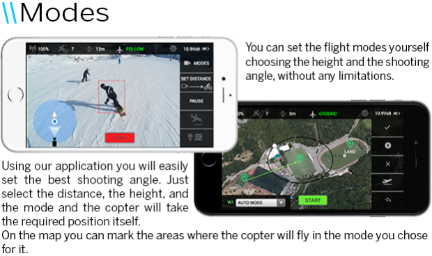
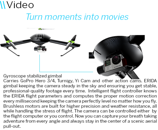
The ERIDA drone constantly tracks where you are and follows you automatically keeping the camera on you and captures your every move.

nuvwth080bqyhhgfhqmw.png

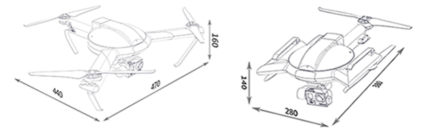
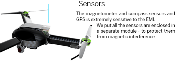
We set out to create the best aerial photography experience you ever imagined. This means the creation of a powerful drone to provide smooth, stable flight dynamics from the moment it takes off. Our drone is also a smart one: it manages the flight in a way that you can retake creative control and focus on getting great videos. People really want great shots and they wish to take them without professional tools. ERIDA enables them to get fabulous videos easily without the need to spend years getting trained as a professional drone pilot.

The ERIDA drone has a wide range of features, from manual flight and camera telemetric controls to fully automatic takeoff, flight and landing. Enjoy filming with ERIDA!

ERIDA Gen.A video

raxomavr7rx9z7fcf22j.png

z0zthwfedhv1w2apa10i.png

s9cdp5vddnwkufdnfjob.png

hlpurmlmobmq9cg07srr.png

sqew2y5bvtykzudoxg5z.png

jfencpyzodser03smv8o.png

The control of the apparatus has never been so simple!

mbglaf7cjhs555ap2lco.png

pqvvpfkuwxokky28egth.png

qnax29if1if5ezjeyd9u.png

dug2tqvgh4kcfvsbvejn.png

ib6o4rjsrg1m1n8iqytl.png

elrtznmaodd4uu2ls7ai.png

aossix3jp7owa8tiqtrb.png


ajgdrwgkiasrwk5k8rp1.png

z4fwnkny8oztotefbdjw.png

z4ceqopf7daals0fuw0z.png

ia2yi1xmjoha8itddhna.png

yvcbr2mlgdmgly8ylvkk.png

xoyh2bl1okrx6mo58gif.png

mqcuvq59vmu0shjjkwu2.png

z4wgxu9x6ukurhtxf7lj.png


yetqfmdgaf8amvx6rp6a.png

n3xmj4mdw8rmcrspvqno.png

disxnrwjqteemjorxrhj.png

bhcygwhcpjwnjnp6bsiw.png

Read more…

3689664881?profile=original

Usage of small dimensions RPAS ( drones ) has a real and practical benefit on forest, environment and agriculture management. Drones can obtain Digital Surface Models and pseudo-NDVI orthomosaics that can be manipulated by Geographic Information Systems (hereinafter GIS) allowing professional and rigorous studies along with technically supported decisions.

We provide here an example of woody crop inventory done with our drones and GIS (QGIS) Software. It can be noted how powerful this information can be to properly manage and take decisions on precision agriculture and forest plantations.

In the following example droning used one of our drones (specifically the DE820) and a NDVI camera to survey the whole field. We did it in one flight at height of 100m above ground. Flight took 10 minutes.

The field was mainly populated by olive trees in the south of Spain.

Once on the ground, we were able to generate the Orthomosaic and both DTM (Digital Terrain Model) and DSM (Digital Surface Model). By using these three sources of information and the raster and vector calculator on the GIS, we could detect and classify every olive tree as an independent entity.

3689664938?profile=original

Having every olive tree entity located in the GIS database, a lot of valuable information can be extracted:

  • GPS Location
  • Height
  • Estimated volume
  • Perimeter
  • NDVI index
  • Surface area
  • etc

Woody crop was identified from surface and other vegetation by means of geographical calculations taking into account a series of parameters like shape, height, area and elevation gradient. At the same time NDVIb color disambiguation was applied to better refine the tree selection.

In this example we were able to differentiate every olive tree from the rest of the terrain and other vegetation present in the study zone.


GIS and drone technology is a game changer in Precision Agriculture and Environment management. This information provides an efficient, massive and rigorous way to manage field crops, forests, and any other geographic inventory.

Data obtained in this way can create massive lists/catalogs of fine geolocated entities allowing categorization, historical comparisons, etc.

3689665002?profile=original

The fact that every olive tree has been categorized, geolocated and found their characteristics is of a great importance now and even more in the future. Almost every new technology related to automatic crop harvest or automatic  fertilizer application will have to be supported by these data.

Moreover, historical data across the years can give precious information about growth patterns and diseases that can me data crossed against production rates per tree etc.

Full post here.

Read more…

3689665018?profile=originalThe Flying Robot international Film Festival, an open competitive film festival focused on drone-based cinema, is seeking short film submissions (<5 minutes). Of particular interest to the DIY Drones community, we're looking for more entries in the Student Film, I Made That and Drones for Good categories.

Student Film - If you're a student and have a drone related class project, document it and consider submitting it. Maybe you are building your own drone? Shoot a short story about it and tell us how you're using it and why it is awesome! Better yet, team up with a friend and make something together. The sky is literally the limit (under 400 feet, of course). Be creative, tell a story and you just might see your film shown on the big screen in a theater full of smiling moviegoers. You might also find yourself going home with a brand new flying robot! 

I Made That - With the advent of desktop manufacturing and 3d printing, we're seeing a rise of beautifully constructed home-built flying robots. Showcase your invention by submitting a film documenting your work. This category is for featuring homemade or DIY creations. It's not necessary that your film be shot from the perspective of your creation, though your flying robot should be central to your film.

Drones for Good - There are numerous stories of drones being used for the betterment of humanity. Search and rescue, anti-poaching efforts, fire fighting assistance, medical aid to war zones are just some examples. Enter your film depicting the positive uses of drones for the greater good of all mankind.


Festival participation is open to anyone around the globe. Submission fees are low (Student Films are free, all others $5 before September 15, $10 until October 15th). Prizes, including 3DR Solos and other flying robots, will be awarded to filmmakers of winning selections. Final deadline for film submissions is October 15, 2015.

The festival screening and awards ceremony takes place on November 19th in San Francisco.

More info on the FRiFF site: http://friff.co

Read more…
Moderator

3689664902?profile=original

Back in 2009 we ran our first pylon style race in a figure eight pattern. It was won by an Easystar using a paparazzi autopilot in a fraction over 49 seconds for a single lap.

This time we asked contestants to complete 5 laps and Dawid Preller flew a blistering time of 221 seconds. That's 44 and a tiny bit seconds a lap including launch and landing. He was flying an A44 Eaglet. No nor had I...

We had a wide range of aircraft Rob_Lefebvre with his Goblin helicopter came second in a time of 281 seconds. A chap called Anderson entered a Solo and Skyfun 348 and 397 seconds respectively.

Robs Goblin

Linus had a go

3689664867?profile=original

I don't think I anticipated any rovers entering, we had four! Well three that tried and the chap Anderson just demonstrated how small his hands are.

3689664819?profile=original

Chris tried to enter a Go kart claiming it capable of speeds in excess of 100 mph! 

But it was not to be.

The Rover course was made smaller as finding 200m square of flat smooth open space proved difficult.

Grant Morpeth seems to have misinterpreted the rules thinking it was a football competition.

The two Rover entries that posted times were Healthyfatboy at 316 seconds and Tom who was plagued with rain and whilst making fast lap times could not get the five in a row in. I suspect he might actually be hiding some advanced tuning in order to  scoop the prizes next time.

So congratulations to Dawid Preller and Healthyfatboy, a Pixhawk courtesy of 3DR will be winging its way to you both shortly.

Congratulations must also go to everybody that entered and sacrificed time and in some cases equipment to help make the APM experience better for everybody. Its these competitions that push things on. 

Perhaps next time we can have some boats as well to make land sea and air.

Unlike those FPV chaps, its real drone racing here ;-)

If you want to know more about T3 take a scroll down the right hand side of the page or click here 

Read more…

3689666017?profile=original

RotorBuilds is a new application that allows multirotor DIYers to price out their build and share the finished product with others.  As you add each part to your build the total price is updated in real time to give you an idea of your total build cost before and after completion.  It offers an extensive social foundation that allows users to discuss builds, talk privately, "like" builds and follow updates from one another.  Ask questions and offer updates about your build to get valuable feedback from the community!

Read more…
Developer

An awesome day at CMAC

3689664667?profile=originalAnyone who has been involved in aeromodelling for a while dreams of having one of those days when everything works right. It doesn't happen often, but when it does it sure is nice!

CanberraUAV had one of those days yesterday. It was a wonderful sunny winters day at our local flying field and we were test flying our latest creations.

First up was the "Vampire Mark 2", a combined plane quadcopter built by Jack Pittar. It consists of a senior telemaster with a 15cc petrol engine, but with the addition of 4 quadcopter motors. It was the maiden flight yesterday, and it was setup with a Pixhawk controlling the quad engines and the rest controlled manually as a normal RC model. We flew with two pilots (Justin Galbraith and Jack Pittar). The takeoff was vertical as a quadcopter, and it then transitioned to fixed wing flight using the extremely simple method of advancing the throttle on the plane while lowering the throttle on the telemaster. Transition was very easy and the plane reached 31m/s in forward flight at full throttle. The landing transition was equally easy. Jack lowered the throttle on the plane while Justin raised the throttle on the quadcopter. No problems!

3689664692?profile=originalGiven this was the first flight of a highly experimental aircraft we were pretty pleased with the result! Jack is thinking of building an even bigger version soon that will be able to complete the 2016 OBC mission with plenty of room for equipment.

Next up was our JS90 helicopter, originally built by Ryan Pope and adapted for autonomous flight.

3689664758?profile=originalThis is the flybar version of the JS90-v2 heli from Hobbyking, with a OS GT15HZ petrol engine fitted, along with a Pixhawk2 and a new "Blue Label" Lidar from pulsedlight. We've been flying (and crashing!) this heli for a while now, but yesterday was finally the day when we got to try high speed autonomous flight.

js90-mission.pngapart from a small gap where we lost telemetry in the north west corner you can see the tracking in the auto mission was great. Once we learned how to tune a flybar heli (which turns out to be extremely simple!) it flies really well. We did have some issues getting it to fly as fast as we want. Above about 17m/s it occasionally pulled back and stopped for a second before continuing. We knew it could do more as it happily flew at over 27m/s in ALT_HOLD mode. With some help from Randy and a small code change to help with tuning we think we've tracked down the cause of that issue and expect to be doing 27m/s AUTO missions next weekend.

Next up was another quad plane, this one quite different from the big telemaster build!

ranger_bebop.jpgWe had been trying to track down a problem with loiter on the Parrot Bebop when running ArduPilot. We suspected there may have been a GPS lag issue, so we wanted to get some flight data that would allow us to compare the performance of a uBlox GPS with the GPS in the Bebop for dynamic flight. We thought a good way to do that would be to strap the Bebop to a plane and take it for a fly. The results were very interesting! For this flight we saw a lag on the Bebop GPS of over 5 seconds, which must be some sort of buffering issue. We'll chat to Julien from Parrot to see if we can track down the issue.

bebop_velocity.pngNext we thought it would be fun to see if something else could lift the tiny Bebop. Peter had his Solo there, so we strapped the Bebop to it and went for a fast fly in drift mode. Great fun!

Overall it was a fantastic day! Next week we're really looking forward to trying the Trex700 petrol conversion that Greg has built which you can see in the background in this photo of our build day on Saturday. The build looks really good and we expect it to perform even better than the JS90, as Greg has managed to fit a Pixhawk while still being able to install the canopy. That should reduce drag quite a lot.

IMG_20150829_152000.jpgThe switch of focus for CanberraUAV to VTOL aircraft has been a lot of work, but the results are really paying off and we're having a lot of fun in the process. We hope that we'll have a lot more weekends like this one in the future.

Read more…
3D Robotics

Using ROS Gazebo simulator with ArduCopter

The future of robotics development, including drones, is powerful simulation, which makes it possible to achieve faster development and better performance by reducing the "trial and error" process of testing everything with physical machines. The Dronecode projects have long used a number of powerful drone-specific simulators, including both "hardware-in-the-loop" (HITL) and "software-in-the-loop" (SITL) programs. 

But as drone simulation goes beyond simply simulating the drone itself and extends to simulating an entire robotic system, including swarming, pathfinding, environmental awareness and autonomous mapping and navigation without GPS, you need even more powerful tools. 

The gold standard for advanced robotics simulation is the ROS/Gazebo package, which is now supported by ArduPilot as part of the Dronecode project (ROS is the Robot Operating System, created by the Open Source Robotics Foundation, which is part of Dronecode).

The APM Dev wiki now has a great page on how to use it. Here's a sample, but click through for the whole thing.

ROS and Gazebo are a well-known and respected robotics framework and simulator:

  • The ROS framework contains many “packets” of software for performing robotics tasks. It allows you to model the environment (including indoor environments with walls, doors etc) and run your own control algorithms for autonomous flight.
  • Gazebo supports several different Copter models (at time of writing there are 6 URDF models in the rotors_simulator package). These can be extended to include support for additional sensors and other behaviours.
Tip:
The ROS/Gazebo is particularly useful for defining autonomous indoor flights.

This article shows how you can replace the default SITL Copter simulation with one supplied by Gazebo and control the autopilot using the ROS framework (instead of Mavproxy or some other Ground Control System).

An architectural overview of how ROS/Gazebo integrate with SITL is shown below:

Architecture Diagram: Using SITL with ROS and Gazebo

Read more…
3D Robotics

3689664379?profile=originalI'd like to take a moment and call out Hamish Willee and the rest of the documentation team, who every day make scores of improvements to the wikis and other documentation for the APM and other Dronecode project wikis. To give just one example, you may have noticed the new sidebar/menu system, which is clean, clear and works much better on mobile.

On the developer documentation, we're moving to a Sphinx theme, which is easier to maintain and integrates well with the code development process. You can see one such example with the MAVProxy page.

3689664604?profile=original


If you'd like to be part of the documentation team, you can participate via the maillist, or just post bug or addition requests via the Issue Tracker. They love new contributors! 

Read more…