Hi guyz, wanted to share the latest on the Atas Defiance 265 development.
For the past 6 months we listened to the flyers feedback and worked hard to improve the airframe in every aspect and we completely revamped the kit!
Atas Defiance 265 Kit Revamp
Now stronger and lighter than ever before!! Aluminium 6061 T6 alloy bridge holders and aluminium 7075 T6 alloy screws as a kit stock! Additionally reinforced motor arms and chassis plates!
- An Swift Binary Protocol driver for ArduPilot, available in the forthcoming ArduCopter 3.3 (currently available in Beta, soon to be released: ).
- Version 23 of the Piksi Console, with support for communicating with ground station software.
- Mission Planner and MAVProxy support for ground station-based GPS corrections.
We are releasing this integration as a major milestone towards bringing centimeter-accurate flight to ArduPilot! But we need everyone's help! There is still significant work up ahead to better use Piksi on ArduPilot! Specifically, we're working to improve ArduPilot's control and estimation systems as to use Piksi more effectively. We're also building an analysis pipeline to help the community analyze the accuracy of their flight paths and debug potential problems with their setup.
To that end,we're issuing a Call for Logs!If you use Piksi on ArduPilot, please send us your DataFlash logs! You can do so by attaching it in a reply to this forum. These logs contains valuable Piksi behavior data, which will help us debug and improve ArduPilot and Piksi.
This announcement represents the culmination of a lot of effort from Swift, myself, and the open source community. I'd like to take this opportunity to thank Andrew Tridgell, Randy Mackay, Michael Oborne and the entire community for their help and encouragement with this ongoing project.
We look forward to everyone's thoughts and feedback about the documentation and current experience with the integration!
University of Glasgow MAST Lab entry to the iMechE Unmanned Aerial Systems Grand Challenge 2014/2015.
The Unmanned Aircraft Systems Challenge (UAS Challenge) bridges the gap between academia and industry in developing applied UAS-related activities.
We designed an H quadrotor that was capable to carry 1 kilogram of flour, do waypoint navigation and drop the payload in a designated area.
This particular vehicle was done using 3D printed parts, and carbon fibre rods, the video explains more about it.
We used Pixhawk as flight controller and a Raspberry Pi 2 as companion computer. Several scripts in python were done to send commands via serial port to the pixhawk, Drone API was used on the RPI 2.
The vehicle flew perfectly in manual and in autonomous mode, several tests were performed. The rpi2 / pixhawk combo is a great way to do UAS applications like this one, and this is a living proof of it.
We had 3 ways of communicating with the vehicle:
- Standard RC
- 3DR radios (900mhz)
- 2.4ghz Wifi high gain antennas using SSH to the RPI 2 and then mavproxy.py to the Pixhawk
Important to notice that we also had an RTSP video server using the RPI camera with 0.5 seconds delay, HD and 30 fps... It worked great.
Our payload mechanism was extremely simple yet very practical and useful, 3D printed as well and fully tested, the video will show that ;)
Tools like the SITL simulator was really helpful to test our scripts before doing them on the actual vehicle, special thanks to the developers that are making this tools easily accesible to us, in Tridge we trust!!!
You might be thinking about how well we did... The vehicle worked great, we passed scrutiny very easily and it was airworthy after just adding some padding for the lipos. The problem was later, a manual test was needed before doing the automatic mission, and it must be flown by a certified pilot...
Currently in the MAST Lab we don't have a certified pilot, so iMechE provided the certified pilot for our vehicle, and as many of you know, every vehicle is different... and being a prototype, even more. The problem is that he did not had chance to practice before doing the actual flight... the vehicle took off, and like at 40 centimeters it pitched super aggressively and the tip of the vehicle touched the ground and it flip, that was it.
That particular part was not in our spare list and our 3D printer was 500 miles away in Glasgow (ergo the last song in the video, duhhhh). Oh, by the way, we have a Makerbot Replicator 2.
Anyhow, we had lots of fun, we learned a lot and most of all it was super fun.
In the picture above you can the one of the motor mounts (blue one) which is the one that did not endure the flip.
Sorry for the long post and let me know what do you think of our vehicle. Any questions, please do ask.
Good article from The Verge about how they GE tests jet engines to ensure that they can withstand bird and hail strikes. The obvious next thing to test is small drones.
Peebles is home to GE Aviation’s Peebles Test Center. Sitting outside "Disneyland for geeks" is a crumpled white car with a sign next to it: "Don’t text and drive." It’s a real car that really crashed when its driver was texting, says Brian De Bruin, the plant leader at Peebles ("If this is Disneyland for geeks, I guess that makes me Mickey Mouse," he says later). Texting and driving is a common problem in rural Adams County, Ohio, the home of the 7,000-acre reserve that tests 1,600 engines a year.
The state-of-the-art facility is located in the middle of nowhere to avoid noise pollution. Hawks lazily float on air currents above us, apparently unperturbed by the occasional sound of engines. Peebles was initially opened in 1954, and was intended to test rockets, though that never actually happened. It acquired its modern function in 1965, when GE ran its first test of the TF39 engine there that would eventually power the Air Force’s Lockheed C-5 Galaxy transport aircraft.
Security is tight, though the guards are friendly — I arrive a little early and am directed to wait for Jamie Jewell, the spokeswoman for CFM, GE’s joint venture with French company Snecma (which startles me every time someone says it aloud — I cannot help but hear the mondegreen "smegma"). Jewell arrives with De Bruin, and we all pile into a minivan. I am very much hoping that I will be able to witness engine tests, but first, Jewell and Chris Nye, marketing manager for Leap, walk me through a video of the brand-new Leap engines — turbofans that will find their way into next-generation midsize airliners from Airbus, Boeing, and China’s COMAC. When manufacturing is going full-tilt, one engine will be built every 5 hours.
An engine to undergo the blade-out test (CFM)
The Leap testing, conducted primarily at Peebles, is meant to be complete by the end of this year. There are, of course, the FAA standards — and meeting them means that GE engines are cleared for Europe and China as well. There’s the over-torque test and teardown inspection, meant to give regulators an idea of the wear and tear the engines may face during their lifetimes; during these tests, the engines experience extreme conditions, meant to determine their durability. There’s the vibration test and the corrosion test; the thermal fatigue test and damage tolerance test; the crosswinds test and acoustic tests. Then there are the fun tests: birds, volcanic ash, dust ingestion, and hail.
But Leap is still undergoing certification testing, the bulk of which is expected to be done by the end of this year. They’ve already finished the bird test and another test, the "blade-out," which I think I like even better than the bird test. Here’s what a blade-out is: a thumb-sized amount of the explosive C-4 is attached to a blade’s base. Once the engine is running at full power, the C-4 explodes, knocking out the blade. The test is to show the engine can contain the lost blade — no one wants it to go careening into the passengers onboard the plane — and that the engine won’t catch fire.
ONCE THE ENGINE IS RUNNING AT FULL POWER, THE C-4 EXPLODES, KNOCKING OUT THE BLADE
It’s De Bruin’s least favorite test because it destroys the engine. "That makes me sad," he says.
The engines have to be durable enough to stand this kind of rough treatment, but they also must be light. Engines are, of course, hung under the wing — where they create drag, so engines must generate the needed thrust to get the airplane off the ground while minimizing weight penalties — the thrust-to-weight ratio is seven to one on the Leap engines. And the heavier the engine and the plane, the more fuel it burns. Fuel is expensive, accounting for more than a quarter of airlines’ operating costs — the single largest cost most airlines have. In the interest of saving weight, GE uses 11 miles of carbon fiber woven into each of its Leap blades, like a T-shirt woven on a loom, with a titanium leading edge. That’s for the birds — it’s essentially a knifeblade. The engine also boasts ceramic components to improve fuel performance and 3D-printed fuel nozzles.
In case they passed you by without notice – and it’s quite likely they did – the May announcements that retail giant Walmart and Silicon Valley technology-disrupter Google are getting involved in the Automatic Dependent Surveillance-Broadcast (ADS-B) system manufacturing industry are being viewed as game changing by folks in the large-scale commercial UAV market, and with good reason.
In a nutshell, ADS-B is a real-time aviation data broadcast ecosystem that allows aircraft to send and receive critical location information. It is “automatic” in that it requires no pilot interaction, and it is “dependent” in that it requires transmission and analysis of aircraft data to work. The system is one of four components in FAA’s proposed Next Generation Air Transportation System (NextGen).
ADS-B systems feature two mechanisms, the foremost of which (for drone enthusiast purposes) is the ADS-B “out”, which transmits information about altitude, airspeed and location derived through GPS from an equipped aircraft (or potentially a UAV) to ground stations and to other equipped aircraft in the vicinity. Air traffic controllers rely on this information to “see” operating aircraft in real time.
The other component of the system is the ADS-B “in”, which is not included in the 2020 FAA mandate (requiring all manned aircraft be equipped with ADS-B out sensors by 2020). ADS-B in allows participating aircraft to receive air traffic and weather information from ADS-B ground stations and nearby ADS-B out-equipped aircraft. This information is displayed on a cockpit monitor to improve situational awareness.
So, what does all this have to do with drones? Well for starters, for companies like Google and Walmart that have visions of launching large autonomous fleets of on-demand delivery drones (similar to Amazon.com’s well-publicized plans), making the ADS-B technology more accessible (not only to their own interests, but also to the aviation industry as a whole) and robust is a true no-brainer, especially if it provides the added bonus of easing the minds of the regulators that will have final say on approval of these coming-soon drone delivery services. Fighting the good Public Relations fight is always important, especially so in dealings with government bureaucracy.
One of the highest hurdles currently to widespread adoption of ADP-B tech in the U.S. is that the price tag makes it a tough sell where regulatory agencies aren’t mandating its adoption. Why the Google and Walmart announcement carried so much weight in drone circles is that if Google can figure out a way to get the average cost of the hardware for a ADS-B system (current averages have this cost at $2,000 plus heavy installation fees, and the ADS-B out component alone can cost between $5,000-6,000 to equip an aircraft) down to around $500 or even lower, the system will be installed in many more aircraft.
So it’s really almost a “Win-Win-Win” for a well-funded and highly capable player like Google to get this done. Google wins by helping the industry meet its 2020 mandate for ADP-B adoption, showing regulators they are serious about airspace safety stewardship. Then its drone delivery fleet gets the regulatory green light and the rest of the aviation industry is happy because the company made meaningful investment in the industry, making the airspace safer for everybody.
Adam from http://www.aeroworksproductions.com talks about the new 3DR Solo "Smart Drone". The good, bad, ugly and first flight tips. More reviews to come when the Solo gimbal is finally released as well as "How To" videos.
I am happy to introduce VR Neuron II's latest virtualrobotix platform. The goal is to have the maximum possible integration from a Flight Control as VR Brain based on micro controller STM32, extremely reliable with many hours of flights behind with a companion computer based on RPI2 that through a dedicated IMU will work Parallel to the VR Brain and also to provide advanced features such as internet connectivity, management or payload or functionality of digital and brushless gimbal.
One of the best feature of Neuron is that a lot of your "old" sensor and device could be re usable in your new proget : GPS , Telemetry Module and IMU sensor is compatible with VR Neuron II Board. We planned to develop a modular architecture that allows the addition and improvement of the capabilities of the system through the logic of the update online and why not of online , app store. The first platform for developers and partners will be made available from September will be immediately available software to connect to the internet and to manage payload in DIY and RTF configuration. For some ideas that gave birth to the project I wanted to thank the guys from the project NavIO and also Victor the CEO of Erle Robotics as well the DIYDrones Teams that did a great work on Linux port of APM Platform :)
The easier FAA Section 333 process and an overall sense that the US commercial drone regulatory process is heading in the right direction is leading to a boom in applications and approvals. Excerpt from a good Verge article:
The US is finally catching up to Europe and Canada.
Over the last two years, the lack of a legal framework for commercial drone flight in the US has slowed the growth of the industry domestically. Despite creating some of the world's most advanced drone technology, the US was lagging behind other advanced nations in putting that innovation to work. "Getting an FAA exemption was pretty complicated, and hence you mostly had just larger companies, military contractors, and big energy firms spending the effort to obtain them," says Bilal Zuberi, a venture capitalist with investments in the drone industry. "At one point having an exemption was thought of as a real competitive advantage. That's no longer the case. It’s now just a basic, painful, bureaucratic process of standing in line to get your permission."
In the six weeks since we started working on this project, the number of drone exemptions processed by the FAA has nearly doubled. "Over the last 12 months, one of the things I have noticed is major corporations have decided the existential risk of drones is gone," says Zuberi. "Now most big companies have tasked somebody to figure out their "drone" strategy. Previously there was a lot more action happening overseas. Thankfully, that is starting to change."
From the New America foundation, an interesting conference in Washington DC on Wed, July 22. It's backed by the Omidyar Network, which is run by Pierre Omidyar, the founder of eBay.
Clear and secure rights to property—land, natural resources, and other goods and assets—are crucial to human prosperity. Most of the world’s population lacks such rights. That lack is in part a consequence of political and social breakdowns, and in part driven by informational deficits. Unmanned Aerial Vehicles (UAVs), also known as drones, by virtue of their aerial perspective, are able to gather large amounts of information cheaply and efficiently, as can unpowered aerial platforms like kites and balloons.
That information, in the form of images, maps, and other environmental data, can be used by communities to improve the quality and character of their property rights. These same tools are also useful in other, related aspects of global development. Drone surveillance can help conservationists to protect endangered wildlife and aid scientists in understanding the changing climate; drone imagery can be used by advocates and analysts to document and deter human rights violations; UAVs can be used by first responders to search for lost people or to evaluate the extent of damage after natural disasters like earthquakes or hurricanes.
Earlier this year, New America launched a website, drones.newamerica.org, which comprises a database of such uses of drones, as well as the first comprehensive compilation of global drone regulations. In conjunction with this July 22nd Symposium, New America is publishing a primer that discusses the capabilities and limitations of drones in advancing property rights, human rights and development more broadly. The primer contains both nuts-and-bolts advice to drone operators and policy guidance. Though drones have substantial potential—in particular they are capable of making new maps cheaply, in a decentralized fashion—they are also a technology with pitfalls.
Please join Anne-Marie Slaughter, New America’s president and CEO, for a half-day discussion of these important issues. Breakfast and lunch will be served.
This program is made possible by the support of Omidyar Network and Humanity United.
Follow the discussion online using #NewAmericaDrones and following @NatSecNAF.
Agenda:
8:00 am Registration and Breakfast
9:00 am Welcome Remarks Anne-Marie Slaughter, President and CEO, New America Peter Rabley, Director, Investments, Property Rights, Omidyar Network
9:30 am Mapping for Property Rights Irendra Radjawali, University of Bonn, on Indonesia Aldo Watanave, Peruvian Ministry of Culture, on Peru Gregor Maclennan, Digital Democracy, on Guyana Moderator: Faine Greenwood, New America
10:15 am Political Geography of Aerial Imaging: Ethics, Surveillance and Privacy Shannon Dosemagen, Public Lab Lisa Ellman, Hogan Lovells John Verdi, National Telecommunications and Information Administration Moderator: Konstantin Kakaes, New America
10:45 am Practicalities of Mapping Walter Volkmann, Micro Aerial Projects Mathew Lippincott, Public Lab Georgi Tushev, Tushev Aerials Moderator: Rob Thompson, UAV Consultant
11:15 am Drones and Conservation Serge Wich, Liverpool John Moores University
11:30 am The Regulation of UAVs: Air Safety, Privacy and New Technologies Leslie Cary, ICAO Ella Atkins, University of Michigan Troy Rule, Arizona State University Moderator: Margot Kaminski, Ohio State University
12:15 pm Drones and Peacekeeping: the DRC and Beyond Konstantin Kakaes, New America Walter Dorn, Canadian Forces College
12:45 pm Lunch
1:15 pm Drones and Disaster Response Patrick Meier, Humanitarian UAV Network Abi Weaver, American Red Cross C.J. Guiness, Unity Development Group Moderator: Craig Whitlock, Washington Post
2:00 pm The Future of Commercial Drones Darryl Jenkins, American Aviation Institute Bradford Foley, Foley Strategies
2:30 pm Concluding Remarks Peter Bergen, Vice-President, New America
Interesting camera with Global Shutter. Can imagine so many VR applications when mounted on a drone! This has 60FPS and 4K video output Hope the Wifi thingy can be turned on and off to avoid radio interference. Update: Wifi can be turned on and off!! (Jeffrey has added a comment at Kickstarter project page).
This is from Jeffrey Martin at sphericam.com and 360cities.com
I just released a new research report. It details the state of the commercial drone industry in the U.S. as of the end of June 2015. It looks at recent innovations, business applications, key ecosystem companies, and market forecasts. It analyzes the business impact and market opportunities that proposed Federal Aviation Authority (FAA) rules have on unmanned aircraft systems (UAS) manufacturers, distributors, service providers, and investors. The report is a great primer for those who want to take advantage of the coming boom in this potentially lucrative industry. It provides fresh information for industry veterans, entrepreneurs and investors, career changers/advancers, and corporate personnel in all industries. The full text of the report contains the most salient industry statistics illustrated by 12 figures and four tables.
Impressively tiny given the GPS, autopilot and promised LTE connection option. Virtual FPV racing and indoor/outdoor use. On Kickstarter now:
tobyrich.vegas next to an iPhone 5 and a Samsung tablet
VIDEO GAMING meets ADVANCED DRONE TECHNOLOGY!
They are smartphone controlled drones with many sensors and app that is designed like a computer game. A large amount of sensors from the drone, phone and the internet is giving a real-time picture of the situation. Our fleet of drones is equipped with GPS, 4G/LTE, a 9-axes sensor, Bluetooth Smart technology, an HD camera and much more! Based on the exact position and movement of the drone and phone, you will be able to explore amazing games such as Dogfights, Air Races and Stunts.
We can predict the impact of a rocket, the perfection of a looping and estimate the distance between two drones.
You can also use our gaming drones like a normal remote controlled plane and fly it through the free flight mode by tilting the phone or by using our joysticks.
For someone could be a way to do magic tricks but for the majority of those who use a Bebop is an annoying effect of which probably have not even noticed thinking is normal behavior or the cause of an error of piloting.
We are talking about a lack of flight behavior of the Bebop, seemingly inexplicable, which was recently reported by some users and on which we have investigated to discover the cause and find a solution.
Basically it happens that if the Bebop is flying in a gray area and is struck by the sun, suddenly drastically lowers the flight altitude as if the sun goes in the shade increases considerably the flight altitude.What happens at a short distance from the ground where the ultrasonic sensor that should keep the height, but the data fusion with the barometer so influence the final calculation that causes this effect.
The reports concern, perhaps only a coincidence, bebop yellow and so placing a specimen we tested it.And it went exactly as reported, making shadow in the area faired polystyrene, which is located under the GPS, bebop rooms share alone then dropped when the sun strikes.
THE CAUSE OF BEBOP CLIMBING DOWN AND HE HIT BY SHADOW AND THE SUN
After detecting the problem, which affects the behavior of flight whenever there is' a change of light intensity from the sun (even just a cloud or fly / tack against the sun) we removed the hull polystyrene and found that under the GPS module is installed, the barometric pressure sensor MS 5607
Despite being under the keel and angled downward, the 'MS5607 suffers from a little-understood problem, perhaps unknown even by engineers at Parrot who have chosen the materials for the fairing of the Bebop.
When hit by infrared / ultraviolet sunlight, this type of sensor (it was also successful on the DJI NAZA M V1 which mounted the 'MS5611 VIDEO ) varies the pressure reading indicating a false and deceiving the autopilot so he thinks to be a height different from that of a few moments before.E 'in this way that the bebop is a change in altitude sudden that, depending on the intensity of the instantaneous variation of the brightness, can be of several meters.
We have demonstrated in our video, just shade even with one hand, in the area of the hull where below is the GPS and the barometric sensor, the bebop gets up suddenly share.Analyzing the hull polystyrene we found that this material passes the light.Ours was yellow but we think that even the red and blue do go the same way the sun's rays.
To resolve must make sure that the sensor is in an environment where where is not hit by the light (from a change of brightness) and then a solution is to screen externally or internally the hull waiting for the Parrot notices the problem and propose an official solution.
IF YOU HAVE A BEBOP DO A TEST AND LET US KNOW Commenting THIS ARTICLE
This is some really exciting news. Curious what FC is onboard. From the team:
The AtlantikSolar Unmanned Aerial Vehicle took off on June 30th at 11:14 o’clock to attempt the “holy grail” of solar-powered flight: The crossing of a full day-night cycle on solar-power alone. More than 28 hours later, on July 1st at 15:35, the aircraft landed safely and with fully re-charged batteries , thus proving AtlantikSolar’s perpetual endurance capability. The long-endurance flight capability shown by AtlantikSolar is of significant interest for large-scale disaster support, industrial inspection or meteorological observation missions, especially in the compact form of a hand-launchable 7kg UAV such as AtlantikSolar.
The flight was performed at the Rafz RC-model club airfield in excellent sun conditions. After take-off at 11:14 at 57% battery state-of-charge, the aircraft was quickly setup to follow an efficient and fully-autonomous loitering path, which allowed a completed battery-charge at 14:08 o’clock. The noon and afternoon were characterized by strong thermal up- and downdrafts, but enough power was generated by the solar panels to keep the batteries full. Their discharge started only when the sun slowly settled at around 19:30. The night flight provided calm conditions, with the autopilot keeping the aircraft stable despite horizontal winds of up to 5m/s, and the safety pilots keeping a good eye on the aircraft using its position indicator lights. Flying at an average airspeed of 8.4m/s (point of minimum sink rate) and an average power consumption of 43W during the night, the aircraft received first sun at around 5:50 o’clock, and maintained a minimum state-of-charge of around 35% until the solar modules re-generated enough power to stay airborne. After 24 hours of continuous flight, the aircraft had recharged its batteries to more than they were a day before, i.e. to 84% state-of-charge, which proved the perpetual endurance capability of the airplane. In addition, the batteries were fully charged at 12:43 o’clock and therefore 1h25 earlier than on the day before. AtlantikSolar landed safely at 15:35, thereby setting a new Swiss endurance record for unmanned solar-powered flight, and improving the previous internal record (ASL’s Sky Sailor) by a bit more than an hour.
The project’s next goal is to extend the flight duration to more than 80 hours (3 days), thereby beating the old endurance record for solar-powered UAVs below 20kg (48h flight by the 13kg SoLong UAV in 2005) by more than a day. In addition, upon achievement of 80 hours flight endurance, the 7kg AtlantikSolar would be the third-longest flying aircraft in the world, only behind Airbus Space’s 53kg Zephyr and the 2300kg Solar Impulse 2.
I just got back from Paris, where I was meeting with the Parrot team, who are now part of the DroneCode project. Here's the first glimpse of what they are working on: the APM code running on the Bebop drone! The picture was taken at Parrot's HQ in Paris; the team that did the work is in the background.
Right now it's in an early alpha (here), but it was flying very well. That's me (with hat) on the Logitech controller in the background. Any twitchy moves are all pilot error ;-)
I wanted to (quickly) share some experiences with the use of drones in firefighting, as my UAS and goals differ a bit from most departments we've seen that are starting to use drones.
I am a career firefighter that recently relocated to a small rural community in Oregon, surrounded by thousands of acres of agriculture. While we do get structure fires, the majority of our fires are wildland, usually involving wheat fields. In many situations, multi-rotors make a lot of sense (see: Branford fire uses DJI Phantom on quarry fire). I also have a multi-rotor that stays near my turnout gear and I've gotten in the habit of grabbing it if I'm heading to a structure fire. Thus far, I have yet to respond to a call where it would be useful. The main reason I started building my own fixed-wing drones is to increase flight time and allow for active and ongoing monitoring of large, non-structure fires. My main goal for this project is to create a resource that is invaluable for planning a fire attack, and is therefore useful enough to justify taking a firefighter "out of the fight" in order to operate the drone throughout the event.
We are still working on our 333 and COA application, which I have been neglecting way more than I should have during this entire 6 months. Because we don't have the authorization to use these during a fire (And I'm not talking about USFS or DOI managed forest fires), I have been very reluctant to use them during an event. Most of my testing is taking place after the fact and during my off time, and very soon we will begin using them during our weekly training drills.
In the mean time, I've been using a few to map and assess the damage a day or two after the event. I have been speaking to NFIRS and firehouse.com about using drone-created imagery for our fire reports and investigations.
I do have one of the fixed wings set up with video and some low quality "night vision" and 2 5.8ghz receivers on the ground, but the quality is underwhelming. Once I am able to get the gimbal tracking dialed in for ROI monitoring in a loiter, I will look into upgrading the live feed quality and hopefully try to find some funding for a thermal camera.
Thank you for looking. If there is some interest in progress and use, I'll try to keep the blog updated.
Wheat fire mapped 2 days later with a Phantom2
NIR and NDVI mapped 1 day later with a Pixhawk powered fixed wing, processed by agribotix.
There has been a lot of discussion recently on DIYDrones about GPS accuracy, the reliability of autonomous flight modes like Return to Home, and safe flying conditions. These are all valuable discussions to be had, but it is also is helpful to consider how well GPS-based positioning works in the best of conditions.
To generate the plot above, I launched and RTLed Solo 26 times and recorded the landing position with tape. These flights were conducted on a flat rooftop in Berkeley with a totally unobstructed view of the Southern sky. I typically had 8-12 satellites for each one of these flights.
I then took an image from the air using Solo with a flat-lensed GoPro and measured the angle and distance from the takeoff zone in ImageJ.
Over these 26 landings, the maximum deviation was over 6 feet and the mean was around 3 feet. I hope this is helpful for those new pilots in the community who are just beginning to experiment.
If more precise landing are desired, there are some excellent dev options out there like IR-Lock, which does not rely on GPS, and Piksie, which does.
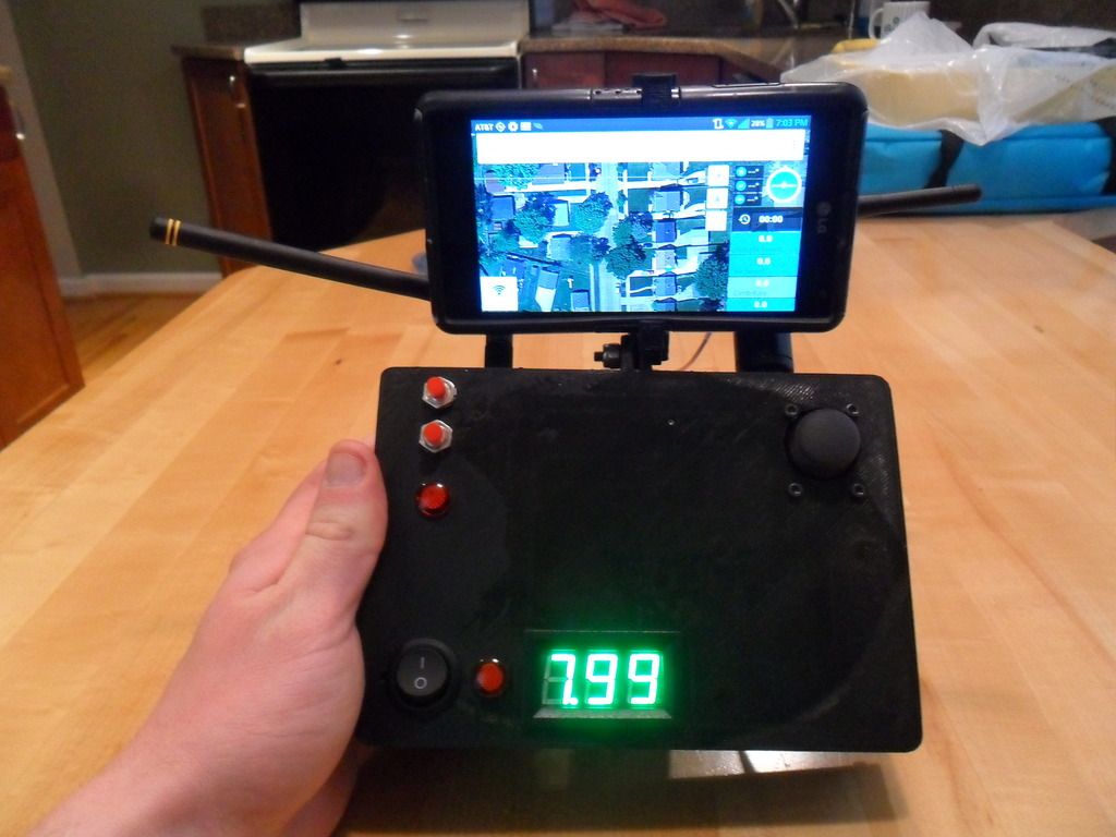
Making your own transmitter is pretty easy. I can now program everything exactly as i need. For example, the shutter control for my NEX5 requires a momentary button that is not held down... I can now format the command from the transmitter to switch for the correct amount of time.
Aeromao Inc. A leading edge UAV manufacturer from Canada has recently made several updates to its Aeromappers family of drones as well as additions to its payload offerings.
The Aeromapper family of UAVs consist of three different drones aimed for mapping and survey applications with currently no match in the market. All three UAV model support:
- wide selection of sensors
- real time video downlink optionally available from the mapping cameras, including FPV for Aeromapper EV2 and Aeromapper Talon
- parachute or belly landing capabilities
- Camera always in panoramic orientation (offers the most area coverage per photo)
- long range data & control links
- fully autonomous flight
- each and every UAV is flight tested before delivery
- delivered complete with accessories
- carrying case and 24 megapixel camera with TOP QUALITY OPTICS (not just high resolution)
- easy handlaunch
- modular construction
- made in Canada
- interchangeable parts
- automatic lens protective door
- several image processing software packages
- Fully detailed manuals
- No training or experience necessary. Trainings available as optional
- no other drone match these offers AND price.
The specifications of each drone model can be found here:
The Aeromappers truly offer the most competitive price and most comprehensive package for both first time users and experienced drone operators. Most drones out there offer only a fraction of the features offered by the Aeromappers, at usually twice the price or more!
All Aeromappers offer a carefully conceived parachute landing system that allows users with no RC skills to land pretty much anywhere safely, including tight areas and unprepared terrain. It also offers the ultimate fail-safe method. Authorities regulating the use of UAVs for commercial applications like FAA or Transport Canada for example, carefully evaluate the failsafe measures on each UAV on question prior to issuing any permit and see with good eyes systems equipped with ballistic parachutes that can be deployed on demand, just like the Aeromappers offer.
Other fixed wing UAVs that don’t have a properly engineered parachute landing system usually “crash-land” autonomously (whether it belly lands, reverse thrust or deep stall), resulting in very short life spans, constant repairs needed and often busted cameras.
Other UAVs also offer very few camera options, short range communications or require complicated launching methods while in contrast all Aeromappers are hand-launchable, support many different cameras & sensors and have long range communications (data link & control, +20Kms).
All Aeromappers are based on full three axis platforms (yaw, pitch and roll) which offer the best possible flying characteristics.
It is noticeable that Aeromao offers only medium to large sized UAVs (2m to 3m wingspan aircraft) with conventional configuration (with separate rudder and elevator control), not flying wings. And there’s a reason for that: small flying wings are not the best mapping platform. Since they don’t have separate rudder control the only way to control crosswind situations is with constant changes in the roll axis, resulting in off-nadir imagery, need for stabilized camera mounts and “nervous like” flying characteristics. Also, small flying wings are by nature very critical dynamically, unstable and difficult to launch. The Aeromappers in contrast, can compensate a crosswind with inputs on the rudder while maintaining the wings level, therefore eliminating the need for camera gimbals.
All three of the Aeromapper packages include a 24 megapixel camera with top quality optics as its standard camera, but more sensors can be added. For the full list visit http://aeromao.com/uav_payloads
Aeromapper Talon:
The standard package of Aeromapper Talon includes long range communications, but alternatively it is also offered in a frequency friendly version for European customers or were 900 Mhz is not allowed. This particular version is priced at only $6,900 USD, includes UAV flight tested, 24 Mp camera with survey grade lens, parachute system, carrying case, 1.5 – 2 km range, User Manual, 80 mins flight time, batteries, charger, accessories and of course fully autonomous flight capabilities. This UAV puts in the hands of the many true professional capabilities. Currently 10 single sensor packages and four RGB+NDVI dual sensor combinations are available for this UAV variant, with more currently to be added.
Aeromapper EV2:
The Aeromapper EV2 has a truly impressive performace and great area coverage rate per flight, since it’s cruise speed is a little higher than the other two Aeromapper models. It is also a great choice when the wind is very strong. It’s an all round solution that is simple, rugged, very quick to setup, dependable and very competitively priced.
The Aeromapper 300:
The Aeromapper 300 is truly a unique machine. It is our most capable UAV. It has 1.5 – 2.0 hrs of endurance, truly multisensor capabilities and standard +20 Km long range communications. Currently supports 13 single sensors or 5 dual sensor combinations at the moment of writing this post, including the Sony A7r 36Mp camera. More single & dual sensors will be added very soon.
The Aeromapper 300 also enjoys now an ungraded power setup that totally eliminates the need for catapult launches! It is now much easier to perform hand-launches in any conditions, like full payload and no wind, carrying for example the Sony A7r 36 megapixel camera.
Aeromao is also very proud to offer currently two image processing software with its Aeromappers: the Agisoft Photoscan Pro and the Pix4DMapper Aeromao Edition.
The Pix4DMapper Aeromao Edition is a dedicated version of the famous software specifically suited for the Aeromappers. It is offered as a bundle with each Aeromapper model at a price that offers absolutely the best deal out there.
The Aeromapers are fantastic tough working machines that will keep evolving offering even increased capabilities and accessories to its users well into the future.
The Aeromappers are currently being operated in more than 35 countries.

 tobyrich.vegas next to an iPhone 5 and a Samsung tablet