All Posts (11086)

Sort by

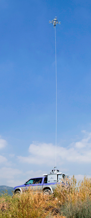
Sky Sapience Delivers pre-Production Hovermast to IDF

hovermast100_up.jpg

Hovermast answers the requirement for rapid and timely intelligence gathering at the tactical echelon. The system employs a sophisticated, electrically powered platform using a main lift fan and four stabilizing rotors, maintaining the platform in flight, hovering and maintaining stable line of sight with a target of interest even when subjected to strong winds or wind gusts. The system carries sophisticated multi-sensor payloads operating day and night under all weather conditions. Hovermast 100 carries 13 pounds (6 kg) of payloads.

Sky Sapience Hovermast

Read more…

Loveland Pass FPV Proximity Flying

Last Saturday I was finally able to do a flight I've been wanting to do pretty much since starting FPV. I took my Deep Reaper flying wing up to the top of Loveland Pass, Colorado for some awesome proximity action along the ridge line above the Arapahoe Basin ski area. Even though the lighting wasn't the best because of the dark clouds and my Deep Reaper isn't all that stable in high speed dives, the result turned out fantastic.

Read more…

Super simple script for remote camera triggering

(Re-post from: http://conservationdrones.org/trigger-camera-remotely/)

I know there are already lots written about remote triggering of cameras, including one on 3DR's webpage. I just want to share an extremely simple ‘.bas’ script that works well with a CHDK-USB cable gentWIRE-USB or E-flite LED controller). BTW, see Flightriot.com’s excellent video on how to build such a cable.


@ConservationDrones Remote Script 9/2013
:wait
if is_key “remote” then goto “loop” else goto “wait”
:loop
shoot
sleep 1000
if is_key “remote” then goto “loop” else shut_down


To start taking pictures, flick a switch on your radio transmitter (or output a PWM>1900 signal from APM). The camera will continue to take pictures repeatedly as long as the switch is in the ‘ON’ position (or PWM>1900). To stop taking pictures and shut the camera down, simply flick the transmitter switch back to the ‘OFF’ position (or output a PWM<1100 signal from APM).

Read more…
3D Robotics

3689545638?profile=originalMore great press for APM-based Conservation Drones! From Reuters:

LONDON (Thomson Reuters Foundation) - When NASA wanted to take a closer look last month at melting sea ice patterns in the fast-warming Arctic, it turned to an unusual bit of equipment: an eco-drone.

The plane-like device, about the size and weight of a pony and loaded with sensors, was launched at the remote Oliktok Point Long Range Radar Station in northern Alaska, gliding onto the water about 65 km (40 miles) later after its engine lost power.

A week later, near Glover’s Reef off the southern coast of Belize, a much smaller 2.5 kg (5.5 pound) Styrofoam vehicle, resembling an oversized model plane and carrying a small video camera, took off over the open ocean, soaring through winds of 30-40 km per hour (19 to 25 mile per hour).

Unmanned Aerial Vehicles (UAVs), better known as drones, are best known for their use in military settings. But scientists and researchers are quickly discovering their value in environmental and conservation projects, from tracking the effects of climate change to monitoring conservation projects.

The Arctic and Belize drone launches represent just a fraction of new projects exploring how drones may contribute to understanding and protecting the environment – and even saving lives.

Drones, for instance, might be used to monitor glacial lake outbursts in the Himalaya, such as the one that contributed to nearly 6,000 deaths in India’s Uttarakhand state in June, and to help provide early warning for surrounding villages. And as more grassroots organizations and researchers get their hands on UAV technology, a much greater range of information on climate threats, and how adaptation and mitigation measures are working, might become available.

The Belize drone was launched as part of Conservation Drones, a project (likely to work towards non-profit status in the near future) which aims to make drone technology more accessible to conservation workers and researchers. The test flight was aimed at seeing how well a drone could handle high, sustained winds, but the drone soon will help the local fisheries department monitor illegal fishing.

There are many other “eco-drones,” now in the field, with a great variety of designs and uses. Endlessly customizable and increasingly capable, the drones are proving a boon for climate researchers and conservationists alike, offering resource- and time-saving “eye-in-the-sky” technology. Challenges remain in using the drones, but the field is rife with innovation.

....

CITIZEN DRONES

Projects like these require capable machines, packed with special instruments and featuring the sleek design that many have come to associate with drone technology. But just as exciting are initiatives to put simpler, homemade drones in the hands of local organizations and individual researchers.

Conservation Drones, which launched the UAV in Belize, is the leading initiative working to bring drone technology to environmentalists. It’s a two-man enterprise, run by conservation ecologist Lian Pin Koh and primate biologist Serge Wich. They saw the potential applications of drones for conservationists in the developing world, but found that commercially available UAVs were far too expensive.

The pair didn’t expect big demand for drones when the project started, Wich said. But when word got out on the low-cost model they created, groups around the world – from the World Wildlife Fund to national parks departments – took interest. Conservation Drones now has several different drone models in locations as diverse as the beaches of Gabon and the tundra of Greenland.

Koh and Wich post footage from all their projects: surveys of land burned for oil palm plantations in Indonesia, training sessions at the Democratic Republic of Congo’s Odzala National Park, a bird’s-eye view of Belize’s coral reefs.

The pair donate their time to build the customized drones and provide training, with conservation organisations paying only for materials.

Julio Maaz is community fisheries coordinator for the Wildlife Conservation Society in Belize, which helped connect Conservation Drones with the country’s fisheries department. One big advantage of using solar-powered drones to monitor illegal fishing, he said, is that “once they’re purchased, the cost of operating them should be nearly zero.”

Right now, one vessel on one patrol round uses about $30 of fuel. That’s not to mention the staff, equipment maintenance, engine repair and possibility of running aground on one of the about 800 reef patches in the area.

Seeing the drones for the first time “was like opening a present for Christmas,” Maaz said. “Even crashing them was exciting, because we could understand what might happen if they weren’t landed properly. I must say that two of the three crash-landed and survived. They’re pretty sturdy.”

Another drone user, Jeff Kerby, a PhD student at Penn State University in the United States, studies the impacts of climate change on herbivore ecology. He took a UAV to his research site in Greenland’s tundra to test how it would perform in a colder environment.

Whenever he showed photos of the drone to other scientists in Greenland, including ice researchers and geologists, “I could see the gears churning,” he said. “They’re like, ‘Oh, man, I could really use that to study ice flow in this fjord, or map out this hill. I didn’t know that was possible.’ It’s a really exciting area to talk about with other scientists.”

THE FUTURE OF ECO-DRONES

The pair of researchers behind Conservation Drones say they are still working to improve the safety and reliability of their drones, to make them as user friendly as possible and to give them new capabilities that users have requested, such as the ability to land on water or fly through a forest without bumping into things.

Another priority is establishing clear rules on using UAVs in regulated airspace. “Drone development is going very fast, and it will go even faster once regulatory framework is a bit clearer for usage of these systems,” Wich said.

There’s another issue for drones, as well – their reputation. “The press around UAVs, using this terrible word ‘drones’, is so focused on the bad things they do, like defense applications,” Fladeland said. “As a practitioner in this field, it frustrates me that the good things are not publicized.”

But some of their new uses may help boost the image of eco-drones. Fladeland points to a partnership between NASA and the California Department of Forestry and Fire Protection that has drones helping firefighters navigate wildfires, and potentially saving lives.

“It’s very important technology,” the NASA manager says. “It’s an exciting new tool in the tool kit, and we want to share it with everyone.”
Read more…

Civilian Drones - BBC Radio 4 Broadcast.

3689545614?profile=original

Civilian Drones

Duration:
30 minutes
First broadcast:
Thursday 05 September 2013

For decades, unpersoned planes have been used by the military in places such as Afghanistan and Pakistan to watch the ground and deliver weapons controlled by remote pilots thousands of kilometres away. But now companies and experts are putting their minds to turning military drones into civilian vehicles that can do things cheaper and better than piloted planes. Peter Day investigates unmanned aerial vehicles and how they are already being used by farmers and the police. Also, could a... Show more

http://www.bbc.co.uk/programmes/b039d4cy

Read more…

3689545530?profile=original

The new PX4 Pixhawk module is an evolvement of the existing FMU and IO modules and completely compatible. The main difference is the target audience: While the FMU and IO stack is super small (the size of an average 8 ch RC receiver) but in some ways almost too densely packed, Pixhawk has more space, more serial ports and more PWM outputs.

As the above picture shows, there are two groups of servo connectors, one main group of 8 outputs which are wired through the backup processor, and an auxiliary group of 6 outputs directly wired to the main processor. The port labeled "RC" can take normal PPM sum or Futaba S.Bus inputs, the port labeled "SB" can read RSSI our output S.Bus to servos. A Spektrum satellite compatible port is on top (labeled SPKT/DSM).

The basic operation is the same, and the software is shared. Inside Pixhawk a FMUv2 and an IOv2 do their duties on a single board (and developers will find that the software will refer to FMUv2 and IOv2)

The main differences between old and new are:

  • 14 PWM outputs vs. 12 PWM (old)
  • All PWM outputs on servo connectors (old: 8 on servo, 4 on DF13)
  • 5 serial ports vs. 4 (with some double functionality, so only 3 in some configurations on old version)
  • 256 KB RAM and 2 MB flash vs 192 KB RAM and 1 MB flash (old)
  • Modernized sensor suite (latest generation)
  • High-power buzzer driver (old: VBAT driven, not as loud)
  • High-power multicolor led (old: only external BlinkM support)
  • Support for panel-mounted USB extension (old: not present)
  • Revised, improved power architecture
  • Better protection on all input / output pins against shorts and over voltage
  • Better sensing of power rails (internal and external, e.g. servo voltage)
  • Support for Spektrum Satellite pairing (needed some manual wiring work in v1, but also software-supported)
  • No more solid state relays on v2 (was not really used)
  • Connectors easier to disconnect in case, as the surrounding plastic helps to place the fingers correctly (more on this in a separate post)
  • Case prevents one-off failure operation of servo connectors
  • The new unit is consirably larger, has the same height, but offers in general more handling convenience.
  • External power supply similar to existing 3DR power brick (every unit comes with a free module)

Both generations offer the same backup / override processor that allows failover to manual if the autopilot fails in fixed wing setups. For software developers the differences are nicely abstracted in the PX4 middleware, and can be sensed / configured at runtime.

Pixhawk is available for pre-order here.

Read more…

Labor Day Weekend Quadcopter Build

3689545491?profile=original

My 5 year son executed a fantastic Labor Day build, so I thought I would share... 

Frame: Mead Heavy Weight construction paper in "X"

Autopilot: "authentic" purple APM 

GPS: Yup, that is the white thing.

Props: Orange

This quad also advances the state of the art by including a feather "to see how fast the wind is blowing" - no joke, that is what he said.  I may try that on my quad.

Anyhow, this made me laugh and I thought I would share, for those in the US have a nice labor day weekend - outside the US, have a nice weekend too.

Read more…

Why the drone crashed into the stands

3689545572?profile=original

Owner knows why drone crashed into stands at bull run

Found the story intriguing. Batteries remane fickle things. Their total charge is still only estimated by stopwatches & coulomb counters, but there is no dip stick for a battery. Even a pilot experienced enough to keep 1 eye on the flight time while the other eye is on the 5000 other details still is often surprised when a battery comes up empty ahead of schedule.

Sometimes you forget to charge batteries. Battery chargers sometimes don't finish charging because they overheat or their own supply sags. Sometimes they don't start charging because of a balky button or a poorly designed user interface. Sometimes they report maximum voltage despite no longer holding a full charge.

A return to launch feature when the battery is low also remanes fickle. GPS comes & goes anywhere besides a wide open field. Is the return to launch feature supposed to count coulombs & maintain a database of every battery's capacity in order to determine when to end the flight? Should the pilot enter in the current battery ID or should the batteries have ID chips, raising the cost & complexity?

It's yet another one of the variables & details that keeping something in the air still involves keeping your mind on. There is still a lot of room in the current state of reliability to keep the price, complexity & training beyond the reach of hobbyists before the personal drone becomes as ubiquitious & hand off as the marketing campaigns depict.

Read more…
3D Robotics

ArduRover Swarming Demo

Here's a video demo at the Berkeley Marina of the APM/Mission Planner UAV swarming interface (control-F in the MP). Although it's designed for multicopters, we tested it first on autonomous ArduRovers (APM-powered cars), which are slow and safe. First demo: Leader-follower, using only GPS data. Works like a baby duck following its mother!

Read more…
3D Robotics

3689545249?profile=originalPopular Science has a fun slideshow of weird drones and other robots at the AUVSI show a couple weeks ago. Above, a really cool "pop-up drone":

Created by Bird Aerospace, the Bird's Eye drone comes in a launch cylinder that fires it 300 feet into the air, where it self-assembles and then flies for up to three hours. Whoa.

Its full range is over 40 miles, though it can only stream high-definition video back to a pilot from 20 or fewer miles away. Images from the flight can also be stored on board, and collected from an SD card in the drone is retrieved. It also has a Styrofoam body like the Skate, and it too launches quickly enough to be useful to soldiers on the battlefield.

Read more…
Moderator

VR Copter Landing Gear now we have a new Option for our new frame. (raw video from VR LAB)

nice compensation example start at 1.30 

This video is doing by our VRGimbal user VR Gimbal with Sony 3D HXRNX3D1U ( 720 gr)  in handeld mode

This is a video using complete VRGimbal with Panasonic GH2

..and this is another video of the same copter (in HD)

3689538773?profile=original

3689538638?profile=original3689538790?profile=original3689538730?profile=original

Dear Friends,

after first batch of board available only for developer and hard work on firmware , hardware and software  we are ready for end user :)

These are specification of our : VR Gimbal :

Micro Controller is STM32F1 at 72 mhz.

3 Axis Brushless Direct Drive gimbal :

  • Roll    (MOT1)
  • Pitch  (MOT2)
  • Yaw    (MOT3)

For each channel we have 3 high power pwm 5 Amp output .

I2C IMU that support 3 axis . It  is on camera module , so we can know exactly the position of camera and control in realtime the 3 Brushless motors. MPU6050 (6 DOF) + HMC5883 (3 DOF)

1 USB port.

1 Serial port that support mavlink protocol.

1 Power module that support until 3S battery.

4 Radio RC Input for :

  • Control ROLL Setup.
  • Control Pitch Setup.
  • Control YAW Setup.
  • IR control repeater.

4 Analog Input 0-3.3v

1 IR Out , so is pssible to control a remote camera by its ir receiver.

On new revision 2.0 we add :

  • customizable push buton.
  • support for motors ampere  monitor for each motors.
  • Very intuitive Firmware update tools.
  • Simple and powerfull VR Gui for VR Gimbal configuration.
  • Serial driver on USB port.
  • A complete and updated wiki repository with media gallery with last video from our user.


In this video is possible see the utility available for measure the current used by different kind of motors. This feature is very usefull for evaluate the specification of motors.


Is available a new tools for firmware update you can found more detail here  :

https://vrgimbal.wordpress.com/quick-start-guide/firmware-upgrade/

Last revision of code is 1.0.5 this is good for end user all function of standard brushless gimbal is available and is possible also to manage the 3th axe using rc radio. This firmware is a porting and BruGi_049B_r161

  • Completed PID mode on Roll and Pitch, with support of RC commands.
  • Manual (RC) mode (to be used on Yaw for now) working but requires improvement.
  • USB serial support (see vers. 1.04)

more info is available here :

https://vrgimbal.wordpress.com/download/vrgimbal-1-05/

The firmware is opensource the repo is available here :

http://code.google.com/p/vrgimbal/

So if you want to join in development you are welcome .


This is a screenshot of VR Gimbal Gui developed using .net technology, so could be work also using mono on mac and linux , test on that platform is welcome ,you can connect directly by usb to VR Gimbal or by radio link as 3dr module , blueetooth or other ttl wireles adapter :


vrgimbalnewgui.png?width=550

With VRGimbal is possible to control this kind of gimbal ;

Handheld and Air Drone Gimbal 2-3axis Entry level gopro gimbal.

Handheld and Air Drone Gimbal 2-3axis Heavy dslr gimbal.


This is an example of video doing by our user of VRGimbal on heavy dslr gimbal :

This is official thread in virtualrobotix community is here join us for have more info and support :

http://www.virtualrobotix.com/group/vr-gimbal-user-group?xg_source=activity

For reserve and pre order your VR Gimbal 2.0 board send a mail here :

info@virtualrobotix.com

The first board will be available in begin of September we have only 70 boards available at stock for our user.

We can also support our user in custom development  on oem - odm gimbal hardware or firmware contact us for more detail.

Read more…

41232.jpgThe 'Super Hungry Board' allows you to provide up to 8speed controllers with a maximum of 400A in total of power.


Either use the 4mm bullet plugs or the solder pads to connect the power lines of your esc to this power distribution board.

Specifications:
Amps Capable: 400
Connectors: 4mm and solder Pads
Size: 74X22mm
Weight: 101g (less with heat syncs removed)


Available from Hobbyking for US$ 12.88

Read more…
Moderator

Well its Friday and this is cool

3689545232?profile=original

Sorry if you have seen this before, I have been watching this one and don't think it has come up here much. No doubt for all sorts of reasons variable pitch will become popular. The aerobatics are just the half of it.

If you are having a Friday Flyday enjoy it, otherwise everyone have a safe weekend.

Read more…

...Or so says the Joint Regional Intelligence Center. JRIC is yet another anti-terrorist agency most people have never heard of and is comprised of the Feds and law enforcement agencies in the counties of Southern California. 3689545454?profile=originalThe following single page information bulletin was sent out to JRIC's member agencies on August 27, 2013. There are more than a few things that are interesting in it.

I wasn't sure if the original pdf file would present well in a blog posting so I converted it to a jpg. It should still be legible.

Read more…

3689545284?profile=original

Almost exactly one year after the first PX4 announcement, we would like to introduce our newest member of the family, Pixhawk! For those familiar with the existing PX4 electronics, it is the all-in-one board combining PX4FMU + PX4IO, combined with a processor and sensor update and a number of new features. The current board revisions will however remain in full service and active development and are fully compatible. Pixhawk is designed for improved ease of use and reliability while offering unprecedented safety features compared to existing solutions.

Pixhawk is designed by the PX4 open hardware project and manufactured by 3D Robotics. It features the latest processor and sensor technology from ST Microelectronics which delivers incredible performance and reliability at low price points.

The flexible PX4 middleware running on the NuttX Real-Time Operating System brings multithreading and the convenience of a Unix / Linux like programming environment to the open source autopilot domain, while the custom PX4 driver layer ensures tight timing. These facilities and additional headroom on RAM and flash will allow Pixhawk the addition of completely new functionalities like programmatic scripting of autopilot operations.

The PX4 project offers its own complete flight control stack, and projects such as APM:Copter and APM:Plane have ported their software to run as flight control applications. This allows existing APM users to seamlessly transition to the new Pixhawk hardware and lowers the barriers to entry for new users to participate in the exciting world of autonomous vehicles.

The flagship Pixhawk module will be accompanied by new peripheral options, including a digital airspeed sensor, support for an external multi-color LED indicator and an external magnetometer. All peripherals are automatically detected and configured.

Features

  • 32 bit ARM Cortex M4 Processor running NuttX RTOS

  • 14 PWM / Servo outputs (8 with failsafe and manual override, 6 auxiliary,

    high-power compatible)

  • Abundant connectivity options for additional peripherals (UART, I2C, CAN)

  • Integrated backup system for in-flight recovery and manual override with

    dedicated processor and stand-alone power supply

  • Backup system integrates mixing, providing consistent autopilot and manual

    override mixing modes

  • Redundant power supply inputs and automatic failover

  • External safety switch

  • Multicolor LED main visual indicator

  • High-power, multi-tone piezo audio indicator

  • microSD card for long-time high-rate logging

Specifications
  • 32bit STM32F427 Cortex M4 core with FPU

  • 168 MHz

  • 256 KB RAM

  • 2 MB Flash

  • 32 bit STM32F103 failsafe co-processor

  • ST Micro L3GD20H 16 bit gyroscope

  • ST Micro LSM303D 14 bit accelerometer / magnetometer

  • MEAS MS5611 barometer

Interfaces
  • 5x UART (serial ports), one high-power capable, 2x with HW flow control

  • 2xCAN

  • Spektrum DSM / DSM2 / DSM-X® Satellite compatible input

  • Futaba S.BUS® compatible input and output

  • PPM sum signal

  • RSSI (PWM or voltage) input

  • I2C®

  • SPI

  • 3.3 and 6.6V ADC inputs

  • External microUSB port

Power System and Protection

  • Ideal diode controller with automatic failover

  • Servo rail high-power (up to 10V) and high-current ready (10A +)

  • All peripheral outputs over-current protected, all inputs ESD protected

  • Monitoring of system and servo rails, over current status monitoring of peripherals

Dimensions

  • Weight: 38g (1.31oz)

  • Width: 50mm (1.96")

  • Thickness: 15.5mm (.613")

  • Length: 81.5mm (3.21") 

Availability

This announcement is a service to our users and developers to allow them to plan their hardware roadmaps in time, and to show what we're currently working on. The board will not be immediately available, but 3D Robotics is taking pre-orders for Pixhawk now, and will begin shipping in late October [Update 11/11: the current expected ship date is late Nov]. The price is $199.99.

Read more…

Full size Y6 Air-Scooter

3689545259?profile=originalI sat down and made a sketch after i got the idea of making a full-size Y6 with an APM2.5 and Arducopter firmware :)

3689545204?profile=originalA MC like seat and maybe an Samsung Galaxy Tab 2 running AndroPilot or Droidplanner on the dashboard. Or maybe even Mission Planner. Just make a mission and go for a ride :)

3689545308?profile=originalThis is the frame for the enignes and this will be covered by a Carbon fiber body.

I guess there will be some hard-core calculations for engine dimensions, weight and propellers. But imagine how cool it will be to ride this Air-Scooter in Stabilize or other modes!! Maybe this is an idea for a Kickstarter prosject??? I would love to start the building and testing of this future scooter! :-)

Read more…
3D Robotics

3689545090?profile=originalMAKE magazine has put out a call for "cool drone videos". I know you guys have the best of those. Please send them in!

We love drones here at MAKE. The growth of the recreational and commercial drone space is exciting to watch. If you’re a drone enthusiast with an eye for videography we want to see your stuff and share your POV with the world on this site and on our YouTube channel.

Send your videos to me at sholbrook [at] makermedia [dot] com with “MAKE Drones” in the subject. Be sure to include any technical details about your drone build, your camera rig, your drone’s mission, and other drone geekery.

For inspiration, check out this video from last year. It’s a stunner. Of course, don’t try anything like this unless you’re an experienced pilot. And to be sure you’re not going to draw heat from the feds, here are the FAA’s rules and regulations on unmanned aircraft vehicles—aka drones. See you in the friendly skies!

Read more…
3D Robotics

Drones increasingly used for arctic research

3689544948?profile=originalFrom Mashable:

Small drones may soon take to the skies above Earth's top with the aim of making survival there easier for both humans and wild animals. Such unmanned aircraft flown represent the first in a coming wave of Arctic drones that could watch out for oil spills, track ice floes and migrating whales, or help the U.S. Coast Guard in search and rescue operations.

The Federal Aviation Administration (FAA) recently gave its first restricted approval for two commercial drone operations in the Arctic — a first step toward routine use of drones by companies aiming to monitor rich fisheries, expand oil-drilling operations and send more shipping across the increasingly ice-free summer waters of the Arctic Ocean. But several companies had already partnered with the University of Alaska Fairbanks to conduct experimental tests of drones in Alaska under FAA waivers or certificates of authorization.

"We've done work for oil companies, but it's also research because they and we are trying to figure out if unmanned aircraft are effective and good for the job," said Ro Bailey, deputy director of the Alaska Center for Unmanned Aircraft Systems Integration at the University of Alaska Fairbanks.

Such work can benefit scientists and Alaskan citizens as well as oil companies. Unmanned aircraft operated by the University of Alaska Fairbanks have helped check out oil pipelines for energy giant BP, counted Stellar sea lions in the Aleutian Islands and guided a Russian fuel tanker to deliver emergency supplies to Nome, Alaska.

Preventing Man vs. Wild

Human interest in the Arctic has skyrocketed as the melting ice opens new opportunities for energy exploration and shipping. Small drones weighing less than 55 pounds (25 kilograms) offer the promise of both helping and monitoring such commercial activities in the territories once ruled by polar bears, sea lions and whales — all while keeping an eye out to prevent unhappy encounters between humans and wildlife.

An unmanned Aeryon Scout drone flown by the University of Alaska Fairbanks stayed on the lookout for polar bears during a fuel resupply mission to Nome in January 2012. The small drone (on loan from BP Alaska) also helped monitor ice conditions as the Russian fuel tanker Renda and the U.S. Coast Guard icebreaker Healy made their way into Nome's harbor.

"We helped lay out the path for the fuel hose from the fuel tanker to the storage tanks, and we did some monitoring to help humans wandering around to not encounter polar bears," Bailey told LiveScience. "A polar bear encounter is not good for the humans, as you might guess."

Drones may also help oil companies to watch out for wildlife movements when planning where to drill for oil or lay out pipelines. In a worst-case scenario, drones could spot mammals or birds affected by oil spills and help cleanup efforts by keeping an eye on the oil spills themselves.

The two recent FAA approvals for commercial operations have focused on this type of work. ConocoPhillips plans to use an Insitu ScanEagle drone to survey ice floes and migrating whales in Arctic oil-exploration regions off the Alaska coast this summer. Similarly, an AeroVironment Puma drone received the go-ahead to help emergency responders monitor oil spills and wildlife over the Beaufort Sea just north of Alaska.

Learning to Fly Cold

Small drones have proven surprisingly tough in the face of the harsh Arctic climate. The extreme cold temperatures reduce the battery life of drones and cut down on flying times, but Bailey said the unmanned aircraft tested by the University of Alaska Fairbanks have performed well overall. The university has even helped engineer improvements for some drones and the instruments they carry.

"In our experience, the unmanned aircraft work fine in temperatures 30 [degrees Fahrenheit] below," Bailey said. "We have more problems with our laptops, because laptops don't like the cold at all."

The sturdiness comes in handy for studying the natural hazards found in the Arctic environment. Drones can help spot the heat signatures of wounded people trapped in collapsed buildings in the aftermath of an earthquake, or map the borders of Alaskan wildfires with infrared vision. They can also evaluate the risk of avalanches or monitor glacier lakes capable of unleashing sudden floods.

Cutting the Red Tape

Such drone activities may become even more frequent if the FAA can eventually finalize the rules for type-certified unmanned aircraft — a certification of safety and airworthiness that would allow anyone to buy and operate the certified drones without special waivers or certificates. (Pilot licenses would still be a separate issue.)

The FAA is also looking to create permanent airspace corridors for drone operations in the Arctic, as charged by Congress through the FAA Modernization and Reform Act of 2012. Those corridors would be open to drone flights for research, commercial or government purposes.

The University of Alaska Fairbanks has submitted an application to become one of six new FAA test sites for drones chosen at the end of this year. University researchers expect the demand for small drone operations to only rise whenever drones can finally fly with less regulatory hurdles.

"We are already tapped with more work than we can handle," Bailey said. "Once the rules are established, they'll cut down on paperwork, but won't cut down on work."

Image: University of Alaska, Fairbanks

Read more…
Moderator

In the video we present the development process of new technologies within the VR Lab.

3689544842?profile=original


The first step is to evaluate different potential ideas at this stage and a lot of importance 'given to the design, Italy known for great design studios and even within our group we have creative people who represent the future of italian design, the best choice is to be able to develop a mechanical level the product, check through the simulation that the drone is able to withstand the stresses to which it will be subjected during the flight and then verify the integration of the mechanical components with electronic ones.

3689544958?profile=original
Once you've designed the drone virtually, we make the first prototypes with 3D printers and carry out flight tests and validation.

3689521660?profile=original
A long and complex process but in the end a great satisfaction to see a materialized our dream.


3689544969?profile=original

Ready for pre-order Fall 2013!!! ;-)

more info will be available in the next weeks

original blog post : http://www.virtualrobotix.com/profiles/blogs/black-ops-drone-2-0-is-coming-one-day-with-vr-lab-developer

Best

Roberto Navoni

Read more…