All Posts (14049)

Sort by

AVC media

3689529296?profile=original

Alan and Sam, from 3DR, cool and confident in the Colorado sun.

3689529408?profile=original

Dave C. this years aerial challenge winner, cracking good times and smoking hot motors.

3689529433?profile=original

Justin and Joe, of 3DR, doing work.

APM swept the top five spots in aerial, and took first place in two of the rover categories: Tom Coyle in the middle-weight category and Jason Short in the exotic category with his APM Segway two-wheeler.

There is a ton of pictures and video to go through and edit, but I'll start posting things here as soon as they are ready. 

Read more…
3D Robotics

From Northeastern University. Anybody know what autopilot platform this was based on?

For their senior cap­stone project, North­eastern elec­trical engi­neering stu­dents Cameron Olean, Ben Leathe, Tim Hickson, Chase Hath­away, Dan Petrillo, and Andrew Barada, devel­oped TRAQ—an autonomous quad­copter that uses a unique four-​​element antenna array to locate and nav­i­gate to the source of a radio signal. The quadcopter’s poten­tial appli­ca­tions include dis­aster relief, sur­veil­lance, search-​​and-​​rescue, and stolen goods recovery. The quadcopter’s autonomous nature also enables mul­tiple crafts to coor­di­nate their move­ments and pro­vide greater loca­tion accu­racy. The team devel­oped TRAQ under the guid­ance of fac­ulty adviser Bahram Shafai.


Read more…

Profiteering from Drone Hysteria


A Seattle Web site that resembles a supermarket tabloid has published a silly bit of drivel under the headline Worried about peeping flying drones? Defenses coming on line that links to the above YouTube video in which a voice full of teenage angst, complete with ominous background drumbeat, begs for funding by trying to frighten you about the inevitable hordes of drones that are about to cluster around your bathroom and bedroom windows like moths around a streetlight. Hi-tech props include a Parrot "drone" strapped to a laptop and a mockup of the proposed product, cleverly named "DroneShield," that appears to be a pack of cigarettes painted flat black. Now, all DroneShield supposedly will do is send you an email or text when it detects a drone in the vicinity, which it does by listening and comparing what it hears to an "open source" database. I'm not sure where the "shield" part comes in, though maybe it could be used like a fig-leaf. The accompanying text alternates between pathetic and hilarious, as do the comments on YouTube. Don't watch/read this thing with a mouthful of coffee!

Read more…

The main video quad is offline at the moment with a faulty speed controller. So I went out with the "trainer" instead, and velcro'ed the go-pro to that, purely to see how it went. It was never intended to carry video - all extra payload was to be battery. And you call tell...most of the shot is of my legs...:-(


Video shortened to meet youtube requirements (actual flight time was 21 mins at this leisurely pace), but I'm still having program issues with this one - *another* unrequested land - not even doing anything strenuous this time - and a refusal to obey full throttle commands after changing modes when near end of battery. APM or battery related? Hmmm. After 21 mins flight time, I still had 3.75v in the cells...


Nothing spectacular, video wise; this was more about me getting some "stick time" to improve the skills, specifically to keep it smooth and steady for when I start to think about doing video properly at some point in the future on the big quad.


Read more…

MAAT final version is being tested

3689529995?profile=original

MAAT is an open-source MAVLink based Automatic Antenna Tracking system. It read MAVLink messages from the UAV, calculates the direction of the aircraft, and spins the antenna to that direction to maximize the RF signal strength. It can run as a standalone device, or as a repeater between the UAV and the Ground Station. We also add some extra function (e.g. fly mode changing, data logging), hope it can be a lightweight replacement of the ground station in the leisure flights.
The features of MAAT include:
Antenna tracking (in cooperation with APM and wireless data transmission module)
Aircraft status monitoring
MAVLink message relay
Fly mode setup during flying
Data logging (to micro-sd card)

The source code of MAAT is placed at http://code.google.com/p/mega-tracker. The MAAT project uses some code in the Ardupilot Mega project and the ArduStation project. We'd like to thank them for their contribution to the open source community.

3689529934?profile=original


3689530047?profile=original


Read more…

Drone shot down by police

While filming the protests at Taksim Square, Istanbul Turkey, a DJI Phantom is brought down by police. I'm surprised that he managed to keep the footage. Many people arrested at the protests report having their memory card wiped.

3689530030?profile=original

Yes I made that headline as sensationalistic as possible ;)

Polisin vurarak düsürdügü helipoterden görüntüler! / Footage from Police shot helicopter! [HD] from Jenk K on Vimeo.

Polis kameralı helikoptere ateş etti / Police shot RC copter @ Taksim Gezi Park from Jenk K on Vimeo.

Read more…

Calling For Drone Community Leaders

3689530014?profile=original

We at the Drone User Group Network are looking for people interested in starting a Drone User Group in their local area or affiliating their existing group with our network. The Drone User Group Network is an association of community organizations that seek to promote the use of flying robots for community service, artistic, entrepreneurial, and recreational purposes. Our hope is that by creating a national (and eventually international) organization we can bring more people into this activity, promote innovation, and help demonstrate the positive potential of this technology for humanity. Individual drone user groups are the in-person counterpart to virtual communities like DIY Drones where people can help each other learn how to build drones, hold fly-ins and educational events, organize community service projects, and share their passion for this technology and its applications.

If you are interested in the possibility of starting a new group or affiliating your existing group with the network, please email us at info@dcdrone.org for more information. We will help you start your group on Meetup and build your community. You don’t need to be highly technical to lead a group; you just need to have a passion for helping people engage with this technology. Current Drone User Group Network members include the DC Area Drone User Group, The Los Angeles and OC Drone User Group, the North Texas Drone User Group, and the San Francisco Drone User Group. We hope you will join us in creating this dynamic new community. 

Read more…
3D Robotics

"Distributed Flight Array"

3689529911?profile=originalAnother great post from Robohub. Excerpt:

“The whole is greater than the sum of its parts” — a catch phrase that aptly expresses the Distributed Flight Array: a modular robot consisting of hexagonal-shaped single-rotor units that can take on just about any shape or form. Although each unit is capable of generating enough thrust to lift itself off the ground, on its own it is incapable of flight much like a helicopter cannot fly without its tail rotor. However, when joined together, these units evolve into a sophisticated multi-rotor system capable of coordinated flight and much more.

Read the rest here

Read more…

Flying IFR-FPV

3689529893?profile=original

I flew my Arducopter IFR-FPV Sunday!

It was pretty cool once I landed safely back at the takeoff point.

For various reasons which I won't go into, my video camera view became unusable 2 or 3  minutes into the FPV flight in my rural neighborhood, and I found that I had no idea where I was.

The last thing I saw was an unfamiliar street and I was probably 100-150 ft high, then I couldn't make out anything.

I realized FPV wasn't going to get me back so I put int into loiter and took off my googles and  and tried to see if I could see or hear it.  I found that I couldn't hear or see the ArduCopter.

Unfortunately, I hadn't set up the Mission Planner and ground station, I was just going for a quick test flight before it got dark. so i just took the copter and the radio and took off.  

Then I remembered!, I could just use the MinimOSD, thats what it's there for!

So I put the googles back on, even though I couldn't make out any camera image, the OSD was overlaying fine.  So I checked the direction arrow, and the distance, I was about 600 feet out. 

So, i turned until the arrow was pointing straight up and started heading in, In less than a minute, I began to hear the copter and it was a great sound. The meters out were counting down and  I got it right within 2 meters of home, and descended to a landing.  Whew!, I wiped my brow and retreated to the house with my hardware, and got a beer..

I found that it was a great feeling to know that I could fly IFR, and that I probably could have used RTL instead, using the instruments was much more fun and less nerve racking...

RE 

Read more…


RK-1 is a wifi enabled mobile robot that you control using your iOS or Android tablet or phone that makes your Arduino projects mobile.

I love building and programming mobile robots and because of my love of mobile robots, mobile phones/tablets and the Arduino, I combined them to make a prototype called the "RK-1".

THE IDEA

The RK-1 is a fun mobile robot, that uses an ad hoc wifi connection, which is controlled using your iOS or Android device.

The control board on the robot is built on the Arduino hardware/software architecture, which is open source, and the controller software and hardware will also be available open source. The idea is to give the community the ability to make Arduino projects mobile. There is no end to what you can do- you can add sensors and actuators to this fun little device and control it remotely.

I have implemented a new and amazing way of controlling the robot using swipe gestures.

WHAT YOU CAN DO TO HELP

I want to share my love of mobile robots with the community. So, I need your help, please fund me so I can develop a better control board, better robot chassis, and make some awesome software for iOS and Android devices.

I need funds to prototype different ideas and to buy better engineering equipment, which will help me build an affordable, awesome mobile robot platform with super awesome software!

Please support the project on kickstarter:

http://www.kickstarter.com/projects/mymobilerobots/rk-1-a-wifi-arduino-mobile-robot-for-ios-and-andro

Website:

http://mymobilerobots.com/rk1/


Read more…

A very Successful test of the DroidPlanner Android App, connected through a 3DR Radio Kit and the 3DR APM2.5

Before taking off, I ensured that there is a proper connection between the APM and the Tablet and that both devices's GPS is locked. Then I take the drone up and put it in Loiter mode.

Follow Mode must be activated in the Settings of the app first. Then I turn on Follow mode. Warning, before turning on Follow Mode, make sure your transmitter is set to Loiter and that the throttle is up and not zero. Then remember to set the default height, I set mine to 6m in this video. The default is 100m so be careful otherwise your drone will shoot straight up.

I am extremely pleased with the performance of the follow mode, it works very well!

Read more…

IMG_20130319_090345.jpg


So having started with a Turnigy micro quad and finding that I crash an awful lot and spent more time fixing it than flying, I started building my own frames. Starting with an oversized overweight H-quad (pine wood booms). I simply didn't fly. Really my inexperience of building lightweight flying machines there.

So I rebuilt into a x-quad and drilled the arms out to save some weight. Now I was flying again and I must say, it was pretty good. More robust than the turnigy, but still crashing too much / changing too many props for it to be useful.

I decided that my problem was one of scale. These micro quads are very twitchy, they react faster than your eye can detect and my responses were always to overcompensate until I hit the ground.

So the next build was a balsa boomed x-quad which was dimensionally 1.7 times the size of the pine wood x-quad, for the same weight. I started having more flying time before the crash. But the first crash broke a boom square off. Balsa just doesn't have the strength needed.

Here's a picture of the balsa x-quad with the KK1 controller and without it's fibreglass landing gear (which ended up being very good if a little heavy). You can see the scale difference between the models, despite the same hardware.

Up front is the HK Wing Cam HD (piece of crap) which is sans battery and wrapped in electrical tape to keep it intact. 


Somewhere around here, due to flying a bit with a simulator, I realised that my KK Flight Controller was in rate mode. It's the older KK1 board where there's a fixed firmware. Not sure if it came with rate mode, or whether the previous owner had changed the firmware. But now I understood why I was having such trouble learning to fly when others were flying much more stably. Duh! In hindsight, I'm glad I started with rate mode. I have learnt an awful lot about building strong and light flying machines, which I probably wouldn't have been driven to develop if I could fly 'out of the box'.

Finally I was ready to tackle APM and autonomous flight for the first time. So being on a tight budget, I went for the entry level rip-off of the HK megapirateNG AIO board. I realise that this is wrong on so many levels. It being a rip-off of the Crius AIO board which is essentially a rip-off of the APM2 board. But for $70 including GPS, how can you complain. It's also damn small and light. And I must say it works a treat. 

On my second flight, I got it to loiter! Given it was quite windy and I was flying on a relatively steep slope. Funny story being that. This area is around the Kindergarden at the end of my street. It's by far not the best place to fly, but I only get time off to fly if I can take the twins (3yo) somewhere. 

So you can see in the following video how I have it in loiter then brick-it when I realise the boys have run off down the street whilst I was distracted. Sorry for any intermittent Swiss-German too.

Here's a picture of the final x-quad on the right. After getting it to loiter for the first time, I decided to retire it and build up the micro x-hexa on the left of the picture.

IMG_20130610_083805.jpg?width=300


This is the frame. Stiff balsa base plate with carbon spars (12x10) which are definitely oversized but were cheap and the right size and the same weight as the balsa. the split x form of the booms was derived from the want to have H-style straight booms passing through (like the middle boom) but it not fitting with the base plate and the props. So I angled the front and rear booms at about 45°. It's a good compromise between H simplicity and saving weight compared to the standard hex form, and when we get to the landing gear, has a useful benefit.


IMG_20130606_084749.jpg


So after a couple of nights working til late, this is more or less (sans landing gear) the more-or-less hexa. I just made that up based on the boom configuration looking like >|< (programming in joke I guess...).


IMG_20130611_065846.jpg

Interesting Specs:

Distance between motors ~400mm which is rather mini scale on micro equipment

HK MegapirateNG flight controller with APM 2.7 w/ UBLOX NEO-6M

T1811 outrunners with 6030 GWS props run off plush 6A ESCs giving around 160g thrust at full throttle (total 960g)

5.8GHz FPV transmitter with 180mAh 3s LiPo

HK wing cam HD for FPV (but I will be ditching this when my next HK delivery comes).

1.3Ah 2s LiPo with voltage indicator (not in picture).. hmmm must be somewhere in a box still.

The total weight of this kit is 490g. So around 1/2 throttle. Not bad.


I added the helicopter training landing gear... let's see how that performs. Bit on the heavy side at about 20g (mostly due to the heavy foam balls). But as you can see, fits in neatly with the >|< configuration.

IMG_20130612_072950.jpg

IMG_20130612_073000.jpg


Next steps are getting it back in the air - loiter and finally waypoint following. Then get the FPV gear working.

Read more…
Developer

Misadventures in power electronics

3689529835?profile=original

If you have a story, rant or suggestion about limitations of power products (power supplies, ESC, etc) on your UAV, post it in the comments below.  I am specifically interested in feedback or thoughts on shortcomings in the power products that we at 3DR make, so we can incorporate that feedback in the next generation of products.

A little bit about myself:

I came to 3DR in early May, from General Atomics Electromagnetic Systems.  While at GA, I worked on EMALS, AAG and the Railgun team.  I am a graduate of UC San Diego with a BS in electrical engineering (circuits and systems depth).  My current role at 3DR is in engineering, where I mostly work on research, development, and new product design.  

Read more…
Moderator

3689529533?profile=original

The VR Gimbal DEV Board #1 is going in germany :)

Ludwig Färber will be the developer that will receive the first VR 3 axis Gimbal is this is our donation for his great work on :
http://code.google.com/p/brushless-gimbal/
What there is in kit :
Hardware :

VR Gimbal :
Micro Controller is STM32F1 at 72 mhz.
3 Axis Brushless Direct Drive gimbal :

  • Roll (MOT1)
  • Pitch (MOT2)
  • Yaw (MOT3)


For each channel we have 3 high power pwm output .

1 USB port.
1 Serial port that support mavlink protocol.
1 Power module that support until 3S battery.
4 Radio RC Input for :

  • Control ROLL Setup.
  • Control Pitch Setup.
  • Control YAW Setup.
  • IR control repeater.


4 Analog Input 0-3.3v

VR 9DOF I2C IMU

Inside the VR IMU there are : MPU6000 (6 DOF) + HMC5883 (3 DOF)

I2C IMU that support 3 axis . It is on camera module , so we can know exactly the position of camera and control in realtime the 3 Brushless motors.

Cable for inteconnect the VR Gimbal Board with VR 9DOF I2C IMU

A Jumper for put the VR Gimbal in bootload mode.

Firmware :

The bootloader we use maple bootloader ported on VR Gimbal board.
On board we put first 32 bit release of BruGi 049B r69 (Martinenz board's firmware) . This version of firmware , support only 2 axis gimbal , the 3axis version is coming. All the boards is yet ready and tested for 3 axis managment.

Software :
We develop a VRGimbal Gui .net it's compatible with Windows 32 and 64 bit.

3689529822?profile=original

What do you need :

You need to download the Universal ide follow this link :

https://vrbrain.wordpress.com/installing-and-compiling-the-code/

And also need a ttl <-> usb converter

as this one :

https://www.olimex.com/Products/Components/Cables/USB-Serial-Cable/USB-Serial-Cable-F/

We are working on usb serial will be available in the end user product. The hardware will be the same will be only update the serial library.


Today we open pre order for first 20 pcs of board . We'll send a mail to first 75 developer that ask me to reserve the VR Gimbal.
The revision for end user will be available in some weeks a new batch is in production .


Some usefull link :

The code repository here you can find workspace with library and code and also VR Gimbal GUI.

http://code.google.com/p/vrgimbal/source/browse/#svn%2Fbranches

This is official VR Gimbal User Group join us for updates about the project:

http://www.virtualrobotix.com/group/vr-gimbal-user-group


for buy or reserve your VR 3 Axis gimbal send a request here : info@virtualrobotix.com

You will be inform about the status of the stocks .

The price for developer is updated to a promotional price of 95 euro for fist 20 VR Gimbal Dev Kit .

The end user price will be for 2 Axis Gimbal of 120 euro and for 3 Axis Gimbal of 165 euro.
Best
Roberto Navoni


Read more…
3D Robotics

3689529808?profile=original

The coverage of drones at TED Global continues over at Robohub with this great post from the Conservation Drones team, who presented today:

TED Global speaker/drone ecologist Lian Pin Koh and fellow researcher Serge Wich share how drones are playing an important role in helping conservationists survey and map ecologically sensitive parts of the globe.

Global land-use changes continue to be a major driver of biodiversity loss and greenhouse gas emissions. Remote sensing technology is increasingly used to assess changes in land use, species distributions and carbon stocks. However, satellite and airborne sensors can be prohibitively costly and inaccessible for researchers, or they may not have the required spatial resolution. Recently UAVs have been used by conservation researchers and practitioners across various parts of the world. These inexpensive UAVs typically cost less than $4000 US, and have been dubbed ‘Conservation Drones’. The drones are equipped with cameras to record videos at up to 1080 pixel resolution (high definition), and acquire aerial photographs of <2 cm pixel resolution. Aerial photographs can be stitched together to produce near real-time geo-referenced land use/cover maps of surveyed areas and 3D models.

This post is part of Robohub’s TED Global 2013 coverage.
conservation_drone_demo

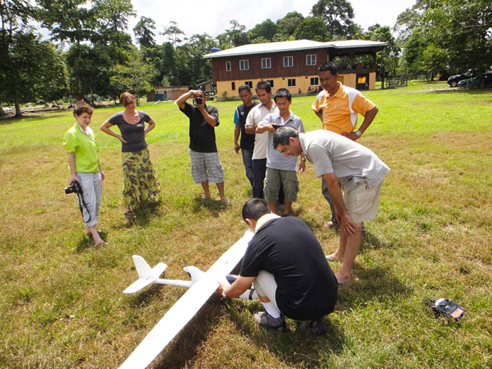
Serge Wich and Lian Pin Koh preparing a Conservation Drone for a demonstration mission for the French conservation group, HUTAN, near the Kinabatangan river in Borneo.

Why did we develop Conservation Drones?
Globally, biodiversity continues to decline, and a disproportional amount of this decline occurs in the tropics where the majority of global biodiversity is found. One urgent challenge for conservationists is to be able to accurately assess and monitor changes in forest cover, species distributions and population dynamics. To obtain such data, conservationists currently rely on satellite-based remote sensing for mapping and monitoring land use changes, and on ground surveys to determine and monitor species distribution and population dynamics. Although low-resolution satellite images are freely available at specific time intervals, it is often prohibitively expensive to obtain sub-meter resolution images. Yet, such high-resolution data are often critical for accurately detecting and tracking land use change at the landscape scale. Furthermore, large portions of the humid tropics are often obscured from remote sensing satellites due to persistent cloud cover. As such, cloud-free satellite images for a specific time period/series and location are often not readily available.
conservation_drone_elephant_detection

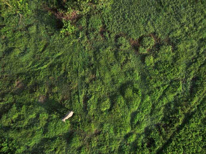
An elephant detected during one of the drone missions in North Sumatra, Indonesia.

A second major conservation challenge concerns assessment and monitoring of biodiversity. Currently, this is largely achieved through ground surveys, which are often time-consuming, financially expensive, and logistically challenging in remote areas. As a result, surveys are not conducted at the frequency required to monitor population trends, and some remote tropical forests have never been surveyed for biodiversity due to difficult and inaccessible terrain.

An additional challenge for conservationists is the illegal encroachment into protected areas and illegal hunting of prized animals, such as tiger, rhinos, and elephants. The areas that need to be surveyed in these cases are large, and current ground and manned aircraft surveys do not occur regularly enough to be able to effectively reduce illegal activities.

To address these challenges, we are developing the use of inexpensive, autonomous unmanned aerial vehicles for surveying and mapping forests, biodiversity and potential illegal activities – Conservation Drones.
conservation_drone_cambodia_forest

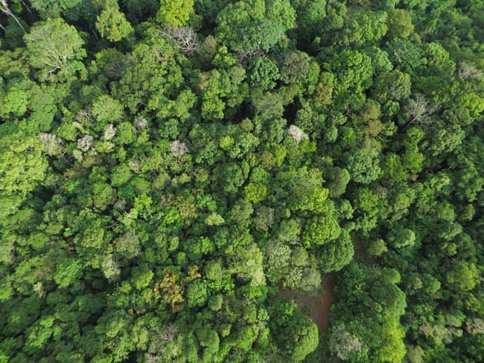
Drone image of a forest in Cambodia.

What are Conservation Drones?
Although we have been using several airframes for our drones since we started, the core part of the system has remained the same. The core is an autopilot system (APM) developed by an online community (diydrones.com). By combining the APM with open-source mission planner software (APM Planner), we convert off-the-shelf model airplanes into drones. We use inexpensive airframes so that the technology can be accessible to conservation organizations and researchers, who often do not have the funding to acquire drones and maintain them.

The sensors
We have equipped our drones with various camera systems for still-photography and videography. We have been mainly using the Canon SX230 with a build-in GPS so that all photos are geo-tagged. We replace the original firmware of the Canon camera with aCanon Hack Development Kit. This ‘hacked’ firmware allows us to implement a customized intervalometer script to command the camera to take photographs at user-specified time intervals (e.g., every 3 seconds). This script also allows the user to define several other parameters including: i) time-delay before the camera begins taking pictures, ii) focal length of camera lens, and iii) time before camera automatically shuts down and retracts its lens.

We also use video cameras such as the GoPro Hero and the ContourGPS. These take high definition videos at 1080 x 720 pixels. We attached these cameras underneath or on the side of the fuselage. Using the APM Planner, we program the flight path of each mission by clicking on waypoints in a Google satellite map interface. The drone can be programmed to take off and land autonomously, and circle over any waypoint for a specified number of turns or duration. Users could also program other flight parameters such as ground speed and altitude of each waypoint.
conservation_drone_mosaic

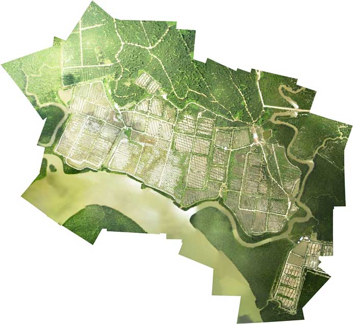
A mosaic of drone images during a mission over an agricultural landscape in Sabah.

What have we achieved so far?
Since our start in January of this year we have made over 200 conservation drone flights in several countries including Switzerland, Netherlands, Indonesia, Malaysia and Nepal, Congo, Gabon, Madagascar, United States, and Greenland. These flights have provided us a large amount of photos and videos, which we have examined with respect to our three main initial goals. We describe these below.

Mapping land use
So far we have been able to take sets of high-resolution photos of various areas that can be stitched together into a geo-referenced mosaic so that it can be used in geographic information system software. Such mosaics give detailed information on type of land use, agriculture, and settlements. In addition, the images can be used to create three-dimensional models of the areas that were covered during missions due to the overlap between the photos. Such models can potentially be used to calculate a number of characteristics of different land uses such as tree height and tree density.

Biodiversity
The high-resolution nature of our images have also allowed us to detect various wildlife species on our photos or their signs including orangutans and their nests, elephants, rhinos, forest buffaloes, and even turtle nests. The next important step for our work is to derive the distribution and density of these wildlife species based on drone images so that this technique can become a standard application for conservation workers. To achieve this goal, we are collaborating with colleagues, including Prof. Dr. Andreas Krause at ETH Zurich to automate the detection of orangutan nests.

Illegal activities
For conservation workers, having access to up-to-date information on illegal logging in protected areas and poaching are extremely important. The video and photos taken from the drones can be used to detect such these illegal activities. For example, geo-tagged drone images of recently logged areas could help authorities track down illegal loggers and provide evidence for their conviction. When poachers are in a forest, they often create campfires for cooking or smoking the bush-meat from animals they have hunted. The detection of smoke rising above a forest would thus be very useful to locate these poachers. Conservation drones equipped with a high definition video camera could facilitate the detection of smoke many kilometers away. Furthermore, a ‘live’ video link would allow rangers to patrol the forest in real time, and react immediately when needed.
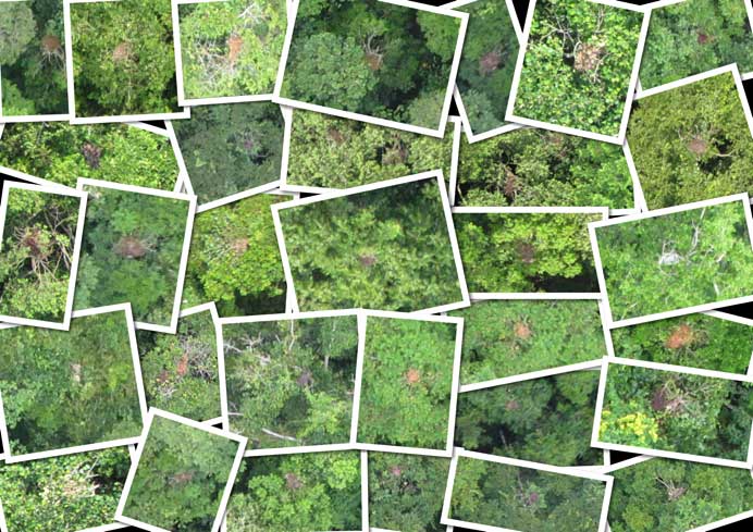
conservation_drone_orangutan_nests

Drone images of orang-utan nests acquired during missions in Southeast Asia.

Plans for the future
Conservation Drones is a constant work in progress. We are currently working with other colleagues to explore the use of our drones as a ‘data mule’. For example, drones equipped with a scanning radio receiver might be able to triangulate the location of forest animals that have been tagged with a radio collar. This would be a much more efficient way of locating these radio-collared animals than the traditional method of walking the forest on foot with a cumbersome radio antenna.

We are also working with WWF Nepal and India to equip drones with thermal imaging cameras. These camera systems would be able to detect heat emitting objects from the ground, which would help rangers locate both wildlife and poachers at night.


Further Reading
Koh, L. H., Wich, S. A. (2012) Dawn of drone ecology: low-cost autonomous aerial vehicles for conservationTropical Conservation Science 5: 121-132.

www.conservationdrones.org

Read more…

Tinkering with Neopixel LED-strips

During my LED-googling, I also ran across the Neopixel light strips. Those are strips made of WS2812 LEDs - RGB LEDs with integrated 2811 controller. Thanks to Adafruit there also is a control library, which makes it reasonably easy to control those things with an Arduino.

Here is an idea of integrated navigation and anti-collision lights for a quad:

4 segments, 1 red, 1 green and 2 white for left, right and rear arms, showing navigation colors and doubling as an anti-collision strobe. Those WS2812 are not immensely bright but hey - nobody said you can only use 3 per arm :).
And they probably work great for a plane too, just put half a meter of strip to every wing. That IS gonna be bright.

US-residents probably best get the strips from Adafruit. If you are in Europe, KT-Electronic's eBay-shop should be the right address.

Read more…

RTF Hexacopter from Event 38 - Aphex

3689529600?profile=original

I’m happy to announce the release of our first multirotor drone at Event 38, the Aphex aerial photography platform. This hexacopter is based on the 3DR Hexa frame. It comes ready to fly with a 2-axis stabilizing camera mount for taking aerial photographs. We modified the camera mount so it can now take images not only at moderate angles but also straight down for super low altitude mapping missions. You can easily make small mosaics with resolution less than 0.5cm/pixel. Aimed straight forward, the Aphex can be used to take amazing oblique aerial shots of houses, landscapes and large structures.


The Platform:

The Aphex is based on the 3DR Hexa-B frame using the larger 880kV motors and 11x4.7 propellers. APM2.5 with uBlox GPS are included. The pre-configured tilt/roll stabilized camera mount keeps your cameras up to 500g shooting straight and level. Adjust the tilt axis any time from your R/C controller. The 3DR battery monitor warns you when the battery is low on charge.


3689529632?profile=original

The Possibilities:

-          Mapping – Great for small but extremely high quality maps, up to 20 acres per flight

-          Inspection – Bridges/Buildings/Rooves

-          Photography – Get a vantage point above pole cameras and below helicopters

-          Planning – Construction, Mining, Logging, any large scale outdoor operation can benefit from a periodic, "big picture" vantage point.


For those who want really high quality images from an aerial vantage point and don’t like the distorted look and curved horizon you get from GoPro, we’ve sized the Aphex to carry larger traditional cameras. Mount your own or choose one of our Canon Powershot SX260s for medium resolution (12.1MP) and to have your images automatically geotagged. For very high quality images, we offer an automatic trigger system for Samsung mirrorless cameras, the NX1000, NX20 and NX210. These cameras are a great blend of DSLR quality images (20MP APC-C sensor) and lightweight bodies compatible with aerial use.

Check out some of our images below or see more here: http://droneyard.com/aerial-shots/

3689529660?profile=original

3689529703?profile=original 

Click here to read more about the specifications or to order now.


Please leave your questions or comments below and also feel free to message me directly through DIY Drones or by email at Jeff@Event38.com. If there's any interest, I'll make another blog post detailing how to trigger Samsung NX cameras from APM.

Finally I'd like to thank the 3DR and uDrones teams and especially the ArduPlane, ArduCopter and Mission Planner dev teams, thank you!!

Read more…