Drones, lights and nature combine in Drone Courtship, a short movie about a magical encounter between two flying robots set in a forest of centennial trees. A collaboration between Atelier D. Schlaepfer and Flyability, and filmed without special effects, the movie shows how robots can transform onscreen into living creatures.
All Posts (11086)
Sort by
The SF00 long range laser altimeter
Measurements of the height above ground up to and beyond 250m (820 feet) provide important information to many different types of aircraft. For commercial and military drones operating beyond line-of-sight or light aircraft and helicopters operating in uncontrolled airspace, knowing the height above ground is a critical safety requirement. Accurate AGL measurement is also important for precision photographic work in surveying and wildlife conservation.
Our new SF00, long range laser altimeter includes some interesting features that provide high reliability data even under difficult operating conditions. The long range capability can increase the chance of detecting background noise and the requirement for redundancy in critical systems means that the SF00 has to be able to recognize it’s own laser signature against a background of similar signals. Addressing these challenges has lead to significant improvements in laser altimeter performance for mission critical applications.
Under normal conditions the signals detected by a laser altimeter are clean and have a high SNR so measuring the time-of-flight to centimeter precision is no difficulty. In the image below the blue trace shows the “measurement window” during which a return signal is expected and the yellow trace is a typical return signal. Signals outside the measurement window are ignored.
Clean return signals inside the measurement window
In situations where extreme background light and high temperatures are experienced, noise in the form of stray photons or high energy electrons can create interference on the return signal. Internal control systems continually monitor this noise and make adjustments to the amplifier circuits to minimize its effect but there is always some residual noise in the system. Differentiating between this random noise and the return signals is critical to getting stable results. The SF00 does this by performing a statistical analysis on groups of measurements to establish their standard deviation. Groups that contain noise have a higher standard deviation than groups containing clean signals.
Noise due to background light and temperature effects
In high reliability systems it is not uncommon to use two laser altimeters aimed at the same point on the ground. Under these conditions it is possible for one unit to detect the return signal of the other since the lasers have the same wavelength and firing frequency. The SF00 deals with this in two ways:
Firstly, there is a “channel selection” that changes the firing frequency of the laser. This reduces the probability of the return signal from one unit showing up in the measurement window of the other. However, there is still a finite probability that a subharmonic of the different firing frequencies will continue to permit crosstalk.
The second approach is to randomize the laser firing frequency. This introduces “spread spectrum” like properties into the return signals increasing the probability of “self identification” whilst giving external signals the properties of random noise, and as mentioned above, the SF00 has a method of identifying and removing random noise.
Cross-talk in a high reliability application
At the limit of performance, it is possible to have a weak return signal mixed with random noise and cross talk from other lasers. The SF00 handles this by adding another layer of analysis that examines groups of results and makes a decision on the most probable altitude. If the probability is too low then it finally surrenders and warns of a lost signal condition.
The SF00 includes USB, serial and analog interfaces along with two set point alarms. Power is +5V at 250mA or USB and the maximum measuring range is > 250m at a resolution of 3cm.
Thanks for reading, L.D.
As some of you may know, we’ve designed Erle-Spider to deliver an open, low cost and Linux-based robot powered by ROS that hopes to bring robotics to many. To show it to the world we’ve put together a little game. Here’s how it works:
Erle-Spider is crawling around our offices and life streaming video of what it sees at https://www.youtube.com/c/ErleRobotics/live. The robot can be moved around with the following commands actioned through Twitter:
@ErleRobotics make #erlespider go [forward | backwards | right | left]http://igg.me/at/erle-spider/x/7817776
For example if I were to move the Spider forward to meet part of the team behind it I'd go and tweet: "@ErleRobotics make #erlespider go forwardhttp://igg.me/at/erle-spider/x/7817776" (note that YouTube imposes about 30 seconds of delay on the video feed).
We'll be making this little game available in our office hours (CEST). If you're interested in getting one for Christmas go to our indiegogo campaign and support us.
Thanks,
The passing of the autumnal equinox provides more opportunity to test luminary robots. Over the last few years, at about this time, I find myself deep in lighting experiments for upcoming projects. It's important to test any candidate lighting systems to understand how they might affect the autonomous flight characteristics of each aircraft: EMI, power consumption, flight stability, agility, longevity, etc....
On Sunday night, I attached lights to two TeensyFly Quads and a TeensyFly Hexa to test them in multi-aircraft autonomous flight. Here's a video of those two flights. These are flying robots, no joysticks were harmed in the filming of this video. Enjoy!
One of the great things about using drones to map areas is that you can do the same mapping mission many times, showing change over time. But it's sometimes hard to merge that data into Google Earth for viewing. Thankfully, the team at the Google Earth blog have created a Java utility to help you do that.
For the ‘Sorted by country’ section, we want to combine the new outline with the old outline removing the shared border.We already have the outline of the old extent of the 3D imagery (region 1) and we need two new outlines, one of just the newly covered area (region 2) that we use in the timeline and one showing the total area now covered that is used for the ‘Sorted by country’ section. So we want two new Polygons, one using segments 3 and 4 and another using segments 3 and 5.
It is possible to draw one of the new Polygons by starting with the existing polygon (1) and deleting the points in either segment 4 or 5 and then drawing segment 3. However, it still means that at least one segment of an outline needs to be redrawn. What would be ideal is to take a segment of the already existing outline and combine it with segments of the newly covered area outline. However Google Earth has no easy way to do this. So we have written a bit of JavaScript to accomplish the task and we thought that it might be something that other people who work with KML regions might find useful so we decided to share it.
To use our merger utility, first make sure you have two Polygon outlines that share a common border. Remove all points from the common border except the two at the ends of the shared border for each Polygon. Save the two polygons either in two separate KML files or a single KML file. Upload them below, then click the ‘Download merged Polygon’ button. Open the downloaded file in Google Earth.
It has not yet been tested very thoroughly so if you find any bugs please let us know in the comments. One problem that we encountered is that Google Earth Polygons may go clockwise or counter clockwise, so when combining two polygons by simply concatenating the list of points, it is possible to get a figure 8. We have tried to check for this and automatically correct it.

The Humanitarian UAV Mission I spearheaded in Nepal a couple weeks ago was just featured in the Washington Post. For more information on the mission and many more pictures, please see this write-up: Aerial Robotics in the Land of Buddha. This mission is an important milestone for Kathmandu Flying Labs, a UAV innovation lab I'm setting up in Nepal with local partners. More on this in the links above. I just gave a Keynote at UAV Expo 2015 this week in which I highlighted this project and invited UAV experts to partner with us in future missions to Nepal and elsewhere. So please consider this an open invitation to the DIYdrones community as well. If you are interested in applying your expertise for the better good, then do please get in touch: patrick@UAViators.org. More on our humanitarian efforts at UAViators. Thank you!
I had this idea in mind for a long time now, and when I heard about the Mimic from Freefly, I decided to do it for real. This is also part of some small projects I did about all the ways you can connect an Arduino to your radio transmitter to extend his capabilities.
So let's start with the Mimic, you can see here in action:
To do the same, I generate the gimbal movements based on a radio transmitter movement. On the transmitter side I use an IMU (which includes a gyro and accelerometer) to control a gimbal. For a single operator, this IMU could be located on the radio transmitter. Or you can put it on the FPV screen for a dual operator mode. Or you could even pilot your copter/plane with it !
The IMU output is converted into PPM signals by the Arduino and then sent to the transmitter through the trainer port.
Shopping list :
- An Arduino (Pro Mini 5V 16Mhz for small size)
- An IMU MPU6050, here I use a GY-521
- A connector for the trainer port, depending on you TX
- A battery and a 5V regulator
Warning : The Arduino Mini exists in 3V and 5V. I am using the 5V one. In theory, the MPU6050 (gyro and accelerometer?) has to be configured with 3V instead of 5V. But it working perfectly with 5V and the PPM signal is 5V.
And 5V version run at 16Mhz, twice the speed of the 3V version.
Connection
The only one difficult point here is that the Arduino Mini does not have SDA and SCL connectors, which are required for the I2C communication with the MPU6050. So you have to solder them by yourself.
Here is the cabling: 
The Power and PPM signal are not visible here, for simplification purpose.
- the Power is 5V, depending on your Arduino Mini.
- The PPM signal is on the connector 3.


Source Code
The source code is a basic merge from Jeff Rowberg i2cdevlib code for the MPU6050 and the one from Hasi on RC Groups about the PPM signal.
I had put my sources on Github : diymimic.ino.
Feel free to improve it, it is just a quick and dirty proof of concept. Use at your own risk !
Let's try it !
Note : You have to wait a few seconds for the auto-calibration.
Here is the result, fisrt with a gimbal and second with a quadcopter !
Who am I : I used to be a computer engineer flying RC plane in the week-end since I was a kid. I have now co-funded a drone company in France, Neo-Robotix, where we do survey, 3D Reconstruction and other stuff with copter and airplane running APM. Thanks to the DIY Drones comunity to make it possible.
French version available on my french blog.
The U.S. Department of Transportation’s Federal Aviation Administration (FAA) today announces the largest civil penalty the FAA has proposed against a UAS operator for endangering the safety of our airspace.
The FAA proposes a $1.9 million civil penalty against SkyPan International, Inc. of Chicago. Between March 21, 2012, and Dec. 15, 2014, SkyPan conducted 65 unauthorized operations in some of our most congested airspace and heavily populated cities, violating airspace regulations and various operating rules, the FAA alleges. These operations were illegal and not without risk.
The FAA alleges that the company conducted 65 unauthorized commercial UAS flights over various locations in New York City and Chicago between March 21, 2012 and Dec. 15, 2014. The flights involved aerial photography. Of those, 43 flew in the highly restricted New York Class B airspace.
“Flying unmanned aircraft in violation of the Federal Aviation Regulations is illegal and can be dangerous,” said FAA Administrator Michael Huerta. “We have the safest airspace in the world, and everyone who uses it must understand and observe our comprehensive set of rules and regulations.”
SkyPan operated the 43 flights in the New York Class B airspace without receiving an air traffic control clearance to access it, the FAA alleges. Additionally, the agency alleges the aircraft was not equipped with a two-way radio, transponder, and altitude-reporting equipment.
The FAA further alleges that on all 65 flights, the aircraft lacked an airworthiness certificate and effective registration, and SkyPan did not have a Certificate of Waiver or Authorization for the operations.
SkyPan operated the aircraft in a careless or reckless manner so as to endanger lives or property, the FAA alleges.
SkyPan has 30 days after receiving the FAA’s enforcement letter to respond to the agency.
http://www.faa.gov/news/press_releases/news_story.cfm?newsId=19555
Finally getting around to posting about our successful test of our Multi-Point Repeater aircraft last August.
Basically we were able to fly a Quad Mission relaying the mavlink data via our repeater aircraft, itself in an autonomous mission 400ft above. Both the Quad & Fixed wing data were fed through the repeater and were displayed simultaneously on Mission Planner.
The Repeater was made up of a RFD900 (MPSiK V2.5 firmware) and a 3DR 900mhz radio wired directly together. The Rx/Tx and RTS/CTS pins crossed over, powered by a separate battery and mounted on the wing of the fixed wing aircraft.
The Quad & Fixed Wing both had RFD900 with multi-point firmware. The Ground Control Station had a 3DR 900Mhz Radio.
The RDF900s were on the 915-922Mhz frequency range and the 3DR Radios 923-928Mhz. 50 Channels hopping. Both the RFDs and the 3DRs were on separate Net IDs.
The repeater seemed to work well during the whole mission with the Quad mission completely controlled via Mission Planner.
We’re excited to announce that our subscription based CADDrones.com community is now FREE for anyone to join. All members now have full access to every page and feature free of charge. Now that we are no longer subscription based we will not have the available resources to hire contractors for the needed positions. Our goal is to make CAD, 3D Printing, and Drones come together and build an amazing community and tool that is useful for people of all skill levels at the same time. We’re currently in the process of applying for an Open Source License with the “Open Source Initiative” at OpenSource.org! We need help from anyone who has been through this process or is willing to volunteer efforts into helping us draft a perfect Open Source License for our community.We’re hoping that as our FREE community grows our members will find interest in volunteering for one of the open positions below.
View our “old” announcement about CAD Drones going subscription based at: http://www.suasnews.com/2015/07/37535/caddrones-com-relaunched-as-subscription-based-open-source-cad-and-3d-printing-drone-community/
We’re looking at adding volunteers to fill all these positions by April of 2016:
Wiki Admin – Community Admin – Chat Rooms Moderator – Buy, Sell, & Trade Admin – Events Admin – 10x Expert CAD/3D Printing/Drone Specialists – 5x Wiki Hub Developers – 5x Community Moderators – 3x Web Developers – 7x Software Programmers
If you have any questions, suggestions, want to volunteer, or your company is interested in becoming a sponsor of the CAD Drones community reach out to us by visiting the “Contact Us” page on CADDrones.com and filling out our form.
Or contact:
Joshua Allen Johnson
Founder & CEO | CAD Drones LLC | Website: www.CADDrones.com
Phone: 612-559-9640 | Email: JoshuaAllenJohnson@gmail.com| LinkedIn: https://www.linkedin.com/in/caddrones
If you answered yes to both of those questions, then this post is for you.
I've always had a special fondness for the Sony QX-1 and decided to rig up a contraption that would let me fly her with Solo. For both of you on DIYDrones who are not familiar with the QX-1, it is a light (180 g body), high resolution (20MP), endowed with a large sensor (APS-C, 15x larger than GoPro) body that receives Sony E-mount lenses (including zoom lenses), and can be controlled by an extensive WiFi API.
First, I had to learn how to control the camera via the WiFi API. Jaime Machuca, of Droidika, wrote a nice MAVLink wrapper for the QX-1 API, but I never quite could get it going on Solo. Instead, I deployed the pysony API, which I installed on a RasPi that I taped to Solo's belly. This RasPi connected to QX-1's WiFi upon boot, ingested the mjpeg QX-1 livestream, pipe it over HDMI to Solo App, and triggered the QX-1 to begin shooting. I could control all other QX-1 functions on the ground, but I didn't have an easy way to integrate those controls into Solo herself.
Next, I had to gimbal the camera. At 280g with the 20mm flat lens and a bit more with the 16-50mm Power Zoom, a brushless gimbal was probably out of the question and would have been much more difficult and expensive to build up. Because I was mostly interested in stills, I didn't particularly care about smooth video, but rather wanted a horizontal horizon and the ability to tilt the camera. I selected the RC Timer CM102, which had no problem stabilizing the camera reasonably well and holding the desired pitch.
These two pieces combined succeeded into turning Solo into a reasonable, but kludgy solution to capture truly professional aerial images for either general consumption or the generation of high quality maps or models. However, while this project is functional, it is incomplete. This feat of engineering contains no fewer than two PixHawks, six batteries, 20+ feet of cable, two companion computers, five ESCs, 10+ feet of strapping tape, and two transmitters.
I would love some additional feedback and support from the community to potentially turn this weekend project into something that any Solo owner could enjoy. I have a few full resolution images from both the QX-1 and GoPro along with a video of this thing in action (on my desk) on my blog, to help you answer these questions.
1) Is this something you would generally want?
2) Is a servo gimbal a problem? Servos will never succeed at delivering high quality video, but seem quite capable of stabilizing the camera for stills.
3) Would anyone be willing to help me integrate pysony and appropriate WiFi boot up scripts into the iMX6, eliminating the need to carry a second companion computer?
After a couple months of testing by the community, Tower v3.2.0 has been released on the Google Play store for use by the general public!
This release requires the latest version of 3DR Services (v1.4.2).
The full set of changes can be found in the release notes but the highlights are below. If you find any bugs, please report them in the Issue Tracker here.
Tower Version 3.2.0 changelog:
- 3DR Solo support including:
- 3DR Solo video streaming
- 3DR Solo gimbal control
- Gopro control (requires compatible gopro connected to a 3DR Solo gimbal)
- Return to Me support:
- Ability to move the vehicle home location manually on the map
- Automatic update of the vehicle home location based on the mobile device GPS.
- Offline map support
- Telemetry widgets panel (right side panel) is now customizable:
- Addition of new telemetry widgets:
- EKF widget: allows live monitoring of the vehicle EKF state
- Vibration widget: allows live monitoring of the vehicle vibration state
- Geo Info widget: Displays vehicle latitude and longitude coordinates
- More to come...
- Improved Mission Editor UI:
- Added Spline Survey mission item
- Added DO JUMP mission item
- Mission assistant detail window:
- Display mission progress
- Allows rewind and/or fast forward of mission waypoints.
- Improved plane support
- Kill switch support for Copters
- Custom altitude preferences
- UI update to reflect the latest Android UI guidelines
- And many more small features, and lot's of bug fixes!
Special thanks to Randy and members of the ArduPilot developers community for helping shape the set of features for this release.
Thanks to all members of the beta testing group for helping iron out all the problems and bugs!
Notes: To get access to the beta releases, please follow the instructions @ https://play.google.com/apps/testing/org.droidplanner.android.beta
From the latest issue of Make Magazine, a great profile of the Syria Airlift project, which is using inexpensive APM:Plane powered aircraft to train refugees to deliver food and medical aid in Syria and other war-torn places:
On March 16, barrels of chlorine gas rained down on the town of Sarmin in northern Syria, killing six and wounding many more — just one of many horrific chemical attacks in the civil war that has consumed the country.
“Sarmin isn’t far from the border but the border is closed to all traffic,” Sasha Ghosh-Siminoff, president of Syrian aid organization People Demand Change, texted his Stanford University-based friend Mark Jacobsen, four hours after the attack. “If your planes were ready, you could have flown in emergency medicine and gear.”
The planes Ghosh-Siminoff was referring to are drones, built expressly for this purpose. Jacobsen is the executive director of Uplift Aeronautics, a nonprofit which hopes to deliver essential medical supplies, food, and other cargo to Syrians via its Syria Airlift Project. Syria recently closed its border to foreign aid, and any planes that attempt to fly over the country run a high chance of being shot down. Uplift has a different plan: Fleets of drones that could swoop in by night, undetected by human eyes or radars.
Jacobsen, who is pursuing a Ph.D. in political science, was in Istanbul about a year ago with a group of academics when a heated discussion broke out about international intervention in the Syrian war. Since 2011’s Arab Spring, when activists came together to protest president Bashar al-Assad and his government, at least 200,000 people have died there. More than 10,000 were children. A lack of medical care and food are among the government’s weapons against its own people.
Person after person at the gathering asked the same question: Why isn’t more being done? Jacobsen, a former Air Force cargo pilot, explained to one attendee that you simply can’t fly a cargo plane into such an unpredictable place. It’s impossible.
He went back to his hotel that night feeling guilty. It didn’t seem like a good enough answer. While speaking with his colleagues, he became fixated on the idea of sending in large numbers of packages — perhaps via drone. He took out a notebook at around 2 or 3 a.m., the hope of sleep long forgotten.
“It seemed like I was onto something with the idea of swarming small packets, but I didn’t really know what technology could do that, whether it would be quadcopters or planes or catapults or anything else. Balloons?” Jacobsen says. “I was just trying to lay out everything I could think of.”
Uplift Aeronautics and the Syria Airlift Project were eventually born, and today Jacobsen and a group of volunteers are busy flying prototype drones. Their plan is to fly hundreds over the border from a neighboring country on missions chosen by aid partners such as People Demand Change. Each can carry only a few pounds of supplies, but their small size makes them untrackable by radar and dispensable. If a chlorine bomb explodes, medicine-carrying drones can be there in an hour, as opposed to days — or never.
Uplift plans to train Syrian refugees and other people on the ground to fly and repair the drones. Its first destination would be Aleppo, Syria’s largest city. The war has hit it hard. Hunger and disease are common.
The drones would take about a half hour to fly to Aleppo. Instead of touching down, they would drop their cargo in a small box attached to a parachute. Then they would return. Back at the launch base, the location of which would likely shift from day to day, volunteers could switch out their battery, load new cargo, and launch again within minutes.
Flying anything, let alone hundreds of drones, into a country without permission is a breach of international law. Current sanctions bar sending U.S. goods into the country. In extreme times like these, exceptions can be granted, but they depend on various government channels.
Jacobsen isn’t exactly sure how Uplift will secure an OK from the U.S., though he has initiated conversations with officials. The drones will likely have to be approved by the U.S. Treasury and international agreements, and will need to comply with arms regulations and counter-terrorism laws.
The local approval process could also be messy. Uplift will need to schedule audiences with the governments in countries bordering Syria, such as Turkey or Jordan. They will need to prove that the drones will be safe and beneficial. The recent election in Turkey, and the country’s air strikes within Syria, add a new layer of complexity.
Inside Syria, it’s actually the groups fighting Assad that would be most likely to shoot down a drone. Currently, it’s the resistance that occupies the ground between Uplift’s launch site and Aleppo. But if Uplift can demonstrate the planes are for aid, and will not interfere with the opposition’s efforts, Ghosh-Siminoff said there should not be a problem convincing the locals to let them pass.
In a country strapped for resources, a scenario could arise where troops start capturing drones to use for their own purposes. Uplift thought of that. The drones are equipped with a self-destruct device designed to fry their navigation system if they fly too close to the ground anywhere but at the launch site. Any drone that gets too low will never be remotely pilotable again.
“We’re not planning to talk to them at all once they leave the takeoff area,” says Jacobsen. “Routes will be pre-programmed. Our custom firmware on the plane actually plugs its ears and stops listening to incoming messages while in Syrian airspace, which should make it considerably harder to hack.”
On a hot, cloudless day in April, Jacobsen and four volunteers gathered at Stanford University’s Lake Lagunita. Engineer Michael Taylor, a Ph.D. candidate in electrical engineering, led two other volunteers through setting up the drone launcher on the lake bed, which has become a grassy field thanks to California’s drought.
On a porch overlooking the lake, Jacobsen assembled and tested the “Waliid” drone. He ran new volunteer Stuart Ginn, a medical resident still clad in scrubs, through the plane’s software and pre-flight protocol.
Made of foam and held together by tape, the drone is not visually impressive. It’s shaped like a plane, as opposed to the quadcopters that have taken over the consumer market, which allows it to fly for an hour instead of minutes. Its wingspan measures 5′ 7″ and is decorated in black, green, and red — the colors of the Syrian flag.


An interactive tool for designing quadcopter camera shots
SIGGRAPH Asia 2015
Cameras attached to small quadrotor aircraft are rapidly becoming a ubiquitous tool for cinematographers, enabling dynamic camera movements through 3D environments. Currently, professionals use these cameras by flying quadrotors manually, a process which requires much skill and dexterity. In this paper, we investigate the needs of quadrotor cinematographers, and build a tool to support video capture using quadrotor-based camera systems. We begin by conducting semi-structured interviews with professional photographers and videographers, from which we extract a set of design principles. We present a tool based on these principles for designing and autonomously executing quadrotor-based camera shots. Our tool enables users to: (1) specify shots visually using keyframes; (2) preview the resulting shots in a virtual environment; (3) precisely control the timing of shots using easing curves; and (4) capture the resulting shots in the real world with a single button click using commercially available quadrotors. We evaluate our tool in a user study with novice and expert cinematographers. We show that our tool makes it possible for novices and experts to design compelling and challenging shots, and capture them fully autonomously.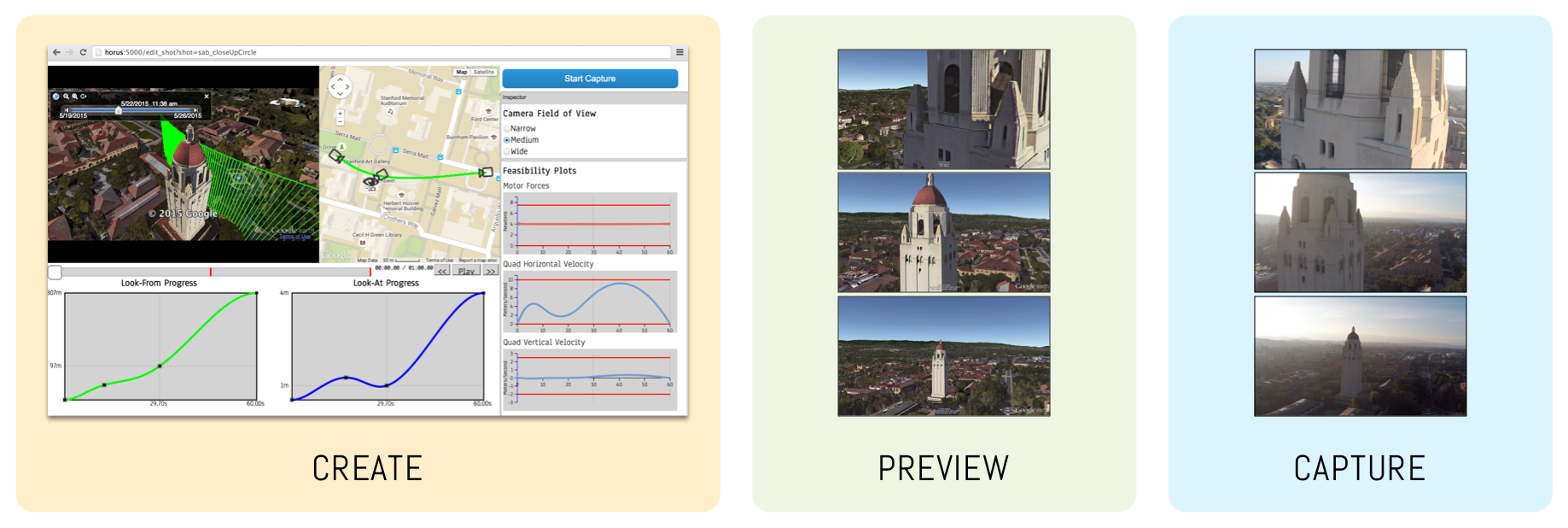

I stumble upon this thing today.
Could be a good (great?) camera platform for UAV.
What do you guys think?
Source: http://www.imaging-resource.com/PRODS/olympus-air-a01/olympus-air-a01A.HTM
More: Google: Olympus Air
============================================================

The front of the Olympus AIR A01 is pretty much all lens mount with the Micro Four Thirds bayonet flange (1), lens alignment mark (2), and locking pin (3) called out. You can also see the 4/3" sensor through the cover glass and the electrical lens contacts along the bottom.
Looking down at the top we can see a power switch (1), a large shutter button (2), stereo microphone ports (3), and a status LED (4). These minimal controls allow the AIR A01 to take quick snap-shots without the assistance of a mobile device.

Looking at the bottom, we see a standard tripod socket (1), the lens release lever (2), a speaker port (3), and a release lever for the AIR's own mounting flange (4). Not shown is a pair of threaded mounting points, located on the left and right sides of the barrel, occupied by little button-head screws, to keep them pristine and clean until you want to use them to attach the AIR to something.

And finally on the back with the protective cover removed, we can see the accessory mount flange (1), accessory mount locking pin (2), wireless radio on/off switch (3), microSD card slot (4), micro USB port (5), and a QR code (6) along with Wi-Fi SSID, password and Bluetooth device name printed on the label.

The Olympus AIR A01 includes an "AIR Coupler" accessory, which lets you mount a smartphone in landscape orientation at about a 45° angle. It supports a variety of smartphone sizes.
The product images above are all from Olympus. We normally replace the manufacturer's shots with our own once we have a camera in-hand, but in this case decided to leave the above, because they were so beautifully done, but also because the details are so much easier to see on a white body than the black one we received as an eval unit. (We were given a choice of white or black, but opted to go with black for improved "stealth" operation when shooting candids.) The product shots below are all our own, though.
Hi,
MatrixPilot got upgraded with the helical turn method. I changed my code to follow this development.
To add the auto land function, i needed better brake control. After that i created the auto landing script.
The codebase has moved to Git. My code is here: https://github.com/KeesGuijt/MatrixPilot
For more info and comments please go to
http://diydrones.com/forum/topics/atv-autonomous-thermalling
Regards,
GliderUAV
A quick recap of what is allowed in france :

We have been working for a few months to demonstrate to the DGAC that the SOLO was safe enough to be used for commercial operations. We had previously gotten the first type certificates for APM UAVs and Pixhawk UAVs like IRIS and IRIS+.

Can't wait to see the new SOLO update with all new features!

From Defense Systems:
The Army is experimenting with using swarms of small, inexpensive drones in battlefield missions—as much as anything because of the potential threat they could pose to U.S. forces.
Members of the Targets Management Office with Program Executive Office for Simulation Training and Instrumentation are using groups of quadcopters and octocopters to see what they’re capable of. The flights, part of an Army Test and Evaluation Command program to assess possible uses for and countermeasures against synchronized drones, are taking place at the ongoing Network Integration Evaluation exercises at White Sands Missile Range, N.M., and Fort Bliss, Texas.
"ATEC is our customer, they tasked us to come out and look at swarming, the variations and the payloads we can apply to this," James Story, an engineer with the Targets Management Office, said in a release. "We saw this as a threat that wasn't being addressed and ATEC agreed."
These types of drones aren’t much of a concern at the moment, because of their small size, limited payloads, short flight times and the fact that swarming is pretty rare. And they’re not exactly armored. But the technology is improving, and their relatively low cost makes them more easily available to adversaries. "Right now there's hardly anyone doing swarms, most people are flying one, maybe two, but any time you can get more than one or two in the air at the same time, and control them by waypoint with one laptop, that's important," Story said. "You're controlling all five of them, and all five of them are a threat."
The Army points out that even small military drones, like the Tarantula Hawk micro air vehicle, used for surveillance, IED defeat and target acquisition, costs hundreds of thousands of dollars and requires extensive training to operate. A commercial quadcopter like the 3D Robotics Iris series being used in the tests, on the other hand, goes for about $1,000 and can be flown by anyone pretty much out of the box.
One reason I constantly check DIYdrones throughout the day is the tenancy to have well-written and informative blog posts on the front page, as opposed to some of the "hype machine news" found elsewhere, though we get our share as well.
This blog post is really intended to be "just a blog post". I have multiple half-finished and in progress blog posts started (all relating to this topic), and I always want to add a little more substance and evidence first, in an effort to contribute to the quality of discussions I admire here. In this case, I feel that it's important to urge a little movement in a specific direction and offer up some signature rambling.
I did not get into UAS/drones for agricultural purposes, but stumbling across the topic is inevitable. In the past year or so, most of my focus has been on the agricultural side of commercial UAS use. I have zero relevant background in this regard, which is exactly what qualifies me to write THIS specific blog post. While information on requirements and uses for multispectral cameras (ranging from low end to scientifically calibrated) is readily available in peer reviewed articles with case studies and examples, this information is often difficult to comprehend without dedicating a significant amount of time to learning it.
Holding true to our philosophy at the fire department, I've been attempting a "The best way to learn is to teach" approach by making my contribution to this community a guide on NDVI, based on referenced and verifiable studies that typically don't show up in a google search. The conversations I've been having are frightening.
The summary is "The NDVI capabilities of drones that is being marketed is, at best, a gross overestimation".
I really want that quote to sink in for a moment, because I have a different viewpoint on the implications. The bad side is that reputations like this have the potential to cause some involuntary career changes. The good side is that the problem can be solved by shedding some of our own ignorance, as the cause is really our lack of understanding. Thankfully, the above quote was followed up by a conversation about how some of the converted camera's many of us are using DO have a use, but it is critical to understand and implement some workflow steps, and there also needs to be an understanding of the biodiversity of the area of operations and how it pertains to the information you're trying to extract. That information needs to be understood to determine if your sensor's capabilities are able to extract it.
With limited understanding, many of these conversations with people experienced in remote sensing and agriculture (but without a stake in the UAS industry) scared the hell out of me. I've had ongoing interactions with people from almost every data processing company I can think of, as well as a few manufacturers. I'm really rooting for everyone to succeed and didn't want to start citing data that is detrimental to many efforts, especially with limited understanding myself and far less on-the-line than others. I still maintain that viewpoint, and this is the basis of my reasoning for writing this blog. The wide-spread belief of "Farmers can save $____ with drone-collected NDVI" is possible, and it is possible with a variety of camera options...but it's not possible without a widespread understanding and accountability for the steps that need to be taken for this data to be useful. Every drone-related agricultural service is going to contribute to the reputation of capabilities of others, because right now it is all seen as the same cup o' tea.
My initial plan for compiling this data for the average Joe attempting to get into a drones-as-a-service role has expanded to include much more information than I initially intended. I foresee this being a long process of learning myself and having the drafts reviewed by the people that have offered up their assistance, but I'd like to see some progress from others, big and small, to increase their understanding of the service being offered. You can justify the effort on the grounds of ethics, capitalism or self-preservation, but it's an essential step either way.
Hi
I would like to ask you for little help in making this drone real, if you could support the project that would be amazing, if you cannot help financially, but you would still like to be part of it, please share the campaign!
Link to the campaign: https://www.indiegogo.com/projects/b-unstoppable-world-s-first-tank-quadcopter-drone/x/11697128#/story
Watch B-Unstoppable in action: https://www.youtube.com/watch?v=pAfy_zBL1xE
Due to our patented solution (goo.gl/c7jq5u ) B-Unstoppable achieves outstanding performance in driving across difficult terrain.
It can turn on the spot, which is extremely useful in limited space, which in turn provides 360 view from the on-board camera. As well as driving on the ground, when obstacles become too big, it can simply take-off and fly over them. The model weighs only 84 g, therefore it can be operated, without the fear of causing damage to other models or itself.
Despite the small size and low cost, B-unstoppable is packed full of great features and technology you would usually only expect on more expensive machines.
The model recently was upgraded to:
- The top end FPV system, that provides true "no latency" experience! 8 channel 4.3 inch screen, with play back function
- New 8x20 motors that increased the flight speed to 35 km/h
Thanks
B
.
