All Posts (11086)

Sort by

3689672167?profile=original(More info and full post here)

I've been experimenting with putting 360 degree vision, including stereo vision, onto a Crazyflie nano quadrotor to assist with flight in near-Earth and indoor environments. Four stereo boards, each holding two image sensor chips and lenses, together see in all directions except up and down. We developed the image sensor chips and lenses in-house for this work, since there is nothing available elsewhere that is suitable for platforms of this size. The control processor (on the square PCB in the middle) uses optical flow for position control and stereo vision for obstacle avoidance. The system uses a "supervised autonomy" control scheme in which the operator gives high level commands via control sticks (e.g. "move this general direction") and the control system implements the maneuver while avoiding nearby obstacles. All sensing and processing is performed on board. The Crazyflie itself was unmodified other than a few lines of code in it's firmware to get the target Euler angles and throttle from the vision system.

Below is a video from a few flights in an indoor space. This is best viewed on a laptop or desktop computer to see the annotations in the video. The performance is not perfect, but much better than the pure "hover in place" systems I had flown in the past since obstacles are now avoided. I would not have been able to fly in the last room without the vision system to assist me! There are still obvious shortcomings- for example the stereo vision currently does not respond to blank walls- but we'll address this soon...

Read more…

sample-geofence-smaller.jpg?w=882

The UAV Challenge Technical Committee today announced that the venue for the 2016 UAV Challenge Medical Express competition will be Dalby, Queensland, Australia. The Base for the event will be the Dalby Model Aero Club (DMAC). A rules update was also launched today, with Version 2 of the rules now available on the Medical Express Page. A full list of changes to the rules can be found on page 5 of v2 of the rules document. Finally, it was announced today, that the date of the Medical Express event has been pushed back by one week (to 27 September 2016), along with the due date of the Deliverable 3. Please see the Medical Express page for further details.

Read more…

Parrot Bebop 2 : The new Parrot racing drone ?

Parrot-Bebop2_drone_dronemakers-1024x492-mi9girlp4xmtgxgo7weikkg8n7lrohz6nrwthi4gx8.jpg?width=500

Parrot unveiled the Bebop 2, new version of its drone out a year ago. The strange flying machine provides several new features, including enhanced autonomy.

Despite all the advantages of Bebop, this drone suffered from relatively poor battery life: 12 minutes. The new generation offers a bit more, even if we can find it always a bit light: half an hour (the manufacturer announced 25 minutes).

Other important new features, we benefit in this new quadricopter a top speed of 60 km / h , either 20 km / h more than the previous model. No doubt the device will quickly being popular among drones races fans.

For the rest, the Bebop 2 retains the 14-megapixel camera with HD recording and image stabilization, 8GB of storage, all of which are controllable from the mobile application. In wireless, the range is up to 300 meters, but can be up to 2 km with SkyController remote. Prices start at $ 550, with availability by the end of the year.


Read more…

3689672098?profile=original

This is the crazy project that kept us busy lately at Quaternium: a hybrid electric+gas multirotor with range extender, inspired by Hybrid cars, such as BMWi3.

Our goal is to overcome the endurance limitations of an electric multicopter, while keeping the multirotor platform we are so enthusiastic about. This VTOL UAV has 2.5 hr estimated flight time with payload, and around 4 hours endurance otherwise.

These are the product specs:

HYBRIX 20

MTOW

20.0 KG

EMPTY WEIGHT

11.3 KG

PAYLOAD

7.0 KG

ENDURANCE (FULL LOAD)

1.4 HR

ENDURANCE (NO PAYLOAD)

2.7 HR

CRUISE SPEED

80 KM/HR

SIZE (MOTOR TO MOTOR)

1350 MM

Why are we working on this?

As you all know, the drone market is only starting. We believe there will be many more  industrial applications emerging soon. With this new project, we seek to go beyond current technology limits and explore new possibilities of application.


What do you think about it? I’d love to hear your comments on this!

jlcortex

www.quaternium.com


Read more…
3689672004?profile=original
Hello all,

I am working on a VTOL concept and thought I would post it here.  I hope to get as much feedback as possible from anyone who has any.  The depicted airframe is the simplest embodiment that would be capable of both rotary and fixed wing flight.  Alternative versions could look very much like a conventional helicopter having a stationary fuselage and a very small tail rotor or control surface.  This is basically just my website copied and pasted.  This is a concept only at this point, no prototype. Also, the ducted fans were just for simplicity for the animation, not necessarily for the working aircraft.
Thanks for looking.

- Joe
Thank You,
Joe Renteria
3689672061?profile=original
Vertical takeoff
Transition to fixed wing flight
Transition to hover
Read more…
Moderator

agBOT challenge

3689671936?profile=original

No FAA to worry about on this one, I would like to think DIYD members could or even should win this....

Mission Statement

Identify and commercialize innovative agriculture husbandry technologies that improve work processes, as well as modernize observation technologies and intervention methods.

The Race is on . . .

The 2016 agBOT Challenge is a competition of teams to develop the most efficient unmanned crop seeder capable of planting two varieties of seed over half-mile-long rows, while providing real-time data utilizing a mobile tracking antenna. Participating teams, representing advanced robotics and agricultural research and development organizations, will develop the hardware, software, sensors, and human-machine control interfaces that enable their robots. Technologies resulting from the 2016 agBOT Challenge will propel both agriculture and the field of robotics.

The 2017 agBOT Challenge will be a competition for pest and weed identification and eradication.

The 2018 agBOT Challenge will be a competition for harvest method robotics.

Enabling and Engaging today’s Farmer

The need to produce food faster and easier in imperative; reliable labor is harder to find and wages are rising. While the agricultural field has gradually migrated toward farming supervision based on site specific crop management, the transition toward advanced robotics technology has been sluggish.

The 2016 agBOT Challenge will deliver a combination of progressive machinery with the software required to process data needed to virtually and economically manage crops. Unmanned seeding equipment through the usage of advanced communications systems will support all farmers!

The outcomes of the 2016 agBOT Challenge will be:

  • Equipment capable of providing real time data and analysis to farmers
  • Lowered cost of capital equipment
  • Innovation of new labor supply to the farm
  • Solutions to the availability of Precision Ag Software
  • Increased efficiency with rural high-speed internet access

Environmental benefits include:

  • Reduced carbon footprint
  • Less soil compaction
  • Decrease in erosion
  • Reduction in use of harmful chemicals
  • Diminished dependency on fossil fuels

Agricultural Robotics will decrease the volume of labor, and make farming faster and more accurate.

Agricultural Trailblazing through Technological Innovations

With a nine billion global population by the year 2050, the time has arrived to support our farmers with an infusion of today’s best resources. While there have been enormous advances in agriculture in recent times, we now need to progress our production and better safeguard our environment. Although agricultural machinery has witnessed a radical makeover from the days of a crude plow pulled by an animal, developing the means to more efficiently plant seed and provide husbandry to the crop is imperative. Evolution of agricultural practices allows for greater sustainability in a depleting world of farming circles.

airBridge is leading the charge in a Renaissance of farming, tapping into tomorrow’s greatest minds to solve today’s greatest agricultural challenges.

The 2016 agBOT Challenge will set the tone in the development of autonomous crop seeding which provides our future stewards the tools and technology that enables farms of any size to be successful.

There are many ways for you and your organization to become involved . . .

  • Register a Competitive robotics building team
  • Sponsor the 2016 agBOT Challenge
  • Exhibit at the 2016 agBOT Challenge
  • Partner or Volunteer with the 2016 agBOT Challenge
  • Attend the 2016 agBOT Challenge on May 7, 2016
  • Subscribe to our Social Media outlets to stay informed

http://www.agbot.ag/

Read more…
3D Robotics

New announcement from BirdsEyeView:

BirdsEyeView Aerobotics is proud to introduce AvA: Advanced VTOL Autonomy for the FireFLY6.  AvA is the culmination of a year of behind-the-scenes development and testing, producing a powerful, elegant single controller autopilot solution for the FireFLY6. 

AvA is flight control firmware, designed for the PX4hawk autopilot, that gracefully handles the FireFLY6 in all regimes – takeoff to landing.  Flight mode transitions from hover to forward flight (and back) are fully AvA-controlled, making transitions a simple matter of flicking a switch.  No special radio programming or piloting techniques required.

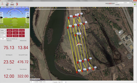
AvA also enables fully-scripted autonomous operations, where all flight behavior (including transitions) can be preplanned using map-based point-and-click commands in our custom interface, FireFLY6 Planner.

FireFLY6 Planner runs on your Windows laptop or tablet, providing a real time link to the aircraft via the telemetry radio set included with your PX4hawk.  This allows for continuous monitoring of the FireFLY6’s health and location as well as point-and-click retasking. 

In particular, we focused on making mapping missions with the FireFLY6 easy, with intuitive access to the necessary flight planning and image georeferencing tools in FireFLY6 Planner.  This makes the FireFLY6 a killer mapping platform when combined with our upcoming mapping camera mounts, which are compatible with the FireFLY6 Gimbal Mount Kit – giving your FireFLY6 mapping bird the flexibility to also excel in gimbal-based aerial observation tasks (aerial videography, search & rescue, powerline/pipeline monitoring, etc).

AvA is available now in three different flavors, defined by your choice of key.  AvA keys unlock different levels of functionality, each level aimed at a specific user group: Sport, Pro, and Mapping.  More information on AvA keys and the functionality that they unlock can be found here.

AvA and the FireFLY6 Planner are built on a foundation provided by the APM Project.  AvA is a heavily modified version of APM:Copter, stripped down to the simple essentials and tailored to the FireFLY6, incorporating a special brew of custom forward flight algorithms and select functionality borrowed fromAPM:Plane.  Similarly, FireFLY6 Planner is a heavily modified version of the APM Project’s Mission Planner, lovingly recrafted in BirdsEyeView Aerobotics style with the FireFLY6 as a centerpiece. 

As a result of AvA’s APM heritage and PX4 backbone, we’re also happy to announce our membership in theDronecode Project.  We look forward to being active members of the open source aerobotics community.

Say hello to the FireFLY6 with AvA Onboard.  Welcome to the Revolution.

Read more…
3D Robotics

3689671914?profile=original

It bears repeating: Drones Are Hard. Above are some stats on the projects I've backed. I don't regret funding any of them, since I like encouraging these sorts of projects and I learn a lot from their updates. When a crowdfunding project I've backed actually shows up, I'm amazed (I call this being "Kickstartled") and then usually a bit disappointed that it isn't as cool or useful as I'd hoped. But I admire the work that it took into getting that far, and I'll keep backing them. This is my charity work ;-)

It's worth noting that none of these have arrived yet (with the exception of the disastrous Pockedrone, the less said about the better), so these bars will rise. 

I've created a public spreadsheet here if you want to add to it. Screenshot from it below:

3689671984?profile=original

Read more…
3D Robotics

The Precision Hawk LATAS technology, which works with Pixhawk and APM-based drones to create static and dynamic geofences to respond to "airspace intrusions" around drones, will be field tested with the FAA this week. From Quartz: 

The FAA has been working since May with PrecisionHawk, a company that builds commercial drones for aerial surveillance and data gathering, to figure out how to keep the skies safe. The company will carry out the tests in North Carolina using an avoidance system it developed, called LATAS, according to MIT Technology Review. The first test will involve an aircraft—in this case, a rather brave paraglider—being flown near a drone operated by a human pilot to test how quickly the pilot can react to the paraglider getting up in their airspace. A later test will involve the same situation, but will use a drone connected to the LATAS system, which should act as an early-warning detection system for the pilot, and potentially help the drone avoid objects on its own. LATAS uses satellites, location sensors, and Verizon’s cellular network to triangulate itself.

“We want to measure the ability of a person flying the drone looking for airspace hazards visually against letting the drone make some decisions,” Tyler Collins, who leads the LATAS work at Precision Hawk, told MIT Technology Review.

Further down the road—literally—PrecisionHawk and the FAA will test out flying drones using LATAS in situations where the pilot can’t see the drone. Most consumer and small commercial drones have ranges of a few miles—much farther than any human can see. These tests could pave the way to drones being remotely operated by pilots for Amazon or Walmart, or any other company looking to use drones commercially.

More from Technology Review here

Read more…
3D Robotics

Don't use GPS for odometry!

3689671954?profile=original

Very interesting research that shows that the statistical errors build up with GPS in a way that exaggerates distance traveled. Counterintuitive!

Have you had a suspicion that your GPS app is overestimating the distance traveled? If so you are probably correct but the reason isn't an algorithmic glitch. The answer lies in the statistics and it is a strange story. 

The mathematics of GPS position finding are complex enough to be left to a code library, but lots of apps will take a set of co-ordinates and work out the distance between each adjacent pair on a path to work out the total distance traveled. 

This is so simple and so intuitive that it is hard to see how it could possibly go wrong, but it does.

If you start thinking about how this algorithm could give you the wrong answer then your first conclusion might be that interpolation error might dominate. After all the user is taking a curved path through the world and your GPS calculation is approximating this curve with a set of straight line segments. A moment's thought should reveal that this suggests that the GPS distance will be less than the true path. This is correct, but in practice GPS measurements are taken often enough to make interpolation error small. 

The reason is all down to the errors in the positions and how these errors accumulate.

If you make a measurement and it is subject to a random unbiased error then you generally are safe in assuming that the random component will make the quantity larger as often as it makes it smaller. This is how it seems to be with GPS  there are errors in positioning that are inherent in the system but certainly don't show any particular bias. Given this observation you would expect the distance between two points located with unbiased random error would also be unbiased, i.e. it would be on average bigger as often as it was smaller than the true value. 

However, you would be wrong. 

Researchers at the University of Salzburg (UoS), Salzburg Forschungsgesellchaft (SFG), and the Delft University of Technology have done some fairly simple calculations that prove that this is not the case. Irrespective of the distribution of the errors, the expected measured length squared between two points is bigger than the true length squared unless the errors at both points are identical.

That is, if you have two points p1 and p2 and errors in measuring x and y at each, the squared distance measured between them will come out as bigger than the true distance unless the errors are such that they move both points by the same amount - which is highly unlikely in practice.

How can this be? 

Consider the two points and the straight line between them. This straight line is the shortest distance between the two points. Now consider random displacements of the two points. The only displacements that reduce the distance are those that move the two points closer together, for example displacements along the line towards each other. The majority of random displacements end up increasing the distance. 

This is the reason that unbiased errors end up biasing the distance measurement. 

So given that the GPS path is just a sum of distances computed between pairs of points, the total estimated distance is going to be bigger than the true distance because of random errors.

A little more work and the researchers derive a formula forhow much of an Over Estimate of Distance OED is produced:

OED= (d2 + var - C)1/2 - d

where var is the variance in the GPS position and C is the autocovariance (correlation) between the errors. Notice that the more correlated the errors, the smaller the over estimate. 

To test the theory some experiments were performed. A consumer quality GPS was walked around a 10m square with segment lengths of 1m and 5m. The average measured segments were 1.2m and 5.6m. That is, an overestimate of between 20% and 60%. Clearly a smaller segment length is a good idea.

Is there anything to be done?

The researchers point out the measurement of speed is not subject to the same problem. GPS devices can measure speed using Doppler shift and this is accurate and not subject to the same measurement bias. It might well be that you can get unbiased distances by integrating velocity measurements over time. 

Runners and other athletes have long complained that GPS devices overestimate their performance and there have been lots of suggestions as to why.

This research does seem to have come with the answer - statistics. 

More Information

Peter Ranacher, Richard Brunauer, Wolfgang Trutschnig, Stefan Van der Spek & Siegfried Reich (2015): Why GPS makes distances bigger than they are, International Journal of Geographical Information Science, DOI: 10.1080/13658816.2015.1086924

Via Robohub

Read more…
Moderator

The future is here after over two years of work can be said to have developed in the laboratories of Laser Navigation and thanks to the support of the network of laboratories Virtualrobotix drone technology of tomorrow.
A short video of a recent test test of our system of autonomous flight, mapping and advanced management of the payload.
In the video you can see to your left the management of telemetry and live images from the drone, during production of photogrammetry high definition of this shed, on the right instead you can see the anti collision system , mapping and location on board the drone, working in 3D mode, totally alternative to the GPS with an accuracy of 5 cm. Integrated into our VR Brain Core  flight control.
The system is able through modules VR SLAM and Payload managment to fully manage a mapping mission indoors and inspection giving results very impressive.
The localization module that we have implemented is fully compatible with automated features that normally are handled with GPS. So in fact allows both the flight assisted by Lidar that autonomous navigation with impressive precision than a standard GPS.
This new architecture named VR  Goliath it  is compatible with different types of frames is that copter trad hely, but also boat or plane depending on the component and makes' the supply to professional customers and advanced R & D. Soon we are planning at the Technical University of Padua, a faculty Aerospace Professional Seminar dedicated to students, researchers and High Tech companies  where they will present the results of these research activities and will experience first hand the latest innovations born out by our lab ... . different professional customers have begun to use these technologies and our feedback from the field in real situations have confirmed the quality tested in our laboratories. To access more information on the platform you can contact me at r.navoni@virtualrobotix.com .

original post : http://www.virtualrobotix.com/profiles/blogs/vr-goliath-framework-integration-of-apm-ros-slam-and-payload-mana

Read more…
Moderator

3689671755?profile=original

3689671680?profile=original

3689671721?profile=original

These are the first two ready to flight prototype picture of VR Brain Core .

Are available for OEM and Beta tester different configuration of board with STM32F4 or F7 and with some additional connector like USB / SD Card or without connector that normally are available on custom distribution board.

Actually we are working at the first custrom distribution board for our VR Wasp , the ultra light complete drone compliant to under 300 gr drone for urban enviroment .

3689671742?profile=original

This is a picture with comparison between VR Brain 5 , VR Brain Core 6 and VR uBrain 5 as you can see the design of the core is adapt for fast protyping and for simple integration inside custom design.

3689671777?profile=original

For check the new VR Core 6 on air we decide to use this simple frame in 5 minutes we replace the VR uBrain and test the new board . 

In the video you can see the result of first flight ... It's impressive :) 

All the APM firmwware normally available for VR Brain 5 : Copter, Standard Hely , Plane , Rover , Boat it's available for VR Core. 

Here will be more information about the new OEM board : 

https://vrbrain.wordpress.com/

For VR Core there is a porting of Cleanflight by TommyLeo 

https://vrbrain.wordpress.com/quick-start-guide/speedyflight-2-31-multiwii-32-by-tommyleo/

We are discussing with Alessio Morale one of the founder of Libre Pilot project for support it inside his project.

I hope that you like this new design. It's not a replace of vrbrain and vrubrain but it's for OEM and special custom design where the integration is the must .

The board is only 5 grams 

for more info contact me at : r.navoni@virtualrobotix.com 

Best

Roberto Navoni

Read more…

3689672692?profile=original

Hello everyone. Long story short we are a small group of enthusiasts, who started to develop drones, payloads and accessories. Why we decided to do so? Because everything that were our there on the market was either too expensive or couldn’t satisfy our needs. We started with simple hobby equipment available online. Simple, but already tested before us. Because we needed to fulfil gap in number of drones really quickly we didn’t have enough time to jump in to the development of our own solution. Even though our first drones were not really good some of them are still operating after more then a year of service in really though conditions. About a year ago we started to develop of our own solutions. Right now we have a small UAV, a few gyro-stibilized platforms and a quadcopter. You can see all of them on our website www.ukrspecsystems.com. ;
One of the things that we made from scratch is our quadcopter named PC-1 (http://www.ukrspecsystems.com/products-view/quadcopter-pc-1/). Foldable frame with integrated two-axis gyro stabilized gimbal with 10x EO day-view camera. 30 minutes fly time and 5 km range. Not much to tell about it. Simple and reliable. We crashed it a few times during tests. It felt from about 30 meters multiple times and all damages were only to props and gimbals. Probably this particular drone just lucky or because of the foldable frame it observes the force from the impact. We made a short video to show how it work. Hope you guys enjoy. If you have any questions just write in comments. Thanks.  
Read more…

3689671575?profile=original

Drones have become an important tool for conservation work and we have seen them applied in game counting in Kenya, seal monitoring in the Arctic and for anti-poaching work in Southern Africa. One area of particular interest is in getting accurate size measurements of animals without direct human contact. LightWare has been assisting conservation groups with laser altimeters to improve the scaling accuracy of photographs taken from both drones and full size aircraft.

We recently did some work with the Center for Research into Ecological and Environmental Modelling at the University of St Andrews in Scotland. Their requirement was particularly demanding as they needed to fly over sandy beaches, wetlands and the sea in order to capture their images. Using a laser altimeter under these conditions is very challenging as water tends to absorb the laser light and scatter the remaining signals away. Initial test flights over the beach pictured above were done with one of our standard SF02 lasers and gave the following results:

3689671615?profile=original

You can see that the laser continuously loses signal when operating at around 30 m above the beach. The lost signal is shown as a reading of 40 m as defined in the recorder. There are periods of several seconds where the reading is lost completely.

The conventional solution to this problem is to use a higher power laser system with larger optics, but in this case we didn't want to add any extra weight. So we decided to go back to the drawing board and develop a new way of handling the intermittent signals, as well as improving the sensitivity of the laser detector. The results are shown below:

3689671601?profile=originalIn this test the drone was flown over rock-pools and out over the ocean. You can see that the results are dramatically better, with no loss of signal recorded right up to the 40 m recorder limit. Additional tests have shown that the improved capabilities over water have also lead to greater altitude measurements over solid ground with distance readings in excess of 120 m possible.

Tests are continuing with this new product, called the SF11, and a limited number of "beta" units are available to the public at a price of $249.00. Contact Tracy at: info@lightware.co.za for further information.

Read more…

About a year and a half ago I saw Jetpac’s video of their Spotter app and I remember thinking at the time that it would be so cool to get this flying on a drone. Some poking got me a little towards that goal but its not until the past week that I sat down and rewrote the code, integrated it with a quad, and did a little demo. The result can be seen in the video.

Unfortunately, it being autumn and this being the UK there was pretty much no window of decent weather to do a nice flight. Instead I had to make do with muddy boots, blustery winds, and frantic umbrella breaks due to rain showers. It was hard to keep the quad under control in the wind and hence the video is not as smooth as I’d like. Once the weather improves and I add a gimbal, things should be much better.


Full blog post here.

Read more…
3D Robotics

Google Earth API: One more month to live

3689671399?profile=original

A public service message from the Google Earth blog. This is the API used by many ground stations, and DJI in particular has ended support for their GCS as a result. GCSs such as Mission Planner and APM Planner can use alternative map providers, so they should be fine.

In December last year Google announced the deprecation of the Google Earth API (also known as the Google Earth Plug-in). It is set to stop working one month from now on December 12th, 2015. The documentation page for the Google Earth API states that it will be shut down on that date.

The reason Google has given for terminating the Google Earth API product is that it is reliant on an ageing technology called NPAPI which is not considered secure and most browsers are dropping support for it or have already done so. In addition, it was never available on mobile platforms.

Google Chrome never included support for NPAPI in its 64-bit version released in September, 2014. The 32-bit version of Chrome gradually dropped support for NPAPI (and with it the Google Earth API) initially making it harder to access in April, 2015, and finally dropping support altogether with the release of Version 45 in October.

We believe Safari still supports it.

It still works in Firefox and we still find many uses for it such as for finding recent imageryreleases. Download this KML filegelogoicon.gif to see the location of imagery in Google Earth that was captured in November (less than 12 days old!).

The Google Earth API has many great uses. We showcased a number of them in this series of posts earlier this year. We at GEB believe Google should consider allowing the GE plugin to continue to work at least until a suitable replacement is in place (with the next version of Google Earth perhaps?).

If a complete replacement is not planned, Google should consider making some of the services available via the Maps API or entirely new APIs. For many of the most common uses, simply adding a few more features to the Google Maps API would make a big difference. Currently it is not possible to use the 3D imagery or tilt the view in the JavaScript Google Maps API although it is possible with the Android version of the API. We use the historical imagery information quite a lot which could be provided as a standalone API.

Read more…