All Posts (11069)

Sort by

YDLIDAR X2 - $69 LiDAR review

Hi guys!

I recently had a chance to test out YDLIDAR X2, that could be a cheaper alternative to RPLIDAR. Here are some of the characteristics of this unit:

ParameterValue
Scanning range360°
Range0.1-8m
Range resolution2% of distance
Scan frequency5-8Hz
Range frequency3000Hz
Max current500mA
Laser wavelength775-795nm
Laser power3-5mW
Price~89 USD

I only tested it for an indoor SLAM (with ROS and Google Cartographer) getting a result as you can see above

I think this sensor might be an interesting option for obstacle avoidance (although I'm not sure if the 7Hz update rate is good enough). If anyone thinks adding this LiDAR to ArduCopter obstacle avoidance supported devices then let me know and I'll look into implementing it!

If you'd like to know more details then check out my blog post: https://msadowski.github.io/ydlidar-x2-review-ros-cartographer/ , where I also link to the repository with my Cartographer setup.

If you have any questions about the unit let me know and I'll answer them. I'm also happy to run some tests for the community!

Read more…

fpv.blue – 2.4 GHz HD Downlink updates

I've last posted on this website a couple of years back and I'm sad to see activity decreased lately (I used to be an avid reader as well).

For people that haven't followed or weren't interested I've now spent some time developing a 2.4 GHz version of the fpv.blue video transmission system, I've tested it to 17km @ 700mW and 7km @ 100mW and I'm now turning the prototypes into the smallest device possible for the transmitter and a handy injection-moulded receiver so that you can fix it at the back of your radio (alongside an optional 900 MHz unit) or mount it on a tripod.

The system will have Mavlink and RC control over the 2.4 GHz link, a very low latency (25ms added), 720p@60fps, 1080p@30fps, two switchable camera/HDMI inputs and a flexible/long video input cable, so that the devices can be placed anywhere on the plane/drone/gimbal.

The full preelimary specifications are here: https://fpv.blue/

And you can see two test videos here:

https://www.youtube.com/watch?v=LUFik9Lj484

https://www.youtube.com/watch?v=jl5U2PtNyXg

I've also opened preorders for the product. I don't expect people to be placing an order for a product there is no picture of, but you can do it.

Davide

Read more…

3689740206?profile=original

XAG P30 plant protection drone spreading grass seeds on scene

April 25, SICHUAN China – XAG has just launched a patented granule spreading system JetSeed™ at its Special Event held in Ruoergai Grassland, Aba, Sichuan. JetSeed™ Granule Spreading System is designed to dispense granules such as seeds, fertilisers and pesticides precisely and effectively to any environment through high-speed airflows. It helps to combat grassland degradation, one of the world’s biggest environmental challenges, using AI prescription map and high-accuracy drone spreading solution.


At the launch event, XAG introduced this cutting-edge technology to Ruoergai Grassland, one of China’s most primitive nature reserves, by spreading grass seeds on 670 hectares of degraded land with a fleet of P30 Plant Protection UASs configured with JetSeed™ Granule Spreading System. This is the first time that drones, AI and airflow seeding technologies were harnessed to restore the grassland biomes at plateau area.

3689740142?profile=original

XMission conducting surveying mission above grasslands 


AI-driven Drone Spreading Solution, to Save Plateau Grassland Biomes on 3600m Altitude


As a relatively fragile ecosystem, Grassland has been subjected to severe degradation with only 10 percent being conserved. Despite the continuous efforts taken by governments and NGOs, grassland restoration remains a worldwide challenge.


As XAG’ s co-founder Justin Gong said, "70% of the rangelands across China are in urgent need of revegetation, and many countries are also facing the difficulty to spread grass seeds for grassland restoration."


One of the biggest difficulties is to restore a healthy vegetation through selective seeding, even in rugged terrains. Grass seeds should only be broadcasted on specific land patches to avoid damaging the original native plant species while enhancing the abundance of the entire grassland biome. At present, most restoration work, however, still rely on manual labour or no-till drills and tractors, finding it difficult and time-consuming to identify degradation levels and distinguish broken patches in detail. Manual spreading is undoubtedly the least efficient, and the ground-based machines are not adaptable to complex terrains while struggling to achieve selective vegetation control.


XAG’s precision spreading solution empowered by artificial intelligence can exactly address this global problem. Specifically, through learning and analysing grassland data such as plant species and vegetation distribution captured by the surveying UAS, XAG Agriculture Intelligence (XAI) can generate AI prescription maps to guide a Variable-Rate Application (VRA) seeding operation. Coordinated with XAG P30 Plant Protection UAS, a fully autonomous drone with SUPERX®3 Pro flight control system and centimetre-level RTK navigation, JetSeed™ can then dynamically control its output volume and spread the seed mix precisely to the broken land patches indicated in the prescription map. The seeding efficiency can reach up to 43 hectares of lands per day (when working for 8 hours), a task formerly requiring 64 labours to complete.

XAG Artificial Intelligence analysing land data to produce AI prescription map


Cutting-edge Granule Spreading Technology, for Multi-Environment Operations


According to XAG's CEO Peng Bin, most granule spreading machines currently available in the market do not have an optimised design to guarantee spreading accuracy and are easily affected by external factors such as environmental winds and terrains. XAG JetSeed™ becomes the first to re-engineer the spreading mechanism and pushes both efficiency and precision to an unprecedented level. With an adjustable built-in rolling feeder, it can compensate the output volume to the changing flight speed and therefore ensure a demanded dosage. Two powerful mixers are set to avoid seed cluster. Moreover, harnessing the Bernoulli Principle, 8 embedded Electronic Ducted Fans (EDF) produce high-speed, focused airflows for precisely spreading granules to the target area without drifting. 

3689740229?profile=original

XAG's CEO Peng Bing explaining the technique principle behind JetSeed™ 

Apart from restoring the degraded grasslands, XAG JetSeed™ can also apply to many different scenarios including precision farming, ecological restoration, scale fishery, disaster prevention, etc. For instance, XAG JetSeed™ can conduct rice field direct-seeding without disturbing the soil at up to 5 ha per hour, 150 times faster than manual seeding and 5 times faster than the high-speed transplanter. It can also precisely spread solid form fertilisers and pesticides to curb invasive species or boost crop growth.

As an agri-tech company, XAG has been leading the agriculture drone market with nearly 30,000 drones operated in over 19 countries, and it has successfully provided precision spraying services on over 5 million hectares of lands in China.


With its JetSeed™ Granule Spreading System rolling out, XAG now goes even further as it introduces smart agriculture solution into the world of seeding, fertilisation and ecosystem preservation. As it taps into the increasingly burgeoning drone spreading market, XAG is to shape the future of smart farming while embarking on a new mission to provide efficient, practical solutions to restore Earth’s ecosystem.


Read more…

Sky Eye-Z6K Pro is the upgraded version of Sky Eye-Z6K, which is a 3-axis drone gimbal designed for SONY DSLR A5000, A6000, A7 series, and RX1. With this gimbal, you can not only realize some basic operations like gimbal Yaw and Pitch axis control, but also other much more important camera controls: zoom, record, trigger, etc. So it will be very useful for different industrial applications where you need both camera zooming and high definition photos, like power line and infrastructure inspection.

Another big feature for Sky Eye-Z6K Pro is that it can be equipped with an Auto Object Tracking Module(AOTM), which will enable the pilot to track static/moving objects very easily. Furthermore, the AOTM is only 40 grams, do not add too much weight on the drone. How it works: zoom in and put the object you want to track in the screen, move the cursor to the object and lock it via a controller, and then the camera will track it automatically.

Sky Eye-Z6K Pro comes with an amazing advantage that the gimbal can not only be controlled via PWM signal, but also serial command. Also, gimbal data(like Yaw/Pitch/Roll angle, zoom status, etc) can be obtained by sending serial command to the gimbal via its serial port, which is really useful for precise gimbal control and system integration.

Sky Eye-Z6K Pro provides an outstanding wiring hub for RC receiver and video output port, which makes the wiring job simpler and clean. Also, the gimbal offers 2 smart speed modes: FAST speed and LOW speed. Fast speed mode is used for small zooming range, which makes the gimbal control sensitive and quick. LOW-speed mode is used for large zoom range, will enable you to target the object more accurately.

Features:

1) Gimbal weight: 750 grams (camera not included)
2) 3-axis high stabilized gimbal system
3) Gimbal control: Yaw and Pitch axis
4) Camera control: zoom, record, trigger
5) Support PWM and serial command control
6) Intelligent wiring hub design for RC receiver and video output
7) Auto object tracking (Optional)
8) Adjustable control speed: SLOW speed for large zoom range, accurate; FAST speed for small zoom range, sensitive and quick.
9) One key back to home position

Photos

3689740070?profile=original3689740034?profile=original3689740089?profile=original3689740110?profile=original3689740162?profile=original3689739980?profile=original

Read more…

Tersus UAV PPK Kits for Photogrammetry

3689740005?profile=original

Tersus UAV PPK Kits is mainly designed for UAV Photogrammetry. https://www.tersus-gnss.com/product/uav-ppk-solution

BX316R PPK Board has below features, 

* Supports measurements output 
- GPS L1/L2, GLONASS L1/L2, BeiDou B1/B2 from primary antenna 
- GPS L1/GLONASS L2 or GPS L1/BeiDou B2 from secondary antenna

* Supports 384 channels
* Supports in-built 4GB memory, which makes data collection easy
* High integration System-on-a-Chip (SoC) solution
* Supports PPS output and event mark input
* Serial ports with LVTTL or RS232
* External antenna inputs through SMA connectors
GeoPix post processing software has below features,
* Supports 384 channels
* Simple software interface and simple workflow
* Automatic processing GNSS data and geotagging images by one button click
* Show the result in trajectory plot and the images on online map
* Provide PPK result in both EXIF and text file
* The result can be directly used by image processing software, i.e., Pix4D, Agrisoft, etc.
* Support Base Station data from CORS or other brands GNSS Receiver.
3689739789?profile=original

List price of UAV PPK kit is USD1199. List price of UAV PPK kit with base station is USD3399. Discounts will be provided according to order quantity. 

Please drop us message if you have interests:) 

Email: Yunxia.hu@tersus-gnss.com

Website:www.tersus-gnss.com

Contact person: Haley Hu

Read more…

3689740570?profile=original

FlytBase and AirMap have agreed to join forces to speed up the introduction of unmanned traffic management (UTM) technologies into enterprise drone automation solutions. Both companies believe that the future of drones requires close collaborations involving world-class technology and a commitment to safe, secure unmanned aerial vehicles (UAV) operations in controlled airspace.

The commercial drone industry is expected to rapidly mature from proof-of-concept projects and pilot programs to large scale, production deployments of autonomous drone fleets. This will be powered by intelligent automation across the drone technology stack and enabled by seamless integration of capabilities from trusted members of the drone ecosystem.

Airspace intelligence and management is a critical enabler for scalable, safe, beyond-visual-line-of-sight (BVLOS) enterprise drone programs. AirMap’s flexible, future-proof UTM engine will help power FlytBase offerings for a variety of use cases, including security/surveillance, transportation, public safety, and asset inspection.

FlytBase seeks to integrate AirMap’s capabilities into its enterprise solutions, so that sense-and-avoid capabilities can be augmented with airspace, weather information for optimal path planning, while avoiding no-fly zones and manned aircraft. Thus, software-driven automation can enable reliable, repeatable drone missions that create value for all stakeholders. Interfacing AirMap’s UTM service modules with the modular FlytBase platform (with its IoT architecture, intelligent plugins and workflow integration) will result in market-ready, end to end offerings for customers worldwide.

By leveraging AirMap’s rich set of application programming interfaces (APIs), FlytBase will support its global customer base in ensuring that their enterprise drone operations put the safety of the public, and of manned aircraft, at the front and center. By adopting an open architecture philosophy, both companies seek to empower third party vendors and system integrators to build real-world applications for specific sectors, use-cases and business problems.

About AirMap

0*3UTeLcS_R8CCihsd.png

AirMap is the world’s leading airspace intelligence platform for the drone economy. Industry developers, drone operators, and airspace managers rely on AirMap’s airspace intelligence and services to fly safely and communicate in low-altitude airspace. AirMap unlocks safe, efficient, and scalable operations by connecting the world’s drones to airspace authorities through an open platform of APIs and SDKs, with integrations by top drone manufacturers and solution providers including 3DR, DJI, DroneDeploy, Intel, Matternet, and senseFly. Deployed in the Czech Republic, Japan, Switzerland, the United States, and available in over 25 countries, AirMap leads the industry in delivering technology solutions for UAS Traffic Management (UTM) and U-space to enable safe and responsible drone operations at scale. For more details visit https://airmap.com

About FlytBase

0*ycXrroZRvad4KYta.png

FlytBase provides drone agnostic software solutions to automate and scale drone operations. It is the world’s first Internet of Drones Platform (IoD), that allows easy deployment of intelligent drone fleets, connected with cloud-based business applications. FlytBase leverages its IoD Platform to provide drone agnostic software solutions for remote drone operations, emergency response, automated inspections, security & surveillance, warehouse management, delivery, etc., integrated with automated drone-in-a-box solutions. FlytBase won the Global NTT Data Innovation Contest 2019 in Tokyo, Japan. FlytBase graduated from Cisco Launch Pad Accelerator Program in 2017 and was awarded the TiE50 Top-Startup award by TiE Silicon Valley. For more details visit https://flytbase.com

Build automated and scalable drone applications with FlytBase, better and faster. Sign Up to download FlytBase eBrochure.

Write to us at info@flytbase.com or schedule a demo with our expert to learn more.

Read more…

These days FlightZoomer 3.2 has been released which offers a number of new features:

  • Full stop ILS landings for copter.
  • Support for the affordable RTF drone Sky Viper.
  • Enhanced ROI handling with staged ROI's.
  • Predefined sweep times for gentle movements from one ROI to the next.
  • FlightZoomer own 3G telemetry depreciated. Support of Andruav for 3G telemetry instead.
  • And the most outstanding feature: ROI sequences

ROI sequences work like this

  • Like missions have waypoints, a ROI sequence has ROI's. The camera pans in one steady movement from the first ROI to the last ROI.
  • The trick is, that flown missions (flightplans in FlightZoomer terminology) are executed in synchronization with the ROI sequence. At each waypoint the camera will be pointing to the next ROI in the sequence!
  • ROI sequences can be planned and simulated with the in-built simulation feature (using the huge synthetic FPV screen).
  • ROI sequences can be stored so they can easily be repeated in the future.
  • As an alternative to the waypoint synchronization, ROI sequences can also be defined time based. For time-based ROI sequences, the sweep time in seconds is simply defined per ROI.
  • Get an impression in the video above, how precise the same footage can be repeated and how seamless you can blend between different shots of the same ROI sequence.
  • Documentation of ROI sequences


 Staged ROI’s work like this

  • Up to four ROI’s can be pre-defined as staged ROI’s
  • The user can trigger flexible camera movements by activating one of the staged ROI’s at any time.
  • The duration of the sweep to the triggered staged ROI can be defined by the user.
  • Additionally, an altitude offset can be applied to any ROI, which is targeted for a sweep.
  • The two parameter sweep time and altitude offset can simply be reused or freshly defined prior any sweep.
  • Documentation of staged ROI's


Copter full stop ILS landings work like this

  • After the glideslope has been captured, the copter descends on the final approach down to 7 Meter above runway elevation.
  • At that point, the descend stops and the copter continues to the runway at constant altitude.
  • Precisely over the runway threshold, the horizontal movement stops and ArduCopters LAND mode is activated.
  • Documentation of FlightZoomer ILS approaches


New pricing

A significant change in the price model makes FlightZoomer much more attractive: the full functional scope as a GCS up to version 3.1 is now free. Only selected new features will be added as in-app purchases. Up to now, the only feature that has a price are ROI sequences. Even using the staged ROI’s is free.


Some links:

FlightZoomer Homepage

FlightZoomer Documentation

The app in the MS Store


Read more…

3689739760?profile=original

Many owners of small sub-1Kg flying wings or multirotor drones at some point encounter the need to cover more area in less time without (hopefully) sacrificing too much ground resolution, or just increase productivity when confronted with large area survey projects. In many other cases, small drones can’t just cope with the wind which shows no sign of easing, the deadline for work completion is fast approaching and there’s still many more acres left to map and process. These challenges are minimized or just eliminated with a larger drone that not only flies for longer, but also faster, which translate into better wind penetration and better area coverage per flight. Adding a higher resolution camera and PPK capabilities the system becomes a truly winner for serious surveyors who want to map any project, in any conditions.


The proven Aeromapper 300 along with the 42 Mp RGB camera and PPK system triples the productivity of smaller drones, offering a rugged and user-friendly fixed wing solution with unprecedented ground resolution and accuracy.


With the Sony 42 Mp camera, UAV operators can easily map 4.7 sq.km at 1.5 cm/pixel, or 9.9 sq.km at 3 cm/pixel per flight. Best of all, the data obtained delivers 2-3cm accuracy level with the included PPK upgrade, without ever setting up Ground Control Points.


Serious resolution, serious precision. Unrivaled ROI per acre.


Hand-launch it, land it vertically, anywhere. Nothing beats the simplicity of a parachute equipped fixed wing drone.


In addition to the 42 Mp camera and PPK upgrade, Aeromao offers other swappable payloads for the Aeromapper 300 such as:

- Micasense RedEdge MX

- Micasense Altum

- Headwall Photonics Nano-Hyperspectral sensor

- ADS-B: live air traffic and transponder

- Flir Duo Pro R: 4K video/stills and thermal infrared

- Standard 24 Mp RGB camera

- 24 Mp RGB with Sequoia Parrot Multiespectral simultaneously: very popular setup for surveying and agriculture

- 24 Mp RGB with Flir thermal simultaneously


 The Aeromapper 300 can be configurable to other payloads not listed above thanks to the large internal space available and its modular construction.


As a cherry on top, the Aeromapper 300 can be ordered with your two choices of image processing software: Pix4DMapper or Agisoft Metashape, to complete the bundle.

Aeromao Inc. Is currently offering a one-time limited time offer of Aeromapper 300 with 42Mp camera and PPK system for less than $20,000 USD, making it the most attractive turnkey sUAS for professional surveying .


The Aeromappers have been the choice of different UAV programs both in Canada and abroad thanks to its dependability for commercial use, Universities and scientific research. Aeromao also provides training & operational support, payload customizations & consultation, service and maintenance in order to implement future-proof UAV programs, so that customers can focus in the data acquisition easily and continuously.


The 42Mp RGB camera is also available for the Aeromapper Talon here.

 More information on the Aeromapper 300 can be found here.

Get in touch to get and quote here.


About Aeromao

Is the Canadian leading UAV manufacturer, developer of the Aeromapper series of turnkey unmanned aerial vehicles for mapping, surveying, precision agriculture, remote sensing, inspection and surveillance.

With exports to 50 countries since 2012, Aeromao Inc. offers a line of products that adapt very quickly to market demands and to unique client’s applications, where no other UAV manufacturer goes. The Aeromappers have been used by corporations, research organizations, universities and government agencies around the globe for a great variety of applications.

Aeromao not only manufactures and sells the Aeromappers and related sub-systems, but also extends its services to:

  • Payload & drone customizations
  • Flight training and support
  • Flight operational support
  • Assistance with difficult missions, difficult terrain
  • UAV program implementation and consulting
  • Image acquisition service worldwide

For more information visit   www.aeromao.com

Read more…

ZOON - 2.4Ghz LoRa Telemetry Module by DRONEE

3689740430?profile=original

ZOON is 2.4Ghz LoRa  based long range telemetry module. ZOONv3 can send data up to 21km at 0.5kbps and 6km at 125kbps.
ZOON adds mavlink rssi packets to mavlink enabled data beside LED signal indicators.
Furthermore, "Mavlink NEVER LOST" also dynamically changes data speed and sends only necessary packets such as position,orientation,rtcm(rtk gps),etc. when the drone/robot is far away.

As ZOON uses LoRa chirp spread spectrumIt has strong immunity to reflection from obstacles and other wireless signals around.

Connection to ZOON can be with microUSB, JST - SM04B-GHS-TB, or ST - SM06B-GHS-TB.
It is also full-duplex. (Note also that it has half-duplex physical connection as similar to WiFi).

Learn more dronee.aero/zoon

Read more…

DroneMapper Open Source Projects

readme_web.png?raw=true

DroneMapper.com

We are starting to release certain projects back to the open source community. You can find these new projects on our GitHub page here. We will continue to develop and contribute to these projects as time permits!

ArUco geobits: We've developed an aerial ground control point target system similar to a QR code. Our GCP targets are digitally encoded fiducial markers with computer vision software functionality to enhance workflows and provide the highest accuracy possible for photogrammetry missions.

readme_geobits_16.png?raw=true

ArUco geobits @ github

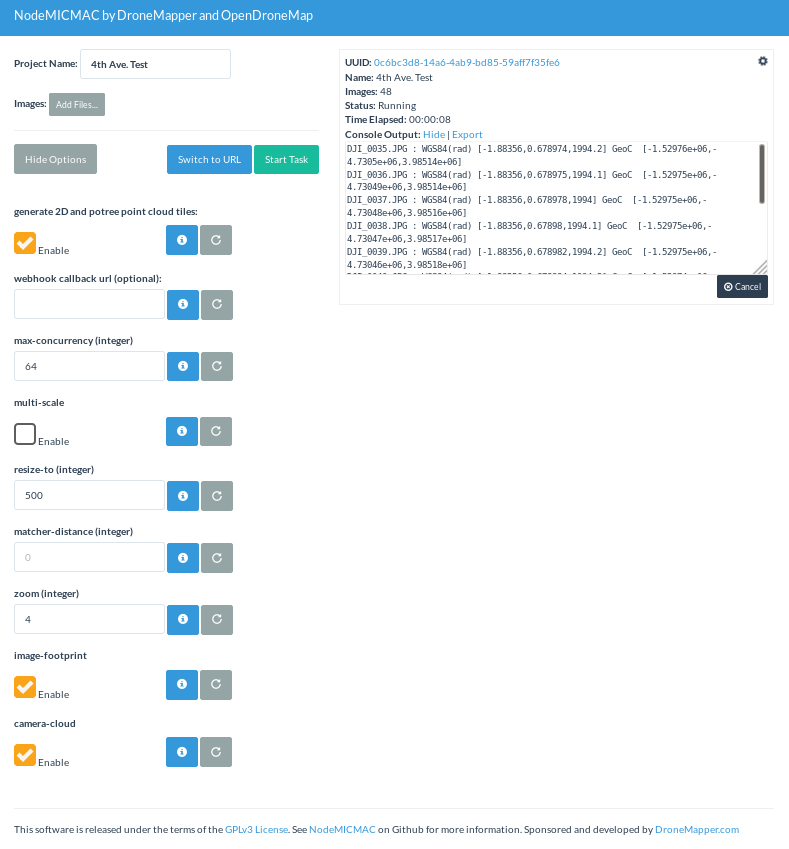
NodeMICMAC: NodeMICMAC is a Node.js App and REST API to access MicMac. It exposes an API which is used by WebODM or other projects. This project is sponsored and developed by DroneMapper. This repository was originally forked from NodeODM, which is part of the OpenDroneMap Project.


NodeMICMAC @ github

Make a pull request for small contributions. For big contributions, please open a discussion or issue first. Feel free to contact us with questions!

Thanks, DroneMapper Team

Read more…

3689739740?profile=original3689739595?profile=original3689739821?profile=original3689739873?profile=original

Nothing revolutionary, just a printed quad that can take the Sony range of mirror-less cameras. Am awaiting delivery of the Herelink unit to complete build. The rest of it - Pixhawk Cube, SimpleBGC, Tmotor 4 in 1 F55A ESC. Batteries from 8000-16000. Expecting 25 mins from 14,000 6S. The Herelink will replace so many onboard units and antennas like - RX, Telemetry radio, Video TX, HDMI converter. 

Read more…

Have you ever encountered these problems on battery-powered multi-rotors: it is very hard to get a 45 minutes flight time with 5KG payload at an altitude of 4500 meters, due to the thin air up there. Or it is almost impossible for the multicopter to fly for 1 hour in the cold winter at a minus 10-degree temperature because the battery voltage will drop dramatically in this case. YANGDA YD6-1600L gas-electric hybrid drone is designed to overcome these drone flight time limits. It is using one powerful gas-driven electricity generator which will give you continuous and stable power supply despite the high/low temperature or high altitude, will enable you to carry out long-range inspection, survey, aerial photography, search, rescue, and public safety applications.

Long flight time
When equipped with a 4L fuel tank, the YD6-1600L fuel-electric drone is able to fly 3 hours without payload.

High-performance and stable propulsion system
YD6-1600L hybrid power UAV is using T-Motor propulsion system, which is proved of high quality and stability.

Easy for transportation, quick to set up
Pluggable arms of YD6-1600L frame makes the drone is easy for transportation. The drone set up can be done in 5 minutes by a single man.

Backup battery
YD6-1600L hybrid drone provides 2 units 6S lipo batteries for 90 seconds emergency landing, just in case the gasoline-electric engine fails during the flight.

Multiple payload options
All YANGDA drone gimbal, camera and other payloads like drone megaphone can be installed on YD6-1600L hybrid UAV.

Photos

3689739694?profile=original3689739611?profile=original3689739666?profile=original3689739714?profile=original3689739573?profile=original

Read more…
3D Robotics

Flying stick bi-copter

From Hackaday:

Fixed-wing planes and helicopters are no longer the darling of the RC world. Even quadcopters and other multirotors are starting to look old hat, as the community looks to ever more outrageous designs. [rctestflight] has slimmed things down to the extreme with this coaxial bicopter build, also known as the Flying Stick (Youtube video, embedded below).

The initial design consists of two brushless outrunner motors fitted with props, rotating in opposite directions to cancel out their respective torques. Each is mounted on a gimbal, setup to provide control authority. iNav is used as a flight controller, chosen due to its versatile motor mixing settings. The craft was built to test its ability at recovery from freefall, as a follow-on from earlier attempts at building a brushless “rocket” craft.

Performance is surprisingly good for what is fundamentally two props on a stick. Initial tests didn’t quite manage a successful recovery, but the repaired single-gimbal version almost achieves the feat. Multirotors in general struggle with freefall recovery, so more research in this area is definitely worthwhile. 

Read more…
3D Robotics

3689739488?profile=originalFeatures and benefits
• Modular parts
o Easy-to-replace powertrain. No more soldering hassles.
• Fully assembled and ready-to-fly
o Avoid the headache and uncertainty of building a drone from scratch. Draco-R is fully assembled, tested, and ready to fly, right out of the box.
• Integrated Jetson TX2 (or Nano)
o Auvidea J120 carrier board
o Draco-R’s flight controller is tightly integrated with the Jetson onboard computer.
• Powerful powertrain
o Inherits the speed of the award-winning Draco racing drone, Draco-R easily reaches speeds of over 100km/h
• Smart battery
o The SMBUS-based battery provides you with detailed information without calibrating the current sensor, unlike with most drone batteries
• Payload mount bay
o Draco-R gives you a mounting plate for a wide variety of payloads
• RTK-GNSS ready
o Draco-R can be equipped with RTK-GNSS (optional)
• Computer vision ready
o Draco-R is tested with most Intel RealSense products including VIO-based indoor navigation and obstacle avoidance.
• Hot swap between desktop and field
o Keep implementing your ideas without interruption! Draco-R supports hot swap and online battery charging while you run a companion computer on your desktop

More information and purchasing details here

Read more…

A new version of Sputnik GIS presents new tools, optimized performance, usability, and new integration capabilities.

Sputnik GIS is a professional drone surveying software for engineers, surveyors, and urban planners. Visualize and analyze multidimensional spatial data with no limits on data size, create surveys and get insights from your drone data in height performance GIS solution.

Optimization and integration capabilities:
Sputnik GIS 1.4 has a new paradigm of working with geodata inside a project, in new version user may set up coordinate reference system for the whole project using EPSG base or import proper *.prj file. All geodata inside project will be transformed into a project coordinate reference system on the fly. Sputnik now supports LIDAR point clouds, with this feature LIDAR point clouds may be used in combination with orthomosaic and 3D models reconstructed from an aerial survey. A new user interface makes easier to work with basic tools and geometries during vectorization process.
 
Surveying and mapping:
For surveying purposes, we have implemented new tool for working with surfaces – «Relief editor». With this tool user may delete features from the surface, to create DTM from DEM for example, or model new features with 3D geometries, in addition, «Kriging-interpolation» tool is optimized. For operative and field mapping purposes «Image projection» tool is implemented, with this tool user may create mosaic with raw spatial reference from aerial survey photos.
 
Urban planning:
For the analysis of the urban environment, the tools daylight modeling, visibility area, and observation point are implemented. With the help of daylight modeling tool specialist may estimate the insolation conditions of territory in a given date and time. Visibility area tool along with observation point tool allows to model viewpoints and blind spots. Sputnik GIS helps to present city development projects in an intuitive environment (three-dimensional model of the city), which facilitate the process of discussion and decision-making. For creating the presentation, materials of the design solutions implemented a set of special tools: Video tour and animated track. With presentation tools, a three-dimensional model of the city easily turns into an animated scene with the ability to record video.
Try Sputnik GIS right now: https://www.geoscan.aero/Sputnik.exe
Read more…

3689739287?profile=original

2018 July, Heilongjiang China - XAG observes a rising demand for plant protection UAS in northeast part of China, with number of P series units operating in the region growing rapidly during farming season this year.

Heilongjiang Province, along with Liaoning and Jilin Province as the Northeast region in China, is one of the major market for plant protection aviations. The number of UAVs, operating area, coverage and other aspects has far exceed other regions of the country. Compared with 2017, the agricultural UAV market has developed and changed rapidly this year.

The number of agricultural UAVs in Heilongjiang Province in 2017 was very small, back then it was difficult to carry out large-scale plant protection operations covering the whole province. However,  the number of UAVs has grown significantly starting from this year’s operating season. XFIS data indicates with XAG P series plant protection UAS alone, there’s more than 1000 units operating in the region.

3689739385?profile=original

Since the beginning of the operating season in May 2018, the total operating area in Heilongjiang has exceeded 0.6 million ha. , and Heilongjiang has become the first province in China to break through such coverage in the area of UAV plant protection operations. It is estimated that the total operation area of the region will reach up to 1.6 million ha. this year, but it is far from covering the demand of 16 million ha. cultivated land in Heilongjiang.

China is entering an ageing society. In Heilongjiang Province for example, the number of people over 65 years of age is 4.558 million, and with forecast increase of 1 million in 10 years, accounting for 12 percent of the population. 

With the ageing of the rural population and the sharp reduction of the labor force, the stable plant protection market will attract more wait-and-see people to join in with the higher situation of UAS plant protection this year. 

It is expected that in 2019, the plant protection UAS market will usher in a bigger explosion, a significant increase will happen to both the number of plant protection UASs and the coverage of operation.

Read more…
Moderator

3689739368?profile=original

uAvionix, designer and manufacturer of communications, navigation, and surveillance (CNS) equipment for unmanned and manned aircraft today announced a partnership with CubePilot (ProfiCNC and Hex) designer and manufacturer of the world leading “The Cube” autopilot (Formerly known as “Pixhawk”) for unmanned aircraft systems (UAS) – to integrate ADS-B IN receive capability into its Carrier Board.

The new Carrier Board, available in July this year, integrates uAvionix’s custom ADS-B silicon for 1090MHz ADS-B reception for worldwide Detect and Avoid (DAA) functionality. CubePilot, which Proudly uses the open-source ARDUPILOT platform, previously provided plug-and-play functionality for several uAvionix ADS-B IN and OUT products, including PingRXPing2020i and Ping1090i. Support for these products is retained in the new design, allowing for 978MHz ADS-B reception or integration of ADS-B OUT functionality.

With this integration, UAS operators will be able to see nearby ADS-B OUT enabled aircraft on ARDUPILOT’s Mission Planner, allowing the remote pilot in command (RPIC) with timely notification to take the necessary actions to remain well clear.

“With this partnership, uAvionix furthers our goal of ensuring safety and common situational awareness between airspace users,” states Christian Ramsey, uAvionix President. “We believe that ADS-B IN functionality should be a requirement for every DAA system for UAS operations over people or Beyond Visual Line of Sight, and that meeting that requirement should not be cost prohibitive.”

https://www.suasnews.com/2019/04/uavionix-proficnc-and-hex-announce-ads-b-in-capability-for-the-cube-autopilot/

Read more…

YANGDA FW-250 is a reliable and affordable VTOL fixed-wing plane designed for long-range inspection, survey, aerial photography, agriculture, search and rescue and public safety applications. As a fixed-wing UAV with VTOL and hover capabilities, the FW-250 features a modular airframe that can be set up in less than 10 minutes, does not require runway or catapult to get airborne. Once in the air, the aircraft transitions to horizontal flight as a push-prop fixed-wing.

Tool-free assembly
Due to its modular airframe design, FW-250 can be set up in less than 10 minutes by a single man.

Long flight time
FW-250 airframe is using light-weight and high strength composite material, which will enable the fixed-wing plane to fly up to 2 hours with 2KG payload, at an average cruising speed of 75KM/H.

Multiple camera options
These cameras are compatible with FW-250 VTOL aircraft: Sky Eye-U30 30X zoom cameraEagle Eye-30IE-U 2-axis 30X EO/IR camera.

Specification

Wingspan: 2.5m
Fuselage: Composites 
Frame Weight: 2.68kg
Total Weight: 5.5kg(without battery)
Max Take-off Weight: 12kg
Max Payload: 2kg
Flight Time: 2 hours with 2KG payload
Max Speed: 100km/h
Stall Speed: 15m/s-16m/s
Altitude: 3000m

RTF Combo
1 x YANGDA FW-250 VTOL fixed-wing airframe
4 x T-motor MN505 KV260
4 x T-motor FLAME 60A ESC
2 x T-motor 1654 CF Propeller CW&CCW
1 x T-motor 4120 KV250
1 x T-motor 12S 60A ESC
1 x 15x8 Wooden Propeller CW
4 x DS135MG Servo
1 x Px4 Air Speedometer
1 x ASSAN UBEC-8A
1 x Power Monitor Module
1 x Pixhawk 2.1 Standard Set with Here 2 GNSS
1 x YR16S Radio Controller
1 x Assembly and Flight Test Service

Photos

3689739051?profile=original

3689739183?profile=original

3689739224?profile=original3689739138?profile=original3689739247?profile=original3689739257?profile=original

Read more…