We are very often asked about thermal camera performance to detect man-sized target (approx 1.7x0.5m) or detect small car (approx 2.5m x 2.5m). So we decided to create a short video that shows the thermal camera capability to detect different sized objects (car, person, tractor etc.) at different distances (more in video).
Make your Companion Computer more stable, not suddenly reset by fluctuating power supply in fly time, reduce noise by the devices like ESC, motor, servo…
Stable Power Module is professionally designed with power IC 5V-5A to provide stable power for Companion computer as well as peripheral devices. It also has a built-in Serial port for connecting Companion computer and flight control. All connector in Stable Power Module is Dronecode standard (JST GH and Molex Clik-Mate)
Easy Connect
Technical detail
Weight:
21gram
Dimensions:
60 x 35 x 15 mm
Power Input:
7 to 36V power input (CLIK MATE 2.00mm)
Power Out:
5V/5A for
Rasp Pi (Jump 2.54mm)
Cooling fan, Peripherals (CLIK MATE 2.00mm)
Features:
Serial port (JST-GH)
Reverse voltage protection
Resist fluctuated, noise of electric power
Green Led Indicator Power
Compatible:
Compatible with all companion computer which have Rasp Pi pinout (2x20 2.54mm)
As part of a Google Summer Of Code (GSOC). I have the privilege to Mentor a talented PhD Student of the Nanyang Technological University of Singapore, named Thien Nguyen.
Since the beginning of this project , Thien has delivered a series of Labs to serve not only as milestones for the project but also a step-by-step guideline for anyone who wishes to learn about using the power of computer vision for autonomous robot to follow. The labs include:
Lab 1: Indoor non-GPS flight using AprilTags (ROS2-based)
Lab 3: Indoor non-GPS flight using Intel T265 (ROS-based)
Lab 4: Autonomous indoor non-GPS flight using Intel T265 (ROS-based).
Lab 5: MAVLink bridge between Intel T265 and ArduPilot (non-ROS).
Lab 6: Calibration and camera orientation for vision positioning with Intel T265.
I invite you to read about this series of well detailed experimentations and instructions on how you can implement the RealSense T265 tracking camera system :
Here is a video showing autonomous indoor flight using the system in ROS-Mavros environment (this is part of Lab 4):
Lab 5 shows how to fly using a Python Scrit sending MavLink Message Vision_Position_Estimate directly to Flight Controller.
You can read the underlying principles of how to incorporate a VIO tracking camera with ArduPilot using Python and without ROS. After installing necessary packages, configuring FCU params, the vehicle can integrate the tracking data and perform precise navigation in GPS-less environment. Pose confidence level is also available for viewing directly on GCS to quickly analyse the performance of the tracking camera.
Thanks to Thien for this amazing project, experiments can now be carried on the T265 with different Flight Controllers and stacks compatible with the Vision_Position_Estimate MavLink Message.
This is pretty cool. NXP is giving away 100 of its new Dronecode/PX4-based ready-to-fly drone development platform to people entering its "help fight fires with drones" competition with Hackster.io.
"Engineers at the University of Toronto have designed a fully open sourced dual-rotor tail-sitter MAV using readily available electronics and 3D-printed parts. The Phoenix drone is based on the PX4 autopilot platform, PX4 middleware, and is equipped with a Pixracer flight computer, supporting both flight control and ArduPilot’s SITL simulation.
“Our open source package, available onGitHub, includes mechanical design documents, component lists, a carefully tuned and verified dynamics model, control software, and a full set of simulation tools — in short, everything necessary to understand, construct, test and verify a prototypical tail-sitter MAV.”
On the hardware end, the Phoenix is outfitted with a flight computer that packs an STM32F427VIT6 SoC loaded with a Cortex-M4F microprocessor (256Kb of SRAM), and a series of sensors — an Invensense ICM20608 (accel/gyro), an MPU-9250 (accel/gyro/mag), a Measurement Specialties MS5611 barometer, and a HMC5983 magnetometer (with temp compensation).
The drone’s frame was constructed out of a cast polyurethane foam core and 3D-printed plastic parts, making it extremely light. Driving the Phoenix are a pair of Gemfan 8-inch diameter 4.5-inch pitch propellers, powered by TMotor 2208–18 1100 Kv brushless DC motors and a 2200mAh Li-Po battery.
On the software side, the engineers tasked custom flight-control software based on the Pixracer autopilot platform with PX4 support, along with ESC firmware (based on BLHeli), and the MAVROS robot OS, which they use to tie in the Phoenix to a ground station for control. They also included aMATLABSimulink system and SITL Gazebo to compile and test flight code on a desktop PC. The team states that the Phoenix is a great learning and research platform, and hope educators, hobbyists, and researchers use it to create “innovative new modifications and derivatives.”
We've just launched an international competition in partnership with the Omidyar Network and would very much value your kind help in sharing this new opportunity far and wide.
As the name -- Unusual Solvers -- suggests, we are not looking for the same, usual suspects to pitch their solutions. Our hope with this competition is to connect with local, talented individuals from the Global South, and specifically those who are rarely if ever part of such competitions. This is why we need this opportunity to be communicated far and wide, i.e., well beyond our own immediate networks.
Posted by Greg Dronsky on June 17, 2019 at 11:13am
Amazon is finally starting to address some of the actual challenges with drone delivery, making us slightly less skeptical
Amazon has been working away at its Prime Air urban and suburban drone delivery for years. Many years. It’s been at least half a decade now. And for the entire time, we’ve been complaining that Amazon has been focusing on how to build drones that can physically transport objects rather than how to build drones that can safely and reliably transport objects in a manner that makes economic sense and that people actually want.
At its re:MARS conference today, Amazon showed off a brand-new version of its Prime Air drone. The design is certainly unique, featuring a hybrid tailsitter design with 6 degrees of freedom, but people have been futzing with weird drone designs for a long time, and this may or may not be a.) what Amazon has actually settled on long-term or b.) the best way of doing things, versus other techniques like Google Wing’s dangly box.
What’s much more exciting is that Amazon seems to now be addressing the issue of safety, and has added a comprehensive suite of on-board sensing and computing that will help the drone deal with many of the complex obstacles that it’s likely to encounter while doing its job.
We should point out right away that Amazon’s pleasant piano music means that you cannot hear what this drone sounds like in flight, and noise is turning out to be one of the biggest problems with urban and suburban delivery drones, as Google Wing has discovered in Australia. Amazon seems to be taking the same “oh people will just get used to it” approach as Google is, and for better or worse that’s probably what’s going to end up happening. Sigh.
The really cool bit about today’s announcement is the addition of sense and avoid to Amazon’s drones, which Jeff Wilke, Amazon’s chief executive for worldwide consumer, detailed in a blog post:
Our drones need to be able to identify static and moving objects coming from any direction. We employ diverse sensors and advanced algorithms, such as multi-view stereo vision, to detect static objects like a chimney. To detect moving objects, like a paraglider or helicopter, we use proprietary computer-vision and machine learning algorithms.
For the drone to descend for delivery, we need a small area around the delivery location that is clear of people, animals, or obstacles. We determine this using explainable stereo vision in parallel with sophisticated AI algorithms trained to detect people and animals from above.
A customer’s yard may have clotheslines, telephone wires, or electrical wires. Wire detection is one of the hardest challenges for low-altitude flights. Through the use of computer-vision techniques we’ve invented, our drones can recognize and avoid wires as they descend into, and ascend out of, a customer’s yard.
This is a good start, although I would push back a little bit on the assertion that Wilke ends with that “our drones are safe.” This technology certainly has the potential to make Amazon’s drones much safer than they were before, but my guess is that statements like “our drones can recognize and avoid wires” would probably be more accurately written as “our drones have the ability to recognize and avoid wires most of the time when conditions are favorable.”
Photo: Jordan Stead/AmazonJeff Wilke, Amazon’s chief executive for worldwide consumer, unveils the new Prime Air drone at the company’s re:MARS conference.
Whether the sensors are effective at low sun angles, when there’s lots of glare after it rains, or in particularly challenging situations like trying to detect black wires against black asphalt from above is unclear. It’s awesome that Amazon is tackling all of this stuff head-on, but it’s important to be very careful not to take these “we’ve solved it” statements at face value until Amazon has shown exactly what their drone can do, which as far as we know they have not.
And even with all this progress, I can’t help but come back to the fundamental question of whether this kind of drone delivery is actually worth it. I love robots, and I’m having a very hard time thinking of this as anything more than a novelty, especially considering the growth of both autonomous vehicles and sidewalk robots (which Amazon is also working on). Amazon brings up the environmental impact of delivery as another argument in favor of drones, suggesting that “an electric drone, charged using sustainable means, traveling to drop off a package is a vast improvement over a car on the road.” Likely true, as long as the car is delivering just one package—I’m not sure how the numbers work out if you’re comparing drones to a loaded delivery van, though. And again, noise pollution needs to be considered, too.
Delivery drones are the right answer, I think, in some cases. Medical supply delivery is one. Rural delivery is another. It’s less clear whether suburban delivery really fills a long-term need, or whether companies like Amazon and Google are mostly just doing it because they can. But either way, it’s great to see Amazon acknowledging these hard problems, and we’re looking forward to seeing some of their technologies, like obstacle avoidance, in action, which Amazon says could happen within months.
ARX-R V2 frame is the fastest 5"/6" class quadcopter currently on the market. It is a beautiful piece of engineering that has been developed by Ryan athttps://quadstardrones.com/
Well guys it's been a while! I own a Chevy Volt now and I just cant wait to fiddle with it! LOL so I started a Group on Facebook for the project and I'll be adding a website and forum at teamprometheus.org for the project.
After starting the group one of the new member's Matt Davis Pointed this out.
So I think it's only natural Ardupilot can do the same.
But I didn't create the group just to use autodrive. There is so much more to do than that! Like getting control of the infotainment system and adding an onboard computer to the touch screen built into the Volt. Gaining control of the modules and allowing battery modfications and Fast charging and feature controls. So much more is possiable!
The willdest project I have in mind is using 2 Volt drive systems in my class C RV that has 7000w of solar and having the volt as a TOAD and have it's system help provide propulsion and braking for the entire train! LOL yeah that's just an idea. But so much really is possiable with these new EV vehicals and it should be furtile ground for future programmers of vehical designs and for the future of the industry.
December 2018, GUANGZHOU China – XAG’s Research and Development Center in Guangzhou officially released the "XAG Agricultural IoT System”. The XAG Agricultural IoT System is composed of a series of farmland IoT devices and application software. This release of the XIoT kit includes: XAG® FarmCam 1, XAG® FarmMonitor 2, and the WeChat-based "Electronic Guardian" Mini Programs, as an important part of the intelligent agro-ecology of the science and technology at XAG.
At XAAC 2017, the company unveiled its first-generation farmland monitoring station, Field Monitor 1, which was affectionately known by farmers as the "electronic guardian". As an agricultural monitoring and recording device which is completely powered by solar energy and connected by the mobile communication network, XAG FM1 opens up a new possibility of agricultural production.
From the dragon fruit base in Guangdong to the ant forest in Alxa, from the winery in Australia to the black soil land in Northeast China, FM1 has been widely used in various occasions.
After one year of application, through further research, development and iteration, XAG introduces two new products, XAG® FarmCam 1 and XAG® FarmMonitor 2.
Crop growth is mainly affected by atmospheric environment and soil environment. By accurately recording the soil and meteorological data of crop growth in the production process, the growth status and yield of crops can be predicted.
Through in-depth research in agronomy and other related fields, the XAG Agricultural IoT System uses the FC1 and the FM2 to translate the natural codes into field images, data messages, and field prescriptions.
In agricultural production, every day will produce a lot of data, light, air temperature and humidity, soil fertility, crop growth and so on. XAG’s R&D team believes that data collection and management, analysis of crop types, categories and growth cycles can help farmers to precisely apply chemicals, as a way to reduce the waste of pesticides and fertilizers, improve crop yields and reduce agricultural management costs.
The goal of applying XAG Agriculture IoT System is to let farmers see and understand the information transmitted by nature, make scientific agricultural decision-making.
Meanwhile, trace from the source of food production is a key process of food safety for the consumer market. Letting consumers see the process of agricultural production can help reduce misunderstandings caused by lack of information. It is of great significance to ensure food safety and reshape the trust relationship between consumers and agricultural production.
For some time now, VTOL drones have entered the field of aerial mapping. These Vertical Takeoff and Landing drones offer the flexibility and ease of use of a multirotor combined with the range and stability of a fixed wing UAV.
At The Fieldwork Company we have been using both fixed wing and multirotor drones for aerial surveys for many years, and always like to stay at the forefront of technology. So we decided to create a comparison of some VTOL mapping models to guide us in buying the right model for us. Hopefully this will help others choose what fits their needs.
3 commercially available VTOL mapping systems are the Vertical Technologies DeltaQuad, Wingtra WingtraOne and AtmosUAV Marlyn. They all boast impressive websites and present a lot of figures that are not always easy to understand or put into context.
The key focus of our comparison was price (<50k), performance and options. We have omitted several properties that were either identical in all models, or not relevant to the core task. For example, they all offer PPK, a rugged flight case and automated survey generation.
All data below is based on published specifications, information requested from the manufacturer and in some cases derived or based on common sense. So here goes comparing VTOL apples with apples.
* The maximum wind conditions listed are those in which the vehicle can still operate safely, these are generally not conditions in which a mapping mission is feasible. Wingtra has released a video showing how their vehicle operated in high wind conditions that clearly show conditions unsuitable for mapping: https://youtu.be/aTCK1GOAB-U
** The prices indicated are based on quotations from the manufacturer. To give a fair comparison we have requested exactly the same options on every model: The Sony RX1R-II, a PPK system with base station, a ground control station and a rugged flight case. Not all quotations included all components and the deviations are listed.
Based on our comparison we chose the DeltaQuad as it offers the most range per flight and the most moderate price. So far we have been pleased with the results, their specifications seem to match reality and the system flies very stable.
Aeromao from Canada is pleased to announce that the Aeromappers line of commercial grade drones have been added to the list of compliant UAV systems of Transport Canada. This distinction allows Canadian organizations using Aeromapper drones to apply for Compliant Operator status.
A total of four drone system models the company produces have been added to the list of compliant UAV systems for advanced operations, according to Transport Canada UAS Standard:
Aeromapper Talon
Aeromapper 300
(New) Quad Mapper VTOL: fixed wing system with VTOL capabilities
(New) Nano Mapper: sub 1Kg. fixed wing drone suited for agriculture and high affordability.
The Quad Mapper VTOL and Nano Mapper are two new UAV system models that will soon be made available to the public.
Two more variants of the Aeromapper Talon are currently awaiting confirmation from Transport Canada to be added to the list of compliant drones: Aeromapper Talon Amphibious and Aeromapper Talon LITE (a 3hr endurance version also suitable for BVLOS operations).
“Aeromao’s UAV solutions officially meet Transport Canada’s standards of safety and efficiency. We are truly excited to continue assisting Canadian and foreign customers with their drone programs, not only by ensuring that our systems continue meeting the latest regulatory policy changes but also by diversifying our line of commercial drone systems that fit all customer requirements and budgets” says Mauricio Ortiz, CEO of Aeromao.
The Aeromappers have demonstrated over the years a history of safe operation in some of the harshest environmental conditions both in Canada and other countries around the world.
About Aeromao Inc. Is the Canadian leading UAV solutions provider and manufacturer, developer of the Aeromapper series of turnkey unmanned aerial vehicles for mapping, surveying, precision agriculture, remote sensing, inspection and surveillance. With exports to more than 48 countries since 2012, Aeromao Inc. offers a line of products that adapt very quickly to market demands and to unique client’s applications, where no other UAV manufacturer goes. The Aeromappers have been used by corporations, research organizations, universities and government agencies around the globe for a great variety of applications. Aeromao not only manufactures and sells the Aeromappers and related sub-systems, but also extends its services to:
Payload & drone customizations
Flight training and support
Flight operational support
Assistance with difficult missions, difficult terrain
Local drone experts, entrepreneurs and engineers from 23 countries in Africa, Asia, Latin America and Oceania have signed this Charter on Equal Opportunity & Inclusion regarding the use of drones for social good such as humanitarian aid, public health, sustainable development and nature conservation.
The Charter calls on both regulators and international organizations to enable not hinder equal opportunity and inclusion. Give local experts the opportunity to lead and participate meaningfully. Trust that local knowledge and local ownership are key for sustainable impact. This is particularly important in the context of disaster management. First responders to disasters by definition are -- and always have been -- local actors.
We would be grateful for your help in disseminating this Charter widely should you agree with these principles. Thank you kindly.
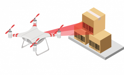
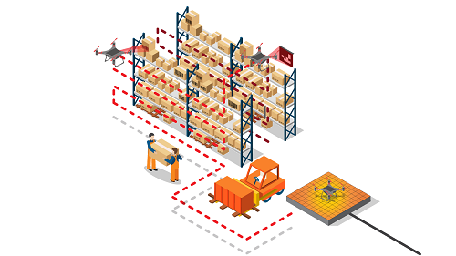
We had recently released a white paper highlighting the role of autonomous drones in the digital transformation of warehouses. Driven by safety, cost and revenue benefits, warehouses across the world are adopting technologies such as Internet-of-Things, Artificial Intelligence, and Unmanned Aerial Vehicles. Drones are playing a central role in the intelligent automation of warehouse operations — given their ability to fly & hover autonomously, avoid obstacles, navigate indoors without GPS, land precisely on docking stations, operate in fleets and be remotely managed.
The business benefits from drones are significant and immediate given low capital expenditure & infrastructure investments, access to reliable, off-the-shelf drone hardware, and SaaS offerings forwarehouse automation. API-based integration makes it easy for existing warehouse management systems to onboard autonomous drone missions and data into enterprise workflows. Capabilities such as remote drone operations over 4G/5G connections, real-time high-quality video recording, and unified dashboards can extend the use of drones to warehouse use-cases such as perimeter security, rooftop inspections, detecting leaks & corrosion, external surveillance, etc.
Pioneering warehouse stakeholders have successfully concluded proof-of-concept projects on multiple use-cases eg. cycle counting, real-time inventory identification and drone barcode scanning — these involved executives from R&D, innovation, digital transformation, IT, operations, and continuous improvement. They have now matured to pilot programs that involve repeatable missions of drone fleets — thus realizing meaningful value for a wider set of business cases — and intend to soon expand to large-scale production deployments of drone fleets, across their global operations.
While the business case for the adoption of drones for warehouse inventory search, counting and audit are strongly compelling, two key factors determine the success and RoI of drone investments. The first is the ability of drones to reliably, safely and repeatedly navigate indoors in an environment with no GPS, continuous human activity, high-value inventory and moving obstacles such as fork-lifts. The second is how accurately a fleet of autonomous drones can locate and identify specific aisles, racks, pallets, slots and items — despite markers (eg. barcodes) that are covered by dust, wrapped in plastic, damaged during transit, visible only at angles, or even missing. Other factors to be considered include continuous autonomous flights, ambient conditions, rate of inventory turnover, ease of integration with WMS, frequency of cycle counts, size and layout of each warehouse, time to set up and charge the drones, aisle widths, length of shutdowns, and many more.
FlytBase is pleased to share our learnings from customer engagements to help drive broader adoption of drones by warehouses, driven by intelligent software, commodity hardware, and seamless integration. With an approach that combines multi-sensor data, computer vision, deep learning, modular architecture, hardware-agnostic OS layer, and multiple fail-safe mechanisms, software providers can accelerate the Warehouse 4.0 trend towards true and full automation.
The‘Drone Automation For Warehouse 4.0’white paper can be downloaded, for free, fromhttp://bit.ly/flytws-paper.
IBM‘sDeveloper Drone Drop 2019contest is officially underway. Now through June 16 the company will give away 1,500 drones to developers who enter. Why is IBM giving away free drones? It hopes you’ll use them to deliver AI-powered solutions to the problems caused by natural disasters.
The contest officially started last week, but there’s plenty of time to sign up. You don’t have to be an expert or have any code built already to enter – the winners will be selected at random, not by judges. Winners will receive more than just a robot,according to IBM:
The DJI Tello drone is more than just a cool prize. We’ll give you code patterns to unlock its potential, and introduce you to new skills around visual recognition, AI and machine learning.
The giveaway comes courtesy of IBM‘s Code and Response, a new initiative this year from the company that aims to empower developers with the resources and support to implement original technology-based solutions to humanity’s open problems.Inspiring developers who, otherwise, might not have access to IBM‘s resources and mentors is a strategy that’s already paying off for the company.
TNWspoke to IBM Code and Response CTO Daniel Krook to ask why IBM was giving away drones for the second year in a row. He told us:
Who doesn’t like free drones? It’s about inspiring people … it’s not just altruism on IBM‘s part, we believe this technology can help humanity and IBM is a part of humanity.
One of last year’s hackathon winners, Pedro Cruz, developed his drone-based disaster relief tech after experiencing the devastation of Puerto Rico by hurricanes Irma and Maria.
The recently released Version 3.2 of my GCS FlightZoomer offers an automatic approach system, that is similar to the ILS for manned aviation. For plane it was working since last year but since copters can't just slip down the glideslope and then touch down with a lot of forward speed, the implemented procedure had to be changed as follows for copter: ❶ At first, Copters will stay in GUIDED mode and will descend on the glideslope towards the runway. ❷ The moment, when an altitude of 7m above ground will be reached, the descend will stop and the copter will continue in level flight until the begin of the runway is reached. ❸ At that point, forward speed will be cut to zero, and FlightZoomer will put the flight controller automatically in LAND mode. ❹ The ArduCopter LAND mode will then simply perform a straight down descend.
As you can see in the examples in the video (towards the end), the whole procedure works nicely and supports rather fast descends.
For what purpose could ILS approaches for copters be useful?
As any number of runways and glideslopes can be defined upfront in the FlightZoomer navigation database, the airspace can be structured to support flexible flight operations in changing conditions (different for plane vs copter, have runways for different wind directions).
The final descend can start in a controlled manner at a rather high altitude. There is no need to for a long descend in LAND mode.
Solution picks up terms and procedures of manned aviation.
More details can be found in the FlightZoomer User documentation:
Recently YANGDA team tested the 2-axis 30X EO/IR dual-sensor gimbal Eagle Eye-30IE-U on a fixed-wing VTOL drone, you can see the gimbal performance from the demo video above. A nice camera to conduct surveillance, search and rescue missions.
Some details of the gimbal:
Compact and lightweight The compact 1.2kg compact system is ideal for integration into UAV, fix wing and VTOL.
High-quality video sensor Eagle Eye-30IE-U is using SONY FCB-EV7520 camera block, features anti-fog, video enhancement and some other advanced features.
Continuous 360-degree rotation The gimbal has continuous 360-degree rotation under standard HD-SDI output, which will enable the gimbal to track targets freely without any angle limit.
Easy for integration Eagle Eye-30IE-U comes with an amazing advantage that the gimbal can not only be controlled via PWM signal, but also serial command. Also, gimbal status(like Yaw/Pitch/Roll angle, zoom position etc) can be obtained by sending serial command to the gimbal via its serial port, which is really useful for precise gimbal control and system integration.
If you have any question about the camera, please feel free to let us know, thanks!
Happy Weekend! We hope your week starts out well. We did a short Flight WITHOUT RC Transmitter and Datalink, only use 4G LTE to control our Fixed Wing. And the result are very good, feels like we were a bird
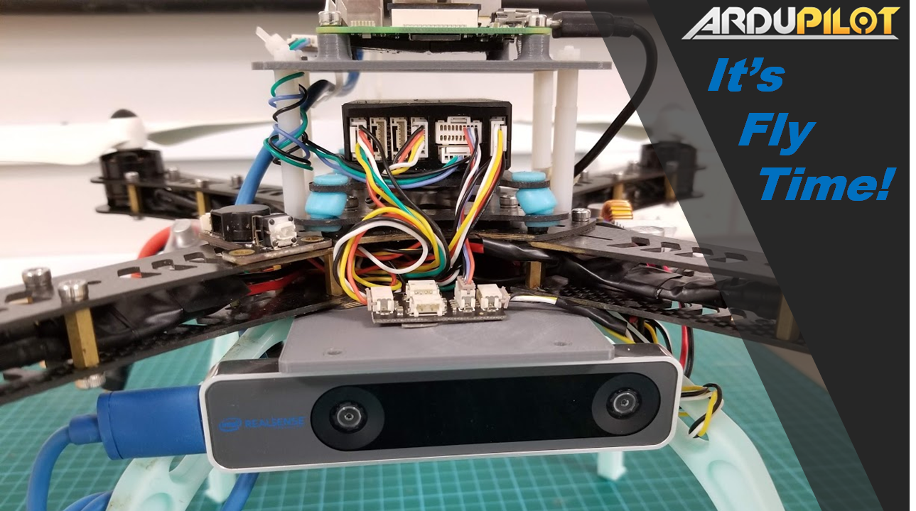

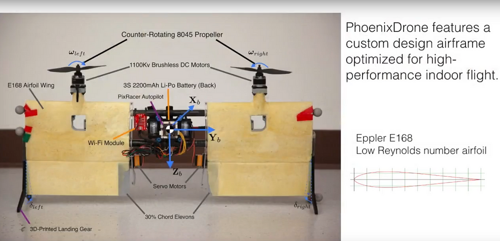
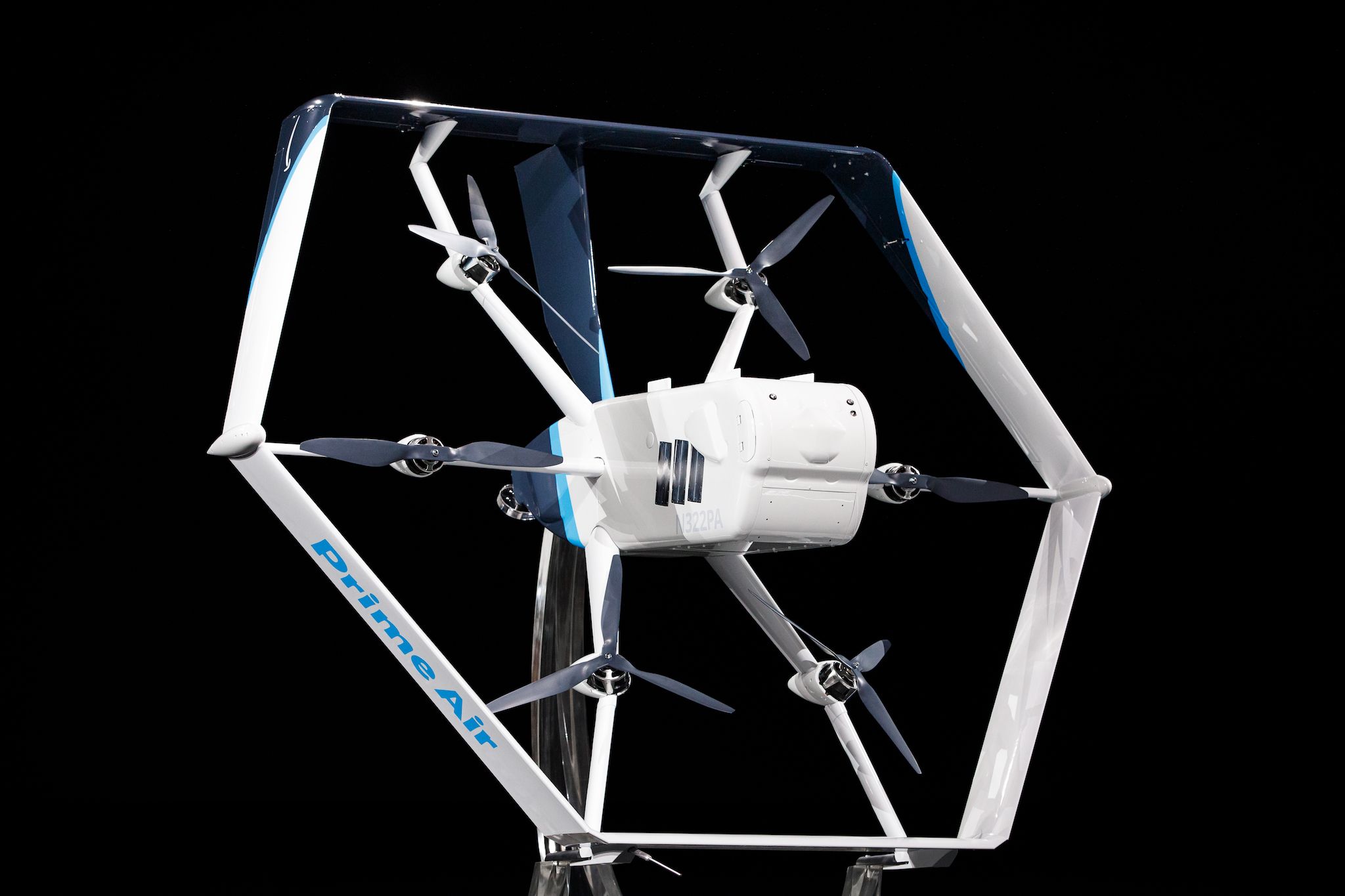
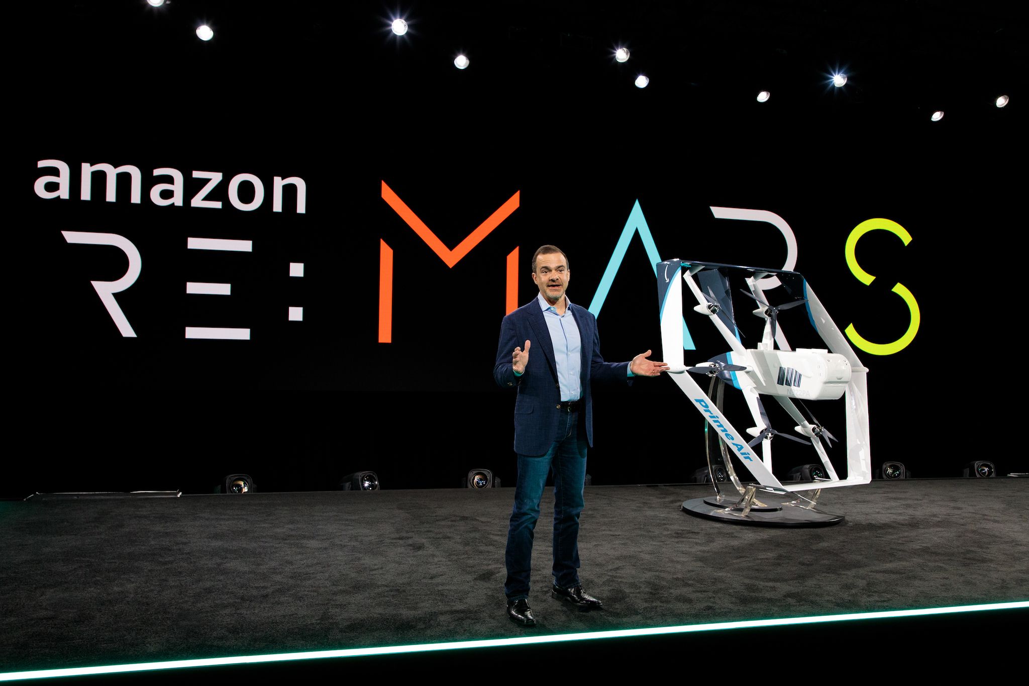 Photo: Jordan Stead/AmazonJeff Wilke, Amazon’s chief executive for worldwide consumer, unveils the new Prime Air drone at the company’s re:MARS conference.