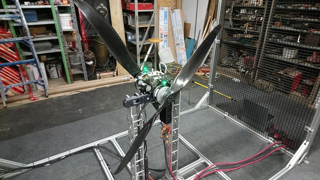
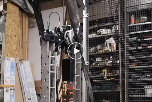
A hybrid drone attachment which can pick up, transport, and manipulate objects as well as adaptive land on uneven terrain.
Key advantages Manipulation Mode:
- Delta-robot like 3DOF manipulation - Precise and fast manipulation - Low moving masses, less disturbance of rotorcraft flight behavior
Compact Flight Mode (retracted landing gear): - Low Energy consumption due to deactivated actuators - Masses closest to rotorcraft for best maneuverability - Best Aerodynamic Characteristics - Smallest geometrical food-print
Adaptive Landing Mode: - Adaption to uneven surface - Stabile tripod geometry - Low energy consumption due to deactivated actuators (when landing position is reached) - Dampening of legs can be used to absorb impact energy
Applications:
- Inspection - Delivery - Agriculture - Construction - Mining - Maintenance - Search and Rescue - Military...
Please reach out if you have interest or potential application ideas for this system. Thank you!
It's customary and traditional that we celebrate the addition of every 1,000 new members here and share the traffic stats. We've now passed 90,000 members!
A few observations on this milestone:
It took 12 years to get to 90k members. It's a marathon, not a sprint
Although this is a zero-person operation (it runs itself, with a few volunteers moderating), it's one of the largest robotics communities in the world.
Growth has slowed as the drones world has become more Off The Shelf and less Do It Yourself, but we still get a quarter-million pageviews a month. That's not bad!
One of the good things about having been so prominent in drones for more than a decade is that our search-engine authority is great. That's why 80% of our visits are from new users -- they're coming via search.
Once we hit 100k I'm probably going to have to find a better way to celebrate ;-)
We're pleased to announce the upcoming launch of our newest online course, which several colleagues at the Center for Disease Control (CDC) and World Health Organization (WHO) have already taken.
The course draws on the collective lessons learned and best practices in the use of cargo drones in public health during the past 5 years, including the most recent insights and real-world deployments. As such, the course combines WeRobotics' first-hand experience in operational cargo drone projects with the first-hand experience of our partners and the expertise of other leaders in the cargo drone space. Full details here.
We'd be very grateful if you could kindly forward this new opportunity to your relevant contacts and networks. We also hope you'll be able to join us for this course and share your own expertise and experience.
As you probably know, the increasing temperatures as created a generation of wild fires that are destroying the forests of California, Chile, Spain, Asia, and other different dry areas of the world.
With this problem in mind we have created this hexacopter to perform Automatic Aerial Restorations. We used digital fabrication techniques, like laser cutting for the frame and 3D printing for the seed dispenser, and we released everything with a Creative Commons license to allow conservation organizations to replicate it.
This is the electronics that we used:
This configuration allow us to fly 41 minutes without payload, but since the sowing operation takes 10 minutes to empty the seeds, a smaller batteries are recommended. The plywood frame is very cheap to fabricate and only weights 1.8 Kg.
Specifiations:
Total weight without payload: 9,7Kg.
Flying time without payload: 41min.
Maximum payload: 8kg of seeds.
Autonomy: Can sow in autopilot one hectare in 10 minutes, around 5 seeds by square meter, with a speed of 5 m/s.
Production cost: 1961,75 US$
We made step by step instructions, shematics, and videos for the Epilog Instructable contest that you can found here:
Hope you like the project, since is open source, you can contribute too! We want to organize the community around in the Wikifactory page of the project.
Airspeed sensors have been a major concern for both manned, and unmanned aviation alike. Yet almost every fixed wing or VTOL vehicle is dependent on it. So what is wrong with these sensors and why are they used?
How an airspeed sensor should work
A standard airspeed sensors consists of a pitot tube, a temperature sensor and 2 pressure sensors. The pitot tube has 2 ports (holes), one at the tip (like an injection needle) which is called the dynamic port, and one at the side which is called the static port. Each of these ports are connected to a pressure sensor. When the tube is pointing forward on a moving vehicle, it can measure the difference between the pressure from dynamic and static port. When factoring in the temperature it can estimate the current speed through air.
So whats the problem?
Over the years many problems have been identified with the use of airspeed sensors in both manned and unmanned vehicles. There is not one major problem so here is a list in random order;
For both manned and unmanned aviation
Icing: The same ice you see forming on the wings of an airplane can accumulate inside the tubes. When this happens the reading get unreliable or inconsistent at best.
Water: It might sound scary, but a few drops of rain inside the tube can cause the sensor to fail. The pitot tube holes are therefor made as small as possible.
Sand & dirt: Due to the small size of the holes sand or dirt can get lodged inside the tube rendering it useless.
Calibration: An airspeed sensors requires calibration before every flight. This is needed to account for the difference in readings the 2 pressure sensors will give. No 2 sensors will read exactly the same. The calibration is a snapshot that can be different from one moment to the next.
Drift: As the sensors are in operation they tend to drift due to temperature changes, how they drift is not always the same so it is hard to compensate for this.
Angle of attack: As you might imagine the system only works correctly if the sensor is pointing directly into the wind, but the pitch angle of any aircraft, especially unmanned, can change based on speed, air pressure, temperature or drag.
Specifically for unmanned vehicles
It’s fragile: The sensor needs to measure undisturbed air to work, and therefor needs to stick out in front of the UAV. The pitot tube is hollow and fragile and can easily break during transport or landing.
It needs special calibration: Not everyone is a UAV specialist, and properly calibrating an airspeed sensor takes a specialist. The board computer cannot tell if the calibration was done correctly, it just needs to assume it was.
Temperature drift: A UAV heats up as it flies. This means there is a drift in temperature that does not correlate to the air temperature. The board computer will try to compensate for a temperature that is not the actual air temperature.
Cross wind: Where manned aircraft usually have multiple airspeed sensors, UAVs normally have only one. If it flies in a cross wind there will be extra pressure measured on the static port (on the side).
The effect of incorrect airspeed readings
If the airspeed data is missing most vehicles UAVs will not takeoff or enter some failsafe mode. But usually the data is not missing, it is simply incorrect. With incorrect readings it will either fly too fast and therefor very inefficient, or it will fly too slow and in many cases crash.
Another serious side effect of bad airspeed readings is landing. Fixed wing UAVs are generally loaded to their maximum capacity. That means they need to fly their absolute minimum speed to land without damage. If they land too fast they start tumbling and usually break their wings or worse. VTOL fixed wing UAVs do not have this problem, but still suffer from inefficient or dangerous flight behavior when the readings are incorrect.
Eliminating the danger
During the research & development of theDeltaQuad VTOL UAVit quickly became clear that the airspeed sensor was a major concern. We therefor embarked on achieving the impossible: completely eliminate the danger.
Having members on thePX4 core development teamcan be a big advantage when pioneering in unmanned aviation. Using this advantage we managed to completely eliminate the need for an airspeed sensor by using a variety of other sensors to estimate our airspeed accurately and consistently.
Achieving accurate and reliable estimation was not easy, and required very specific tuning and testing, but the end result turned out better then we hoped. Using our estimated readings we not only eliminated all the issues in relation to airspeed sensors, we had also increased the efficiency of our vehicle by 20%
So if you are considering the purchase of a fixed wing or VTOL UAV, and you see a probe sticking out in front that look suspiciously like an airspeed sensor, make sure you think twice.
Posted by yangdaonline on March 28, 2019 at 1:13am
YD6-1600L hexacopter frame is a multifunctional heavy-lift flight platform. Its one-time forming carbon fiber technology reduces weight while still keep the stiffness, which makes it stronger and lighter for long flight time.
Stable and reliable YD6-1600L arm connector is using special compound material: industrial plastic with glass fiber. This compound material features high strength and flexibility, which can stand high-frequency vibration created by the motors in the air. Furthermore, with a glass fiber canopy, the GPS signal will not be blocked.
Easy for setup and maintenance Frame arm of YD6-1600L is detachable, which will enable you to finish the drone setup in 5 minutes. Furthermore, if the arm is broken during a flight crash, you will just need to replace it with a new one, which will greatly save your maintenance cost and time.
Long flying time Equipped with the 29inch propeller, KV85 U8 Lite motor, 2 units 6S 32000mah HV lipo battery, the YD6-1600L frame is able to fly 61 minutes with 2KG payload, 47 minutes with 5KG payload.
Good for drone customization YD6-1600L comes with big size center frame, which is able to accommodate more devices. So it becomes an ideal flight platform for your drone customization.
Posted by jerry zhang on March 21, 2019 at 12:30am
Nowadays, agricultural drone sprayer has been used in many places to spray pesticides. In the past, the high-tech drones have become more and more grounded and entered the agricultural field. Some people say that the agricultural drone sprayer will replace the traditional sprayer for plant protection. Homework, reliable? Then come and analyze it for everyone today.
Traditional sprayer
When you mention a traditional knapsack hand sprayer, you might think of a picture: a person carrying a hand sprayer, pulling the rocker into the dosing box and repeating the action. it is really tough! This type of sprayer was developed in the 1930s. The effective utilization rate of pesticides is uneven and the spraying is uneven, resulting in a large amount of liquid medicine being wasted.
40%-60% of the liquid directly flows into the soil, and 5%-30% of the liquid is diffused into the air in a very misty form to float. Therefore, it also causes serious pollution to the environment; the most important point is that the traditional sprayer is low in safety because a large part of the liquid medicine floats in the air during the spraying process, and if the person touches or inhales for a long time, The health of the applicator causes great harm!
High efficiency of spraying pesticides: Agricultural drone sprayer rotor produces downward airflow, turning the action leaves, the liquid is more easily infiltrated, can reduce the dosage of pesticides by more than 20%, and achieve the best spraying effect. The ideal flying height is 1-2. Meter, flying speed is less than 18 m / s. While greatly improving the efficiency of the work, it also achieves the insecticidal effect more effectively. For example: Taizy carries 10 kg of Agricultural drone sprayer, the daily workload can reach 20,000-30,000 square meters per day, which is 20-30 times of manual work, and the efficiency is greatly improved.
More uniform spray: Taizy Agricultural drone sprayer can now achieve no electricity, no medicine, anti-shipping, breakpoints, and automatic route planning. However, manpower dispensing requires constant replacement of the drug, and walking back and forth may cause local spray unevenness or heavy spray leakage.
Lower cost: Agricultural drone sprayer sprays pesticides are generally leased, according to the size of your planting area, compared to the labor costs are much lower.
Xiao Bian feels that China's Agricultural drone sprayer technology is now relatively mature, and the efficiency is high, the cost is low, and it will be widely popularized in the future.
In the end, no matter what the way, it is for our farmers to harvest, I hope that our agriculture can be better and better, our farmers' pockets are getting more and more drums!
Please pay attention to our website for more details.
Vertical Technologies launches the DeltaQuad Pro #INSPECT
To meet the growing demand for dedicated solutions in a wide range of drone enabled inspection tasks, Vertical Technologies have expanded their autonomous DeltaQuad Pro VTOL range with the DeltaQuad Pro #INSPECT.
The DeltaQuad Pro #INSPECT exceeds all the specifications required for actionable inspection flights and is available with a downward facing camera sensor that records video with embedded GPS coordinates. The vehicle is designed to accommodate the Flir Duo Pro R Dual Thermal & RGB sensor, or the MapIR Survey3 RGB sensor.
The DeltaQuad Pro #INSPECT can cover up to 150KM in a single flight, has been equipped for fully autonomous flight along a planned path and is easy to control. It can be used for a wide range of inspection tasks including;
As a member of the DeltaQuad family the DeltaQuad Pro #INSPECT provides all the features that make the DeltaQuad series among the most versatile and easy to use commercial VTOL UAVs on the market.
Vertical Technologies is a Netherlands based manufacturer of commercial grade VTOL drones for Surveillance, Transport, Mapping and Inspection. For more information please visit www.deltaquad.com.
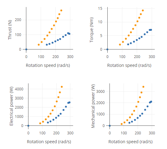
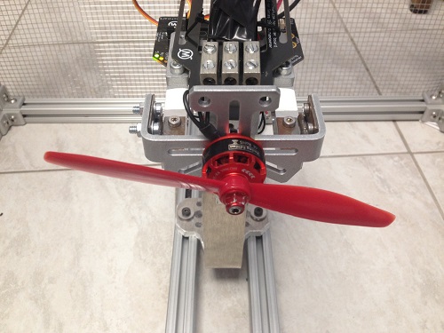
I will discuss the challenges of designingthis database. Searching for the right propulsion components for a UAV is tough. There is not much data available, and what is available from suppliers is not standardized or reliable. Even with the right tools, you still have to buy and test many components before finding the right motor and propeller. My team and I have extensive experience with dynamometers, so we have a good understanding of the issues, but we still had some serious challenges when designing a database.
Dynamometer tests produce a lot of data. This data is very sensitive to the test conditions. The first obvious challenge in a user-contributed database is figuring out how to create a standardized test environment. There is, unfortunately, no international standard on propulsion test for small UAVs. I can say from personal experience with hundreds of businesses and universities that everyone does it differently. It is also not possible to record the entire test environment, so we cannot only use software checks. In the end, we came up with multiple solutions to minimize the variance between the test. First, we developed a strict test procedure and environment with a checklist. Second, all the tests are done with a script and uploaded automatically to minimize the risk of operator error. Third, the test script has multiple checks to test for data consistency. Finally, all the test data is available in the database and we encourage people to upload pictures and comments, so other users can verify the data accuracy and comment on it. We intend to implement a voting system so more people can help catch incorrect data.
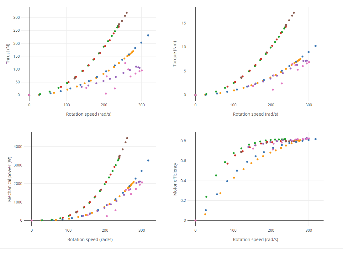
Another challenge is regarding sorting and categorizing the data. We developed a component-test model where each component can be associated with multiple tests, and multiple tests can be associated with multiple components. For example, thiscoaxial testhas two motors and two propellers. If you click any of the components, you can see all the tests that were done with this component. This test-component model is important for data analysis. You can already see the data plotted on each component and test page, but it is possible to do more. We are working on an analysis module that will allow you to extract the fundamental motor and propeller parameters (Kv, i_0, C_t, C_p, etc…) from multiple tests. Those parameters will also be searchable.
The data in the database will always be freely accessible if contributors choose to make their data public. We are planning a model similar to GitHub where users pay only for private components hosting and analysis. We currently only support RCbenchmark test tools, but we are definitely open to supporting other tools if other people develop motor and propeller dynamometers.
Test of the Xoar Coaxial 47 and 40 inch prop
Next on our list of feature is display unit selection, advanced analysis and search, and an option to share embedded graphs on forums and websites. I invite you to browsethe databaseand submit feedback! The database is still in alpha, so some features are missing, but it is already useable for searching, categorizing and data analysis.
The Aeromapper Talon Amphibious is the only truly affordable fixed wing UAV system that can be used for inspection and mapping in marine environments. The UAV system delivers high resolution georeferenced imagery as well as video feed from up to 30 kms from the operators. After completing its mission the UAV later returns and safely lands on the water, adequately serving maritime Beyond Visual Line of Sight (BVLOS) operations.
But how to ensure proper waterproofing for repeated landings on the water?
By design, the UAV can stay indefinitely afloat on the water, and even sustain full immersion without any damage or water intrusion, even in salt water.
To reach this level of dependability the engineers at Aeromao spent more than a year of lab work and field testing, experimenting with different materials, solutions & compounds, techniques and components to ensure a very high level of reliability. The base model is the well-known Aeromapper Talon, which has been the flagship for the company since 2014. The UAV is designed to fully survive and float even if fully filled with water, because internal components have been carefully waterproofed individually.
Some of the industries that can benefit from this technology are:
Coastal & river mapping/surveying
Fisheries
Inspection of infrastructure or wildlife
Ecology & conservation
Surveillance
Marine management
Flying on remote atolls
As of this writing, a couple of Amphibious Talon units have been successfully operating during a 4 week expedition by a worldwide renowned British conservation institution. The location is on an undisclosed remote atoll in Belize, as part of a series of very important efforts for conservation & ecology and enforcement and control of illegal fishing activities over protected areas.
The type of terrain offers little or no land to operate from, therefore only truly amphibious drones are usable. The drones have been successfully launched from both beaches or small boats and then landed autonomously landed on the water after each flight is completed.
Image credit: Three Wise Monkeys & Zoological Society of London
The expedition team required a drone capable of be launched from a boat, record high resolution video and stills, send live video feed to the Ground Station at very long ranges, be able to fly in 40km/h winds, return and land on water, and repeat several times daily and for several weeks. The Aeromapper Talon demonstrated to be the only suitable solution for the challenge. More information on the expedition to come soon.
More information about the Aeromapper Talon Amphibious can be found here.
Image credit: Three Wise Monkeys & Zoological Society of London
Image credit: Three Wise Monkeys & Zoological Society of London
About Aeromao
Is the Canadian leading UAV manufacturer, developer of the Aeromapper series of turnkey unmanned aerial vehicles for mapping, surveying, precision agriculture, remote sensing, inspection and surveillance.
With exports to more than 45 countries since 2012, Aeromao Inc. offers a line of products that adapt very quickly to market demands and to unique client’s applications, where no other UAV manufacturer goes. The Aeromappers have been used by corporations, research organizations, universities and government agencies around the globe for a great variety of applications.
Aeromao not only manufactures and sells the Aeromappers and related sub-systems, but also extends its services to:
Payload & drone customizations
Flight training and support
Flight operational support
Assistance with difficult missions, difficult terrain
I'm happy to share wit you last updates about our cubesat project. The great news is that we adopted ChibiOS operating system and start to develop a flight attitude estimation and control for Cubesat based on ardupilot projects. The other challenge are about the telemetry control system and payload managment.
If some guys in the network are working already on cubesat project or would like to join us in these great project are welcome :)
The main iusse respect of drone development is that is not so simple simulate the flight of cubesat on the earth so we are working also on HIL system for try to simulate what happen in the space . The idea is to add to VR Brain Space the hardware and software compatible with ardupilot project for control a Cubesat in the space .
Hope that you like our projects and join in these great new challenge.
How do you take down a drone? This is the question being asked at DroneClash 2019 next Saturday 16th March.
At this spectacular competition - dubbed by the BBC as “a sort of Robot Wars in 3D” - the latest counter-drone measures will be tested to the limit.DroneClash’s latest videogives some clues as to the range and scale of challenges that await the nine international teams entering DroneClash this coming weekend.
The video depicts a series of increasingly extreme counter-drone measures from net guns to to ball cannons, each struggling to hit the target. Then the camera reveals a new idea: a Tesla Coil. Will the drones fly or fry? With two metre-long sparks and millions of volts, it doesn’t look good for the drones. But it doesn’t stop there! An army of engineers marches on set, representing the drone researchers and First Person View (FPV) pilots who will be battling it out in the DroneClash arena next week.
The spate of drone related incidents in recent months, such as that at Gatwick London Airport, have shown just how disruptive and potentially dangerous drones can be. The need for effective, affordable and scalable counter-drone technology is paramount, which is why the Delft University of Technology is staging DroneClash for the second year in a row. With sponsorship and support from the Dutch Ministry of Defence and the Dutch Police, the event is intended to spark innovations in this important field.
During the course of this spectacular competition, drones will attempt to navigate counter-drone measures like the Tesla Coil in the so-calledHallway of Doom, Death and Destruction,before doing battle with each other. The aim is to take down as many drones as possible, and knock out the rival Queen drone. Teams are competing for a prize pot of €50,000.
Between battles, the audience will be challenged to take down TinyWhoops (small consumer drones) by means of hacking or even by testing out their own counter-drone measures (think: tennis rackets and telescopic wands, rather than fire and fury).
DroneClash also provides a platform for businesses working in the rapidly developing field of counter-drone technology, with the ClashExpo exhibition taking place in parallel.
As an industry, we had high hopes for the use of drones in anti-poaching efforts. But in hot climates everything looks hot to airborne thermal cameras and fleet logistics are crippling. Dogs work much better. Here's a sobering report from the field:
I spent 2 years flying anti-poaching drones in the Kruger National Park and other reserves, clocking up hundreds of hours and Robert is right, everything is a trade-off unfortunately. And that’s only the start, there are so many difficulties in the actual operation, very few people have even the slightest idea of what it entails.
The design and building is really the easy part. So if that is hard then one is going to have a hell of a struggle on-site in the bush in 39°C heat (and that’s at 11pm at night!) not counting all the other challenges.
From my experience I believe, that even with the best intentions and best technology, drones will never have more than a negligible effect on poaching. To put it in context, the Canine teams in the KNP’s best haul was 18 poachers apprehended in one week. Our drone team saw less than 8 poachers in TWO years of night flying, with not one apprehension. So if the drone is not CATCHING an average of 2-5 poachers a WEEK then it’s of no use. And note that poachers get around deterrents easily.
KUA payload drop system is mainly designed for multi-rotors to carry out long-range drop mission in remote locations which are hard to reach for the human being. It consists of 2 parts: one carbon fiber drop box, and Sky Eye-I 10X zoom camera which is used for searching target location to drop items.
Heavy payload supported The drop box of KUA is able to hold max 10KG payload.
Long range If KUA payload release system is mounted on long flight time multicopter, then it is able to carry out long-range drop missions. Compatible YANGDA frame: YD4-1000S, YD6-1000S, YD6-1600S.
One key to release We use one 2-level gear to release the payload on the RC controller.
Quick to setup You will only need 5 minutes to do the setup.
After the premiere of the X-TANKCPOPTER in 2015, the product was illegally copied by Chinese manufacturer WL Toys also by Brookstone and flooded the market :(. Additionally, the idea was quickly and poorly explored; features terrible performance, quality and aesthetics and it cannot be compared to the original X-TANKCOPTER. I do not only look for funding drone production but help in fighting against unfair business practices of big corporations. That steal many inventors dreams; in this case, they even infringe the granted global patent.
After a few years of financial struggle, I am back with the new version of the X-TANKCOPTER.
X-TANKCOPTER is the world’s first flying tank, which performs well both on the ground and in the air. The product was designed from scratch, features patented propulsion system, allowing for an efficient combination of both locomotion systems – driving and flight. Next generation of the X-TANKCOPTER will also be able to swim.
Although it looks like a tank, the X-TANKCOPTER can quickly ride, drift, nimbly overcome obstacles encountered and explore hard-to-reach spaces. In very demanding terrain, it can fly up into the air, record high-resolution video and take a photo. It is equipped with an HD live camera and has most of the features of commercial drones ( auto takeoff and landing, waypoints (custom route), Atti mode, smartphone app etc.) from leading manufacturers. X-TANKCOPTER weighs only 125g and therefore does not require a special license to operate.
Exclusively for DIYdrones and drone lovers, I am sharing the link to secret perk where you can get the X-TANKCOPTER for only 89 USD!
Not only that, we hope to build full-size All-Terrain Flying Car capable of human transportation. Currently, it is the only concept in the world, that has all-terrain driving capabilities (due to large diameter wheels and enormous clearance) combined with vertical take-off and landing. Here is the 3D model of such a vehicle, after the first round of investment we hope to begin R&D work this year.
Posted by Chetu Inc on February 27, 2019 at 7:00am
Where is the agricultural drone industry headed?
Agriculture is the second largest commercial market for drones after construction, and contributes $32 billion worth of services to farmers, according to PricewaterhouseCoopers, and Global Market Insights predicts the agricultural drone market size will pass $1 billion, and 200,000 units, by 2024. Plummeting costs of drone, camera and sensor technology and more sophisticated software are contributing greatly to the adoption level.
Can drone software help with food security?
By making farms more efficient and boosting production, drones, and the software that runs on them, can adapt to the world's rising population and combat world food shortages. By applying fertilizer with precision, drones reduce greenhouses gases in the atmosphere, fighting climate change. And by monitoring for pests and diseases, drone software improves the quality of our crops and the quality of our food.
Posted by Ryan LaDue on February 22, 2019 at 2:30pm
Construction
While drone contributions to surveying and monitoring progress at construction sites may seem like an incremental update, it’s actually going to be revolutionary. An enormous amount of material waste and landfill bulk comes from construction. If managers are able to save money, reduce waste and improve their strategy through better monitoring with UAVs, you can bet they will take off fast.
Disaster response
When four consecutive storms worked their way through the Caribbean Sea, Gulf of Mexico and Atlantic ocean in 2017 infrastructure took a massive hit. Maser Consulting’sUAS emergency response teamused their UAVs to quickly assess infrastructure damage and conduct utility inspections. In times of natural disaster, restoring cell towers and power utilities is a critical priority. UAVs can be deployed well before conditions become safe for humans to conduct inspections as well as cover ground more quickly.
This one may seem a bit far-fetched, but ski resorts have enormous swathes of land that they must monitor diligently for ecological reasons as well as to ensure that infrastructure is in tip-top shape. You don’t want your ski lifts going backwards, after all.
One could even imagine the presence of a thermal sensor-equipped UAV as a swanky safety feature in avalanche-prone areas. Here’s to hoping it has a tiny barrel of whisky strapped on it like those rescue dogs from the cartoons.
I'm proud to share Leonid Plekhanov, our CEO interview at CES'2019:
We showcased our GET Air product at CES'2019 (first time ever!). Please take a look at photo-video report on our website — really good piece of information where you can see our system in industrial design: http://getcorp.com/get-ces2019-gallery/
We also were able to get FCC experimental license in December (which is a big step forward), right before CES, so we demonstrated system in action.
About GET Global Energy Transmission (GET, US corporation) uniquely enables battery-powered drones to fly forever by safely and quickly recharging while still in flight. Drones simply hover for a short time (few minutes!) in one of our large charging area, which can be installed kilometers apart along flight routes, and inside. GET offers GET Air solution which includes Ground Station for wireless power transmission and commercial grade drones equipped with built-in GET technologies, including Wireless Power Receiving system and Rapid Battery Charging pack.
Posted by jerry zhang on February 20, 2019 at 6:00pm
Citrus as a high-efficiency economic crop, various social capitals have poured in and invested, so the Agricultural drone sprayer is not to be outdone, but also flooded in. As a cash crop that requires fine management, citrus has a high incidence of pests and diseases, so a year, citrus growers need to invest in a small number of pesticides. The traditional method of spraying drugs is to use the steam/diesel engine as the power, press the potion to the atomizing nozzle, and manually apply the citrus. In recent years, the Agricultural drone sprayer has been hot and squeezed in to get a piece of cake.
First, there is no way in front of high technology.
Everyone knows that the Agricultural drone sprayer is a high-tech thing. It is not something that ordinary farmers know how to operate. It requires professionals to operate. To fight drugs for citrus, you need to ask another professional to operate, which undoubtedly increases the cost. Of course, there are also some plant protection companies that provide a full range of services, such as providing drugs and helping to fight drugs, but these drugs are not necessarily what growers like, and the price may not be acceptable to them.
Second, the planting scale limit
Most of the citrus industry is distributed in the southern region, while the terrain in the southern region is dominated by mountainous hills. The farming mode of one acre and three points is very obvious. Most citrus growers are responsible for growing their own responsibilities, and the area of responsibility is limited. The Agricultural drone sprayer simply does not work. This is why large agricultural machinery is difficult to promote in the South. And how many growers can really scale, such as a thousand and a few acres?
Third, the tree structure determines the land of useless dance
Citrus, as a fruit tree, is different from a simple fruit such as dragon fruit. Its tree structure is complex, its branches are leafy, and its roots, neck and neck are filled with pests and diseases. The agricultural drone sprayer, most of which is applied from the upper part of the citrus tree, is often used to take care of the leaves outside the tree. It is difficult to completely and completely fight the drugs. In particular, some stubborn pests of citrus, such as citrus red spiders, are mostly lurking in the back of the leaves. At this time, it is difficult to treat them with the agricultural drone sprayer.
These are the main reasons why the agricu drone sprayer is difficult to promote on citrus. Of course, plant protection drones also have its advantages, such as separation of human and machine, can avoid frequent exposure to pesticides on the human body; efficiency is much higher than manual application. Our company's agricultural drone sprayer has professional and technical personnel training, if interested Please pay attention to our website: https://www.agriculture-machine.com/agricultural-drone-sprayer-in-china/