All Posts (11086)

Sort by
3D Robotics

"Letting Drones Reach Their Potential"

3689502395?profile=originalSomehow I missed this excellent op-ed by Ryan Calo when it came out in December:

Letting Drones Reach their Potential

Why the potential uses of drones for good are endless and should be protected

Ryan Calo | December 12, 2012

I have three concerns regarding the domestic use of drones.  The first is that drones will facilitate massive surveillance by the government.  The second is that private parties will use drones to harass one another.  The third is that, precisely because of their readily imagined capacity for privacy mischief, the transformative potential of drones will never be realized.

This third concern – the concern for the drones themselves – may be the most pressing.  The prospect of military-grade drones on the home front is certainly chilling, but the present reality is that police departments cannot afford cutting-edge technology.  The drones owned by, for instance, the City of Seattle, where I live, can only stay up in the air for a short time.  It turns out to be hard to oppress in 10-minute increments (law firm billing notwithstanding).  This is not to deny that officers could put today’s drones to questionable use, borrow drones from the federal government, or upgrade their technology over time.  But for now, opportunities for constitutionally offensive conduct are relatively limited.

Similarly, many may recoil at the prospect of flying cameras in the hands of teenagers or paparazzi.  No bathroom window or backyard would be safe.  Those already uncomfortable with Google’s Street View technology might not welcome a less vertically challenged update.  Yet, the Federal Aviation Administration (FAA) – the American agency that Congress recently charged with expanding drone use in the United States – is not supposed to relax restrictions on private use until at least the fall of 2015.  This gives us a few years of breathing room.

In contrast, the danger that citizen backlash will ground drones is immediate.  As I’ve argued elsewhere, drones constitute an atypically visceral and salient example of surveillance technology.  People in the West are nervous about robots in general.  We find the specific act of drone surveillance – which many associate with the theatre of war (see “KILL”) – all too easy to imagine.  As such, drones generate intense opposition, to the point that I’ve gone on record saying that drones may help resuscitate long-dead concepts such as the reasonable expectation of privacy in public.

But think of the drones.  The potential uses of drones for good are endless (see “AID”).  The police can use drones to find the missing, improve tactical responses through better situational awareness, respond to disasters, or photograph unusual or difficult-to-access crimes scenes.  Parents are using drones to confirm their kids make it to the bus; teachers to teach physics; artists to provoke and reveal; activists to police the police; farmers to monitor and tend crops; environmentalists to catch polluters; and architectural photographers to explore new angles.  Likely, too, drones could be used for something you’ve never heard of: Perhaps the most wonderful development has been the emergence of the drone as a platform, which leaves the possibilities for applications in the millions of hands of software developers and end users. 

One might be tempted to simply tell opponents of drones to calm down.  That would be a mistake.  First, they absolutely have a point: This technology is headed in a direction that could seriously undermine civil liberties if left unchecked.  And second, no one takes well to being dismissed out of hand.  Rather, we should give in to their demands – demands, it should be noted, that are by and large very reasonable.  The FAA should acquiesce to requests from the Electronic Privacy Information Center, the chambers of Representatives Ed Markey and Joe Barton, and others, to condition issuance of licences to operate drones on responsible privacy practices.  Demonstrated privacy violations could then result in revoking the licences.  Domestic and federal law enforcement should be more transparent about existing and anticipated programs.  And police departments should commit to securing a warrant before using drones for many investigative purposes.  These, and perhaps other, reasonable conditions are a small price to pay to avoid curtailing a transformative technology of our time.

MORE FROM THIS SERIES


Read more…

NVida Shield: Controller + Groundstation Combination

Image of NVIDIA Project SHIELD

802.11n 2x2 MIMO game-speed Wi-Fi

I have been thinking quite a while now about what would make the ultimate UAV flight controller.  Reading through a CES highlight story I saw the NVidia Sheild project that basically combines an Android Jellybean touchscreen tablet with a game controller.  Of course this device is "vaporware" and is designed for gaming, but it doesn't take much of a stretch of imagination to run the Mission Planner for Android software currently under development, plugging a USB telemetry link into the port on the back, and flying/driving the UAV of choice.  Closing the lid it appears to be quite portable.  It will be interesting to see what the price will be, whether the display will be readable outdoors, and when will it be available.

See more at the web page http://shield.nvidia.com

With the advent of cheap cellphone processors I'm just surprised that the RC Transmitter manufacturers haven't made a transmitter that would be compatible with running a ground station software.  The mating of a cheap tlablet technology with RC transmitter seems like a good idea.

Read more…
Moderator

03ttDrones-articleLarge.jpg?width=300

Interesting legislative activity in the Lone Star State:

A drone, no bigger than a toy airplane, hovered north of the Texas Capitol, floating over the heads of lawmakers who were momentarily distracted from their morning meetings. Several of them gathered beneath it, faces tilted skyward, marveling over a pair of goggles that allowed them to watch live video of the craft’s panoramic bird’s-eye view.

But when the conversation turned to the reason for the demonstration, the tone shifted. Representative Lance Gooden, Republican of Terrell, said he was sponsoring legislation to prevent this futuristic technology — increasingly used by everyone from aviation hobbyists to law enforcement authorities — from capturing “indiscriminate surveillance.”

http://www.nytimes.com/2013/02/03/us/lawmakers-aim-to-limit-drones-and-safeguard-privacy.html?_r=0

http://radio.woai.com/cc-common/mainheadlines3.html?feed=119078&article=10784277

Of particular interest to our community:

“It will be a greater burden on the hobbyists, but I think that’s O.K.,” Mr. Gooden said. “If you’re asking me to choose between my right to privacy and a hobbyist’s right to take pictures from the sky, my privacy comes first.”

and a counterpoint:

“If I’m using it to continuously monitor somebody, I think we could make a law that would forbid such a thing,” Dr. Humphreys said. “But if I’m up there doing some other benign research and happen to capture your picture inadvertently, I don’t think ought to be outlawed.”

And as an administrative note, Chris has created a forum for talking about government drone regulations.

http://diydrones.com/forum/categories/regulation/listForCategory

Read more…
Moderator

3689502333?profile=original

Gene Robinson's work with RP Search Services has been covered here before, but there's a nice news story with write-up here.  Gene emphasizes the positive use of "unmanned aircraft" (as he prefers to call them), and how he hopes that flight permission will be easier to come by.

http://www.myfoxaustin.com/story/21079431/drones-saving-lives-thanks-to-central-texas-non-profit

Read more…
Moderator

3689502316?profile=original


In the last months on the market appear a lot of low cost micro quad , they are very nice toys i like a lot play with it . But the main problem is that the standard electronic is not hackable and i cannot use my radio for control the quad. So i decide to evaluate if was possible interface a quad toy frame with my VRBRAIN.

  • The main tets that i doing was the payload and discover that was possible to going in air with a payload of 100 gr. VRBrain in Naked configuration is only 21 gr
  • The other problem was how i can manage the motors ? So i doing a bit of retro eng and discover the electronic need to my vrbrain for control the dc motors. I don't use esc for interface the motors of quad 
  • After solve the electronic problem i start to check the patch to firmware and found how can change the pwm parameter for control the dc motors.
  • Other problem was the battery , normally the quad toys use a 1s battery but the standard input voltage is 5volt. So i check the schematics of vrbrain and found a 3volt input , put on the 1s battery a small 3.3volt stabilizer and put the output on the gps output 3.3v .
  • After last patch i thought that i'm ready for first fly , but last things  was the radio ... fortunately my Jeti receiver work also at 3.3volt  so it work , i have only a signal on my radio about low level voltage ... :(


3689502240?profile=original


The final result was this : I'm happy to present VR Pico Drones , basically it use standard arducopter32 2.9 on my VRBRAIN and support all standard functionality available in arducopter , stable , acro , loiter , rtl and auto navigation . So this is smallest Arducopter drone available on the planet :) This is only first prototype the wheight is 110 gr. My idea is to doing some optimization on board and have a 85 gr drone capable of 10 minutes of funny fly.


3689502296?profile=original


After some days of hard work this is my first fly test . I'm very happy of this first results :) The main target of this development is to use VRBRAIN for learning to fly during winter days in indoor. I play a lot with simulator but fly with a real copter is better. (sorry for audio , is in italian , the next will be in english :)


Original blog post:

http://www.virtualrobotix.com/profiles/blogs/is-possible-to-control-a-quad-toy-motors-by-vrbrain-first-test-of

Read more…
3D Robotics

Having fun with FollowMe

On a super windy day at the Berkeley Marina, we demoed the ArduCopter FollowMe function (which is built in to the Mission Planner). That's me walking around with a laptop (with a $27 USB GPS dongle), and the copter follows me around like a pet robot bird. Then at the end I tell it to land itself, which it does. 

Note that there's no RC control at all. This is all autonomous flight, with mission command issued with a point-and-click interface on a laptop. And in some serious wind, too!

Read more…
3D Robotics

Using drones to track elephants

3689502148?profile=originalFrom the scientific journal PLOS One:

The use of a UAS (Unmanned Aircraft System) was tested to survey large mammals in the Nazinga Game Ranch in the south of Burkina Faso. The Gatewing ×100™ equipped with a Ricoh GR III camera was used to test animal reaction as the UAS passed, and visibility on the images. No reaction was recorded as the UAS passed at a height of 100 m. Observations, made on a set of more than 7000 images, revealed that only elephants (Loxodonta africana) were easily visible while medium and small sized mammals were not. The easy observation of elephants allows experts to enumerate them on images acquired at a height of 100 m. We, therefore, implemented an aerial strip sample count along transects used for the annual wildlife foot count. A total of 34 elephants were recorded on 4 transects, each overflown twice. The elephant density was estimated at 2.47 elephants/km2 with a coefficient of variation (CV%) of 36.10%. The main drawback of our UAS was its low autonomy (45 min). Increased endurance of small UAS is required to replace manned aircraft survey of large areas (about 1000 km of transect per day vs 40 km for our UAS). The monitoring strategy should be adapted according to the sampling plan. Also, the UAS is as expensive as a second-hand light aircraft. However the logistic and flight implementation are easier, the running costs are lower and its use is safer. Technological evolution will make civil UAS more efficient, allowing them to compete with light aircraft for aerial wildlife surveys.

Read more here. 

3689502222?profile=original

(hat tip to Paul Kedrosky)

Read more…
3D Robotics

Kickstarter project for a "Smart-Pod" UAV pod

I hadn't noticed this on Kickstarter before, and it appears nobody else did, either -- with just 60 hours to go they've raised less than $1,000 towards an $180,000 goal. (Maybe they should have posted on it here!).  But it's an interesting idea -- just a UAV "pod" with the autopilot and camera, that you could add to any aircraft. It uses APM and a GoPro. 

Perhaps one of the reasons it didn't get many backers was the pricing: $1,500 for what appears to be less than $500 worth of parts (APM + 3DR radios + GoPro). 

Here's the Kickstarter listing:

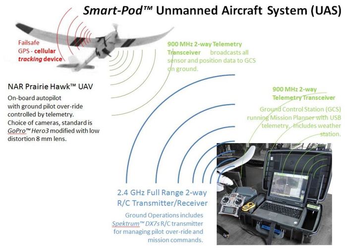
Smart-Pod™ is the core of a work-horse miniature Unmanned Aerial Vehicle (UAV) system.  It elegantly combines a custom-fit mission pod (autopilot, avionics, instruments, cameras, etc.) with a ruggedized R/C aircraft making the UAV more affordable, easier to fly, safer to operate, and more practical to support.  Coupled with a formalized UAV Pilot Training Program it represents a 'smart' way to enter the UAV field. 

(note - the above video shows our North American Robotics' 'Prairie Hawk™' Smart-Pod-enabled UAV on its 85th mission, all with no damage, regardless of landings on asphalt, dirt roads, tilled farm fields, harvested corn fields, and both short and long prairie grasses.  None posed any particular concern to the aircraft landing.) 

* If the idea of operating a UAV has appealed to you - then you will welcome our practical approach and unique products.

* If you have been concerned that learning to operate a UAV is difficult - know that we designed our UAVs specifically to be well-behaved enough for the novice, but capable enough for the advanced UAV operator.  We planned for someone who has never flown an R/C aircraft, nor gathered any aerial photography, as well as operators who need extensibility and flexibility.  We integrated compehensive Ground School with an accurate UAV flight simulator and series of real world training missions to introduce the pilot to the flight characteristics of our UAVs, and to develop their skills. This approach works.  If you're considering an entry in to UAVs - this will be and ideal start.  If you are already confident that you know what you need, this will perform dependably season after season. 

* If you have been worried about the dangers involved in UAVs -we make safety the watchword in operating a UAV/UAS.  Our Smart-Pod's "soft" materials and light weight minimize its potential to cause damage, and its special design makes pod-enabled UAVs much easier to fly and land safely than a typical R/C aircraft.

* If you have been discouraged by the start-up costs associated with the few non-toy UAVs that are available - you will see the wisdom we used to keep start-up, operating, and maintenace costs low and manageable. 

* If you want a Sci-Fi "drone" that flies itself and does all its own thinking - be prepared, you are pretty much what the FAA is working toprevent.   UAV operation needs to be done with forethought, and with consideration of both public safety and individual privacy.  Our line of UAVs is capable of nearly complete automated flight from launch to recovery, but the FAA discourages this.  Our strategy is to blend human pilot management with the automated flight.  We designed our approach to provide pitch and roll stabilization at all times making human control of the UAV smooth and unintimidating, with instant access to pre-programmed flight patterns to make complex missions easy to execute.  Our system provides the UAV pilot with immediate over-ride at all times.  This promotes the safest and most responsible of UAV operations. 

What is a UAV/UAS? 

An Unmanned Aerial Vehicle (UAV) is an aircraft, often a fixed-wing airplane, which can operate under its own control or under the control of a remote human pilot.  A miniature UAV (MAV) is much smaller than a conventional airplane, and can be deployed close to where it is needed; often hand-launched and recovered.  It can bring aloft cameras and other specialized sensors to gather aerial imagery, special infrared (IR) imagery, or atmospheric weather data.  An Unmanned Aircraft System (UAS) includes the UAV and a Ground Control Station (GCS) of some form, along with a telemetry communication channel between the pilot, the UAV, and the GCS. 


Who needs miniature UAVs and why?

A birds-eye view has always been valuable for inspecting property, managing resources, advertising and sharing a large-scale events (like outdoor celebrations or sports), and supporting scientific studies of a large or inaccessible area.  Historically, this was accomplished by a hiring a private pilot and airplane, as well as a photographic crew, and securing a special permit to fly where the desired images could be gathered.  This has beenextremely expensive, and severely limited what applications could afford it. 

With a robust miniature UAV, a wide range of applications can be explored with comparatively affordable costs.  North American Robotics (NAR) has been developing UAVs with special cameras and sensors for scientific environmental research projects, precision agriculture and improved farm production, real estate property inspection, municipal site management, and emergency response search support.  Our goal is to make these rugged UAVs available as practical tools – the kind users can depend upon to perform, and afford to actually operate. 

A different approach than other miniature UAVs

Many reputable groups and organizations are working to provide UAVs to the industries wanting to experiment with them, but the products available represent either wildly expensive ultra-high-end defense department type UASs or park-flyer near-toys, leaving the practical, “work-horse” of UAVs only to the do-it-yourself-ers.  If UAVs, especially miniature UAVs, are to get into the hands of regular people interested in developing new applications and new industry, then a product line needs to be provided that is affordable, rugged, tailor-able, safe, and most importantly – supportable. 

To be rugged, a UAV needs to protect the autopilot avionics, instruments, and sensors - making certain they can operate effectively and that they are secure throughout the mission, from transport, to deployment and launch, through to landing and recovery. 

To be supportable the UAV needs to be serviceable and ready any time the weather permits safe operations".  This is very difficult if a UAV is so unique there is only one vendor to support it, and only one place from which to get spare and replacement parts.  That means stepping back away from designing yet another unique special-purpose limited-availability aircraft andinadvertently becoming the very bottle neck of parts and support that hold back application development. 

What has been missing is a capable and robust manner of bringing popular airframes and the autopilot electronics together to make a “pick-up truck” UAV, a FORD F-150* of the miniature UAV industry.  At North American Robotics we have done just that by following a proven approach that has been employed by the U.S. Air Force, NASA, and our own DOE R&D for decades - an air-borne mission pod. 

(*FORD F-150 is a registered trademark of FORD MOTOR COMPANY.  Its use here is intended as a compliment to their product line, but does not imply endorsement or support from FORD for this project)

In the mission pod approach, all of the costly and vulnerable avionics, sensors, flight control instrumentation, and telemetry electronics are carried in an aerodynamic, ruggedized, crash-survivable pod slung beneath the aircraft’s hull or fuselage.  Furthermore, the pod is designed to be the landing gear of the UAV.  The airframe is left virtually unchanged, while the mission pod mounting is designed to not interfere with the aircraft center of gravity (CG) or any other flying characteristics.  The demonstration aircraft chosen have been capable and popular R/C aircraft, with a wealth of replacement parts and options readily available.  The example instruments (cameras and sensors) include popular series sport cameras with optional mission-tailored lenses and weatherproof impact-resistant polycarbonate cases.   

We call our approach the "Smart-Pod" Modular UAV, because it is the "smarts" of the UAV.   It is also a smart approach to building a practical UAV. 

The early Smart-Pods looked like this - a solid block of high-impact EVA foam with cavities machined in to exactly fit the autopilot and other avionics that get housed inside.   

The Smart-Pod is attached to the strongest areas of the host aircraft to create the rugged UAV.   It is shaped to be aerodynamic, and to serve as an effective landing sled to protect the instruments and the aircraft. 

The final cost of our turn-key Smart-Pod UAV is a fraction of the $15K-$20K cost of comparable mini-UAVs on the commercial market today. 

We've already constructed six (6) prototypes of the full 2-meter wingspanPrairie Hawk and Prairie Hawk Pro Smart-Pod UAVs, using three (3) different commercial R/C electric powered gliders.  We flight tested them in over 100 sorties (launch/fly mission/recovery) and developed a method to strengthen and ruggedize individual components.  In our UAV prototypes the mission pod configuration both improved the flight stability of the aircraft as a sensing/camera platform, and dramatically increased the UAV's ability to land without injury in unimproved field conditions.  It made all the test aircraft significantly easier to fly in both autopilot and in manual modes. 

Smart-Pod simple integration to aircraftSmart-Pod simple integration to aircraft
Smart-Pod in operating positionSmart-Pod in operating position


Video of Smart-Pod UAV

We have made the Smart-Pod UAV part of a complete organization of service, training, and support for individuals and groups deploying and operating miniature UAVs for academic, agricultural, industrial, municipal, and commercial applications.  (See video above and more on YouTube.com. http://youtu.be/lPNOSuqMYTQ

http://youtu.be/K6eAPm3VMxY

http://youtu.be/NEtDgU3K7-Q

http://youtu.be/QoDq8EnVIB4

http://youtu.be/GHg-cgXxI8c

http://youtu.be/1LPW7b9hTcg

)

Smart-Pod design approach

We have introduced miniature UAVs into our research involving atmospheric emissions monitoring, aerial pipeline inspection, and ground vegetation damage analysis.  For our applications we've operated from all types of terrain – plowed farm fields, unimproved roadways, military tank training grounds, rural prairies, and hard-packed deserts.  None of our field sites included a nicely mowed thick carpet of soft grass in a city park.  Because of this, we had two primary design criteria: 

·         the UAV needed to deliver the desired electronics and payload over the region of interest long enough to gather the data needed, and

·         the UAV needed to be easy to launch and rugged enough to land on any terrain, and also easy to repair if and when some damage occurred. 

“Safety” was a major concern, both to the aircraft instruments and to the people and property on the ground below where the UAV would be flown.  These practical criteria led us to the adoption of existing, popularExpanded Polyolefin (EPO) and Expanded Polypropylene (EPP) R/C airframes and the use of light and durable Ethylene-Vinyl Acetate (EVA) foam for the mission instrument pod.  These two materials were substantially unaffected by any weather conditions, retained their shape and strength throughout a wide range of ambient temperatures, remained easy to machine and work with, and would cause minimal damage during a crash. 

Each component of the commercial airframes was “ruggedized” to increase its strength and resistance to abrasion expected during belly landings at unimproved fields.  Each of these modifications allowed the component and the airframe to bear more load weight and flight stress and endure more punishment – all vital to a practical work-horse UAV.  It was not however “required” for UAV flight and operations under normal condition and the aircraft can be flown with virtually un-modified commercial parts to prevent being grounded during an important mission.  It simply performs better and safer with the ruggedized components. 

We selected a motor and ESC that had braking capability, coupled with a folding plastic propeller that would minimize any injury danger. 

We enveloped our Li-Po batteries with a light-weight fire retardant material to protect the airframe and the surrounding ground covering and property from fire in the [unlikely] event of a hard crash. 

Smart-Pod advantages

By separating the autopilot electronics and camera/sensor instruments from the hull/fuselage, and enclosing them in a container specifically designed to protect them, then the largest expense in fielding an UAV was also made the most safe and most durable. 

By making the pod easy to add to any suitable aircraft available the plane actually becomes expendable, and even in the event of a complete catastrophic crash, could be replaced with a trip to the local well-supplied hobby store putting the mission back on track in a matter of hours. 

The pod design itself can be tailored to fit and deploy a wide range of commercial cameras and experimental instruments – contact NAR and discuss this important advantage. 

Replacements for any vulnerable parts can be carried along, but are often repairable in the field with supplies available from local hardware stores. 

NAR supports and promotes the open-source ArduPilot Mega (APM) autopilot and Mission Planner Ground Control Station (GCS), which together allow visual graphical planning of complex flight missions directly on a photographic map.  NAR modifies both the autopilot to tailor it to the airframe, and the Mission Planner to make it easier to use. 
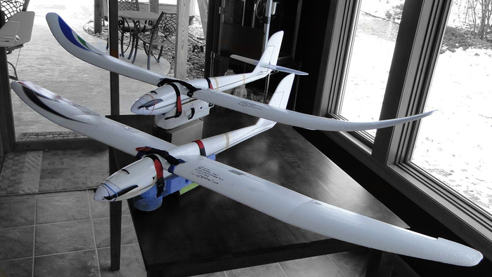
NAR Prairie Hawk and Prairie Hawk Pro turn-key UAVsNAR Prairie Hawk and Prairie Hawk Pro turn-key UAVs
NAR Ground Control Station - in Pelican case w DX7s TxNAR Ground Control Station - in Pelican case w DX7s Tx

The GCS with the Mission Planner allow the UAV Pilot to visually plan the AUTOmated segment of their flight.  This is done in a point-and-click fashion placing waypoints (WPs) on a satellite map displayed in the Mission Planner.  The mission is uploaded to the UAV and assigned to a programmable switch on the DX7s Transmitter.  During the flight, the Pilot only has to press the switch to initiate the automated mission.   Here is an example of a trivial training mission with 3 WPs and Return To Launch where the UAV circles until the Pilot takes control and lands. 

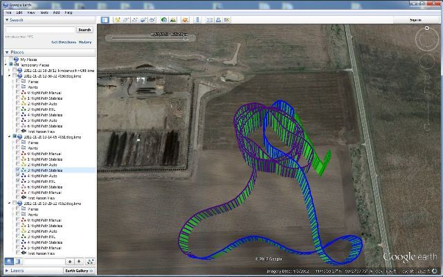
After the flight, the Mission Planner allows the Pilot to examine the Flight Data Log and chart the course as-flown in GoogleEarth. Here, the mission can be inspected to determine its accuracy and improve planning for future missions.
The U.S. Federal Aviation Administration (FAA) govern the U.S. air space.  They are still writing all the new policies concerning operation of UAVs in the U.S. air space.  An important aspect of their current regs is having two people, a pilot and co-pilot, both operating the UAV.  Our approach makes the most of this by allowing the two operators to work together.  The pilot is in control of the Transmitter and flies the UAV in traditional R/C fashion, triggering pre-programmed flight modes as needed.  The co-pilot operates the GCS, and via the telemetry, sees a virtual dashboard with flight instruments and can track the UAV real-time on the displayed map.  BOTH can control/over-ride the UAV with complementary controls.  It is a system that allows either one to operate, and for simpler missions the Pilot with Transmitter can operate the UAV alone. 

The launching and recovery of our UAVs has been made as easy and predictable as possible, and will allow the Pilot to focus on the purpose of their mission.

If the mission is simple aerial photography, it can be gathered using look-forward, look-sidesways, or look-down versions of the pod - whichever is needed for the mission.

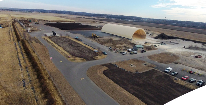
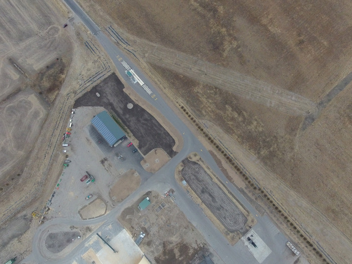
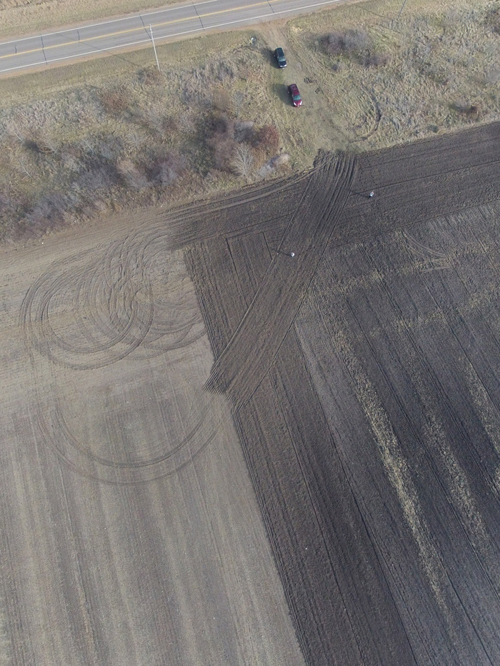
Below is a satellite photo of our testing grounds - all other images were captured from our UAVs at different altitudes over this test ground.  The RED and YELLOW circles illustrate the precision we are capable of - maintaining and repeating a circular path many times for close area surveillance. 

The above image... zoomed in with as-flown flight path overlaid.  . 

An example shot from approx. 200 m Above Ground Level (AGL) produces approximately 10 cm/pixel ground resolution - this is routine.

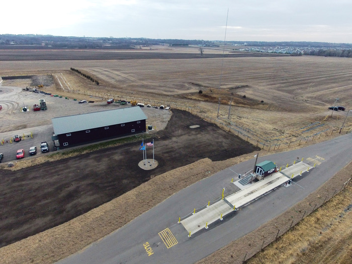
Oblique photos taken during LOITER around this site. 

For these images, the UAV was pointed into the prevailing 20 mph head wind and allowed to 'station' itself over a fixed point on the ground.  It can do this with or without the motor operating. 

A quick inspection of the chase vehicle... and pilots on the ground. 

The following is a description of the North American Robotics UAV/UAS equipment you can receive.

The Smart-Pod Mission Pod. This is the core component upon which we build the UAV and the UAS.  This rugged pod houses the autopilot, avionics, sensors, and camera.  We have intentionally test-crashed this from over 100 ft altitudes crashing at 30 mph and destroyed aircraft, but protected all internal instruments.

The Prairie Hawk and Prairie Hawk Pro UAVs.  These start as commercial R/C powered gliders, but become work-horse UAVs after some ruggedizing and the attachment of the Smart-Pod with the avionics.  The Smart-Pod stabilizes the aircraft making it extremely easy to launch, fly, and recover - often with no more pilot control than speed and steering. 

The Ground Control Station can be any of a variety of notebook PCs, brought to the field in a ruggedized Pelican case.  The GCS communicates with the UAV through the [XBee or non-XBee brand] 900 MHz transceivers.  All flight data is thus recorded on the GCS using the Mission Planner.  The Mission Planner is software running on the GCS.   Inside the Mission Planner the UAV pilot can see a satellite map or drawing of the area they plan to fly.  They plan a mission by placing Way Points on the map and assigning step by step actions to execute (such as 'loiter' around in a fixed diameter circle at a fixed height for a fixed period of time)  typically ending with Return to Launch place. 

The Transmitter we prefer is the Spektrum DX7s or DX8.  This is the over-riding control between the UAV Pilot and the GCS/UAV.  The switches on the Transmitter will be pre-programmed, and allow the UAV Pilot to switch between Flight Modes.  With the flipping of a switch the UAV Pilot can make the UAV loiter or simply fly in a circle above his or her head (taking pictures).  With the flipping of another switch, the UAV will come home from wherever it is, and with the switching of another switch the UAV will execute a pre-planned mission, much like turning on a cruise control on a car.  When the pre-planned mission is complete, the UAV returns home, where the UAV Pilot can bring it in for landing. 

The Smart-Pod makes the UAV much much easier to land than a normal R/C plane.  Most of our landings are "hands-off" with the autopilot stabilizing the UAV, all the propeller power off in a full glide, and the pilot only responsible to steer left and right.  The Smart-Pod provides a firm strong surface on which to land and protects the UAV from all but the most poorly executed landings.  We configure our UAVs to land themselves if a failsafe is triggered. 

We have done the work in configuring and tuning the aircraft, but each UAV Pilot must still accept responsibility for all of their aircraft's actions.   The FAA also recommends flying UAVs in pairs with a Pilot and Co-Pilot both in control of the UAV. 

Links to many more videos and images will be available very shortly on the updated North American Robotics website.

Read more…

Shunned technologies from the past

3689502128?profile=originalMachine Trashing (1812)

I've been doing some research on the history of technologies that, in spite of their benefits, have been misunderstood or vilified. 

A search for "shunned technology" turned up this interesting story -- about the zipper's struggle to find a place in the market during the early twentieth century:

http://www.csmonitor.com/Innovation/Pioneers/2012/0424/Gideon-Sundback-At-first-the-world-shunned-the-zipper

Some excerpts --

"Despite the devices attributes, the public was not receptive," writes fashion historian Ronald Knoth. "The pulpit decried, 'The Hookless Fastener' as 'the Devils fingers,' [because it made it easier] to remove clothing with autonomy.

...

The US Army used Sundback's interlocking teeth for gear and clothing, but zipper didn't take off in civilian clothing until 1923, when B. F. Goodrich Company wanted to innovate on the standard boot. It introduced the "Zipper Boot," the first time anyone called this mechanism a "zipper." The name stuck. 

--------------------------------------

How many of our everyday technologies had to persist against the inertial forces(fictitious forces) of fear and lack-of -imagination? I think it was many.

Read more…

How to DIY a ground station

3689501985?profile=original

Well first of all I'll start with the reason I chose to build this ground station instead of using a laptop

So after many times of carrying the laptop around assembling and disassembling parts and cables xbees usb cables and such I figured my laptop days as ground station will be numbered

Because of this I decided that I needed a ground station that would save me the need to deal with the assembling and disassembling in the field and will be more durable then my laptop

First I had to plan my shopping and inventory list

I had an old laptop with a broken screen that did not survive its frequent trips around and my poor handling skills And an older laptop screen that i planned on using with the other laptop mother board in order to do it I had to buy a lcd adapter that will let me use the vga port on the motherboard with the lvds laptop screen

That's about what I had to start with

The second thing was to look for a case that will be large enough to contain the mother board the screen another small screen that will fit in the remaining space and some lcd meters for giving a better look mostly and some 3 position switches

After many searches I found an old stock of Pelican at an affordable price and size that is suitable for my budget and needs i measured the space that left after installing the main screen and figure out that a 5 inch screen will just fit

3689502061?profile=original

then i needed to think of a way to install everything in a way that would give me easy access to the parts just for any case

3689502089?profile=original

after trying multiple materials Plexiglas plywood and others which are not very easy to work with without machinery which i didnt have access to i found just what i needed a pvc foam it is not the perfect material consider his toughness which is lacking but it is very easy to work with and so i chose it and start to cut holes and install the switches and lcds

3689502006?profile=original

for the finishing touch of the station i used a vinyl sticker in a 3d carbon woven pattern which gave the panel a nicer look

3689502162?profile=original

some technical details:

for powering the station i chose to use a sla battery instead of lipo for some reasons

first it is easier to deal with in terms of charging it and is much safer then lipo

second it is cheaper and heavier so I can save money and use it for balancing the case

i also wanted to be able to hook the station to ac power when its available

so i searched for some ac/dc converter that will meet my power demends and it turned out that i missed it in my calculation by a bit but for the moment it is working and i see no reason to change it but when it brake i'll certenly buy a bigger one capable of outputing more current

I then wanted to charge the battery while using the ac/dc convertor and giving the station more reliability i found a charger which is also a ups that is just what i wished for

also used step up regulator from 12v to 19v for powering the motherboard

and a step down regulator from 12v to 5v for powering the usb hub

both regulators are adjustable with lcd meters for convenience reasons and capable of outputting more current than consumed


bom for the station is:

laptop mother board and screen - free

pelican 1520 - ebay

LCD Controller Board DIY Kit - for connecting lvds screen to the motherboard - ebay

VGA 2AV driver board 5inch HSD050IDW1 800×480 screen - ebay

12v to 19v step up convertor with lcd for powering the motherboard - ebay

temperature meter with two sensors (inside and out of the case) - ebay

power meter with 2X lcd voltmeter and amp meter - ebay

12v to 5v step down convertor with lcd for powering usb hub - ebay

picoUPS-120 12v dc micro ups system - ebay

4X 3 position 6 pins switches - bought at a local electricity store - ebay

4X Delta Fan for Compaq 12vdc .15A 40mm EFB0412HHA - ebay

3d carbon woven pvc vinyl sticker - deal extreme

ac/dc convertor 100-240v input 12v output 3.2A or higher :) - ebay

pvc foam sheet - ebay

access point modem asus wl-330ge - ebay

usb hub 7-ports - ebay *

thermal skin for wires - ebay


I didn't really traced every buy that I made for the station but roughly everything sums for less then 400$ in total


- ebay is not the cheapest by any mean


* if you want to build your own usb hub you can do it using fe1.1s chip or similar very easily

**and so on with the other regulators it is just to my believe cheaper and faster to order it assembled :)


features of the station:

up to 2.5 hours of use on a single 12v 7Ah sla battery

secondary screen switchable between av and vga (via pc hdmi port and vga converter)

wireless connection to antenna tracker (xbee repeater, Bluetooth, 5.8Ghz)

access point modem - for multiple connection to the station (andropilot for ex)

can be easily modified and upgraded

sorry for my poor writing and description capabilities/skills


3689502031?profile=original3689502181?profile=original

the uav station is not complete yet still need to do some more things so I will update the post as It go

Read more…

Sky9x board in danger of dying out...

~master~master~~master5.JPGMany of you might know the Sky9x upgrade board for 9x-model Chinese radios. It boasts an ARM Cortex M3 32bit processor and a whole bunch of additional features, such as audio out, SD card for saving configs, USB programming interface and so on. It runs on the very feature-rich and mature open source firmware Open9X. It has a PPM out, so with the right connector board, it can run with any TX module, may it be Futaba, JR, FrSky, Orange, Lemon, whatever...

The official feature list:

-  Atmel SAM3S Arm Cortex M3 32 bit Microprocessor (256K EPROM , 48K RAM , 64Mhz)
 - Built-in USB port for loading new firmware , and to access the SD card as a Mass storage device.
 - Connector for LED Backlight , with software dimming control
-  1/2 Watt  audio amplifier with 8 Ohm Speaker Output  and support for a headphone jack
-  4Mb EEPROM provides on board storage for 20 - 40 models depends on software used.
- Support for Koycera  64x128 LED backlight LCD  
- Two , internal RS232 Serial communication ports  with support for external 2.5mm jacks..
- FrSky Telemetry can hook directly up to board (no convertors needed)
- Micro SD Card Socket for Sound , Model and Telemetry logging / storage.
- One , TTL Serial Port , for hookup to a Bluetooth Module , Like RN-42
- Hardware PPM , PXX output   .
​- Haptic Output connector
- AVR Co-Processor , ATtiny167 AVR  , provides 12 more I/O channels and  provides  RTC
  (Real Time Clock) functions , with on board 3V Lithium Battery
- On Board CR2032 Lithium Battery Holder  
- On Board Current Sensor monitors the current being drawn from the battery, and stores
  the amount of mAH used up.
- 5V Linear Pre - Regulator  supplies the Main LDO 3.3V Linear Regulator. For better heat management, and a 5V Switching Regulator Upgrade is available for using  3S Lipo batteries

In my opinion, this board is great! It's way too good to be seen just as an upgrade for the 9x transmitters. It also makes a very nice base for every DIY-transmitter project - that's why I selected it as the RC core for my intergrated groundstation project.

Now, unfortunately, the board is in danger of dying out! Brent, the designer and the guy who makes those great boards as a hobby, wrote in the 9x-forums that problems in the last production run left him 25 boards short, leading to a loss of ~$2500. A pretty big sum for a hobby project!

If you have a 9x transmitter and are looking for more features, if you always wanted to build your own TX or if you are planning to build a version of my UAV Control Station, once my software is getting mature, have a look at the Sky9X-board! Brent wrote that if he gets enough people to pre-order for another production run, the board will continue to live. Otherwise, it will die...

Check the website here: http://www.ersky9x.net/

Read more…
3D Robotics

3689501834?profile=originalFrom Wired's Danger Room:

When the flying robots that loiter in Afghanistan’s and Yemen’s airspace come home, they won’t just be headed for the local police station. They might prefer a pastoral existence of spraying crops, scanning soil patterns and other features of America’s farms.

No, Predators and Reapers aren’t going to scan large swaths of vegetation for suspected militants. And there’s tremendous interest from state and local law enforcement in drones as surveillance tools. But to Chris Mailey, a vice president with the drone promotion organization known as AUVSI, the cop shops represent short money. “Agriculture,” Mailey tells Danger Room, “is gonna be the big market.”

To Mailey, it’s a question of where the growth opportunities are. Military drone purchases are plateauing, even as the drones become increasingly central to U.S. counterterrorism. And there are limits, financial and otherwise, to the ability of police departments to purchase drones. Farming looks like a drone market with both fewer impediments and bigger incentives for early technological adoption.

“A manned crop sprayer is flying 10 feet above his crops — how accurate is it? Any crop you spray that isn’t on your farm you have to pay for, and a remote-controlled ‘copter can be very precise,” Mailey says. “Spraying, watering — there’s a whole market for precision agriculture, and when you put that cost-benefit together, farmers will buy [drones].”

AUVSI intends to publish a study in the next few weeks anticipating the scope of the domestic, non-military market for drones. But there’s already some data to support Mailey’s hypothesis. “Precision farmers” love using data tools to increase crop yields. In 2009, an Idaho farmer homebrewed his own drone, slapped a commercial digital camera on it, and began extracting data on soil patterns to help his business expand. Companies like CropCam build lightweight, modular, GPS-driven gliders to give farmers an aerial view of their fields without requiring pilot training or the expense of buying a small manned plane. Of course, this is all dependent on drone manufacturers pricing their robots inexpensively enough for farmers who also have to buy a lot of other expensive equipment to ply their trade.

Japan also provides some indication of the potential demand for drones by farmers. Yamaha introduced its RMAX unmanned helicopter for crop-spraying in 1990. By 2010, the drone ‘copter and its robotic competitors — some 2,300 of them — sprayed 30 percent of Japanese rice fields with pesticides, according to a recent Yamaha presentation. The Japanese farm hectares sprayed by manned helicopters dropped from 1,328 in 1995 to 57 in 2011, as unmanned helicopter spray rose to 1,000 hectares that year.

Closer to home, last year the Electronic Frontier Foundation, using the Freedom of Information Act, obtained data from the Federal Aviation Administration detailing who’s been cleared to operate drones in U.S. airspace. Local, state and federal police and homeland-security agencies had received 17 certificates of authorization for flying drones. Universities received 21 of them. “All those universities are focused on agriculture,” Mailey says.

Of course, your local police, if they can, are very likely to buy drones, ushering in a new era of tech-enabled aerial privacy erosions. Several already have — although a full list is unavailable — like the Miami-Dade Police Department, whose use of Honeywell’s T-Hawk spy drone I profiled in the December 2011 Playboy. (Link is SFW.) Mailey’s argument is that there’s a hard limit of 18,000 law enforcement agencies in the U.S., many of which may not be able to afford the expense of what could be argued is an optional piece of hardware that can run into the hundreds of thousands of dollars and requires cumbersome FAA licenses. (Which, in fairness, farmers will need as well.) Put a different way, Mailey and AUVSI forecast a steeper growth in the drone market for farms than it does in the drone market for law enforcement — but it sees both on the rise.

The biggest reversal? While the U.S. market for drones is “almost 100 percent military,” Mailey puts it, the drone industry doesn’t think it can rely on the Defense Department much longer. Last year, the Pentagon indicated in a congressional report that it was going to level off most of its drone purchases through 2017; it currently spends about $6.5 billion annually on unmanned robotic systems. Maintenance and replacement-level purchases, rather than inventory expansions, is likely to characterize drone purchases — at least until the Navy’s carrier-based drone joins the fleet at the end of the decade.

“There’s still a lot of money [in military drones], but it’s more predictable,” Mailey says. “This wild wild west we’ve had is consolidating.” Sounds like time to farm.

Read more…
3D Robotics

Raffaello D’Andrea from ETH (home of PX4!) wowed them at Zurich Minds. From Robohub:

During the 20 minute presentation, Raffaello D’Andrea revealed some of the key concepts behind his group’s impressive demonstrations of quadrocopters juggling, throwing and catching balls, dancing, and building structures – and illustrated them with live examples with quadrocopters flying on stage.

To watch him hurtle quadrocopters towards his audience, see them juggle balls and balance poles, and to find out what happens when control fails, check out the video:

Read more…
3D Robotics

3689501738?profile=originalA very sensible opinion piece in the Washington Post, which discusses us. A couple small technical errors (most DIY Drones aren't controlled by WiFi), but otherwise one of the best I've seen:

Here's how it starts:

The drone debate we need to have

By Vivek Wadhwa

Last week, a Virginia House panel approved a two-year moratorium on drone use within the state. In December, Berkeley’s City Council debated a similar proposal from its Peace and Justice Commission. The commission wanted to prohibit the city from purchasing, borrowing, testing or using drones, or allowing “drones in transit.” Hobbyists would, however, have been allowed to use drones which didn’t carry cameras or audio surveillance equipment. The legislation was shot down because, as Berkeley Councilman Gordon Wozniak argued, “Berkeley doesn’t have jurisdiction over its airspace and can’t enforce it unless we buy Patriot missiles to shoot things down.” Both of these bills were prompted by law enforcement officials wanting to use drones for surveillance and intelligence gathering.

The American Civil Liberties Union (ACLU) calls this “spying.”

These are the harbingers of debates to come as the Federal Aviation Administration (FAA) moves towards approving the use ofUnmanned Aircraft Systems for law enforcement. Groups such as the ACLU are working to stop this because of concerns over privacy. As M. Ryan Calo, my colleague at Stanford Law School and Director for Privacy and Robotics at theCenter for Internet & Society, has written, U.S. privacy laws don’t address these issues. This means we are in for some significantlegislative battles on Capitol Hill and in the Supreme Court. Calo says these “could be just the visceral jolt society needs to drag privacy law into the twenty-first century.”

No doubt, privacy is an important issue. But this is going to be the least of our concerns as drone technologies advance further. We are entering the “drone age” writes drone-builder Chris Anderson, whose company 3D Robotics sells drone kits to mix and match capabilities. With sensors, optics, and embedded processors advancing exponentially and prices dropping precipitously, do-it-yourself-ers are building even more sophisticated and smaller drones than what the U.S. government had a few years ago.


Read the rest here. 

Read more…

Dro' Rida

3689501689?profile=original


Years ago I had run across this old post from rec.aviation.military, "Weird question":


From: Mary Shafer <shafer@reseng.dfrc.nasa.gov>
Newsgroups: rec.aviation.military
Subject: Re: Weird question: Date: 08 Apr 1998 11:56:55 -0700
"Zorak" <someone@somewhere.net> writes:
> I have a weird question: has anyone attempted to convert a cruise missile
> like the tomahawk into a piloted aircraft? (without the warhead, of course!)
> I think I remember hearing once that some woman had a piloted version of the
> tomahawk.

In 1993 two employees of Scaled Composites reported on "Manned Test
Flight of an Unmanned Air Vehicle" at the SETP Symposium. However,
they didn't get a written version into the Proceedings, so that's
about all I can say specifically. The general technique involved
adding a very limited instrument panel and pilot controls, with the
pilot straddling the vehicle, I think somewhere near the cg. I
believe they provided a backrest and foot pegs for pilot stability.
Shades of Slim Pickins, which is what came to everyone's mind
immediately on seeing the picture pf the pilot riding the vehicle.

Regarding the identity of the vehicle, all I can say for sure is that
it wasn't a Tomahawk. I don't remember what it was and don't think it
was a cruise missile anyway.
--
Mary Shafer NASA Dryden Flight Research Center, Edwards, CA
SR-71 Flying Qualities Lead Engineer Of course I don't speak for NASA
sha...@reseng.dfrc.nasa.gov DoD #362 KotFR
URL http://www.dfrc.nasa.gov/People/Shafer/mary.html
For personal messages, please use sha...@ursa-major.spdcc.com

It took me a while, but eventually I was able to acquire a photo of the flight in question through a well-placed contact.

Apparently this Raptor drone later crashed.

Post links to other drone riders you're aware of!

Read more…

UxV-CS PFD is ready

What happens if you lose line of sight to your UAV or your FPV videolink breaks down?

If you still have a working telemetry link, the PFD-display of the UxV-CS might just help you bring your bird back in one piece. It shows a simplified attitude indicator (the display isn't designed for heavy graphics), a compass rose with a heading bug showing the bearing to the home location and airspeed, speed over ground, vertical speed and altitude. If you know your terrain, with that data you should be able to get you UAV back into LoS / FPV-range.

Read more…
3D Robotics

RobpLab box for classrooms

3689501675?profile=originalEvan Ackerman at IEEE Spectrumreports:

This is the RobotsLab Box. It's a giant box, and it's full of robots. As if that wasn't enough, it's also full of a tablet which is full of a complete STEM (science, technology, engineering, and math) curriculum that uses the robots as tools to show things like math and physics in action. The Box is designed to make it easy and affordable for teachers to drop a bunch of awesome robots right into the classroom, and even though I'm not a teacher or a student, I want one.

Inside the Box (it really is just called "the Box") you'll find an AR Drone, a Sphero robotic ball, a Mobot two-wheeled modular robot vehicle, and an Armbot robotic arm. To control them all, you also get a tablet. By itself, this wouldn't be that interesting, but what makes the Box valuable is that it's got everything on it that someone who's not a robotics expert needs to teach a classroom of 7th to 12th graders something that they might actually remember. There are detailed step-by-step instructions on how to get the robots to not crash and/or blow up, comprehensive lesson plans, and even quizzes. You get 50 different individual lessons, plus an option for 30 more. 

We love this idea, but the question here is really going to be whether the included curriculum is able to justify the added expense and complexity of the robots. The Box costs $3,500, and if you were to buy the robots separately at retail prices, you'd end up paying $300 for the AR Drone, $130 for Sphero, and about $300 for the Mobot. I'm not sure exactly what the Armbot is, but if we're looking at something similar, it might set you back $400 or $500. Add a tablet for perhaps $500 on the outside, and you can duplicate all of this hardware for something under $2,000, putting a $1,500 premium on software, curriculum, and support.

So, okay. That seems generally reasonable, although we're by no means qualified to make a determination like that for teachers. Really, what we're wondering is whether or not the robots will be integrated into the curriculum in such a way that they're more than a gimmick at best, or a distraction at worst. Here's what the RobotsLab people have to say about this:

Robots are used to expose scientific principles providing a bridge between the abstract topics and the real world. Students will have to practice equation solving skills, understanding of physical forces and scientific investigation thinking in order to solve the quizzes. Each robot included in the box was carefully chosen by our team because of its ability to demonstrate the scientific principles, its ease of operation and its durability.

We got a look at one of the 50 lessons that will be included in the box, and here's a sample, focusing on something called "quadratic equations," whatever those are:

Quadratic Search & Rescue– Quadratic Formula Creation

General Information:

This lesson demonstrates quadratic function based on area. The story plot behind the lesson is that a quadcopter was sent to a search and rescue mission using its bottom camera. The higher the quadcopter flies the bigger the area covered by the camera. The relationship between the height and the area covered is quadratic. (The relationship between the height and an edge of the image is linear, edge X edge is edge squared.)

Lesson Objectives:

This lesson demonstrates what a quadratic graph looks like and how it associates to area. It also helps to relate a quadratic function to the physical world

Lesson Tasks:

Students are first presented with a demonstration of how the helicopter system works along with the video camera located on the bottom of the A.R. Drone

Helicopter run through a 'demonstration mode' where it takes off and begins to hover at a certain height. The students should take note of how much area is viewable from the camera. The helicopter then climbs in elevation and pauses, followed by a drop in elevation closer to the ground. The helicopter finally lands and the demonstration is over. As the camera height is adjusted, what conclusions can you form between the relationship of the viewable area of the camera and height?

Given a situation where the dimensions of the viewable area and the height of the helicopter are known, what is a quadratic function that can be used to describe the helicopter's height in terms of viewing area?

Based on this deduced formula above, use it to figure out the height of the helicopter when the image area is given? Demonstrate this with the A.R. Drone. Use this same formula to determine the image area when the helicopter is a given distance from the ground.

You know what? I used to work for a company where I had to do exactly this. Score one for robots teaching real world skills!

Of course, there's a bunch more included in the lesson plan, like detailed checklists for teachers as well as quizzes for students that are aligned with teaching standards. Here's RobotsLab CEO Elad Inbar talking about the Box, and giving a brief example of the quadratic formula lesson:

If you recognize Elad, it's because he's also the CEO of RobotAppStore. In fact, RobotsLab is the same company- it's just the educational division, which also includes a dedicated panel of 14 teachers. It's probably not a coincidence that Grishin Robotics invested a quarter million bucks into RobotsAppStore at the end of last year, and Elad has told us that Dimitri Grishin is "involved and excited," since "[RobotsLab's] work with the educational industry is definitely aligned with his vision of how the 21st century class room should look like." We here at Spectrum take that to mean that 21st century classrooms should be full of robots, which is a sentiment that we heartily approve of.

RobotsLab Box is launching today at the Texas Computer Education Association (TECA) conference down in Texas. It looks like it's available now at the website below, and we're definitely excited to see how fast this concept catches on. We're also excited to see what else might be possible here: with all of this hardware, we'd love some lesson plans that encourage students to get their hands dirty playing with the robots themselves as well.

Read more…
Distributor

Stuck in the mud?

3689501496?profile=original

Hard landings with my 3DR quad always puts it firmly 3 inches into the ground, splitting the legs up and destroying the nylon spacers.

I created these very simple bumpers so i don't have to dig up my quad anymore:

3689501664?profile=original

They are made from pipe insulation and a wooden hub from a broomstick i had laying around.

I cut up the stick in four 18 mm pieces to replace the nylon spacers and drilled a 3 mm hole in the center.

CA glued the hub to the middle of the foam piece and cut openings for the two legs.

Finally i replaced the two short 3 mm screws with a longer one that goes through both legs and the hub, securing it with a locknut.


3689501545?profile=original

3689501716?profile=original

3689501629?profile=original

Read more…