Finally got some time to put together some footage, more videos to come
Hope you guys like it!
Finally got some time to put together some footage, more videos to come
Hope you guys like it!
Posted 8 Apr 2013 at 15:07 UTC by John_RobotsPodcast
We Robot: Getting Down to Business is the title of the 2nd annual conference on robotics and the law, being held today and tomorrow at Stanford Law School. With several contributors in attendance, Robohub.org will be providing live coverage of this event. Check back frequently for updates
WASHINGTON – The dawn of the age of aerial civilian drones is rich with possibilities for people far from the war zones where they made their devastating mark as a weapon of choice against terrorists.
The unmanned, generally small aircraft can steer water and pesticides to crops with precision, saving farmers money while reducing environmental risk. They can inspect distant bridges, pipelines and power lines, and find hurricane victims stranded on rooftops.
Drones — some as tiny as a hummingbird — promise everyday benefits as broad as the sky is wide. But the drone industry and those eager to tap its potential are running headlong into fears the peeping-eye, go-anywhere technology will be misused.
Since January, drone-related legislation has been introduced in more than 30 states, largely in response to privacy concerns. Many of the bills would prevent police from using drones for broad public surveillance or to watch individuals without sufficient grounds to believe they were involved in crimes.
Stephen Ingley, executive director of the Airborne Law Enforcement Association, says resistance to the technology is frustrating. Drones “clearly have so much potential for saving lives, and it’s a darn shame we’re having to go through this right now,” he said.
But privacy advocates say now is the time to debate the proper use of civilian drones and set rules, before they become ubiquitous. Sentiment for curbing domestic drone use has brought the left and right together perhaps more than any other recent issue.
“The thought of government drones buzzing overhead and constantly monitoring the activities of law-abiding citizens runs contrary to the notion of what it means to live in a free society,” Sen. Charles Grassley, a Republican, said at a recent hearing of the Senate Judiciary Committee.
With military budgets shrinking, drone makers have been counting on the civilian market to spur the industry’s growth. Some companies that make drones or supply support equipment and services say the uncertainty has caused them to put U.S. expansion plans on hold, and they are looking overseas for new markets.
“Our lack of success in educating the public about unmanned aircraft is coming back to bite us,” said Robert Fitzgerald, chief executive of the BOSH Group, which provides support services to drone users.
“The U.S. has been at the lead of this technology a long time,” he said. “If our government holds back this technology, there’s the freedom to move elsewhere . . . and all of a sudden these things will be flying everywhere else and competing with us.”
Law enforcement is expected to be one of the bigger initial markets for civilian drones. Last month, the FBI used drones to maintain continuous surveillance of a bunker in Alabama where a 5-year-old boy was being held hostage.
In Virginia, the state General Assembly passed a bill that would place a two-year moratorium on the use of drones by state and local law enforcement. The measure is supported by groups as varied as the American Civil Liberties Union on the left and the Virginia Tea Party Patriots Federation on the right.
Gov. Bob McDonnell is proposing amendments that would retain the broad ban on spy drones but allow specific exemptions when lives are in danger, such as for search-and-rescue operations.
Seattle abandoned its drone program after community protests in February. The city’s police department had purchased two drones through a federal grant without consulting the city council.
In Congress, Rep. Ed Markey, a Democrat and cochairman of the House’s privacy caucus, has introduced a bill that prohibits the Federal Aviation Administration from issuing drone licenses unless the applicant provides a statement explaining who will operate the drone, where it will be flown, what kind of data will be collected, how the data will be used, whether the information will be sold to third parties and the period for which the information will be retained.
Privacy advocates acknowledge the many benign uses of drones. In Mesa County, Colorado, for example, an annual landfill survey using manned aircraft cost about $10,000. The county recently performed the same survey using a drone for about $200.
Drones can help police departments find missing people, reconstruct traffic accidents and act as lookouts for police special tactics teams. Real estate agents can have them film videos of properties and surrounding neighborhoods, offering clients a better-than-bird’s-eye view — though one that neighbors may not wish to have shared.
“Any legislation that restricts the use of this kind of capability to serve the public is putting the public at risk,” said Steve Gitlin, vice president of AeroVironment, a leading maker of smaller drones.
Yet the virtues of drones can also make them dangerous, privacy advocates say. The low cost and ease of use may encourage police and others to conduct the kind of continuous or intrusive surveillance that might otherwise be impractical.
Drones can be equipped with high-powered cameras and listening devices, and infrared cameras that can see people in the dark.
“High-rise buildings, security fences or even the walls of a building are not barriers to increasingly common drone technology,” Amie Stepanovich, director of the Electronic Privacy Information Council’s surveillance project, told the Senate panel.
Civilian drone use is limited to government agencies and public universities that have received a few hundred permits from the Federal Aviation Administration. A law passed by Congress last year requires the FAA to open U.S. skies to widespread drone flights by 2015, but the agency is behind schedule and it is doubtful it will meet that deadline. Lawmakers and industry officials have complained for years about the FAA’s slow progress.
The FAA estimates that within five years of gaining broader access about 7,500 civilian drones will be in use.
Although the Supreme Court has not dealt directly with drones, it has approved aerial surveillance without warrants in drug cases in which officers in a plane or helicopter spotted marijuana plants growing on a suspect’s property.
But in a case involving the use of ground-based equipment, the court said police generally need a warrant before using a thermal imaging device to detect hot spots in a home that might indicate that marijuana plants are being grown there.
In some states economic concerns have trumped public unease. In Oklahoma, an antidrone bill was shelved at the request of Republican Gov. Mary Fallin, who was concerned it might hinder growth of the state’s drone industry. The North Dakota state Senate killed a drone bill in part because it might impede the state’s chances of being selected by the FAA as one of six national drone test sites, which could generate local jobs.
A bill that would have limited the ability of state and local governments to use drones died in the Washington legislature. The measure was opposed by the Boeing Co., which employs more than 80,000 workers in the state and which has a subsidiary, Insitu, that is a leading military drone manufacturer.
Sen. Rand Paul, a Republican, recently drew attention to the domestic use of drones when he staged a 13-hour speech, demanding to know whether the president has authority to use weaponized drones to kill Americans on American soil. The White House said no, if the person isn’t engaged in combat. Industry officials worry that the episode could temporarily set back civilian drone use.
“The opposition has become very loud,” said Gitlin of AeroVironment, “but we are confident that over time the benefits of these solutions are going to far outweigh the concerns, and they’ll become part of normal life in the future.”
www.rcdetails.info
During last several months, a lot of items were added or updated.
New filters for motors, servos, lipos, ESCs etc:
new methods for searching similar products:
and statistics. DB contains:
>1300 brushless motors;
>300 gas and glow engines;
~900 servos;
>500 ESCs;
~1400 propellers;
>1500 lipo.
Welcome!
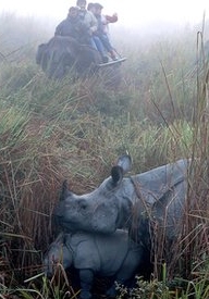
Something close to my heart, I am currently ramping up for a radio collar trial in South Africa with some new technology. Rhinos are just one animal in great danger. Time to redress the balance. GM
by Abdul Gani
Kaziranga National Park, for the first time is to witness a test flight of the much anticipated unmanned aircraft on Monday in presence of Wildlife Institute of India (WII) Scientist, Dr. K. Ramesh who leads the monitoring programme, said Rakibul Hussain, Minister for Environment and Forests at press conference today. This test is to begin tomorrow and extend till April 11 so as to understand all measures that will be required for implementation of the unmanned aircraft for better surveillance at the national park.
It is to be mentioned that Assam Chief Minister Tarun Gogoi has been pressurising the Central Ministry for a CBI enquiry in to the unabated poaching of endangered one horn rhinoceros. The CBI has now accepted the State Government’s request to probe into this matter. Hussain also said that the Chief Minister has welcomed CBI’s gesture and has promised to extend full support to control the illegal activities at this national park. The unmanned aircraft is one of the measures undertaken by the State Forest Department and National Tiger Conservation Authority (NTCA) which could be one effective measure to keep a track of events at the national park. Minister also emphasised that use of this advance technology will help to monitor unwanted movements of the poachers and thus keep a track. Though a clearance is yet to be acquired from the Defence Authority but once the test is cleared the Minister is hopeful for its implementation at the earliest.
The minister ascertained that an unmanned aerial vehicle would also soon be inducted for better surveillance of the park to prevent poaching of rhinos and other wildlife. He also informed about a workshop to be held on April 20 at Kaziranga wherein Keshav Kumar, Joint Director, CBI from Mumbai will train the Field Directors of North East and Central India to combat and sharpen their investigative directives against such poaching.
Following a positive meeting with the Federal Aviation Administration (FAA), the entrepreneurs behind Hoverfly Technologies are moving forward to create a new industry association and a Flight School certification program for aerial robot operators across the nation.
Hoverfly met with Michael K. Wilson , Southern Region Program Manager for Unmanned Aircraft Systems at the FAA, on March 25.
A major function of the FAA includes regulating commuter and commercial aviation. While there is not a specific rule in place that prohibits the commercial use of aerial robots, it is currently not the policy of the FAA to authorize the use of such robots.
During the meeting, it became evident that an industry standard for operations safety needed to be established before Hoverfly could move forward in creating a new Flight School. In response, Hoverfly reached out to community and other industry leaders and formed a group to establish a new industry association — the Aerial Robotics Industry Association (ARIA).
Hoverfly Technologies will be starting its own ARIA-certified Flight School immediately. Instruction will focus on safe operation of aerial robotics and will be based on the ARIA "FlySafe" standard.
The inaugural meeting of ARIA will take place in May in concert with the first Flysafe Flight School class May 17-19, 2013.
I'm a loyal AUVSI (Association of Unmanned Vehicle Systems International) member, but this is just sad. In an effort to distance the industry from public perceptions around the word "drone" at a congressional hearing last week, they said this:
“This is more than a pilotless vehicle,” Michael Toscano, president of the Association for Unmanned Vehicle Systems International, said at Leahy’s Senate Judiciary Committee hearing, convened to consider privacy risks. “There’s nothing unmanned about unmanned systems.’’
First of all, what?? Second, it may be that there are 60+ people in ground support for each Global Hawk in the air, but that's sure not the case for the smaller drones, including the ones we fly. At the moment we still usually keep one "pilot" on the ground (guy just watching and able to take over manual control if needed) for each drone in the air, but that's just a safety measure. These things take off, run their mission and land autonomously. When all goes well, there's no human in the loop at all.
Either the AUVSI is out of touch with what's really going on with drones, or they're backing themselves into a rhetorical corner that they won't be able to get out of.
(Photo of CyFly tethered drone from Boston Globe article linked above)
During a 4 weeks mission to Peru we have done several UAV flights for mapping purposes. These included flights at high altitude over the Andes. The highest one was over the scenic “Bosque de Piedras”, at 4500m altitude, where we have mapped a 1km2 area in a matrix flight pattern.
- Images processed with PIX4D -
These flights fit within a Belgian - Peruvian cooperation (KU Leuven – UNALM) to study and improve agricultural production in coastal, Andes and Amazon areas of the country. Special thanks to all the developers here at diydrones, dedicated to make Arduplane rock-solid and performing well under difficult conditions. During the 30+ autopilot missions, Arduplane never failed and we managed to finish the project with one X8 frame, despite the harsh conditions (rainy season, high altitude, challenging landing spots..). Below a road-movie from the Andes part of the trip:
I´ve succeeded to use the DroidPlanner (by A. Benemann) software with my Arducopter using a 3DR telemetry link in a real flight tests on the field.
To do that you'll need a couple of things:
- OTG (On The Go) USB cable (3€ in Amazon)
- A "rooted" Android terminal. I´ve used my Nexus 7. (Please google for how-to "root" an Android terminal).
I've got it working really quite straight forward:
- connect the 3DR Tx on the N7 (see video attached)
- select "USB" as "Telemetry Connection Tipe"
- enjoy...
This is thanks to the great work done by Arthur Benemann on this software. It really worths. See this post.
Main performances work very well. Video attached shows main use tips.
Below some ideas for future updates and comments:
- next update suggestions:
- should have a parameter edition: this is a must. Very important
- edition of WP´s
- How to use offline maps?
Small bugs to correct:
- guided works well but altitude is not specified (lift to the infinite and beyond)
- Text to speech only works in some pages (not in all)
- Changiing from "flight data" page to "planning" page brakes the program.
I don't know if this mode allready exists in the latest APM (arducopter) firmware. But I'm currently working on a project and I'm using arducopter firmware 2.5.3. To control my quad I use the joystick feature in the APM planner. But I'm not using a joystick I'm using a gamepad.
As you know gamepads always center there stick and it's hard to get a stick value that is not MIN, MAX or CENTER. It's to sensitive to have a good throttle control.
Now I'm implementing a gamepad throttle mode for my project (in the arducopter v2.5.3 firmware)
A very simple/basic overview of what is happing in the code:
When flying in THROTTLE MANUAL MODE then
-> throttle value = stick position
When flying in THROTTLE GAMPAD MODE then
-> stick posistion = center? do nothing: leave throttle at it's current position
-> stick posistion = down? decrease: throttle value = throttle value - some value
-> stick posistion = up? increase: throttle value = throttle value + some value
This way it's much more easy to control the throttle with a gamepad and to hold it on a fix position. But it also has some disadvantages. Increasing or decreasing to full max or full min will take some time. But if someone would work this out this gampad mode could be tuned with configurable sensitivity values etc to minimize the disadvantages.
here is a little concept video:
If last week’s FAA “online public engagement” session was any indication, you can never quite tell what people are going to say about unmanned aircraft and drones.
Obviously there are major concerns, some of them justified, about unmanned aircraft and privacy. The answer is not to hide from these questions, or avoid interviews.
Thursday, I was joined by Chris Anderson of 3DRobotics (a company which provides aerial robotics components, some of which I use for drone journalism and STEM education), and Nancy Cooke, Science Director of the Cognitive Engineering Research Institute in Mesa, Arizona, for a call-in radio program about unmanned aircraft systems (UAS) on the NPR affiliate WILL.
We covered a wide range of topics, from the basics of “what is a drone?,” to the many applications for UAS, including STEM education, cargo transport, and journalism. Most of the questions from our callers involved privacy, so a lot of discussion happened around laws and regulations.
WILL’s website includes an MP3 of that radio program, along with a video interview that producer Lindsey Moon put together. The video includes an introduction to the AR.Drone 2.0 quadcopter, which I flew around WILL studios to demonstrate how it hovers and records video.
By Mark Walker
San Diego’s “drone zone” manufacturing hub is under fire from groups opposed to unmanned aerial vehicles carrying out deadly overseas strikes and serving as furtive eyes in the sky for domestic law-enforcement agencies.
A series of small protests that began Thursday in this region continued Friday and is set to culminate this afternoon at the USS Midway Museum in downtown San Diego.
The demonstrations are part of a nationwide effort by activists seeking to focus attention on a growing debate over the technology, one that runs from Congress to think tanks to classrooms. They’re occurring as a business and military coalition seeks to have the region declared as a national test zone for drones, which generate more than $1 billion a year for the local economy.
http://www.utsandiego.com/news/2013/apr/06/tp-unmanned-aerial-vehicle-proliferation-protested/
I have been interested in the world of UAVs and quadcopters for some time now, but have never moved much beyond my few single rotor RC helicopters. Back in December, I purchased my first quad, a HeliMax 1SQ to try my hand at flying something other than single rotor helicopters. It is a fun little quad, but very limiting in ability to carry anything. As I am wanting to do some aerial video, I decided to move up. But to what?
Not wanting to have too much invested in a quad which I could possibly ruin, due to my lack of flying skills, I decided to go for something cheap. And this is how I found the WLtoys V959 camera equipped quadcopter. For less than $70 it is an all-in-one RTF package, with a 60fps standard def camera built-in. I find the integrated camera, mounted against vibrations, and running at 60fps, really helps minimize the jello effect seen with the keychain cameras others have put on these micro-quads, although the lack of high definition, or even wide angle, is a little disappointing. But, for the cost, I can't complain, much.
I may add an 808 #16 keychain camera to try HD, and possibly attempt some FPV with this helicopter. I have done some tests, and find it should be able to lift at least fifty additional grams without much modification. While the WLtoys V959 is on the lower end of quadcopters, I personally think this was a good investment for me. To repeat an analogy a friend of mine used, this is the Cessna to a 747. Just as a pilot wouldn't buy a 747 to learn flying on, I felt it unnecessary to invest several hundred, or more, on a high-end quad, when all I really am wanting to do now is get the basics.
uFusion is an easy configurable 9DoF AHRS system that mix data coming from 3 axes accelerometer, 3 axes gyroscope, 3 axes magnetometer to extract Attitude and Heading References. It’s studied to simplify the integration in your project. In fact, uFusion can be soldered on your own PCB or can be used through its motherboard.
uFusion data output can be read with 2 type of standard communication: UART or SPI. Additionally, the motherboard allow to read data using the USB 2.0 standard.
More information here: http://www.indiegogo.com/projects/ufusion-ahrs-system
From the Southeast Farm Press (via sUASNews)
Welcome to the future of agriculture with remote-controlled helicopters and unmanned aircraft equipped with imaging sensors.
Farmers and technology experts from across the Southeast got a glimpse of the future recently at the Atlanta Chapter of the Association of Unmanned Vehicle Systems International’s Unmanned Systems in Agriculture Conference at the University of Georgia Tifton Campus Conference Center.
Unmanned vehicle developers hope the new technologies will make farming more cost effective, and better for society and the environment.
“This unmanned aerial systems conference is really important because it’s highlighting existing technology, which can have immediate impact on agriculture,” said Joe West, assistant dean of the UGA Tifton Campus.
“It’s demonstrating how unmanned aerial systems, which were developed with military applications, are transferring that technology over to agriculture where we’re essentially using those systems as platforms to carry technology to monitor crops and many other things; disease, drought, mineral deficiencies.”
Unmanned autonomous systems are becoming more common place as a tool for farmers, according to the Association of the Unmanned Vehicle Systems, also known as AUVSI.
Scientists are already using remote-controlled helicopters to detect diseases in farmers’ fields. Unmanned helicopters are also popular in Japan where more than 2,300 are used to spray rice fields and keep a close watch on the health of crops.
“Agriculture is very technology-oriented,” West said. “We’re very advanced from the science standpoint, technology standpoint, even business standpoint. It’s going to be another tool that lets us reach further, make decisions better and then respond quicker.”
One of the remote-controlled helicopters at the conference Thursday, the Aerobot 100, was designed to be used as an eye in the sky for the military, police or fire department. With a camera attached on its bottom, the Air Robot 100 allows its user to get a bird’s eye view of areas that are otherwise inaccessible.
For example, it would provide another set of eyes for the fire department to see how many people are trapped in a burning building.
Producers who farm large fields could use the machine to inspect crops for insect or disease damage. Using the Air Robot 100 could help farmers identify an emerging insect or disease problems before it’s spotted by crop scouts.
“This is not specifically an agricultural UAV (unmanned aerial vehicle) but it has a lot of potential. I think it’s representative of the class of UAVs that people who may come to this conference wouldn’t have known about,” said David Price, a senior research technologist with Georgia Tech.
Price operated the Aerobot 100 with a remote control that also displayed video of what was being filmed.
More and more universities around the country are studying unmanned aerial vehicle technology in agriculture. Highlighted by AUVSI, Virginia Tech uses unmanned aerial vehicles to locate microbes in the atmosphere that could lead to plant diseases. The research conducted will be used to create an early warning system for pathogens.
As fewer people work on the farm, adopting these new technologies could play a key role in the success of farms everywhere.
“It makes our farms more efficient. It makes them more sustainable and environmentally friendly,” West said. “Change is difficult. Adopting new technologies is difficult, especially if you’re older and haven’t been exposed to technology as much …
“Adoption is more difficult. However, there’s one thing that makes adoption easy, and that’s if it makes money.”
From TechCrunch:
If you’re into 3D printable stuff, or into remote-control cars, then the OpenRC Project is for you. A gentleman in Sweden named Daniel Norée is sharing his progress on a 3D-printed Truggy, as well as sharing the recipe with theOpenRC Project group that he created. A truggy is an off-road vehicle, in case you weren’t sure.
The cost of 3D printers is dropping both for at-home use and enterprise, so it’s a very real possibility that consumers all over the world could soon have these devices in their living rooms. Crazier things have happened. We’ve seen 3D-printed iPhone docks, violins, pottery and even a robotic hand for a child.
If you can print out your very own customized remote-control car with one, count me in. While not all of the parts are printable, such as the wheels, for really die-hard remote control car fans, those are parts that they probably have sitting around in the garage already.
Above is a video that Norée uploaded today that shows some of the schematics behind the parts, and the actual 3D-printing process using one of those fancy MakerBot Replicators:
The project has come a long way in the past few months; here’s a video of an earlier model breaking down:
I want one.
While this isn’t the only 3D-printed remote-control car out there, the advantage here is that you can follow the progress of the project on Google+ and join the discussion. If you’re ready to print one out, go here.
Hi ya'll,
I've added 'alpha test' support for the Archos Gamepad to Andropilot. I'll post a video soon and do a test flight with my Bixler before declaring it beta. Many thanks to Robert W, Earl C, Jack O, Linus P, Anthony G, Robert L, Jeremy Z and Rana for buying this tablet so I could develop this feature. I'll fly with it for the next few weeks and give occasional updates. I think it could be a winner for some applications, but it is not perfect.
Here's my mini review...
(For full history see Robert's great proposal)
Cons:
Pros:
Misc notes on gamepad performance:
Conclusions:
Downloads are up in the usual place.
The AUVSI San Diego Lindbergh Chapter has teamed with the Indian Wells Valley Airport District (IWVAD) in its efforts to respond to the Federal Aviation Administration’s (FAA) Screening for Information Request (SIR) and develop an Unmanned Aerial Systems (UAS) Test Range in a partnership with civil and military government agencies, academia, and industry.
The AUVSI San Diego Lindbergh Chapter joins the San Diego Regional Economic Development Council (EDC), the San Diego Military Advisory Council (SDMAC), the Imperial County EDC, County of Imperial, Holtville Airport and defense contractors including General Atomics, Cubic Corporation, and Epsilon Systems Solutions, Inc. in this initiative. This coalition has joined an already established entity called the California Unmanned Systems Portal (Cal UAS Portal), which is based in Indian Wells, to create a proposed UAV Test Site that would extend from the NAS China Lake/Edwards Air Force Area, West to the Pacific Ocean, South to the Mexican border, and East to the Arizona border.
The AUVSI San Diego Lindbergh Chapter board members involved in this effort are Michael Rigney and Monica England.
San Diego is at the forefront of unmanned systems technology – rich in technology in both the public and private sectors, San Diego is the ideal region for conducting an effective business interface for the mutual benefit of all members. The San Diego Lindbergh Chapter is dedicated to the advancement of unmanned systems and technology in the greater Southwest region. The Chapter enthusiastically engages in initiatives with the public and private sector for the advancement and advocacy of unmanned systems, and is a value added resource for the integration and interoperability of space, air, ground, sea and undersea systems.
OneDrone proudly present new copter platform developed by European copter experts SIS Hobby. More than a year of developement resulted in cool multicopter kit, capable of flying more than 20 min with standard 3S 5000 mAh battery - in almost all conditions - day and night. Copter is equipped with SIS developed RGB LED controller, which creates extraordinary effects and acts also as a video filter. Specially developed night camera (GoPro form factor) makes night flying simply plug-and-play.
We tested NightQuad with different flight controllers ... but APM2.5, with uBlock GPS and MinimOSD turned out as one of the best.
NightQuad is engineered for extreme FPV flight. You can fly it 24/7 almost any weather condition. Rigid and lightweight frame will offer you best performance in the acrobatic flying. Over 20 minutes of flight time with standard packs. State of the art 8 x RGB LED strip driver with many light patterns that makes this quad amazing during night flight. Led strips can also show low voltage and current flight mode. Frame made of CNC cut aluminum and G10 parts are easy and fast to assemble. Camera mount with built-in anti-vibration grommets for better video capture. Included canopy for great look and light snow & rain protection.
More on:
http://onedrone.com/store/top-brands/nightquad/sis-night-quad.html
http://onedrone.com/store/top-brands/nightquad
http://www.nightquad.com/
CORRECTION: During this video I say GPS operates on 900mhz, which is not correct. According to Wikipedia (http://en.wikipedia.org/wiki/GPS#Satellite_frequencies) GPS operates on 1.57542 GHz (L1 signal) and 1.2276 GHz (L2 signal). I apologize for the error.
Here are a few tips when mounting your APM to your RC craft.
This is a part of a complete how-to APM series that I'm putting together on MyGeekShow: http://www.mygeekshow.com/beginnertoexpert/topics/AutoPilot.html.