Posted by Gary McCray on March 24, 2013 at 11:30am
Upload Stable, Beta or Developer Firmware to your APM or PX4 for ArduCopter, ArduPlane and ArduRover.The ArduPilot Developers have put together a Great new site from which you can upload any version of Firmware Drivers to your APM or PX4 board(s).
As a harbinger for the Paramount film “Star Trek – Into Darkness”, starting in May in Europe’s cinemas, last night a swarm of 30 mini-helicopters equipped with the LED lights drew the Star Trek logo into the skies over London. The choreography for the show was developed by Ars Electronica Futurelab from Linz (Austria). Quadrocopter maker Ascending Technologies GmbH from Munich (Germany) provided the aircrafts.
30 LED-equipped mini-helicopters, for its four rotors also called quadrocopters, started last night to a spectacular show: They drew the Star Trek logo into the night sky over the city of London. Film producer Paramount had commissioned the flying light sculpture.
Lots of things have happened since the last blog post. I've worked very hard to improve the stability of the "FPV" ground station software with excellent success. The first version 1.0 has gone live on the AppStore last week, after a long review time by Apple. I'm now already in the final testing phases to release version 1.1, due next week. This will have important performance improvements, as it eliminates the infrequent jerky playback and reduces CPU usage by 20-30% by preventing some colorspace conversions.
This version is a nice demonstration of the possibilities of a potent ground station hardware and a highspeed telemetry downlink. Although I'm using a simulator here, it could just as well have been an IP camera onboard a mobile vehicle.
As you can see in the video, I made an iPhone/iPad app (called "FPVNav") used for navigation planning. This uses waypoints as 'flight path handles' instead of points to fly through. An algorithm is used to calculate and draw a flyable route between and around these handles, according to the settings for each handle.
Waypoints in typical AP implementations do not explicitly state how the transition from one point or leg to another must be executed, which leaves room for uncertainty and ambiguity, and thus "interpretation". As you can see in these examples, there are a number of possibilities. You can follow the leg of one and exit or enter through the point, go through the point with a turn, follow the leg on both and "cut before" the waypoint in a turn with a specified radius or just circle around a waypoint.
The generated trajectory is sent to the "FPV" app as a message, which uses the data to display a virtual tunnel. In theory, if the field-of-view and the aspect ratio of the lens are matched, this virtual view should line up well. Barrel distortion is not compensated. It will be possible to integrate your own tools in this message exchange, as the specification and method for communication will be described on my webpage.
If you watch carefully, you can also see some limitations in the behaviour of these virtual cues when the vehicle pitches, rolls or yaws aggressively. These rotations seem to drive the virtual cues into the ground or lift them up. It is actually the video image which lags behind a bit (150ms latency vs. around 30-60ms of telemetry). Getting exactly the same latency on both links is going to be very difficult, especially because the latency is variable on wifi, beyond getting lost packets, so this is something that you have to live with. I'm considering relieving some of these effects by using transparency tricks to shift focus to either video or telemetry.
I'm already considering features for the next version. One thing that comes to mind is a total energy display used for landing approaches. This calculates the required energy of the vehicle and compares that to the current situation. It allows you to manage the throttle very efficiently, especially during landings.
The other is a cue which uses raw IMU information. Accelerations and rotational velocities can be used to estimate ahead of time what a vehicle's attitude will be and how exactly it will be moving through space. So, this cue will allow you to understand the dynamics of the vehicle better, because it shows you when to bank out of a turn, increase the turn rate, etc...
The apps in this video are connected through "Bonjour". This allows for a 'zero configuration' setup. Just make sure they're on the same network and they'll do the rest.
i think i'm going to fly this one as a motor glider, we've got an autopilot and servos for another one on the way so i think i'll build another for a downward facing camera. i've just started a full time job though so i won't have all day every day to devote to this. i'll get the pan tilt video done soon but it will be a few days yet. sorry!
This week end we doing first Virtual Robotix Hacking day .
Our Pilot meet Emile and assist to a first course for use VRBrain 4.0 on their drone.
In the morning we introduce the basic functionality of VR Brain and Mission planner and in the afternon we going to field and doing some flight test.
The next meeting will be about the advanced functionality of VR Brain.
After two days of teaching and testing all Drone are on air and we help our Pilot to found a lot o small configuration problem. During the day we test all functionality available in last revision of code available for VRBrain 4.0 Arducopter32 rev 2.91-RC2 all work fine. The code after some bug correction work very well and could be affordable , we need doing some hours of test before to confirm first impression.
Thanks to all guys that support this events :)
Marco join us in our test with his great review of VRBRAIN during a storm mounted on a medium okto coaxial quad.
The length of the model car is the smallest in the world is only 0285 mm, more or less the equivalent of a grain of sand.In order to achieve such a model of formula 1 car it took less than 4 minutes.. It was made up of 100 microscopic layers, each consisting of 200 lines as microscopic.
The process, already well known in the scientific community, called "two-photon lithography." It is a laser beam focused on a liquid resin to make it solid, leaving behind a line of solid polymer great few nanometers. Compared to printing techniques 3d "traditional", the laser can create solid material throughout the liquid material instead of working by adding layer upon layer
It was created by Vienna University of Technology's equipment, in Austria.
this is a conceptual model. next come aerodynamic refinements then comes the structural design.
I have been working on a 2 axis 360 degree constant rotation gimbal to go along with the new fuselage. I plane to start an open source progect for the gimbal its self I was thinking about calling it "open gimbal"
It will use common servos with a constant rotation hack and 12bit magnetic encoders and $15 slip rings.
As Prof LianPin Khoo post an interesting 3D amination here and also here . Someone is interested to see more picture of the plane which capture those images.
I have a blog which show the basic info about the NewSkywalker. Now I have get it set up properly and adjust some APM parameter base on my previous Skywalker1900. I also have flown a few mission with it and quite happy with the performance and the ability of APM to hold proper grid line in windy condition. During the test flight, I also had an unplan " durability" test where it fall from about 30 meter because of the receiver battery voltage went low. This is my own fault because I forgot to get it fully charge. I actually did check with the voltage before flight and it show sufficient. It survive the crash with some crack in the nose area and a wings broken about 10 inches from wing tip. Some EPO glue and fiberglass tape had it repair in no time and it have flown another few mission subsequently.
The only modification I made is cut a hole as shown in the picture for camera. Now my camera can fix inside the fuselage nicely with proper orientation. I'll put the camera nearer to the nose for my next Newskywalker because with the current location, I had to add about 160 gram of weight in the nose to balance it. The vibration dampen foam is a piece of air conditional copper pipe insulator. This idea is given by Prof LianPin Khoo and it work. I also cut a door at the left fuselage similar to old version skywalker for ease of access to the battery and other electronic on board
With the set up as describe in my previous blog, I can have about 30 minutes time with 40 % throttle cruise setting. At the end of the flight, I still had about 1000 mah reserve in the battery. For my typical aerial mapping mission. I'll normally fly at 200 meter altitude. In 20 to 30 minutes it'll cover 200 Ha of land with 60 % overlapping area.
The next trial will be 10000 mah 4S ( 2x 4S 5000 mah ) endurance test. I hope it'll able to fly for 50 minutes.
Here is another update on the development of the DroidPlanner Android GCS. To download the app go to Google Play, and consider donating to the project by purchasing the donation app.
I'm developing the app to behave very much like Mission Planner, but only with the functions needed on the field. Some of the improvements are:
A HUD that mimics Mission Planner, with easy to read information. Data like current and target altitude, curent and target Ground Speed (and Air Speed), heading, flight mode, distance to next waypoint, next waypoint, roll and pitch.
A flight map with the drone position (rotation and flight path included), current mission waypoints.
Guided mode by long clicking a position on the map.
Menu to change the current flight mode and waypoint.
Offline maps - Loaded from tiles saved on the SDcard
Publishing the app on Google Play, for an easier installation and update.
Clean-up of most of the code.
I'm doing the development with the help of HAL simulation in X-plane, that helps to generate a simple interface to use in the field (since I'm always testing with a plane in simulated flight and the APM board). I haven't done any field test's since I'm waiting for my RF modules arrive from 3DRobotics.
One point I would like to share is that I can fly the PT60 from X-plane using only the information from the Tablet, and in manual mode (but since there isn't the latency of the RF link this my not be possible in real life).
Warning
I haven't used it in the field, so be careful if you want to try that ( and please share the results). I'm posting the current state of the app to have some feedback (and hopefully someone interest in to helping me).
If you find some bug or have a idea for improvement add it to the Issue list on github. And if you want to help the code is on GitHub, and has a very simple build process ( Everything is in Java and compiles with the standard Android SDK).
To test the app you need TCP access to the telemetry stream, take a look here to see how to do that.
Obs: I'm using some of the Mission Planner Icons, if the developers have a problem with this contact me and I'll change them.
- The reason to build this project is only one: JUST FOR FUN so please don't ask whats the point, there is no point besides that one, We here at AV AirFilms have fun too...
- I'd rather be flying to record this, but the pilot wasn't home and since I just finished this, I wanted to record it.
- The animations are pretty simple at this stage, but I'm learning some tricks so they will evolve a lot in the next days.
And I'm sorry for the little red chairs, its from my kids and I forgot to remove these from the scene... its was just a test anyway.
About the project. These are WS2811 RGB Digitally Addressable LEDs, with 68 LEDs/Meter density and a total of 3.2 meter (11 feet) and 216 LEDs in this project. Its SMD 5050 LEDs so its pretty bright, so bright that it was very difficult to record, the video can't show how nice the colors are.
I didn't want to deal with arduino, so I got a T1000-S and someone stripped the case for me, so the controller has little over 100g now. The animations are made with LEDedit 2012 + FLASH that is pretty easy to work with.
I was about to by a GoPro, but I’m not so sure about it anymore, after reading this.....
Not to a few hundred people, not to a few thousand people, and in no way should you be selling hundreds of thousands of cameras around the world with a critical firmware or software bug that arbitrarily limits the number of photos you can take with it. But GoPro did exactly that.
For a while I was looking for a way to transport my hexacopter. Recently however, I found a site where I could build my own foam transport tool. The web to print shop showed me the output of the final product, which I had designed myself. In the video you can see the end result.
The Summer of Drones is an epic series of up to 34 Nodecopter community events to take place in North America and Europe from June to September 2013.
Our goal is to highlight the non-military potential of UAVs, bring together people from different programming communities, and learn some interesting new stuff while having fun with flying robots.
Have a look at some videos from the first Nodecopter event that was held in Berlin on Oct 5th, 2012 to get an idea for what to expect:
3D model and fly-through created by Serge Wich using PIX4D and ESRI 3D ArcScene. Drone Imagery from Keeyen Pang. This is a 3D model animation of an oil palm mosaic in Sabah. A subset of the aerial images was processed using PIX4D imaging software to generate a digital Surface Elevation Model (SEM) and orthomosaic. Another software, ESRI 3D ArcScene, was then used to drape the orthomosaic over the SEM, and to create the fly-through animation.
FAA gives Arlington, Texas police permission to use UAVs
Published 21 March 2013
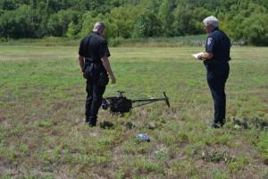
The Federal Aviation Administration (FAA) has given the Arlington (Texas) Police Department permission to use two small helicopter UAVs. The FAA did lay out a set of rules for the police department to follow when using the drones.
Arlington police test UAV in a designated testing area // Source: ozzmoe.com
Gizmagreports that the drones must be flown in the daytime, under 400 feet, in sight of the operator at all times, and a safety observer must be in contact with the control tower at Dallas-Fort Worth airport.
The drone being used by the department is the Leptron Avenger, designed by Leptron Industrial Helicopters. The drone is about five feet long and can stay in the air for about an hour. The Arlington Police originally purchased the drone with a DHS grant to provide extra security during the Super Bowl held at Cowboys Stadium in 2011.
According to Sergeant Christopher Cook, a representative of the Arlington Police department, the drones will only be used in situations in which a traditional manned helicopter would be used, and the drones will not be used for police pursuits or traffic enforcement. The drone could be used to take crime scene photos from above or in the search for a missing person.
“We basically have permission to operate our small helicopter program in certain areas of the City, generally south of Interstate Highway 30, once a clearly defined incident perimeter has been established,” Gizmag quotes Sergeant Cook to say. “We are working with our local airports which have airspace within the confines of the City of Arlington to create letters of agreement so there will be a seamless transition once a decision is made to deploy the equipment.”
More than eighty police departments around the country have applied to the FAA for permission to fly drones. Lawmakers in many are debating the issue of drone use by the police, with privacy rights organizations calling for state legislatures to impose restrictions on drone use.
Drones can be used for surveillance purposes, , and can also be used in search and rescue missions, to determine the severity of a fire, as well as search for missing or kidnapped people in heavily wooded areas. Drone are currently being used by scientists to get a better look at natural disasters such as tornados and hurricanes.
Posted by Rob_Lefebvre on March 22, 2013 at 6:00am
I just ran across this this morning on Engadget, Wired online. It immediately struck me as almost a "holy grail" of tablets to use for a ground control station. It has plenty of buttons, and 2 joysticks. We already have the excellent Andropilot app. Now we have built in controls... Maybe we should pool some money to send one of these to Kevin Hester.
The only problem is the specs are a little lightweight:
- 7" 1024x600 display, no mention of brightness
- Android 4.1 Jellybean
- Arm Coretex A9 dual-core 1.6 GHz
- 8GB Flash, 1GB Ram, with a microSD card slot
The really good news is it's only $170. It's definitely worth experimenting with.
I'd kick in $20 to send one to Kevin Hester if he's interested in developing it for AndroPilot use. Anybody else?