All Posts (14049)

Sort by

Project 'Volare' on Kickstarter

3689502714?profile=originalThrough my K1ckstarter for Kickstarter app on Google Play I ran into project Volare.

The goal of Volare is to build an autonomous plane to be able to complete 200 mile(100miles each way) round-trip journey. We plan to build it big and strong enough to be able to carry a 5lb package and be able to drop it at the destination on its round-trip journey.

I backed the project and hope others will follow!

Read more…

1st autonomous 3km mission and some details on the plane

Here is the tlog for my first autonomous 3km mission, some pics of the plane and the hardware i'm using:

2013-02-10%2009-36-48%20-%203k%20mission.tlog

The GCS:

3689502760?profile=original

The plane: Falcon

3689502783?profile=original

Hardware:

Plane

Crius AIO Pro

GPS

Telemetry

OSD

Voltage & Current Sensor

Air speed sensor

5.8G 400mW video transmitter

5.8G Video receiver

Software:

ArduPlaneNG2xR5 - Sir alex

Read more…
Moderator

Chris Anderson at AMA Expo 2013

Why I Quit my Job as Editor of Wired Magazine Chapter 1 of 5

The Opportunity to Make Military Drone Technology Available at Toy Prices - Chapter 2 of 5

The Open Source Web Innovation Model Applied to Manufacturing - Chapter 3 of 5

What We Learned from Creating DIY Drones and 3D Robotics - Chapter 4 of 5

The Bottom-Up Approach for Creating Personal Drones - Chapter 5 of 5

AMA Member Chris Anderson Q&A

Read more…

USAV - Telemetry system

USAV is the Unmanned Social Arial Vehicle - A drone with an android based auto pilot system that communicates through Google talk and Twitter. Due to the weather and the fact that an H-frame is being built for the vehicle, no flying is possible here. But I'm making good use of the wait :)

So snow is still falling here in the north and it's not really flying weather.

So I decided to make good of the waiting and create a telemetry unit for the USAV.

I guess telemetry is what Tabasco sauce is for omelets. So of course the USAV should have this kind of thing as well. Since the USAV uses the internet for communication, getting telemetry from the vehicle is a bit tricky. 

Normally, the XMPP protocol is used to talk to the craft and get info back, but this isn't really suitable for near to realtime telemetry. In stead i decided to use standard http, but getting data from the onboard cell phone is not easy since the phone as such has no public static IP address when using various cell towers to communicate.

So I created a middleware solution, where the USAV broadcasts it's telemetry to a webservice, and where clients can then get the telemetry from using another webservice. The middleware component has to have a static IP, but offers some nice features in return.

The middleware dosen't just broadcast the telemety to anyone who's interested - it also stores each telemetry packet in a database for later analysis. This way, a telemetry client is not limited to only getting the current telemetry, but also fetch older data either as a single snapshot or a series for playback of events.

The system looks somewhat like this

3689502640?profile=original

In the video below you'll see a short demonstration using a very primitive telemetry client - what you see is;

1. The USAV becomes online on the Google talk network

2. The telemetry client is started

3. Telemetry broadcasting is started on the USAV

4. Telemetry is received

5. GPS lock is achieved

6. The craft is turned 360 degrees

The telemetry unit onboard the craft is very loosely coupled, meaning that any data can be transmitted as telemetry data, using a single line of code for each and does not have to be initialized from the beginning.  

The rate of updates from the craft is configurable and currently set to once every second.

Instead of using this ugly command line based client (seen in the video), one could build a nice app, web or native gui to display the data in a nice way.

I really do hope I get to fly with this thing soon, so I can post some flight videos with the whole setup running.

Until then - all the best.

Jesper

Read more…

UxV-CS development update

ovrv.pngThanks to a friendly influenza virus, I was down a couple of days, but now, work continues. Shown in the picture is the (yet incomplete) overview page which is the first active page after switching the system on. Obviously, there are still a few empty fields in which I was planning to put some data from the FrSky telemetry but I am interested in feedback! What do YOU think about the current "overview" layout? What data do you think are important to have at a glance?

Also in the picture is an explanation of the current development of the status bar. You have probably seen it already in the videos and were wondering what all those little indicators mean :).

Read more…

Introducing OpenGSU : Cross-Platform Ground Station

3689502509?profile=original

I'm following this community regularly and I must say that I'm very impressed
by all the job done and the good spirit. Congrats to Chris and all the team players!

Some months ago, I started to build a ground station and I realised that
an affordable full-featured ground station with video + data link, antenna tracker,
a good visual way to get some status, in a small shape was not available.

Almost all the features needed their own independant device that need casing, wiring, source
of power, all kind of adaptation, settings to make stuff talking together, dealing with differents
suppliers to finally getting a big heavy mess of wires, connectors, pcbs and boxes.

Then I finally decided to design my own all-in-one integrated solution. So what seemed a simple
step in turning my heli into an UAV turned to a complete project : OpenGSU.

3689502560?profile=original

OpenGSU stands for open source ground station unit and the project aims to simplify ground
station building and to provide a rich set of features with the flexibility of open source software.

Today, the opportunity to share my work is sounding great to me, and this is probably due to the
influence of Diydrones sharing spirit.


Here the OpenGSU features list, some are already well running and some are in progress:

- 5.8Ghz Video receiver with two buffered A/V outputs
    - one outputted through an 4-poles jack connector for an LCD, googles or video recorder...
    - one internally connected to an USB video capture allowing the PC getting the video
- Xbee footprint compatible transeiver with independant LDO
- Standalone GCS on color touchscreen feeded by MAVLINK frames
- Standalone SDCard datalogger with real-timestamp (RTC is integrated)
- Standalone Joystick controller allowing control through a regular usb joystick  
- Standalone configurable buzzer-alarm (low battery, signal lost, maximum altitude exceeded ... )
- Standalone Sensorless Antenna tracker based on the data downlink
- 32-bit dev-board allowing execution of custom code
- PC connexion using an unique USB wire allowing (HUB is integrated) :
    - Video link (USB video capture device),
    - Data link (Virtual Com port),
    - Log access (Mass storage device)
    - MCU Firmware update (USB HID bootloader)
    - Compatibility with the well-known GCS : Mission planner and QgroundControl
- Possibility to power from USB only but with some components automatically inhibited.
- 5amp DC/DC with 6-32V voltage input to handle big tracker servos
- Aluminium compact casing or "OEM" version for pelican case machined panel integration

3689502535?profile=original                        Open GSU back panel

3689502546?profile=original

                       Open GSU PCB bottom view

3689502587?profile=original

                        Open GSU PCB Top view

I'm working currently on a website and it will be online soon.

More details will follow in my next posts.

Meanwhile, Feel free to show your interest.

Mohcine

Read more…

AUAV3 is comming!

3689502623?profile=originalHi guys,


Phillip Kocmoud and I are proud to announce the third generation open source, MatrixPilot based flight controller – AUAV3. We will also be releasing concurrently an external power supply / current and voltage sensor board - ACSP1. The initial batch for development and testing will be ready in a week or two. We expect to be shipping these out on or before March 1st from both the US and European locations.

Some of the AUAV3 features:

*     MCU – dsPIC33EP512MU810
*     Onboard 32Mb Flash AT45DB321
*     Onboard IMU – MPU6000
*     Onboard compass – HMC5883
*     Onboard absolute pressure sensor – BMP180
*     Onboard CAN – MAX3051
*     Two opto-isolated UARTs – for OSD and Telemetry
*     One non-isolated UART
*     One I2C and one SPI user interfaces
*     8xRC inputs, 8 servo outputs
*     RSSI input
*     USB
*     4 x Analog inputs
*     3 x Digital I/Os
*     Universal GPS 4pin 2.54 connector
*     ICSP 5pin connector
*     4 x LEDs red, blue, green and yellow

Onboard Power supply

*     Main power – external 5V
*     Onboard 3.3V 1A LDO regulator
*     Optional BackUp power – 1xLi-Po or 4xNiMH or other 5V
*     ESC powering capability
*     Preferable power supply – ACSP1 ( Current/Voltage sensor board + 5V3A DC-DC Buck )

Dimensions and additional extras

*     Dimensions – 45 x 35mm
*     Two types of connectors – 2 x 3row x 14pin 2.54mm right angled or separate straight color coded connectors
*     USB port for future use – programming, etc.
*     CAN interface with driver MAX3051
*     ESD protection on I2C, USB and SPI
*     Reverse power polarity protection by power MOSFET

The documentation will be posted here and on www.arsovtech.com in a few days.

To have the AUAV3 complete solution you will require the ACSP1 – current voltage sensor + DC-DC 5V 3A Buck power supply or alternative one.

3689502676?profile=originalSome of the ACSP1 features:

*     Dimensions – 30 x 26mm
*     Onboard Current and Voltage sensor
*     Onboard 90A alloy shunt
*     Onboard 5V 3A 1MHz DC-DC Buck
*     90A current capability
*     2-4 Li-Po ( up to 20V )       
*     A heat shrinkable tube for board protection
*     22AWG x 4 + 2.54mm 1x4 connector for powering the AUAV3

Phil and I are pleased to announce the prices of AUAV3 and ACSP1, as follow:

* AUAV3 - $129.95
* ACSP1 - $24.95
* Preorders / Promotion - AUAV3+ACSP1 - $129.95 + free shipping

Promotion and preorders will start Feb 18, 2013 and run till March 31, 2013 at www.arsovtech.com (Wordwide) and www.auav.co (North America).
Orders over $50.00 will have free shipping.
Initial quantities are limited and will be fulfilled on a first come first serve basis.

Let the fun begin!

Regards from Nick Arsov and Phill Kocmoud

Read more…
3D Robotics

3689502458?profile=original

From Farmers Weekly in the UK. Rounding up livestock, detecting blackgrass weeds and more!


Engineers at Harper Adams University have teamed up with Chinese researchers to develop a fleet of ground-based robots and unmanned aerial vehicles that benefit farmers.

Jobs undertaken by robots could include locating and rounding up livestock in remote areas, precision application of fertiliser and the integration of controlled traffic farming.

Simon Blackmore, head of engineering at Harper Adams, said unmanned aerial vehicles or drones fitted with cameras could also be used by agronomists instead of crop walking.

The government-backed project has seen Harper Adams University awarded £36,000 to further collaboration between the two countries.

The partnership will link the research with the Engineering Departments of Harper Adams and China Agricultural University, focusing on developments in precision agriculture.

AdTech Ad

Both universities are researching precision farming technologies.

The project aims to develop the protocols and controls required to operate a mixed fleet of robot agricultural vehicles capable of a diverse range of farming tasks.
In a separate move, next month's Precision Farming Event at the East of England Showground will see the launch of a commercial company offering drone technology to farmers.A special exchange programme will see three members of staff and three PhD students from Harper Adams visit China during the next two years, while their counterparts visit the UK.

Unmanned aerial vehicles are already being successfully used to detect blackgrass in arable crops, said Mark Jarman, of Ursula Agriculture.

The vehicles fly at about 1,000ft and can cover 150-250ha in a 30-minute flight - much faster than an crop-walking agronomist.


Read more…
3D Robotics

"Letting Drones Reach Their Potential"

3689502395?profile=originalSomehow I missed this excellent op-ed by Ryan Calo when it came out in December:

Letting Drones Reach their Potential

Why the potential uses of drones for good are endless and should be protected

Ryan Calo | December 12, 2012

I have three concerns regarding the domestic use of drones.  The first is that drones will facilitate massive surveillance by the government.  The second is that private parties will use drones to harass one another.  The third is that, precisely because of their readily imagined capacity for privacy mischief, the transformative potential of drones will never be realized.

This third concern – the concern for the drones themselves – may be the most pressing.  The prospect of military-grade drones on the home front is certainly chilling, but the present reality is that police departments cannot afford cutting-edge technology.  The drones owned by, for instance, the City of Seattle, where I live, can only stay up in the air for a short time.  It turns out to be hard to oppress in 10-minute increments (law firm billing notwithstanding).  This is not to deny that officers could put today’s drones to questionable use, borrow drones from the federal government, or upgrade their technology over time.  But for now, opportunities for constitutionally offensive conduct are relatively limited.

Similarly, many may recoil at the prospect of flying cameras in the hands of teenagers or paparazzi.  No bathroom window or backyard would be safe.  Those already uncomfortable with Google’s Street View technology might not welcome a less vertically challenged update.  Yet, the Federal Aviation Administration (FAA) – the American agency that Congress recently charged with expanding drone use in the United States – is not supposed to relax restrictions on private use until at least the fall of 2015.  This gives us a few years of breathing room.

In contrast, the danger that citizen backlash will ground drones is immediate.  As I’ve argued elsewhere, drones constitute an atypically visceral and salient example of surveillance technology.  People in the West are nervous about robots in general.  We find the specific act of drone surveillance – which many associate with the theatre of war (see “KILL”) – all too easy to imagine.  As such, drones generate intense opposition, to the point that I’ve gone on record saying that drones may help resuscitate long-dead concepts such as the reasonable expectation of privacy in public.

But think of the drones.  The potential uses of drones for good are endless (see “AID”).  The police can use drones to find the missing, improve tactical responses through better situational awareness, respond to disasters, or photograph unusual or difficult-to-access crimes scenes.  Parents are using drones to confirm their kids make it to the bus; teachers to teach physics; artists to provoke and reveal; activists to police the police; farmers to monitor and tend crops; environmentalists to catch polluters; and architectural photographers to explore new angles.  Likely, too, drones could be used for something you’ve never heard of: Perhaps the most wonderful development has been the emergence of the drone as a platform, which leaves the possibilities for applications in the millions of hands of software developers and end users. 

One might be tempted to simply tell opponents of drones to calm down.  That would be a mistake.  First, they absolutely have a point: This technology is headed in a direction that could seriously undermine civil liberties if left unchecked.  And second, no one takes well to being dismissed out of hand.  Rather, we should give in to their demands – demands, it should be noted, that are by and large very reasonable.  The FAA should acquiesce to requests from the Electronic Privacy Information Center, the chambers of Representatives Ed Markey and Joe Barton, and others, to condition issuance of licences to operate drones on responsible privacy practices.  Demonstrated privacy violations could then result in revoking the licences.  Domestic and federal law enforcement should be more transparent about existing and anticipated programs.  And police departments should commit to securing a warrant before using drones for many investigative purposes.  These, and perhaps other, reasonable conditions are a small price to pay to avoid curtailing a transformative technology of our time.

MORE FROM THIS SERIES


Read more…

NVida Shield: Controller + Groundstation Combination

Image of NVIDIA Project SHIELD

802.11n 2x2 MIMO game-speed Wi-Fi

I have been thinking quite a while now about what would make the ultimate UAV flight controller.  Reading through a CES highlight story I saw the NVidia Sheild project that basically combines an Android Jellybean touchscreen tablet with a game controller.  Of course this device is "vaporware" and is designed for gaming, but it doesn't take much of a stretch of imagination to run the Mission Planner for Android software currently under development, plugging a USB telemetry link into the port on the back, and flying/driving the UAV of choice.  Closing the lid it appears to be quite portable.  It will be interesting to see what the price will be, whether the display will be readable outdoors, and when will it be available.

See more at the web page http://shield.nvidia.com

With the advent of cheap cellphone processors I'm just surprised that the RC Transmitter manufacturers haven't made a transmitter that would be compatible with running a ground station software.  The mating of a cheap tlablet technology with RC transmitter seems like a good idea.

Read more…

3689502369?profile=original

### UPDATE @ 8:52PM, 2/9: Kévin Bouchard, robotics coordinator for Fusion Jeunesse and computer science student at Université Laval, has pledged $20 for the Nemo Drone Prize! Thank you for your help, Mr. Bouchard.


Our new total: $380. ###

### UPDATE @ 8:10PM, 2/9: Michael Shimniok of BOT-THOUGHTS.COM has kicked in $20 for the Nemo Drone Prize!


Also, amending some previous updates, as Gary Mortimer of sUASNews.com announced he is in fact contributing $120, not the $60 as listed previously. Thank you Mr. Mortimer for your assistance.

Our revised total for the contest is now $360 - much, much better than the $60 I started with. Thank you to all the generous donors who believe drones can make the world a better place. ###

### UPDATE @ 4:03PM, 2/9: Gary Mortimer of SUASNEWS.COM is contributing an extra $60 to the Nemo Drone Prize!

That puts our new prize total at $280!

Thank you to all our sponsors for making this prize possible. If you'd like to contribute to the cause, email me at mschroyer@gmail.com

For those in the affected areas, please keep in mind that the contest will end at sunset on Monday. NOAA is indicating light winds for the northeast on Sunday, and it now appears that there will be some precipitation for Monday. If you want to try to win the prize, it looks like tomorrow might be your best and only option. ###

### UPDATE @ 2:08PM, 2/9: More great news -- Adam Sloan of BIRDSEYEVIEW is contributing $100 to the Nemo Prize! That brings the total cash reward for the challenge up to $220!

In addition, Mr. Sloan is announcing that his aerial photography company, BirdsEyeView, will be donating aerial robot services FREE OF CHARGE THROUGH MONDAY. If you could use the assistance of a flying robot during this 2013 Nor'easter, email him at relief@birdseyeviewuas.com. ###

### UPDATE @11:23AM, 2/9: Great news, everyone! Walter Volkman of  MICRO AERIAL PROJECTS LLC is chipping in an additional $60 for the award. That means the total cash award for this challenge is $120!

I'd like to thank Mr. Volkman for his kind contribution to the cause. Micro Aerial Projects LLC provides aerial infrastructure and asset management, aerial mapping, post-disaster assessment, and drone journalism services (and more) courtesy of his Aibot X6 hexcopter.

Additionally, I'm now referring to this challenge as the NEMO DRONE PRIZE. It's like the X-Prize, but instead of sub-orbital spaceflight or oil cleanup, it's to put drones to use for helpful causes. ###

I'm announcing a contest: prove your drone can be useful during winter storm "Nemo," and I'll send you $60 $120 $220 $360 $380. Here's why:

"Above is a picture of a quadrotor drone, an airframe from a fixed-wing drone, and $60 $120 $220 $360 $380 cash. The money is yours if you make your drone useful during the aftermath of winter storm Nemo.

I know it's not a lot of money. It's all I can afford right now. But I'll mail it to you if you complete a task that demonstrates how useful drones can be in the event of a natural disaster.

Why? Because I believe that drones can be used for good. That's why I started DroneJournalism.org and co-founded Drones for Good.

The North East is having a weather crisis. Some call it "Nemo."

Governors in four states have ordered citizens not to use public roads. Airports are closing, and public transit is closing down in New York, Connecticut, Rhode Island, and Massachusetts. Feet of snow are supposed to fall, making it difficult for emergency crews to respond to the disaster.

You know what could help during a time like this? A drone."

Rules and details about the contest are posted on my website.

Anyone in the northeast not doing anything for the next couple of days? Well, here's something to do.

Read more…
Moderator

03ttDrones-articleLarge.jpg?width=300

Interesting legislative activity in the Lone Star State:

drone, no bigger than a toy airplane, hovered north of the Texas Capitol, floating over the heads of lawmakers who were momentarily distracted from their morning meetings. Several of them gathered beneath it, faces tilted skyward, marveling over a pair of goggles that allowed them to watch live video of the craft’s panoramic bird’s-eye view.

But when the conversation turned to the reason for the demonstration, the tone shifted. Representative Lance Gooden, Republican of Terrell, said he was sponsoring legislation to prevent this futuristic technology — increasingly used by everyone from aviation hobbyists to law enforcement authorities — from capturing “indiscriminate surveillance.”

http://www.nytimes.com/2013/02/03/us/lawmakers-aim-to-limit-drones-and-safeguard-privacy.html?_r=0

http://radio.woai.com/cc-common/mainheadlines3.html?feed=119078&article=10784277

Of particular interest to our community:

“It will be a greater burden on the hobbyists, but I think that’s O.K.,” Mr. Gooden said. “If you’re asking me to choose between my right to privacy and a hobbyist’s right to take pictures from the sky, my privacy comes first.”

and a counterpoint:

“If I’m using it to continuously monitor somebody, I think we could make a law that would forbid such a thing,” Dr. Humphreys said. “But if I’m up there doing some other benign research and happen to capture your picture inadvertently, I don’t think ought to be outlawed.”

And as an administrative note, Chris has created a forum for talking about government drone regulations.

http://diydrones.com/forum/categories/regulation/listForCategory

Read more…
Moderator

3689502333?profile=original

Gene Robinson's work with RP Search Services has been covered here before, but there's a nice news story with write-up here.  Gene emphasizes the positive use of "unmanned aircraft" (as he prefers to call them), and how he hopes that flight permission will be easier to come by.

http://www.myfoxaustin.com/story/21079431/drones-saving-lives-thanks-to-central-texas-non-profit

Read more…
Moderator

3689502316?profile=original


In the last months on the market appear a lot of low cost micro quad , they are very nice toys i like a lot play with it . But the main problem is that the standard electronic is not hackable and i cannot use my radio for control the quad. So i decide to evaluate if was possible interface a quad toy frame with my VRBRAIN.

  • The main tets that i doing was the payload and discover that was possible to going in air with a payload of 100 gr. VRBrain in Naked configuration is only 21 gr
  • The other problem was how i can manage the motors ? So i doing a bit of retro eng and discover the electronic need to my vrbrain for control the dc motors. I don't use esc for interface the motors of quad 
  • After solve the electronic problem i start to check the patch to firmware and found how can change the pwm parameter for control the dc motors.
  • Other problem was the battery , normally the quad toys use a 1s battery but the standard input voltage is 5volt. So i check the schematics of vrbrain and found a 3volt input , put on the 1s battery a small 3.3volt stabilizer and put the output on the gps output 3.3v .
  • After last patch i thought that i'm ready for first fly , but last things  was the radio ... fortunately my Jeti receiver work also at 3.3volt  so it work , i have only a signal on my radio about low level voltage ... :(


3689502240?profile=original


The final result was this : I'm happy to present VR Pico Drones , basically it use standard arducopter32 2.9 on my VRBRAIN and support all standard functionality available in arducopter , stable , acro , loiter , rtl and auto navigation . So this is smallest Arducopter drone available on the planet :) This is only first prototype the wheight is 110 gr. My idea is to doing some optimization on board and have a 85 gr drone capable of 10 minutes of funny fly.


3689502296?profile=original


After some days of hard work this is my first fly test . I'm very happy of this first results :) The main target of this development is to use VRBRAIN for learning to fly during winter days in indoor. I play a lot with simulator but fly with a real copter is better. (sorry for audio , is in italian , the next will be in english :)


Original blog post:

http://www.virtualrobotix.com/profiles/blogs/is-possible-to-control-a-quad-toy-motors-by-vrbrain-first-test-of

Read more…
3D Robotics

Having fun with FollowMe

On a super windy day at the Berkeley Marina, we demoed the ArduCopter FollowMe function (which is built in to the Mission Planner). That's me walking around with a laptop (with a $27 USB GPS dongle), and the copter follows me around like a pet robot bird. Then at the end I tell it to land itself, which it does. 

Note that there's no RC control at all. This is all autonomous flight, with mission command issued with a point-and-click interface on a laptop. And in some serious wind, too!

Read more…
3D Robotics

Using drones to track elephants

3689502148?profile=originalFrom the scientific journal PLOS One:

The use of a UAS (Unmanned Aircraft System) was tested to survey large mammals in the Nazinga Game Ranch in the south of Burkina Faso. The Gatewing ×100™ equipped with a Ricoh GR III camera was used to test animal reaction as the UAS passed, and visibility on the images. No reaction was recorded as the UAS passed at a height of 100 m. Observations, made on a set of more than 7000 images, revealed that only elephants (Loxodonta africana) were easily visible while medium and small sized mammals were not. The easy observation of elephants allows experts to enumerate them on images acquired at a height of 100 m. We, therefore, implemented an aerial strip sample count along transects used for the annual wildlife foot count. A total of 34 elephants were recorded on 4 transects, each overflown twice. The elephant density was estimated at 2.47 elephants/km2 with a coefficient of variation (CV%) of 36.10%. The main drawback of our UAS was its low autonomy (45 min). Increased endurance of small UAS is required to replace manned aircraft survey of large areas (about 1000 km of transect per day vs 40 km for our UAS). The monitoring strategy should be adapted according to the sampling plan. Also, the UAS is as expensive as a second-hand light aircraft. However the logistic and flight implementation are easier, the running costs are lower and its use is safer. Technological evolution will make civil UAS more efficient, allowing them to compete with light aircraft for aerial wildlife surveys.

Read more here

3689502222?profile=original

(hat tip to Paul Kedrosky)

Read more…
3D Robotics

Kickstarter project for a "Smart-Pod" UAV pod

I hadn't noticed this on Kickstarter before, and it appears nobody else did, either -- with just 60 hours to go they've raised less than $1,000 towards an $180,000 goal. (Maybe they should have posted on it here!).  But it's an interesting idea -- just a UAV "pod" with the autopilot and camera, that you could add to any aircraft. It uses APM and a GoPro. 

Perhaps one of the reasons it didn't get many backers was the pricing: $1,500 for what appears to be less than $500 worth of parts (APM + 3DR radios + GoPro). 

Here's the Kickstarter listing:

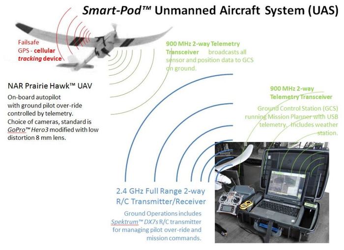
Smart-Pod™ is the core of a work-horse miniature Unmanned Aerial Vehicle (UAV) system.  It elegantly combines a custom-fit mission pod (autopilot, avionics, instruments, cameras, etc.) with a ruggedized R/C aircraft making the UAV more affordableeasier to fly, safer to operate, and more practical to support.  Coupled with a formalized UAV Pilot Training Program it represents a 'smart' way to enter the UAV field. 

(note - the above video shows our North American Robotics' 'Prairie Hawk' Smart-Pod-enabled UAV on its 85th mission, all with no damage, regardless of landings on asphalt, dirt roads, tilled farm fields, harvested corn fields, and both short and long prairie grasses.  None posed any particular concern to the aircraft landing.) 

* If the idea of operating a UAV has appealed to you - then you will welcome our practical approach and unique products.

* If you have been concerned that learning to operate a UAV is difficult - know that we designed our UAVs specifically to be well-behaved enough for the novice, but capable enough for the advanced UAV operator.  We planned for someone who has never flown an R/C aircraft, nor gathered any aerial photography, as well as operators who need extensibility and flexibility.  We integrated compehensive Ground School with an accurate UAV flight simulator and series of real world training missions to introduce the pilot to the flight characteristics of our UAVs, and to develop their skills. This approach works.  If you're considering an entry in to UAVs - this will be and ideal start.  If you are already confident that you know what you need, this will perform dependably season after season. 

* If you have been worried about the dangers involved in UAVs -we make safety the watchword in operating a UAV/UAS.  Our Smart-Pod's "soft" materials and light weight minimize its potential to cause damage, and its special design makes pod-enabled UAVs much easier to fly and land safely than a typical R/C aircraft.

* If you have been discouraged by the start-up costs associated with the few non-toy UAVs that are available - you will see the wisdom we used to keep start-up, operating, and maintenace costs low and manageable. 

* If you want a Sci-Fi "drone" that flies itself and does all its own thinking - be prepared, you are pretty much what the FAA is working toprevent.   UAV operation needs to be done with forethought, and with consideration of both public safety and individual privacy.  Our line of UAVs is capable of nearly complete automated flight from launch to recovery, but the FAA discourages this.  Our strategy is to blend human pilot management with the automated flight.  We designed our approach to provide pitch and roll stabilization at all times making human control of the UAV smooth and unintimidating, with instant access to pre-programmed flight patterns to make complex missions easy to execute.  Our system provides the UAV pilot with immediate over-ride at all times.  This promotes the safest and most responsible of UAV operations. 

What is a UAV/UAS? 

An Unmanned Aerial Vehicle (UAV) is an aircraft, often a fixed-wing airplane, which can operate under its own control or under the control of a remote human pilot.  A miniature UAV (MAV) is much smaller than a conventional airplane, and can be deployed close to where it is needed; often hand-launched and recovered.  It can bring aloft cameras and other specialized sensors to gather aerial imagery, special infrared (IR) imagery, or atmospheric weather data.  An Unmanned Aircraft System (UAS) includes the UAV and a Ground Control Station (GCS) of some form, along with a telemetry communication channel between the pilot, the UAV, and the GCS. 


Who needs miniature UAVs and why?

A birds-eye view has always been valuable for inspecting property, managing resources, advertising and sharing a large-scale events (like outdoor celebrations or sports), and supporting scientific studies of a large or inaccessible area.  Historically, this was accomplished by a hiring a private pilot and airplane, as well as a photographic crew, and securing a special permit to fly where the desired images could be gathered.  This has beenextremely expensive, and severely limited what applications could afford it. 

With a robust miniature UAV, a wide range of applications can be explored with comparatively affordable costs.  North American Robotics (NAR) has been developing UAVs with special cameras and sensors for scientific environmental research projects, precision agriculture and improved farm production, real estate property inspection, municipal site management, and emergency response search support.  Our goal is to make these rugged UAVs available as practical tools – the kind users can depend upon to perform, and afford to actually operate. 

A different approach than other miniature UAVs

Many reputable groups and organizations are working to provide UAVs to the industries wanting to experiment with them, but the products available represent either wildly expensive ultra-high-end defense department type UASs or park-flyer near-toys, leaving the practical, “work-horse” of UAVs only to the do-it-yourself-ers.  If UAVs, especially miniature UAVs, are to get into the hands of regular people interested in developing new applications and new industry, then a product line needs to be provided that is affordable, rugged, tailor-able, safe, and most importantly – supportable. 

To be rugged, a UAV needs to protect the autopilot avionics, instruments, and sensors - making certain they can operate effectively and that they are secure throughout the mission, from transport, to deployment and launch, through to landing and recovery. 

To be supportable the UAV needs to be serviceable and ready any time the weather permits safe operations".  This is very difficult if a UAV is so unique there is only one vendor to support it, and only one place from which to get spare and replacement parts.  That means stepping back away from designing yet another unique special-purpose limited-availability aircraft andinadvertently becoming the very bottle neck of parts and support that hold back application development

What has been missing is a capable and robust manner of bringing popular airframes and the autopilot electronics together to make a “pick-up truck” UAV, a FORD F-150* of the miniature UAV industry.  At North American Robotics we have done just that by following a proven approach that has been employed by the U.S. Air Force, NASA, and our own DOE R&D for decades - an air-borne mission pod

(*FORD F-150 is a registered trademark of FORD MOTOR COMPANY.  Its use here is intended as a compliment to their product line, but does not imply endorsement or support from FORD for this project)

In the mission pod approach, all of the costly and vulnerable avionics, sensors, flight control instrumentation, and telemetry electronics are carried in an aerodynamic, ruggedized, crash-survivable pod slung beneath the aircraft’s hull or fuselage.  Furthermore, the pod is designed to be the landing gear of the UAV.  The airframe is left virtually unchanged, while the mission pod mounting is designed to not interfere with the aircraft center of gravity (CG) or any other flying characteristics.  The demonstration aircraft chosen have been capable and popular R/C aircraft, with a wealth of replacement parts and options readily available.  The example instruments (cameras and sensors) include popular series sport cameras with optional mission-tailored lenses and weatherproof impact-resistant polycarbonate cases.   

We call our approach the "Smart-Pod" Modular UAV, because it is the "smarts" of the UAV.   It is also a smart approach to building a practical UAV. 

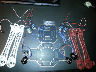
The early Smart-Pods looked like this - a solid block of high-impact EVA foam with cavities machined in to exactly fit the autopilot and other avionics that get housed inside.   

The Smart-Pod is attached to the strongest areas of the host aircraft to create the rugged UAV.   It is shaped to be aerodynamic, and to serve as an effective landing sled to protect the instruments and the aircraft. 

The final cost of our turn-key Smart-Pod UAV is a fraction of the $15K-$20K cost of comparable mini-UAVs on the commercial market today. 

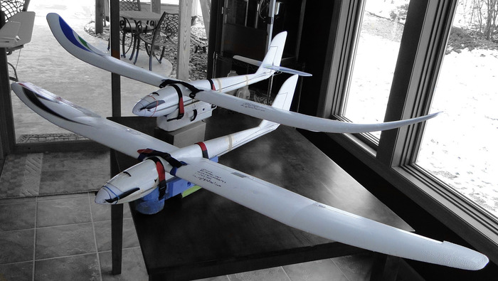
We've already constructed six (6) prototypes of the full 2-meter wingspanPrairie Hawk and Prairie Hawk Pro Smart-Pod UAVs, using three (3) different commercial R/C electric powered gliders.  We flight tested them in over 100 sorties (launch/fly mission/recovery) and developed a method to strengthen and ruggedize individual components.  In our UAV prototypes the mission pod configuration both improved the flight stability of the aircraft as a sensing/camera platform, and dramatically increased the UAV's ability to land without injury in unimproved field conditions.  It made all the test aircraft significantly easier to fly in both autopilot and in manual modes. 

Smart-Pod simple integration to aircraftSmart-Pod simple integration to aircraft
Smart-Pod in operating positionSmart-Pod in operating position


Video of Smart-Pod UAV

We have made the Smart-Pod UAV part of a complete organization of service, training, and support for individuals and groups deploying and operating miniature UAVs for academic, agricultural, industrial, municipal, and commercial applications.  (See video above and more on YouTube.comhttp://youtu.be/lPNOSuqMYTQ

http://youtu.be/K6eAPm3VMxY

http://youtu.be/NEtDgU3K7-Q

http://youtu.be/QoDq8EnVIB4

http://youtu.be/GHg-cgXxI8c

http://youtu.be/1LPW7b9hTcg

)

Smart-Pod design approach

We have introduced miniature UAVs into our research involving atmospheric emissions monitoring, aerial pipeline inspection, and ground vegetation damage analysis.  For our applications we've operated from all types of terrain – plowed farm fields, unimproved roadways, military tank training grounds, rural prairies, and hard-packed deserts.  None of our field sites included a nicely mowed thick carpet of soft grass in a city park.  Because of this, we had two primary design criteria: 

·         the UAV needed to deliver the desired electronics and payload over the region of interest long enough to gather the data needed, and

·         the UAV needed to be easy to launch and rugged enough to land on any terrain, and also easy to repair if and when some damage occurred. 

“Safety” was a major concern, both to the aircraft instruments and to the people and property on the ground below where the UAV would be flown.  These practical criteria led us to the adoption of existing, popularExpanded Polyolefin (EPO) and Expanded Polypropylene (EPP) R/C airframes and the use of light and durable Ethylene-Vinyl Acetate (EVA) foam for the mission instrument pod.  These two materials were substantially unaffected by any weather conditions, retained their shape and strength throughout a wide range of ambient temperatures, remained easy to machine and work with, and would cause minimal damage during a crash. 

Each component of the commercial airframes was “ruggedized” to increase its strength and resistance to abrasion expected during belly landings at unimproved fields.  Each of these modifications allowed the component and the airframe to bear more load weight and flight stress and endure more punishment – all vital to a practical work-horse UAV.  It was not however “required” for UAV flight and operations under normal condition and the aircraft can be flown with virtually un-modified commercial parts to prevent being grounded during an important mission.  It simply performs better and safer with the ruggedized components. 

We selected a motor and ESC that had braking capability, coupled with a folding plastic propeller that would minimize any injury danger. 

We enveloped our Li-Po batteries with a light-weight fire retardant material to protect the airframe and the surrounding ground covering and property from fire in the [unlikely] event of a hard crash. 

Smart-Pod advantages

By separating the autopilot electronics and camera/sensor instruments from the hull/fuselage, and enclosing them in a container specifically designed to protect them, then the largest expense in fielding an UAV was also made the most safe and most durable. 

By making the pod easy to add to any suitable aircraft available the plane actually becomes expendable, and even in the event of a complete catastrophic crash, could be replaced with a trip to the local well-supplied hobby store putting the mission back on track in a matter of hours. 

The pod design itself can be tailored to fit and deploy a wide range of commercial cameras and experimental instruments – contact NAR and discuss this important advantage. 

Replacements for any vulnerable parts can be carried along, but are often repairable in the field with supplies available from local hardware stores. 

NAR supports and promotes the open-source ArduPilot Mega (APM) autopilot and Mission Planner Ground Control Station (GCS), which together allow visual graphical planning of complex flight missions directly on a photographic map.  NAR modifies both the autopilot to tailor it to the airframe, and the Mission Planner to make it easier to use. 

NAR Prairie Hawk and Prairie Hawk Pro turn-key UAVsNAR Prairie Hawk and Prairie Hawk Pro turn-key UAVs
NAR Ground Control Station - in Pelican case w DX7s TxNAR Ground Control Station - in Pelican case w DX7s Tx

The GCS with the Mission Planner allow the UAV Pilot to visually plan the AUTOmated segment of their flight.  This is done in a point-and-click fashion placing waypoints (WPs) on a satellite map displayed in the Mission Planner.  The mission is uploaded to the UAV and assigned to a programmable switch on the DX7s Transmitter.  During the flight, the Pilot only has to press the switch to initiate the automated mission.   Here is an example of a trivial training mission with 3 WPs and Return To Launch where the UAV circles until the Pilot takes control and lands. 

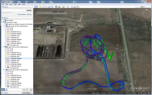
After the flight, the Mission Planner allows the Pilot to examine the Flight Data Log and chart the course as-flown in GoogleEarth. Here, the mission can be inspected to determine its accuracy and improve planning for future missions.

The U.S. Federal Aviation Administration (FAA) govern the U.S. air space.  They are still writing all the new policies concerning operation of UAVs in the U.S. air space.  An important aspect of their current regs is having two people, a pilot and co-pilot, both operating the UAV.  Our approach makes the most of this by allowing the two operators to work together.  The pilot is in control of the Transmitter and flies the UAV in traditional R/C fashion, triggering pre-programmed flight modes as needed.  The co-pilot operates the GCS, and via the telemetry, sees a virtual dashboard with flight instruments and can track the UAV real-time on the displayed map.  BOTH can control/over-ride the UAV with complementary controls.  It is a system that allows either one to operate, and for simpler missions the Pilot with Transmitter can operate the UAV alone. 

The launching and recovery of our UAVs has been made as easy and predictable as possible, and will allow the Pilot to focus on the purpose of their mission.

If the mission is simple aerial photography, it can be gathered using look-forward, look-sidesways, or look-down versions of the pod - whichever is needed for the mission.

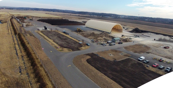
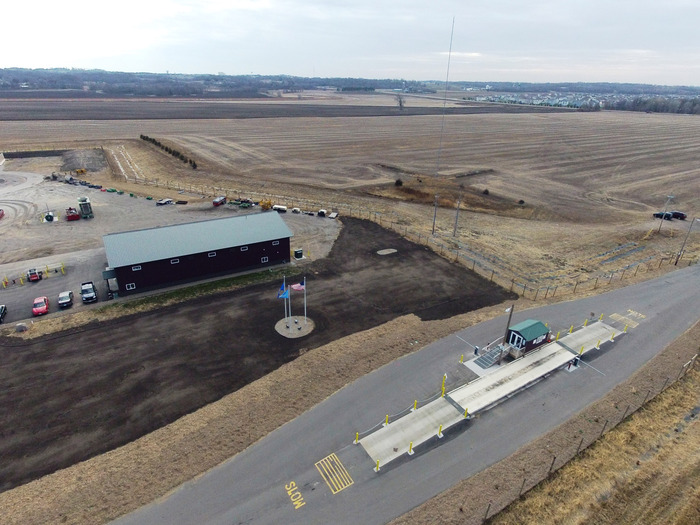
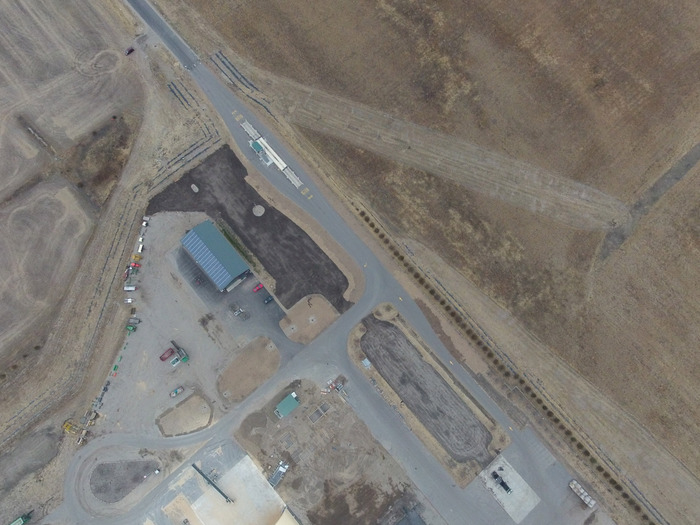
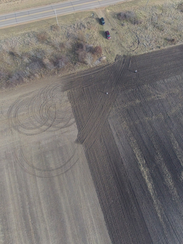
Below is a satellite photo of our testing grounds - all other images were captured from our UAVs at different altitudes over this test ground.  The RED and YELLOW circles illustrate the precision we are capable of - maintaining and repeating a circular path many times for close area surveillance. 

The above image... zoomed in with as-flown flight path overlaid.  . 

An example shot from approx. 200 m Above Ground Level (AGL) produces approximately 10 cm/pixel ground resolution - this is routine.

Oblique photos taken during LOITER around this site. 

For these images, the UAV was pointed into the prevailing 20 mph head wind and allowed to 'station' itself over a fixed point on the ground.  It can do this with or without the motor operating. 

A quick inspection of the chase vehicle... and pilots on the ground. 

The following is a description of the North American Robotics UAV/UAS equipment you can receive.

The Smart-Pod Mission Pod. This is the core component upon which we build the UAV and the UAS.  This rugged pod houses the autopilot, avionics, sensors, and camera.  We have intentionally test-crashed this from over 100 ft altitudes crashing at 30 mph and destroyed aircraft, but protected all internal instruments.

The Prairie Hawk and Prairie Hawk Pro UAVs.  These start as commercial R/C powered gliders, but become work-horse UAVs after some ruggedizing and the attachment of the Smart-Pod with the avionics.  The Smart-Pod stabilizes the aircraft making it extremely easy to launch, fly, and recover - often with no more pilot control than speed and steering. 

The Ground Control Station can be any of a variety of notebook PCs, brought to the field in a ruggedized Pelican case.  The GCS communicates with the UAV through the [XBee or non-XBee brand] 900 MHz transceivers.  All flight data is thus recorded on the GCS using the Mission Planner.  The Mission Planner is software running on the GCS.   Inside the Mission Planner the UAV pilot can see a satellite map or drawing of the area they plan to fly.  They plan a mission by placing Way Points on the map and assigning step by step actions to execute (such as 'loiter' around in a fixed diameter circle at a fixed height for a fixed period of time)  typically ending with Return to Launch place. 

The Transmitter we prefer is the Spektrum DX7s or DX8.  This is the over-riding control between the UAV Pilot and the GCS/UAV.  The switches on the Transmitter will be pre-programmed, and allow the UAV Pilot to switch between Flight Modes.  With the flipping of a switch the UAV Pilot can make the UAV loiter or simply fly in a circle above his or her head (taking pictures).  With the flipping of another switch, the UAV will come home from wherever it is, and with the switching of another switch the UAV will execute a pre-planned mission, much like turning on a cruise control on a car.  When the pre-planned mission is complete, the UAV returns home, where the UAV Pilot can bring it in for landing. 

The Smart-Pod makes the UAV much much easier to land than a normal R/C plane.  Most of our landings are "hands-off" with the autopilot stabilizing the UAV, all the propeller power off in a full glide, and the pilot only responsible to steer left and right.  The Smart-Pod provides a firm strong surface on which to land and protects the UAV from all but the most poorly executed landings.  We configure our UAVs to land themselves if a failsafe is triggered. 

We have done the work in configuring and tuning the aircraft, but each UAV Pilot must still accept responsibility for all of their aircraft's actions.   The FAA also recommends flying UAVs in pairs with a Pilot and Co-Pilot both in control of the UAV. 

Links to many more videos and images will be available very shortly on the updated North American Robotics website.

Read more…

Shunned technologies from the past

3689502128?profile=originalMachine Trashing (1812)

I've been doing some research on the history of technologies that, in spite of their benefits, have been misunderstood or vilified. 

A search for "shunned technology" turned up this interesting story -- about the zipper's struggle to find a place in the market during the early twentieth century:

http://www.csmonitor.com/Innovation/Pioneers/2012/0424/Gideon-Sundback-At-first-the-world-shunned-the-zipper

Some excerpts --

"Despite the devices attributes, the public was not receptive," writes fashion historian Ronald Knoth. "The pulpit decried, 'The Hookless Fastener' as 'the Devils fingers,' [because it made it easier] to remove clothing with autonomy.

...

The US Army used Sundback's interlocking teeth for gear and clothing, but zipper didn't take off in civilian clothing until 1923, when B. F. Goodrich Company wanted to innovate on the standard boot. It introduced the "Zipper Boot," the first time anyone called this mechanism a "zipper." The name stuck. 

--------------------------------------

How many of our everyday technologies had to persist against the inertial forces(fictitious forces) of fear and lack-of -imagination? I think it was many.

Read more…

ArduCutter Finally Sees First Action!

20130128_191209.jpg

ArduCutter gets airborne after the past week of building fun and a little embarrassment. It is all in the name. I recently read the line, "Multicopters are essentially flying lawnmowers.." from the ArduCopter wiki. This is not an exaggeration as my ArduCutter has cut me, and my grass. Of course I'd rather use something like an ArduMower for my grass as it would do a much better job. 

This past Saturday I was 100% ready. I had received the remaining components, put in the time for building and preparing for the maiden flight. In a rush to switch gears from focusing on ArduCutter (at the time it was still ArduCopter) to leaving for dinner, I got a tad cavalier with a quick test. Already calibrated without the props, ESCs set up, all the checks I knew of complete, the craft needed nothing more but to spin up and show me where all my spare time had gone. So on goes the battery and small blips of the throttle, pitch and roll to see the response at low RPM. A bit too much roll and up she came, right toward my face. I was less than a meter away. This was really irresponsible on my part! A sliced open finger and some knee damage has given me the FULL respect these deserve. So I learned a nice little lesson. Too eager and too much of the little kid in me. Result: my only set of props was now incomplete with only three left intact.

IMG_20130206_165749.jpg

Four days later a cheaper set of 1045 props show up and I'm ready to be an adult about this. So I thought! Today the wind was ~15mph. Clue number one. I went off to investigate the closest location with the least wind. The first task was to get into the air and simply hover, nothing fancy. As
you see in the video this is short lived as the wind makes the fenced in yard too small an area. Off to the field where the wind was about the same but much more space. More space means I can play a bit more because I am a pro already. That's the voice in the back of my head. So a few successful hops dissolve the common sense to proceed with the obvious step of completing small, quick and nearby flights finishing with the auto-trim process. With a little help from my air traffic controller I'm convinced I should flip over to loiter mode, which didn't work out too well. Back to manual a bit too late and orientation is lost. Three more broken props. 
Thankfully I have spare parts and hopefully enough sense to wait for fair weather and follow the recommended steps. What a thick skull! But it was so much fun! Next up is trimming, PID adjustments, more practice in general and working through the flight modes. Only after I'm comfortable with these will I slap on the FPV gems.

Lastly, I'm only beginning to gather up tips and tricks, as I am still new to this. However, I must say that I'm not impressed with the Flame Wheel 450 frame. It wasn't machined well, some screws don't fit without a fight and there isn't much space for mounting. Getting the FPV gear on there, stable and looking like the thing isn't a piece of transformer-esque shrapnel will be a real challenge. Looking back I wish I had a size similar to the TBS Discovery. For now, we will make do. I'm off to get some air time, more on the project soon!

From here on out I'll do the cross post from jobforadrone.com however for the last few posts feel free to jump on over to check those out! Thanks!


Read more…