All Posts (11086)

Sort by

3689716658?profile=original

We have reached the ninth week in of our autopilot precision series in which we test the different drones and autopilots by flying them on a simple photogrammetry route created in UgCS mission planning software.

This week we put the Microdrones md4-200 to the test by running it through our photogrammetry route and analysing flight precision. For results, see the video below.


Download the KML files and take a look at them yourself in Google Earth:
https://www.ugcs.com/en/page/comparing-precision-of-autopilots-for-survey-missions

Get the newest version of UgCS here:
https://www.ugcs.com/en/page/download

Safe flights,
UgCS Team

Read more…

How to preflash Tattu blheli_s ESC


TATTU BLHeli_S 30A Esc is NEW ARRIVAL designed for superior performance in FPV Racing.

3689716631?profile=original

Suppot regular 1-2ms pulse width input, as well as Oneshot125(125-250us),Oneshot42 (41.7-83.3us) , Multshot(5-25us),Dshot150,Dshot 300 and even Dshot600and automatically detected by the ESC

High quality N-FET, half-bridge drive and PCB specialized for cooling, only flashed with BLHeli_S firmware.

But how to Pre-flashed it? As the settings below.

3689716525?profile=original

FROM USA Shop: http://www.genstattu.com/ta-esc-30a-4pcs.html  ; Free shipping over $49.99 to USA.

Germany Shop:

http://www.gensace.de/tattu-esc-30a-blheli-s-2-5s-w-dshot-no-bec-prototype-1153.html  ;

Free shipping over $69.99 to Germany.

Read more…
3D Robotics

3689716615?profile=original

These aren't drones per se, but I can help but post this story by Owen Churchill in Sixthtone, which exemplifies the DIY spirit. 

CHONGQING, Southwest China — Dismembered remote-controlled airplanes lie strewn across an unmade mattress: a motor glued crudely into an improvised wooden housing, landing gear fashioned out of a metal ruler, and sheets of foam advertising board that will become wings, fuselages, and flaps.

This is the spare room of Hu Bo, an 18-year-old from a village two hours from Chongqing who has turned his hand to making flyable models of China’s home-grown aircraft. He started with decades-old military planes and has recently worked on the new flagbearer of the country’s civil aviation industry, the C919 passenger jet. Using self-taught techniques, open-source plans downloaded from the internet, and cheaply acquired or improvised parts, Hu sells his finished models online — unless he crashes them during the test flight. “My technique isn’t so good,” he tells Sixth Tone with a smile as he tinkers with his latest build, a 1.4-meter-wide, twin-propeller plane modeled on China’s Y-12 utility aircraft.

Like millions of other Chinese children, Hu grew up under the guardianship of his grandparents while his parents traveled in search of work, dividing his time between doing homework, playing with the family’s dog, and making intricate paper airplanes at the family home in Yangliu Village, a tiny hamlet around 100 kilometers west of Chongqing.

But now, having scraped together money to buy some basic tools, Hu has joined the ranks of China’s rising number of amateur aviation enthusiasts, spurred on by a huge yet inconsistently regulated drone industry and inspired by the increasing prowess of the country’s home-grown fleet of both military and civilian aircraft. A number of fifth-generation fighter jets are slated to enter service in the next few years; the maiden flight of the world’s widest seaplane — the AG600 — is scheduled for this year; and the country’s first large passenger jet in decades, the C919, took to the skies for the first time on May 5, catalyzing the emergence of a new generation of patriotic plane spotters despite its plethora of foreign parts.

For poor people like us, we have time but no money, so we have to make it ourselves.

Hu has never been on a plane, nor has he ever purchased a complete remote-controlled plane. While he was inspired to start building planes after seeing local friends discussing the latest and best modeling equipment on social media, he has little respect for people who throw money at the hobby. “They are all renminbi fliers,” he says, referring to China’s monetary currency. “For poor people like us, we have time but no money, so we have to make it ourselves. For them, they have money but no time, so they just buy everything outright.”

Buyers on Xianyu — the secondhand version of China’s premier online marketplace, Taobao — have already praised the caliber of Hu’s models, especially the C919. But at least for now, Hu has little interest in making a profit from his planes — if he believes the buyer is a genuine plane enthusiast who will cherish his models, he doesn't charge much more than the cost of the materials, making around 60 yuan (just under $9) for up to a week’s work.

It’s barely a living wage, and it does little to ease the acute financial pressure that his family currently faces. Six months ago, Hu and 22-year-old Xu Xifang became parents. Hu introduces Xu as his wife, but you won’t find their names on any of China’s marriage records: At 18, Hu is still four years away from the country’s marriageable age for men. Also in the family home is his 8-year-old sister and their 65-year-old grandmother, who works 12-hour shifts at a local waste collection plant for 50 yuan per day.

He may barely be covering his costs, but for Hu, building and flying planes has provided welcome respite to the desperate pursuit of livelihood that has defined his childhood. At 14, he quit school to join his parents in China’s southern Guangdong province to work in a brick factory, where he stayed for four years before returning to his home village to settle down and start a family.

“I don’t want my son to be like me,” Hu says, reflecting on his own experience of living without his parents. “No matter where I am, whether I do manual work or business, whether I have nothing at all, I will always stay beside him.”

Indeed, Hu’s pastime-cum-business has become something of a family affair, with his wife, Xu, helping out when she can with printing and cutting the plans. “At the beginning, I didn’t like that he was doing this — I didn’t think he had any hope,” she says as she slices around the cockpit of a C919. “But then I watched him doing it and saw that he was so happy, so I just let him keep going.”

As Hu squats on the floor putting the final touches on his Y-12, his 6-month-old son An An looks on, engrossed, even reaching out from time to time to prod a wing or grab a propeller. A cool breeze one recent afternoon brought a brief lull in the stifling heat and meant that Hu could take his son up into the hills that surround their home to witness the plane’s maiden flight. “The look in his eyes when he sees a model plane is different to when he sees other toys,” says Hu, back in the house after an accident-free test flight. “Today, I saw that look.”

My grandfather made wheelbarrows, my dad made little toys, and now I make airplanes. I think my son will take the next step and make satellites.

Hu has high hopes for his son. By the time Hu is 30, he wants to have built a plane that he himself can fly in, a project he says he will need his son’s help with. But his aerospace aspirations for An An don’t stop there. “My grandfather made wheelbarrows, my dad made little toys, and now I make airplanes,” he says. “I think my son will take the next step and make satellites.”

For now, Hu may have to concern himself with matters closer to home. Until recently, Hu had been free to fly what he wanted, where he wanted. But that looks set to change, as local authorities around the country scramble to limit the use of remote-controlled aircraft following a series of close encounters between drones and passenger jets. One of the most recent occurred at nearby Chongqing’s Jiangbei Airport, when two instances of drone interference were reported in one evening.

Hu calls it a “day of sadness” for model plane enthusiasts like him. Since the incident, local authorities have stipulated that all model plane fliers must submit their personal information and aircraft specifications to a local government representative. Such restrictions appear to be more stringent than the drone-focused regulations currently being rolled out nationwide, which do not mention fixed-wing model airplanes. Flying zones are also being restricted, and now the nearest designated area to Hu’s home is 50 kilometers away.

Despite his sadness, Hu calls the restrictions reasonable and vows that he would never flagrantly violate them. His recent test flight of the Y-12 in the nearby hills was an exception, he says, explaining that he made sure to control his height, speed, and distance. “Even a bird can be dangerous if it strikes an aircraft,” he says, “let alone a drone weighing 10, 20 kilograms.”
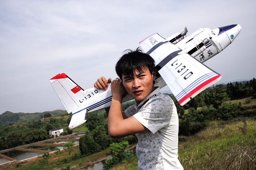
Hu Bo carries his model Y-12 aircraft after taking it out for a flight in Dazu County, Chongqing, May 16, 2017. Wu Yue/Sixth Tone

Hu Bo carries his model Y-12 aircraft after taking it out for a flight in Dazu County, Chongqing, May 16, 2017. Wu Yue/Sixth Tone

Regulations aside, there are other matters that stand in the way of Hu’s passion. His parents recently moved from Guangdong to Chengdu in Chongqing’s neighboring Sichuan province to join a relative’s wholesale grocery company. Hu has been earmarked as one of the company’s delivery drivers, and so has spent the last few weeks preparing for his driving test.

The day after the maiden flight of Hu’s Y-12, he and Xu made the 230-kilometer bus ride to Chengdu, leaving behind Hu’s grandmother and sister. True to his vow never to leave his son, Hu has taken An An with him; true to his passion, Hu has also taken some basic tools and the plans for a massive, 2.4-meter-wide model of China’s new military transporter, the Y-20, despite the fact that he’ll struggle to find anywhere in the metropolis of Chengdu to fly it.

“If I go a day without making planes, then I feel like a smoking addict who hasn’t had a cigarette,” says Hu. One day, he says, he’ll harness that addiction and open a small workshop with a few employees making several planes a day. “That way, my family can have a better life.”

Read more…

At present, we use the following configuration that suitable to doing outdoor work. We start to sell the whole set now.

Take off:
Catapult: Skywalker

Landing
Parachute:Skywalker

Specification:
ESC:Hobbywing Platinum 80A
Motor:Dualsky 4255KV505
Servo:Hitec 5085MG
Parachute bay: Skywalker
Propeller:Skywalker 14*8

You could see the relative components in detail under below.
Catapult:Skywalker

3689716307?profile=original

3689716271?profile=original

3689716288?profile=original

3689716331?profile=original

Parachute:Skywalker

3689716350?profile=original

3689716098?profile=original

3689716356?profile=original

Parachute bay: Skywalker

3689716377?profile=original

3689716474?profile=original

3689716419?profile=original

3689716506?profile=original

3689716553?profile=original

Propeller:Skywalker 14*8

3689716440?profile=original

3689716564?profile=original

If you have any question, you could contact with me at Sales@skywalkermodel.com or skywalker-rc@hotmail.com.

You could see the video, that you will find my Youtube account. You could see some video of Skywalker new information by subcribing it. You could review and give some suggestion to me. Thank you for your visit!

Read more…

Police Drone Camera Zoom Lens 18X 4K

Improving upon the series of drone camera zoom lenses by Walkera for Police use, the all-new 18X 4K increases the speed, performance and optical quality while maintaining all of the functionality made for the integrated 3-axis gimbal.  We took the Voyager 4 with the new lens for a test to share some of the first few takes.

  • Brand: Walkera
  • Camera: 18x Optical Zoom 4K 30FPS
  • Sensor: 1/2.8 SONY IMX222 CMOS sensor
  • Video Resolution: 4096 x 2160
  • Compress Standard:  H.264 / H.265 
  • Files Format:  MP4/JPG
  • Gimbal: Pitch rotation -90°~ +45°; +- 150 degrees rotation

Source at http://youtube.com/dronemission


3689716147?profile=original

Read more…
Moderator

3689716227?profile=original

Not satisfied with the specs of off-the-shelf brushless DC motors? Looking to up the difficulty level on your next quadcopter build? Or perhaps you just define “DIY” as rigorously as possible? If any of those are true, you might want to check out this hand-wound, 3D-printed brushless DC motor.

There might be another reason behind [Christoph Laimer]’s build — moar power! The BLDC he created looks more like a ceiling fan motor than something you’d see on a quad, and clocks in at a respectable 600 watts and 80% efficiency. The motor uses 3D-printed parts for the rotor, stator, and stator mount. The rotor is printed from PETG, while the stator uses magnetic PLA to increase the flux and handle the heat better. Neodymium magnets are slipped into slots in the rotor in a Halbach arrangement to increase the magnetic field inside the rotor. Balancing the weights and strengths of the magnets and winding the stator seem like tedious jobs, but [Cristoph] provides detailed instructions that should see you through these processes. The videos below shows an impressive test of the motor. Even limited to 8,000 rpm from its theoretical 15k max, it’s a bit scary.

(Dan Maloney - HackaDay.com)


fxDH1tl.png?width=600

But, How it works? 


This is the Halbach array setup. Every 5 magnets the pattern repeats. https://en.wikipedia.org/wiki/Halbach_array for more information.

Here is the explanation / assembly video

Alexandre Mainardi

Read more…

3689716205?profile=original

The Groundhog is being developed to line-follow at low altitude and higher speeds.  This video is of the field testing taking the speed up to 1.75 m/s.  It also explains why the Groundhog now sports sunglasses.

The Track

An oval of 50mm red webbing, bends of radius approx 3m and straights of approx 15m. Testing took place in early morning with glancing sunlight on dew-soaked webbing - great for walking the dog but not so good for computer-vision.

https://youtu.be/T3pq6Uqg9Ko

On-board at 1.75 m/s

https://youtu.be/SLBZ4z9_k1M

Image recognition is by OpenCV on a Raspberry Pi 3 as explained in previous blogs.

Image Processing


Frame rates of over 40 fps are achieved by:

  1. Capturing and processing images in a separate thread;
  2. Processing only two roaming regions of interest as shown by the blue bands above;
  3. Using trigonometry to calculate bearings instead of image transformations.


The reality is that the PiCam is only delivering 30fps, so many frames get processed twice.

Flight Control


The position and bearing of the line is calculated in NED space from the orientation of the UAV and pitch of the camera.  A velocity vector is calculated to partly follow the line and also to 'crab' over it.  The velocity vector is sent to the Pixhawk via Dronekit, set to a fixed magnitude.  The Pixhawk is running Arducopter in Guided flight mode.  In these videos, the velocity is set at 1 m/s,  1.2 m/s, 1.4 ms and finally 1.75 m/s.

Performance

  1. Line following was reliable at all velocities up to 1.4 m/s at an altitude of 2m.
  2. The polaroid filter was effective at cutting out much surface reflection, permitting better performance when flying into the sun.
  3. At 1.75 m/s and 2m altitude, lock was lost occasionally when turning into the sun. This was due to more of the line passing out of the field of view and the challenging conditions due to surface reflection.  This is clearly seen from the on-board video above.
  4. Raising the altitude to 3m increased the field of view and allowed for reliable lapping of the track, even at 1.75 m/s.  However, the intention is to fly lower, not higher!
  5. A separate yaw test (full lock in loiter) indicated that despite being 3Kg, the maximum rate of rotation was not a limiting factor to following the track at higher speeds.

What Next?


To get lower and faster, we need to find a way to keep the track in the field of view. Some possibilities are:

  1. Use yaw more aggressively;
  2. Use a wide angle lens.


So back to the drawing board, but in the next field test maybe we'll target velocity of 2m/s at 1.5m altitude - so faster and lower.

More information on the Groundhog at www.mikeisted.com

Read more…

3689716184?profile=original

Hovering Navio2-powered hexa to keep you reading

We’ve recently released a new version of Emlid Raspbian for Raspberry Pi and Navio. It got a modernized interface making the way you interact with Navio even easier.

This update also adds notable features simplifying software development and hardware integration. All this expands the scope of applications within all the same and only RasPi and Navio on board of your drone!


Updates:


ArduPilot:

  • ArduCopter 3.4.6, ArduPlane 3.7.1, ArduRover 3.1.2 are preinstalled by default

  • a bunch of systemd scripts to get you in the air as easy as it can be and also minimizing risks of misconfiguration

  • easy frame selection

ROS (Indigo):

  • For those looking to expand Navio capabilities beyond what ArduPilot offers, Robotics Operating System now comes preinstalled. It is a robust and accessible framework to build complicated robots.

  • Indigo release

  • mavros

  • Mavproxy

  • Extensive documentation


Do you remember Robotic Mower with the Navio2, it’s running ROS:


emlidtool:

  • This is a new tool to make it easier for you to get information about your board, OS, kernel and etc. It will be used for other awesome features in the future. Just type emlidtool to get a hang of it!


Experimental Wi-Fi broadcast:

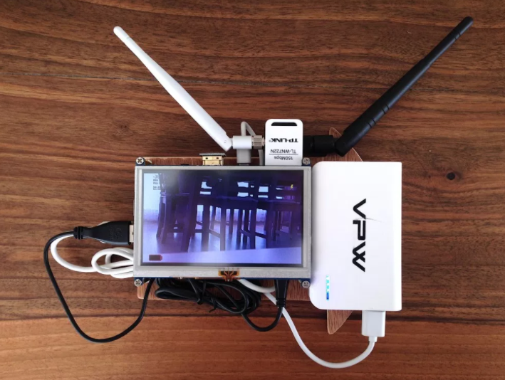
  • Lets you broadcast video stream over Wi-Fi without introducing handshake delays giving you a feel of analogous video stream. It supports two chipsets at the moment (Ralink RT5572 and Atheros AR9172).


Check out Wi-fi broadcast projects by our community member Yannis in his blog.

pvxtkgSiosJn1ZBukjoLa1n3MCC9YhTktfDBB6IQ9Ub8G9rf58GL4PYO65CY_r5FTBgqFxQd9dXxPoPein5nqmr2jzAWIBoZYwn3K9iIWhFImpn2D18k_ruz2w_pntb_q2lXqC0Y

With the latest firmware update we've updated the developer section in our docs. It's easy to start programming RasPi+Navio with many examples available in Python and C++:

  • Barometer
  • ADC
  • PWM output
  • RC input
  • RCIO
  • 9DOF IMU
  • AHRS

  • GPS
  • RGB LED

In the end, here is a cool autonomous RC car with Navio2 running modified Donkey (the tutorial):


Subscribe to our Newsletter and join Emlid Community! 

You can order Navio2 in our store.

Read more…
Moderator

john-a-taylor.jpg?width=300

Should you be in America and come across this man you should probably buy him a beer. He fought the FAA and won. Their mucking about with 336 was not viewed well by the courts,

https://www.suasnews.com/2017/05/john-taylor-defeats-faa-registration-rule-model-aircraft/

We discussed the Taylor case and other advocacy subjects in our weekly hangout a couple of weeks ago,

Read more…

3689716050?profile=original

Hi,

This is the eighth part of our autopilot precision series in which we test the different drones and autopilots by flying them on a simple photogrammetry route created in UgCS mission planning software.

This week it’s finally time to put the Lockheed Martin Indago professional drone to the test. See the video below for flight results:


Download the KML files and take a look at them yourself in Google Earth:
https://www.ugcs.com/en/page/comparing-precision-of-autopilots-for-survey-missions

Get the newest version of UgCS here:
https://www.ugcs.com/en/page/download

Safe flights,
UgCS Team

Read more…
3D Robotics

From New Atlas, a writeup on new research from ETH and MIT:

Thanks to new research from MIT and ETH Zurich, however, it may soon be possible for drones to autonomously follow along with an actor, keeping their face framed "just right" the whole time – while also avoiding hitting any obstacles.

To utilize the experimental new system, operators start by using a computer interface to indicate who the drone should be tracking, how much of the screen their face or body should occupy, where in the screen they should be, and how they should be oriented toward the camera (choices include straight on, profile, three-quarter view from either side, or over the shoulder).

Once the drone is set in action, the computer wirelessly sends it control signals that allow it to fly along with the actor as they walk, adjusting its flight in order to maintain the shot parameters. This means that if the actor were to start turning their back on the drone, for instance, it would automatically fly around in front of them, to keep their face in the shot. Likewise, if they started walking faster, the drone would also speed up in order to keep them the same distance from the camera.

It's additionally possible for the aircraft to follow small groups of actors, working to keep that group framed a certain way within the shot. The user can stipulate one of those actors as the main subject, ensuring that the drone moves in order to keep other actors from blocking the camera's view of them.

The system utilizes algorithms that predict the actor's trajectory about 50 times a second, allowing the aircraft to effectively stay one step ahead of the action. This also allows it to correct its own flight path if its onboard sensors detect that it's heading toward a stationary obstacle, or if a moving obstacle (such as an actor) is on a collision course with it.

A team led by MIT's Prof. Daniela Rus will be presenting a paper on the research later this month at the International Conference on Robotics and Automation. The system is demonstrated in the video below.

Source: MIT

Read more…

3689716068?profile=original

There is no question that we are living in the midst of a drone revolution. Consumers around the world are being captivated by the prospect of controlling these high-tech flying machines, and questions about their safety are beginning to emerge. An early 2017 report published by The New York Times indicates that drones are literally flying off store shelves: 1.2 million were sold as holiday gifts for a grand total of 2.8 million drone purchases in 2016.

It can be safely said that drones can only be as safe as the people who interact with them, but here are five things to keep in mind in this regard:

Sharp Blades

In 2015, pop singer and heartthrob Enrique Iglesias suffered a gruesome injury during a live performance in Mexico as he reached out to touch a drone that had been filming him onstage. His fingers were deeply cut and lacerated by the rapidly spinning blades of the drone; although Iglesias finished the concert for the benefit of his fans, he suffered permanent nerve damage.

Aircraft Interference

3689716119?profile=original


One of the scariest incidents involving a drone and a passenger airplane occurred at London's Heathrow Airport in April 2016. A drone collided against a British Airways flight on its final approach; thankfully, this incident unfolded without injury, but it calls into question the safe operation of these devices.

Falling Objects

Ed Leon Klinger, a risk analyst whose work in the unmanned aerial vehicle industry is widely respected, has stated that one of the major concerns involving drones is their potential for becoming falling objects in congested urban environments such as busy downtown districts. This concern comes about at a time when online retail giant Amazon is planning on using drones to deliver products. 

Security Incidents

In January 2015, a government worker operating a drone in the District of Columbia lost control of the device, which crashed onto the White House lawn and sent Secret Service scrambling to protect former President Barack Obama because they believed it was an attack. A few months later, French security analysts released a report on the numerous drone sightings near nuclear reactors and weapons stations. 

Privacy Concerns

3689716026?profile=original


A few years ago, officers from the London Metropolitan Police Service arrested a drone pilot who was used to taking aerial shots of the city's landmarks. Although the pilot was eventually released without prosecution, lawmakers in England have been working on new measures to regulate drones so that they do not infringe upon privacy.


In the end, drones may only appear to be dangerous at this time because they are relatively new consumer items that awaiting regulation and familiarization by society as a whole.


References:

https://www.nytimes.com/2017/01/08/business/drone-safety-risk-popular.html

https://www.theguardian.com/music/2015/jun/03/drone-injury-grounds-enrique-iglesias-for-longer-than-expected

https://www.dolmanlaw.com/legal-services/personal-injury-attorneys/pip/

http://www.bbc.com/news/uk-36067591

http://www.standard.co.uk/news/london/drone-flying-london-police-alert-landmarks-illegal-london-eye-tower-bridge-9959511.html

Read more…

Takeoff from a nearby island, survey another one, then come back and land autonomously... No problem!

 3689715969?profile=original

On December of 2016 Aeromao Inc. in collaboration with Foresight Surveyors completed a full photogrammetric survey mission with an Aeromapper Talon over one of the most unique and exotic islands in the Maldives, surveying a total area of approximately 251 acres or 1 Sq. Km. at a GSD of 2cm/pixel. The UAV flew at a cruise altitude of 100 m AGL and collected 1422 photos with an amazing level of detail. A DSM, orthophoto and point cloud were generated using Pix4DMapper. Despite the 2 hour flight endurance capability of the Aeromapper Talon, the mission was successfully completed in only 45 minutes. The UAV flew at a maximum distance from the ground control of 2km.

The UAV flew flawlessly and was launched and recovered via parachute from a nearby island approximately 1 km away, due to the limited space available for takeoff and landing on the target island.

The Aeromapper Talon was not equipped with PPK GNSS system, so 5 GCS points were taken on the island which resulted in a horizontal accuracy of 4.8cm

The mission resulted so successful that the crew had plenty of time to go snorqueling around the island while the computers processed all the data.

The Aeromapper Talon utilized is owned by Foresight Surveyors purchased by the year 2014. An upgrade and service was performed to get the UAV up to date prior to the flights over the island.


Centimeter level accuracy required...  Bring it on!


The purpose of the survey was to generate an orthophoto to trace the As-built for future developments taking place in the island. Thanks for the data acquired, the client received an up-to-date high resolution property map which was easier to be used by the project department and decision makers. As well the othophoto was useful for their environmental monitoring purposes and biodiversity mapping.


Project

Sonevafushi Topographic/ As-Built Survey

Average Ground Sampling Distance (GSD)

2.04 cm / 0.8 in

Area Covered

1.0166 km2 / 101.665 ha / 0.3927 sq. mi. / 251.349 acres

Geo-referencing

5 GCPs (5 3D), mean RMS error = 0 m

Dataset

1422 images


About Foresight Surveyors: pioneers in UAV service in the Maldives region


Foresight surveyor is the first company to introduce unmanned aerial vehicle mapping to the Maldives. Foresight Surveyors decided on the Aeromapper Talon because of its ease use, dependability and affordability.

Equipped with the best technology, Foresight Surveyors provide comprehensive range of surveying and survey related consultancy, which includes topographical survey, bathymetry survey and engineering survey services, using traditional Techniques and modern technologies to produce well presented and accurate data.

For more information about Foresight Surveyors please visit http://www.foresightsurveyors.com/?v=77d96fc8e5c0


Snorqueling in the Maldives upon UAV landing


The Maldives consists of 1,192 coral islands grouped in a double chain of 26 atolls, along the north-south direction, spread over roughly 90,000 square kilometers (35,000 sq mi), making this one of the world's most dispersed countries. It lies between latitudes 1°S and 8°N, and longitudes 72° and 74°E. The atolls are composed of live coral reefs and sand bars, situated atop a submarine ridge 960 kilometers (600 mi) long that rises abruptly from the depths of the Indian Ocean and runs north to south.

Maldives is the lowest country in the world, with maximum and average natural ground levels of only 2.4 meters (7 ft 10 in) and 1.5 meters (4 ft 11 in) above sea level, respectively. In areas where construction exists, however, this has been increased to several meters.


Aeromappers: affordable professional mapping solutions


Aeromao Inc. is a Canadian leading UAV manufacturer since 2011, developer of the Aeromapper series of turnkey unmanned aerial vehicles for mapping, surveying, precision agriculture and remote sensing.

With exports to more than 45 countries in less than 4 years after founding, Aeromao Inc. offers a line of products that adapt very quickly to market demands and to unique client’s applications, where no other UAV manufacturer goes. From wildlife monitoring in the Artic to water quality monitoring in Saskatchewan, to urban mapping in Thailand, the Aeromappers are currently being used by private companies, research organizations, universities and government agencies all over the globe for a wide variety of applications.

For more information please visit:   http://aeromao.com/


For the full article and sample imagery please go to: http://www.aeromao.com/maldives/

3689715924?profile=original 

3689715969?profile=original

3689716002?profile=original

3689715945?profile=original

3689715849?profile=original

Read more…

3689715823?profile=original
Robots that Learn

We’ve created a robotics system, trained entirely in simulation and deployed on a physical robot, which can learn a new task after seeing it done once.

Check out the video!

Algorithms

Last month, we showed an earlier version of this robot where we’d trained its vision system using domain randomization, that is, by showing it simulated objects with a variety of color, backgrounds, and textures, without the use of any real images.

Now, we’ve developed and deployed a new algorithm, one-shot imitation learning, allowing a human to communicate how to do a new task by performing it in VR. Given a single demonstration, the robot is able to solve the same task from an arbitrary starting configuration. 


General procedure

Caption: Our system can learn a behavior from a single demonstration delivered within a simulator, then reproduce that behavior in different setups in reality.

The system is powered by two neural networks: a vision network and an imitation network.

The vision network ingests an image from the robot’s camera and outputs state representing the positions of the objects. As before, the vision network is trained with hundreds of thousands of simulated images with different perturbations of lighting, textures, and objects. (The vision system is never trained on a real image.)

The imitation network observes a demonstration, processes it to infer the intent of the task, and then accomplishes the intent starting from another starting configuration. Thus, the imitation network must generalize the demonstration to a new setting. But how does the imitation network know how to generalize?

The network learns this from the distribution of training examples. It is trained on dozens of different tasks with thousands of demonstrations for each task. Each training example is a pair of demonstrations that perform the same task. The network is given the entirety of the first demonstration and a single observation from the second demonstration. We then use supervised learning to predict what action the demonstrator took at that observation. In order to predict the action effectively, the robot must learn how to infer the relevant portion of the task from the first demonstration.

Applied to block stacking, the training data consists of pairs of trajectories that stack blocks into a matching set of towers in the same order, but start from different start states. In this way, the imitation network learns to match the demonstrator’s ordering of blocks and size of towers without worrying about the relative location of the towers.


Block stacking

The task of creating color-coded stacks of blocks is simple enough that we were able to solve it with a scripted policy in simulation. We used the scripted policy to generate the training data for the imitation network. At test time, the imitation network was able to parse demonstrations produced by a human, even though it had never seen messy human data before.

The imitation network uses soft attention over the demonstration trajectory and the state vector which represents the locations of the blocks, allowing the system to work with demonstrations of variable length. It also performs attention over the locations of the different blocks, allowing it to imitate longer trajectories than it’s ever seen, and stack blocks into a configuration that has more blocks than any demonstration in its training data.

For the imitation network to learn a robust policy, we had to inject a modest amount of noise into the outputs of the scripted policy. This forced the scripted policy to demonstrate how to recover when things go wrong, which taught the imitation network to deal with the disturbances from an imperfect policy. Without injecting the noise, the policy learned by the imitation network would usually fail to complete the stacking task.

source: https://blog.openai.com/robots-that-learn/

Read more…

Links:

Description: 

The OpenGrab EPM v3 is an electropermanent magnet, combining the advantages of electro and permanent magnets. The device creates a very strong magnetic contact with a ferrous target. It supports UAVCAN, RC PWM and push button operation. OpenGrab EPM v3 has been developed by NicaDrone in cooperation with Zubax Robotics.

Read more…

Precis-BX306 is a GNSS RTK board (GPS L1L2/GLONASS G1G2/BDS B1B2) for accurate position. This board offers real-time & cm-level positioning capability and uses standard serial port module for communication. A special connector makes it easy to integrate to its host devices or autopilots.

Take a look at its performance on the city streets with tree cover & tall buildings. 

Read more…

3689715858?profile=original

What is the difference between a low cost, hobby grade LiDAR and a much more expensive survey grade LiDAR? The short answer is that there are lots of differences. So the challenge becomes figuring out how to use the latest technology to achieve survey grade performance in a small, low cost package.

Ideally, a LiDAR should have perfect performance so that exact distances and angles can be measured instantaneously. This would result in precise 3D point clouds that can be used in conjunction with photogrammetry or directly for inspection and mapping. In reality, there are limitations to the performance of any product and in the case of LiDAR these limitations include:

  • The size of the laser footprint on the ground
  • The maximum measuring range achievable
  • The absolute distance measurement accuracy
  • The update rate of new measurements
  • The precision of the aiming direction
  • Knowledge of the position of the LiDAR itself

Each of these performance parameters can be very difficult to improve on and this is one of the reasons why high performance LiDARs cost several orders of magnitude more than those that might appear to do the same job.

Up to now, we (LightWare dev team) have been concentrating our LiDAR development program on making high quality, low cost LiDAR systems that are lightweight enough to use on small drones. Our emphasis has been on measuring the height above ground and locating obstacles in front of the drone since these applications have more relaxed specifications when compared to precision mapping. However, we have a longer term program to produce very precise mapping LiDAR at low cost and I would like to share with you our first steps in this direction.

The LW21 prototype pictured above is a variant of the ultra-small LW20 LiDAR that was released earlier this year. The LW20 configuration was developed with high performance applications in mind which is why it includes professional grade features such as an IP67 rated housing made from aluminum, first and last signal detection, long range and so on. In the LW21 we have added new optics and modified the laser beam in order to reduce the size of the ground footprint.

A small ground footprint is critical to obtaining precise measurements. You can think of this as the "pixel" size of the LiDAR and making the pixels smaller means that you know with greater certainty which point on the target surface is providing the return signals. This improves to the angular precision of the measurements.

The difficulties in making a small footprint relate to the beam divergence of the laser. The pulsed lasers used in time-of-flight LiDAR have a large chip size resulting in a much bigger emitting area than you would find in a regular, visible laser pointer. This larger chip makes it difficult to design a simple and small system of lenses that produce good collimation (a parallel beam). Instead, light from the edges of the laser chip travel in a slightly different direction from light at the center, making the edges of the laser beam diverge.

Replacing the laser with a smaller chip means that the transmission power will be reduced and therefore the signal strength and measuring range decrease. However, in the LW21 we have managed to introduce a smaller laser chip but still maintain the range. This has reduced the area of the ground footprint by a factor of 4.

The next limitation relates to the small physical size of the lenses. Small diameter lenses with short focal lengths have  poorer optical characteristics than larger lenses, introducing distortions and a wide field of view. They also have a smaller collecting area so that return signals appear to be weaker. So this is why survey instruments that use lasers are quite large.

There was no way to economically overcome these fundamental, optical limits so we increased the focal length of the lenses thereby reducing spherical aberration and reducing the beam divergence by another factor of two on each optical axis.

The net result of these modifications is that the LW21 prototype gives a beam divergence of around 1.7mRad producing a spot size just 12cm across at a range of 50m. By comparison, the Velodyne Puck has a beam divergence of 3.0mRad producing a spot with almost four times the area of the LW21.

So what's next? We are currently working on a high precision aiming mechanism that will provide very accurate information about the direction that the LW21 is aiming. I'll keep you posted ;).

Read more…
MR60

This is a quick and short review, setup and tutorial of the RTK XL GPS from uBlox/Drotek.

Test & Setup is done on Ardupilot + Pixhawk, using mission planner as the ground control station.

Note that this product was not provided for review by Drotek and the review is unbiased.

The RTK XL product can be found here:
https://drotek.com/shop/en/home/792-x...

U-Center software from uBlox can be downloaded here:
https://www.u-blox.com/en/product/u-c...

Drotek's product documentation can be found here:
https://drotek.com/en/lessons/comment...

Read more…

The Groundhog UAV - Curved line following

3689715794?profile=original

It's been a few week since tests were conducted of The Groundhog line-following a straight red line.  The Groundhog was an entry in the MAAXX Europe 2017 competition and although it didn't win, the lessons learned are being implemented so that it can be more competitive next year.

Time and weather have eventually converged to permit testing for the oval track - in this case a 50m oval comprising 50mm wide red webbing.

The test turned out to be quite successful, with following speeds of 1.5m/s achieved under autonomous control provided by an on-board Raspberry Pi 3.  This is significantly faster than the winning UAV in MAAXX Europe this year, which is quite pleasing!

The YouTube video shows both on-board and off-board camera footage, the former demonstrating the roaming regions of interest used by OpenCV to maintain a lock under varying lighting conditions.

https://youtu.be/UGCw27Atork

The next steps are to increase the speed still further and control the altitude more precisely.

More information on the Groundhog can be found at www.mikeisted.com.

Read more…