All Posts (11086)

Sort by

Recently I've stumbled upon a very nice master's project on vice.com:

It looks cooler than Google’s self-driving panda car, even if it’s only miniature. This model bike is a step toward fully autonomous motorcycles and overcomes a main challenge with two-wheeled vehicles: not falling over.

Eric Unnervik, a master’s student at the École Polytechnique Fédérale de Lausanne (EPFL) in Switzerland, developed the mini bike to demonstrate some of the technology that could lead to full-on autonomous motorbikes. At the moment, the bike needs a human controller to tell it where to go via a remote control as it has no GPS, but it can ride there by itself—crucially, without flopping on its side.

In a video, Unnervik explains (in French) that his grown-up Hot Wheels toy contains a Raspberry Pi computer with NAVIO2 autopilot and sensors that measure the bike’s angle and speed. A servomotor adjusts the steering angle as needed so the bike won’t fall as it travels up to 60 km/h.

He says he’d ultimately like to race a 100 percent autonomous bike against one with a rider.

Cars have so far stolen the autonomous road vehicle limelight, though Yamaha unveiled a motorbike-riding robot at CES this year, and Google has lobbied to keep regulations open to testing autonomous motorcycles.

The question remains as to quite why anyone would want a motorbike that drives itself—to get that wind-in-your-hair feeling without the hard work, perhaps?

Photo from the Recantha:

The Mini Bike

© 2016 EPFL / Alain Herzog

Original source with action video

Read more…

UAVCAN status update

Greetings, my fellow humans.3689700315?profile=original

In this update I will briefly review the current state and the near future of UAVCAN. For those unfamiliar, UAVCAN is a lightweight CAN bus protocol designed for reliable communication in aerospace and robotic applications. It aims to provide standardized and unified communications at the application level by means of defining a fixed set of messages and RPC services, at the same time maintaining flexibility by virtue of vendor-specific (custom) message and service definitions. I will not focus on the technical details here - those interested can learn more directly from the specification at uavcan.org.

The first release-candidate version of the protocol was announced almost a year ago; since then, no significant changes were introduced, and therefore the specification can be considered almost mature enough for the first release. There certainly will not be any significant breaking changes. The current pre-release version is implemented in the following three official implementations:

3689700281?profile=original

  • Libuavcan - this is the reference implementation in C++, mostly targeted at embedded systems and Linux. Being the reference implementation, Libuavcan is the most feature complete library and it sports the best documentation with elaborate tutorials.
  • Pyuavcan - a Python 2.7/3.x package, primarily targeted for testing, scripting, development of GUI tools, etc. This package is compatible with Linux, Windows, and OSX. The UAVCAN GUI Tool (more on it later) is based on Pyuavcan.
  • Libcanard - an alternative for Libuavcan for extremely resource constrained microcontrollers. Libcanard is a minimal implementation in pure C99 with no third party dependencies that works anywhere from low-end 8-bit AVR up to desktop Linux systems. This library is still sort of under development - it is generally feature-complete, but there's no comprehensive documentation published yet. We compensate the lack of documentation by this neat demo.

3689700320?profile=originalAnother interesting thing that we made is the UAVCAN GUI Tool - a neat open source cross-platform application for bus management and diagnostics that runs on Windows, Linux, and (sort of) OSX (the project could use help from an OSX guru to resolve some packaging issues). The screenshots on the right are intended to demonstrate just how neat it is. It supports a bunch of use cases:

  • Bus sniffing with transfer dissection.
  • Plotting values from the bus in real time.
  • Node reconfiguration and firmware upgrade over the bus.
  • Python scripting with interactive IPython console.
  • Support for different CAN hardware backends.

3689699136?profile=originalSpeaking about tools, it is also worth noting Zubax Babel - a Swiss knife of a CAN adapter. Zubax Babel is a USB-CAN and UART-CAN adapter that can also be used as a UAVCAN dev board. The full specs are here, orderable from TitanElite, Inc.

As for other hardware, I put together a brief list of some of the most notable projects and products that leverage UAVCAN:

  • Zubax Robotics - GNSS 2 (advanced GNSS module), Orel (ESC based on the PX4 Sapog firmware), and already mentioned Babel.
  • OpenGrab EPM from NicaDrone (electropermanent magnet). This device is based on an interesting MCU - LPC11C24, a true single-chip CAN solution - a low cost MCU with embedded CAN controller and a CAN transceiverin the same package. This MCU is supported by Libuavcan (and soon will be supported by Libcanard too).
  • Projects from Thiemar. Sadly, the hardware doesn't seem to be available at the moment.
  • MAPIR Kernel camera for aerial imagery.
  • The Paparazzi project appears to be in the process of integration with UAVCAN (by means of Libcanard). There's a video showing some kind of PoC.
  • Obviously, PX4 and APM, including the official and derivative hardware designs.

We believe that the new tools and commercially available hardware should further incentivize UAV vendors, integrators and researchers to abandon inherently flawed interfaces (especially I2C and PWM) in favor of UAVCAN. There is a Gitter channel and a mailing list for those who have questions or just want to stay in the loop; furthermore, we at Zubax Robotics can provide assistance for companies and projects that are willing to adopt UAVCAN but lack relevant expertise. Also remember that with UAVCAN, everything is open source and licensed under MIT or in the public domain; as such, all specifications are completely free to use or distribute, and the reference implementations can be used in closed source commercial projects with no strings attached. Go have a look at our GitHub profile to learn more.

Pavel.

Read more…
300km

Anatomy of a 425km Flight

3689700365?profile=original

On the weekend I did a 425km flight with my Vigilant C1.

Setting a new distance record is something I’ve been slowly working towards ever since flying 301km with the Cyclops EPO plane in 2014 

John Smith and Gene Robinson of RP Flight Systems supported me by providing the Vigilant C1 airframe. It has a 3m high aspect wing and loads fuselage space making it ideal for long endurance missions.

In terms of flight testing the biggest performance gain was from tuning the powertrain setup. I tested two options, a 4S battery vs a 6S battery with the stock 300kVa motor. The 6S with stock motor won hands down with a performance difference of around 25%.

I also tested half a dozen different propellers, a couple of APM parameter settings, three different flying patterns and different battery payload capacities.

I tested each parameter by flying repeated circuits of an octagonal test lap and analysing the telemetry log files to work out the power consumption. I could calculate the watts used and the distance covered to work out the best settings. I could extrapolate those figures to see how far I could fly if I used the full battery load.

One dilemma I faced was concerning the flaps. With such an efficient airframe heavily loaded I wanted flaps to control the airspeed and glideslope for landing. But I didn’t want to power the flap servos and carry the weight for the whole flight when I only needed them for 30 seconds at the very start and end of the flight. In testing I gradually reduced the flaps each landing and was relieved that I could land easily with a long low approach. I did however have trouble taking off. I used a bungee that dragged the plane along the ground. Even though I achieve plenty of speed, the fact it was on the ground meant I couldn’t rotate to pitch up. With flaps I had enough lift to take off every time but without them I couldn’t.  It took three attempts without flaps the first time to get airborne and even then it only happened because I hit a bump that bounced me up off the ground. I decided to remove the flap servos and glued the flaps in place and I made a ramp out of some plywood sheets and used that for the first time for the record attempt. 

With the 6S setup I used a HobbyKing power module and the figures it gave in testing seemed too good to be true. I calibrated it against the amount of energy the charger put back in and that showed the power module had been underreporting the current used by about 25%.

I watched the weather and picked the best day I could have hoped for. It was very calm for the first half of the flight with only a light wind later in the day. I flew a large loiter circle (guided mode) with a 600m radius giving almost 2km per lap.

I tracked distance covered vs battery voltage and vs battery percentage remaining and found gave very consistent results that sat just above the 400km projection line all day.

3689700080?profile=original

I trusted the voltage reading more than the battery percentage remaining. I knew the Li Ion batteries would be 95% depleted when they reached 3V per cell so I planned to terminate the flight at that point.

All in all it was a big day, 425km of flying taking 7 hours, 48 minutes.

What I’m most excited about is the possibilities this milestone opens up. With an airframe like this the range limitations for tasks such as pipeline monitoring, mapping and search and rescue have just been moved to another dimension altogether.

Setup Details:

  • Plane Vigilant C1 V tail – fibreglass and carbon fibre construction with 3m wingspan.
  • Stock Vigilant C1 motor – 300kVa
  • Pixhawk autopilot
  • Panasonic 18650B Li Ion batteries. 6S 9P = 30600mAh.
  • Aeronaut CAM Power Prop 13x12
  • HobbyKing telemetry module
  • HobbyKing power module
  • Distance covered: 425km (264miles)
  • Flight duration: 7hr 48 min.
  • Average groundspeed 15.3m/s (55km/hr)
  • AUW = 5.7kg (12.5lbs)
  • Goteck DA2311T Servo
  • ZTW 65A Gecko ESC


Read more…


Ultra precise positioning at low cost and reduced form factor.

We just release TINY RTK, the world smallest RTK GPS based on u-blox NEO-M8P.

Size: 23.5 x 24.5 mm

3689699935?profile=original

Key features

  • Centimeter‑level GNSS positioning for mass market, based on U-Blox M8P
  • Integrated Real Time Kinematics (RTK) for fast time‑to‑market
  • Smallest, lightest, and best energy‑efficient RTK module
  • Receiver type: 72-channel GPS L1 , GLONASS L1, BeiDou B1, GALILEO E1
  • Nav. update rate: up to 8 Hz
  • Position accuracy: 2.5 cm
  • Connectors: SMA, USB, JST-GH
  • Data link: whatever can be connected to a UART : Bluetooth, 433-868-915 MHz radio link, XBee, WiFi...

We've decided to launch an INDIEGOGO campaign to lower chip prices by ordering mass. 

If you're interested by precision GNSS and want a Plug&Play solution at an incredible price ... TINY RTK is designed for you ! 

Go To TINY RTK campaign

3689700123?profile=original

We'll post regular informations about TINY RTK during the campaign. We're also available for answering your questions, do not hesitate.


Read more…

3689700152?profile=original

Our group of UAV professional and enthusiasts kickstarted the first attempt for a high-altitude UAV flight in Indonesia. The program which was initiated by AeroTerrascan, an Indonesian UAV designer and manufacturing company, has since grown into a very resourceful collective of Indonesian aeronautic devotees. The formerly named AeroTerrascan Menembus Langit has dropped the company’s branding and now simply known as Menembus Langit. Literally means ‘pierce the sky’.

3689700149?profile=originalMenembus Langit was officially started by the trial flight held at LAPAN’s (Indonesian Institute of Aeronautics and Space) launch facility on 27 August 2016. The privately funded non-profit program successfully lifted a 2.9kg aircraft (600gr worth of payload) with a high altitude balloon up to altitude of 12.7km (41,600 ft) before separated and let it managed to achieve stable flight within seconds. It took more than 40 minutes for the aircraft to glide down in a loiter mode before taken over by the pilot and landed manually. 

While it is (may or) may not exactly a ground breaking achievement in the international UAV world, we certainly hope it will become the start of a big things for the generally-unheard Indonesian UAV industry and community. Especially with the current state of regulations and the fact that we are trying to use off-the-shelf equipments as much as possible and will openly publish our research and findings at the end of the project.

From our mission objectives:
- 
To set a milestone in national aeronautic achievement
- To provide a method for reusable stratospheric research platform
- To pave the road towards HALE platform
- To inspire people, communities and institutions

For the coming month we will keep raising the altitude to reach our target of 30km (100,000 ft) and achieve stable flight at 28km (90,000 ft). We certainly hope our attempt will be able to trigger the rise of Indonesian UAV community as well as South East Asia region. Big thanks to Ardupilot community who has provided us with a system that made it happen.

3689700171?profile=original

3689700221?profile=original

*

Read more…

100km+ in the X-UAV Mini Talon

PerthUAV, like our friends over at WestCoast UAV, have been steadily gearing up for the upcoming 2016 Medical Express challenge. The competition is just two weeks away(!) though already it has been quite a journey... Along the way, we have hit a few milestones (and had our share of failures) many of which, we have been documenting on our facebook page. Over the weekend we cracked the big 100km so I thought I'd share it with everyone here too.

Flight details:

  • Flight time: 2 hrs 17 mins
  • Total flying distance: 115 km
  • Link to flight summary: https://www.exmaps.com/653155
  • Link to flight log: GoogleDrive (boring and very large [~200MB] due to us logging most variables)

3689700249?profile=original

In the end, despite having capacity left in our batteries, we had to land due to diminishing light. Conditions were not perfect; we had an average wind of 8m/s (15 knots), we were not flying with the ideal propeller (see below) and we had to navigate a tighter mission than desired for the majority of the flight to maintain separation to other people using the field.

  • Airframe: Mini Talon
  • Motor: SunnySky X2216 2216 1250KV
  • Prop: Aeronaut folding propeller 10x6" (10x8" is better) 
  • ESC:Turnigy dlux 40A (2~6S)
  • Batteries: 4S 6600mAh Multistar (X2), BATT_CAPACITY set to 10000(mAh)
  • FC: Pixhawk (APM:Plane 3.7)
  • Target airspeed : 17 m/s

On board the aircraft, we had a companion computer (Pi Zero) that provided a C2 link over 3G and was taking pictures when triggered but I will save this (and our SiK radio relay setup) f3689700058?profile=original3689700189?profile=originalor another comms specific post!

Finally, we'd just to take this opportunity to say a big thank you to all those who have contributed to the ArduPilot project, from developers to documenters and donors. None of what we have been able achieve would be possible without Ardupilot.

Read more…

Aerial thermography - high voltage inspection

Nowadays, we cannot imagine life without electricity. Although we take it for granted as a part of our lives we do not always realize how demanding it is to be produced and supplied by power plants directly to our homes. The transmission and distribution network is a highly complex system of lines of interconnecting electric energy sources, transformer stations and consumers. Unfortunately, failures can occur within electricity networks that can lead to electricity breakdowns as well as destructive fires. A UAV (drone) with a thermal imaging system installed can be a very useful tool to prevent such problems.

Aviation inspection using the Workswell WIRIS system

The question is how to check equipment located at great heights, is under high voltage and is located in areas with complicated access. How do you check the network of lines in large transformer stations when the whole system takes up a large area and the inspected elements are difficult to access? The option of aviation inspection is available that has been used in this area for many years.

The thermal imaging system for Workswell WIRIS drones from   Workswell are designed for assembly on the drone (UAV). The set is light, mobile and fully controlled using a standard RC controller. The system combines two camera systems – a camera for visible spectrum (for inspection of visible defects to piping) and a thermal camera (for detection of hidden defects). The servicing software enables remote switching of camera regimes, record radiometric videos and to produce static images in the visible and infra-red spectrum. The operator sees any objects under the drone in real time and can analyse the records in order to identify damaged areas.

Moreover, unlike similar systems, Workswell WIRIS enables the manual setting of set the range of temperatures, e.g. in intervals of 15 °C to 25 °C. Even this range of temperatures can be changed during the flight. Without the need to land, the system can be set for actual situation to easily achieve the required thermal sensitivity setting, which is needed to localize minor moisture defects that may worsen after time and lead to serious problems. Moreover, the system can be equipped with a GPS sensor for storing information on the position of the drone when recording.

Read more…
100KM

100km in the X-UAV Talon

3689699879?profile=original

I have been thinking about sending my X-UAV Talon on a 100km flight and despite pondering it for a long time today I hit the milestone in an unplanned way.

During a checkout flight for our spare support aircraft for West Coast UAV's entry in the 2016 Medical Express challenge I noticed that we had an amazingly efficient combination of airframe/motor/prop and the numbers were looking good for a 100km run.

So up the Talon went carrying 20AH of 3S Multistar batteries driving a NTM1100KV motor and APC 12x10 prop. The average speed was kept low and despite encountering some airspeed measurement issues it crossed the 100km mark at just over 1 hour and 40 minutes airborne.

Logfile Link

The landing was unfortunately a bit hairy and fast as the voltage had dropped fairly low and the airframe copped a few dents but really happy to have knocked over the 100km milestone.

Read more…

Site survey over GSM cellular network

Hi all, 

we have been testing our GSM drone connection module in the field and it performed really well. Here is a short video showing how you can upload a mission and send a drone out completely over cellular network. It's telemetry and path are then available in real-time at our free online platform www.globalarc.us

This opens up the potential for a completely autonomous system (that we are working on as we speak, stay tuned), but also allows centralized command for any commercial application. Our GSM companion that has a 2" touchscreen weighs 1 Oz without the battery and 1.5 Oz with an independent battery. It works with APM and Pixhawk for now and we will announce the availability here very soon. 

Please let us know your thoughts!

Read more…

Drone Formation Flying - 3 Drones

I wanted to try and build on a previous formation flying experiment where 2 drones were used (see more about that HERE) by adding one additional vehicle into the mix, making the formation a bit more complex, and attaching some cool LED orbs to the drones to create a cool effect when flying near twilight.

I thought this turned out pretty well!  Powering all of those USB telemetry antennas out in the field may turn into a challenge since I am running out of USB ports on my laptop!

Similar to my previous 2 drone formation test, all of the position data for each drone is being handled by Systems Tool Kit (STK).  I planned all flight paths in STK and use a Dronekit Python script to constantly ask STK for each drone's position and then instruct the drones in "GUIDED" mode to those positions.

What I find really cool while experimenting with these types of formation tests is the ability to animate the STK plan faster/slower or even play it in reverse and watch it all play out in the sky.  

For some next steps, of course adding more drones is an option, but I would also like to start taking advantage of some of STK's more analytical capabilities to compute separation distances, relative velocities, and angles between vehicles and make decisions based on those calculations in real time, like a simple collision avoidance type of algorithm..... I'd have to really trust my algorithm before risking two of my drones though!!

Read more…
Developer

ArduPilot and DroneCode part ways

3689699968?profile=originalSource: http://discuss.ardupilot.org/t/ardupilot-and-dronecode/11295

For the attention of the users, supporters, fans and corporate users of ArduPilot:

The ArduPilot project is going through a transition. We will no longer be associated with DroneCode and instead will be focused directly on the needs of our users, contributors and partners.

We had high hopes for DroneCode as a collaborative project. DroneCode was born out of the ArduPilot project and we led the technical collaboration since its inception nearly two years ago. As part of that collaboration we welcomed and nurtured close ties with the PX4 project and worked closely with a number of corporate partners.

Unfortunately DroneCode has a built-in flaw. The structure and bylaws of DroneCode are built around exceptional power for the Platinum members, giving them extraordinary control over the future of DroneCode. This is a fundamental flaw in a project meant to promote free and open source software as it means that the business interests of a very small number of members can override the interests of the rest of the members and the community.

Just how great a flaw that is has been shown by the actions of the Platinum members over the last two months. Due to their overwhelming desire to be able to make a proprietary autopilot stack the Platinum members staged what can only be called a coup. They removed all top level open source projects from DroneCode, leaving only their own nominees in the Technical Steering Committee. They passed a resolution requiring that all projects hand over control of all trademarks, accounts and domains to their control.

The PX4 project leadership decided to accept this, and will be handing over control of the PX4 project in order to remain in DroneCode. The ArduPilot project won’t be doing this, as we firmly believe that community directed development is the best way to create a long-term sustainable free software autopilot stack. That means we are not willing to hand control of our domains, trademarks and development accounts to DroneCode, and by extension to the Platinum members. We believe that giving the Platinum members that degree of control over the future of ArduPilot would be irresponsible. ArduPilot is a community project, and its future direction must be set by the community.

We did not want this outcome, and neither did the Silver members (represented by all 3 elected Dronecode board members). We wanted to continue to collaborate, but the actions of the Platinum members and the choice made by the PX4 project means that DroneCode is no longer a place where community directed collaboration is welcome.

There is one aspect of DroneCode which we will miss. It offered a forum where we could work with the many companies that use ArduPilot to help their businesses make the most of ArduPilot.

To allow us to continue to have that relationship and improve upon the flawed DroneCode model we have made the decision to accept partners to the ArduPilot project. These partners will have their logo displayed on our new homepage (unveiled today; visit us at www.ardupilot.org33) and we will work closely with them to build a strong relationship for the benefit of both their businesses and the ArduPilot project.

We will have a monthly meeting between the ArduPilot development team and partners where we will discuss the future direction of ArduPilot and work together on issues that are important to our partners.

More information on becoming an ArduPilot partner is available here:
http://ardupilot.org/partners17

We also welcome individual contributions, with donations welcome from all users. The most important contributions, however, are those made by the hundreds of people in our vibrant community who have contributed code, documentation, code reviews and support for our users.

The ArduPilot development team would like to thank all our users, contributors and partners for their support, and we look forward to continuing the development of the autopilot that this community loves.

The ArduPilot Dev Team
ArduPilot.org

Read more…

NEW ARDUPILOT APM 2.x features: URUS System

3689699836?profile=original

APM:URUS system will be the first autoconfigurable and scalable BRAIN MODULE and a CAPE IO for ROBOTICS and AUTOMATED Systems, thinking on industrial aplications.

We highlighted that an owner with APM 2.x board will can work with lastest Ardupilot releases version.

This system have two parts that their will work together:

  1. URUS system will make APM 2.x boards in a BRAIN MODULE for ROBOTICS and AUTOMATIZATION Systems, maybe industrial (Like a PLC), you will can attach an APM: AUTO_CAPE to enhance the capabilities.

  2. APM:AUTO_CAPE based on URUS system. That make and convert APM 2.x boards as an UNIVERSAL CAPE for ANY platform Boards system and make compatibilty for lastest APM FIRMWARE VEHICLES RELEASES from master branch to work together.

Right now this project are being introduced in Ardupilot by developer Hiroshi Takey.
This development are being voted to be maintained in the Ardupilot master-AVR branch, VOTE FOR THIS if you are interested on the listed links:

http://discuss.ardupilot.org/t/new-ardupilot-apm-2-x-features-urus-system/11297

https://gitter.im/ArduPilot/ardupilot

You will can follow the development at the Ardupilot master-AVR branch at:
https://github.com/ArduPilot/ardupilot/tree/master-AVR


Read more…
Developer

APM:Plane 3.7.0 released

3689651507?profile=originalThe ArduPilot development team is proud to announce the release of version 3.7.0 of APM:Plane. This is a major update so please read the notes carefully.

The biggest changes in this release are:

  • more reliable recovery from inverted flight
  • automatic IC engine support
  • Q_ASSIST_ANGLE for stall recovery on quadplanes
  • Pixhawk2 IMU heater support
  • PH2SLIM support
  • AP_Module support
  • Parrot Disco support
  • major VRBrain support merge
  • much faster boot time on Pixhawk

I'll give a bit of detail on each of these changes before giving the more detailed list of changes.

More reliable recovery from inverted flight

Marc Merlin discovered that on some types of gliders that ArduPilot would not reliably recover from inverted flight. The problem turned out to be the use of the elevator at high bank angles preventing the ailerons from fully recovering attitude. The fix in this release prevent excessive elevator use when the aircraft is beyond LIM_ROLL_CD. This should help a lot for people using ArduPilot as a recovery system for manual FPV flight.

Automatic IC engine support

ArduPilot has supported internal combustion engines for a long time, but until now the pilot has had to control the ignition and starter manually using transmitter pass throughs. A new "ICE" module in ArduPilot now allows for fully automatic internal combustion engine support.

Coupled with an RPM sensor you can setup your aircraft to automatically control the ignition and starter motor, allowing for one touch start of the motor on the ground and automatic restart of the motor in flight if needed.

The IC engine support is also integrated into the quadplane code, allowing for automatic engine start at a specified altitude above the ground. This is useful for tractor engine quadplanes where the propeller could strike the ground on takeoff. The engine can also be automatically stopped in the final stage of a quadplane landing.

Q_ASSIST_ANGLE for stall recovery

Another new quadplane feature is automatic recovery from fixed wing stall. Previously the VTOL motors would only provide assistance in fixed wing modes when the aircraft airspeed dropped below Q_ASSIST_SPEED. Some stalls can occur with higher airspeed however, and this can result in the aircraft losing attitude control without triggering a Q_ASSIST_SPEED recovery. A new parameter Q_ASSIST_ANGLE allows for automatic assistance when attitude control is lost, triggering when the attitude goes outside the defined roll and pitch limits and is more than Q_ASSIST_ANGLE degrees from the desired attitude. Many thanks to Iskess for the suggestion and good discussion around this feature.

Pixhawk2 heated IMU support

This release adds support for the IMU heater in the upcoming Pixhawk2, allowing for more stable IMU temperatures. The Pixhawk2 is automatically detected and the heater enabled at boot, with the target IMU temperature controllable via BRD_IMU_TARGTEMP.

Using an IMU heater should improve IMU stability in environments with significant temperature changes.

PH2SLIM Support

This release adds support for the PH2SLIM variant of the Pixhawk2, which is a Pixhawk2 cube without the isolated sensor top board. This makes for a very compact autopilot for small aircraft. To enable PH2SLIM support set the BRD_TYPE parameter to 6 using a GCS connected on USB.

AP_Module Support

This is the first release of ArduPilot with loadable module support for Linux based boards. The AP_Module system allows for externally compiled modules to access sensor data from ArduPilot controlled sensors. The initial AP_Module support is aimed at vendors integrating high-rate digital image stabilisation using IMU data, but it is expected this will be expanded to other use cases in future releases.

Parrot Disco Support

This release adds support for the Parrot C.H.U.C.K autopilot in the new Disco airframe. The Disco is a very lightweight flying wing with a nicely integrated Linux based autopilot. The Disco flies very nicely with ArduPilot, bringing the full set of mission capabilities of ArduPilot to this airframe.

Major VRBrain Support Update

This release includes a major merge of support for the VRBrain family of autopilots. Many thanks to the great work by Luke Mike in putting together this merge!

Much Faster Boot Time

Boot times on Pixhawk are now much faster due to a restructuring of the driver startup code, with slow starting drivers not started unless they are enabled with the appropriate parameters. The restructuring also allows for support of a wide variety of board types, including the PH2SLIM above.

This release includes many other updates right across the flight stack, including several new features. Some of the changes include:

  • improved quadplane auto-landing
  • limit roll and pitch by Q_ANGLE_MAX in Q modes
  • improved ADSB avoidance and MAVLink streaming
  • smoother throttle control on fixed-wing to VTOL transition
  • removed "demo servos" movement on boot
  • fixed a problem with spurious throttle output during boot (thanks
  • to Marco for finding this)
  • support MAVLink SET_ATTITUDE_TARGET message
  • log all rally points on startup
  • fixed use of stick mixing for rudder with STICK_MIXING=0
  • fixed incorrect tuning warnings when vtol not active
  • support MAVLink based external GPS device
  • support LED_CONTROL MAVLink message
  • prevent baro update while disarmed for large height change
  • support PLAY_TUNE MAVLink message
  • added AP_Button support for remote button input reporting
  • support Ping2020 ADSB transceiver
  • fixed disarm by rudder in quadplanes
  • support 16 channel SERVO_OUTPUT_RAW in MAVLink2
  • added automatic internal combustion engine support
  • support DO_ENGINE_CONTROL MAVLink message
  • added ground throttle suppression for quadplanes
  • added MAVLink reporting of logging subsystem health
  • prevent motor startup on reboot in quadplanes
  • added quadplane support for Advanced Failsafe
  • added support for a 2nd throttle channel
  • fixed bug in crash detection during auto-land flare
  • lowered is_flying groundspeed threshold to 1.5m/s
  • added support for new FrSky telemetry protocol varient
  • added support for fence auto-enable on takeoff in quadplanes
  • added Q_ASSIST_ANGLE for using quadplane to catch stalls in fixed wing flight
  • added BRD_SAFETY_MASK to allow for channel movement for selected channels with safety on
  • numerous improvements to multicopter stability control for quadplanes
  • support X-Plane10 as SITL backend
  • lots of HAL_Linux improvements to bus and thread handling
  • fixed problem with elevator use at high roll angles that could
  • prevent attitude recovery from inverted flight
  • improved yaw handling in EKF2 near ground
  • added IMU heater support on Pixhawk2
  • allow for faster accel bias learning in EKF2
  • fixed in-flight yaw reset bug in EKF2
  • added AP_Module support for loadable modules
  • support Disco airframe from Parrot
  • use full throttle in initial takeoff in TECS
  • added NTF_LED_OVERRIDE support
  • added terrain based simulation in SITL
  • merged support for wide range of VRBrain boards
  • added support for PH2SLIM and PHMINI boards with BRD_TYPE
  • greatly reduced boot time on Pixhawk and similar boards
  • fixed magic check for signing key in MAVLink2
  • fixed averaging of gyros for EKF2 gyro bias estimate

Many thanks to the many people who have contributed to this release, and happy flying!

Read more…

3689699993?profile=original

I've been working with the Swiss Humanitarian Organization FSD on a number of Humanitarian UAV Research Projects since 2015. The results of one of these projects is finally public: The Drones in Humanitarian Actions Survey, funded by EU Humanitarian Aid. The purpose of this survey was to take a closer look at how humanitarian professionals view the use of aerial robotics or Unmanned Aerial Vehicles (UAVs). The survey asked aid workers working in different clusters what they think about the use of UAVs in different situations. Close to 200 disaster responders working across 61 different countries took part in this unique survey.

The results show that the majority of such professionals (60%) believe that UAVs can have a positive impact in disaster response operations, and that only a quarter (22%) view their use negatively in the wake of a disaster. But almost all humanitarian professionals surveyed (87%) said that they did not have first-hand knowledge of using UAVs, which is striking. When asked about the use of UAVs in armed conflict settings, 40% of the respondents believed UAVs should never be used in these situations, while 41% said they would consider using UAVs even in such cases.

Another interesting result was that a majority of those surveyed (57%) believed that local populations feel threatened by UAVs, even in non-conflict settings. But again 87% of those surveyed did not have first-hand knowledge of using UAVs. What’s more, this perception is not backed up by the field experience of WeRobotics, Humanitarian UAV Network, Drone Adventures, World Bank, International Organization for Migration (IOM) and FSD, to name just a few organizations that have actually used UAVs operationally in multiple countries worldwide.

Hopefully our continuing work at WeRobotics and our continued use of the Humanitarian UAV Code of Conduct will change such the results of future surveys for the better as we aim to educate more humanitarians on the safe, effective and ethical use of UAVs across the world. If you wish to read the full report and survey results, you can download it here

Read more…

Source:  https://www.qualcomm.com/news/onq/2016/09/06/paving-path-5g-optimizing-commercial-lte-networks-drone-communication

As a leader in 4G LTE technology, Qualcomm and its engineers did not hesitate to jump at the opportunity to test LTE-controlled drones in real-world scenarios. We were eager to analyze how, and if drones could operate safely and securely on today’s commercial 4G LTE networks.

Today’s cellular networks are designed to serve smartphones and other ground mobile devices, so the first thing we wanted to find was how cellular networks can serve drones which operate at higher altitudes. Conventional wisdom says that current cellular deployments can’t provide coverage for drones at higher altitudes because antennas on cell towers point down to serve mobile devices on the ground.

We also wanted to study how to support safe drone operation in real-world environments without impacting terrestrial network operation. Our findings from this research would not only help us optimize LTE networks for safe drone operation, but also inform positive developments in drone regulations and 5G specifications as they relate to wide-scale deployment of numerous drone use cases.

To begin, Qualcomm Technologies worked with the U.S. Federal Aviation Administration (FAA) on a certification of authorization allowing for drone testing below 400 feet around the company’s San Diego headquarters. Our FAA-authorized Unmanned Aerial Systems (UAS) Flight Center not only provided ideal proximity to extensive Qualcomm R&D facilities, but it also allowed for testing inside Class B Controlled airspace because of its location near Marine Corps Air Station (MCAS) Miramar — a very active military air station. In addition, our flight center is surrounded by the very real-world conditions autonomous drones must one day navigate, including commercial zones, populated residential areas and large swaths of uninhabited areas. Combined, these areas make our flight center’s location one of the most challenging real-world testing environments possible.

Read more…
3D Robotics

3689699800?profile=original

From Canonical:

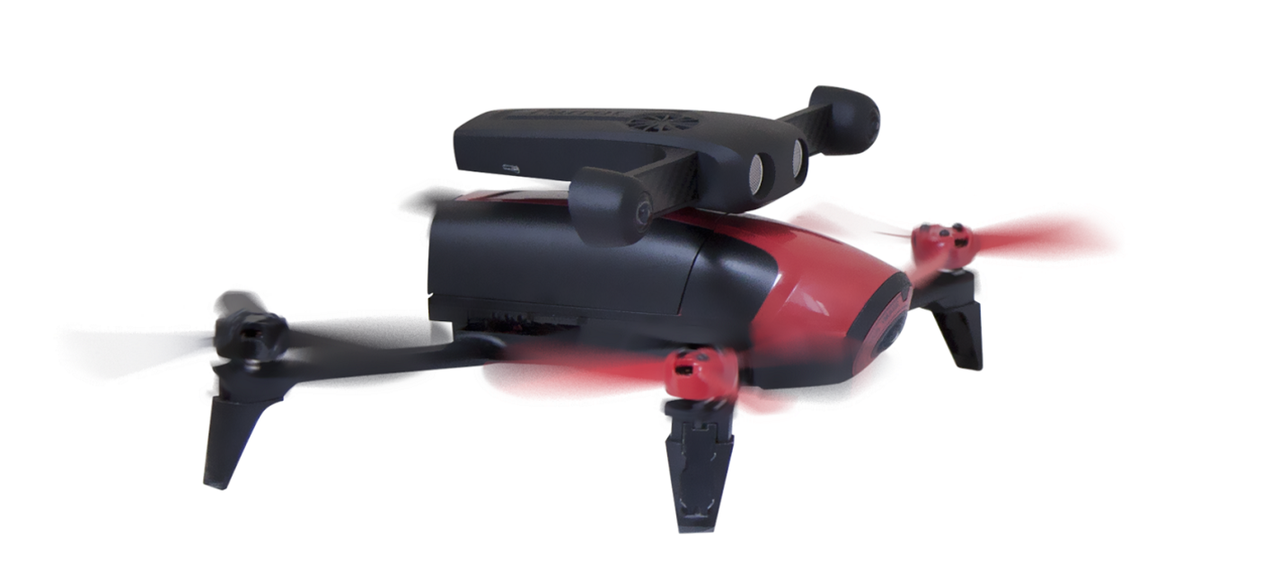
Parrot collaborates with Canonical to launch the Parrot S.L.A.M.dunk, a new development kit for the creation of autonomous and obstacle avoidance drones and robots. Powered by Ubuntu and ROS (Robot Operating System), it gives developers a familiar environment to prototype solutions such as autonomous driving, 3D mapping, or simply using the on board stereo camera and sensors for data gathering.

Just attach the Parrot S.L.A.M.dunk to a drone, plug it into the power source and flight controller and you’ve transformed your drone into an intelligent robot.

Screen-Shot-2016-09-07-at-10.32.09.png?width=600

The Parrot S.L.A.M.dunk is particularly suited to an environment with no GPS or numerous obstacles where its S.L.A.M. (Simultaneous Localization and Mapping) software can be used to help the drone understand and navigate its environment.

With support for Ubuntu and ROS, it uses the most popular and versatile robotic development environment. This means that whilst drones are the primary market for the Parrot S.L.A.M.dunk, it can be used for a much wider set of “robots”, flying wings, articulated arms and roving robots amongst others. Ubuntu and ROS are the preferred choices for robotics developers and researchers, explaining why Parrot decided to choose to offer the combination as a key component of their development kit.

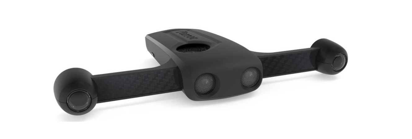
From a hardware point of view, the Parrot S.L.A.M.dunk packs an impressive spec into just 140g, including:

  • NVIDIA Tegra K1
  • Fish-eye stereo camera with a 1500×1500 resolution at 60fps
  • Inertial-measurement unit (IMU)
  • Ultrasound sensor
  • Magnetometer
  • Barometer


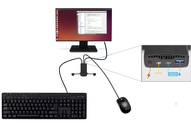
To top off the list, the Parrot S.L.A.M.dunk boasts a HDMI port… just plug it into a screen and you’ll get one of the oddest shaped Ubuntu 14.04 computer you can find! Being able to run an Ubuntu desktop directly from the device is a great way for developers to do quick iterative development directly on the board and test their results literally on the fly.

unnamed

Screen-Shot-2016-09-07-at-10.32.28.png?width=700

Parrot collaborates with Canonical to launch the Parrot S.L.A.M.dunk, a new development kit for the creation of autonomous and obstacle avoidance drones and robots. Powered by Ubuntu and ROS (Robot Operating System), it gives developers a familiar environment to prototype solutions such as autonomous driving, 3D mapping, or simply using the on board stereo camera and sensors for data gathering.

Just attach the Parrot S.L.A.M.dunk to a drone, plug it into the power source and flight controller and you’ve transformed your drone into an intelligent robot.

Screen Shot 2016-09-07 at 10.32.09

The Parrot S.L.A.M.dunk is particularly suited to an environment with no GPS or numerous obstacles where its S.L.A.M. (Simultaneous Localization and Mapping) software can be used to help the drone understand and navigate its environment.

With support for Ubuntu and ROS, it uses the most popular and versatile robotic development environment. This means that whilst drones are the primary market for the Parrot S.L.A.M.dunk, it can be used for a much wider set of “robots”, flying wings, articulated arms and roving robots amongst others. Ubuntu and ROS are the preferred choices for robotics developers and researchers, explaining why Parrot decided to choose to offer the combination as a key component of their development kit.

From a hardware point of view, the Parrot S.L.A.M.dunk packs an impressive spec into just 140g, including:

  • NVIDIA Tegra K1
  • Fish-eye stereo camera with a 1500×1500 resolution at 60fps
  • Inertial-measurement unit (IMU)
  • Ultrasound sensor
  • Magnetometer
  • Barometer


To top off the list, the Parrot S.L.A.M.dunk boasts a HDMI port… just plug it into a screen and you’ll get one of the oddest shaped Ubuntu 14.04 computer you can find! Being able to run an Ubuntu desktop directly from the device is a great way for developers to do quick iterative development directly on the board and test their results literally on the fly.

unnamed

Read more…
3D Robotics

3689699815?profile=original

From Aerobugs, an interesting use of a Pixhawk-powered hex to drop "preferential insects" on crops:

The brainchild of Nathan Roy, Aerobugs is a commercial UAV operation licensed by Australia’s Civil Aviation Safety Authority (CASA) to distribute preferential insects from the air over a variety of crops. These bugs, through their natural life cycle, kill pests that can destroy a number of crops including strawberry, tomato, brussel sprouts, pears and more.

The use of preferential insects to kill pests in crop production has been used for decades and is constantly being researched by Australia’s CSIRO. Normally insects are distributed by hand, either by walking or from a quad bike. This practice is slow and labour intensive, especially when considering tens of hectares or larger.

Starting out his business life as a 3rd generation strawberry famer, Nathan made the switch to UAV’s after losing 700 tons of strawberry crop to rain and weather damage. With the extended family switching to turf farming, Nathan decided to explore his interest in UAV’s to see if he could forge a business from his hobby.

Ordering his first UAV frame from eBay while sitting in the cab of his tractor, Nathan wondered if the spreading of preferential insects, a job normally done by hand on his farm, could be better managed from a suitably designed and built UAV.

 A true family business start-up, it was not long before Nathan’s wife, Amanda’s kitchen was full of UAV frames, motors and speed controllers. In fact, Amanda quickly picked up the job of designing and making the bag that would hold the insects and allow for a smooth distribution flow. Amanda produced seven or eight iterations of the design before settling on a design that seemed to work best for the initial commercial applications.

Meanwhile Nathan got busy on designing his now patented spreader. Mounted at the bottom of the bag the spreader produces an even distribution with very low insect mortality rates. The prop wash from Nathans home built, eight propeller UAV helps to make sure the insects penetrate deep into the crop foliage.

AAEAAQAAAAAAAAl5AAAAJDhmYmYyZjk4LWZkZmYtNDUzYy1hNmQ5LWU1NzAxMDQ4OTNkMA.jpg

It was not all fun and playing with toys. Nathan had to negotiate the brand new playground of aviation regulation. Working closely with CASA to make sure he himself met all the requirements of a UAV commercial pilot, he then had to convince them that dropping insects from the sky was a perfectly acceptable use of UAV technology.

It took some support from the Bio Security division of Australia’s Department of Agriculture and Water Resources to help CASA understand what Nathan was doing. It was a two-year process to secure all the needed paperwork but then Nathan was something of a pioneer, and he remains one of CASA’s only UAV operations regulated to perform such tasks.

Nathan received a shock when CASA sent seven personnel to his flight test to receive his commercial UAV licence. It turned out however they just wanted as many CASA field staff to learn as much as they could to try to keep ahead of the UAV and RPA growth curve. Nathan passed with flying (pun intended) colours.

With hundreds of hours of testing and 12 months of application on a tomato farm with resounding success, Nathan began to grow his commercial preferential insects’ application business.

Operations

Aerobugs sources the preferential insects from Bugs for Bugs Pty Ltd based in Mundubbera, QLD. They have worked closely with Nathan from the start, and their field scouts conduct post application inspections to check the quality of the spread, mortality rates and to capture vital data, not only for cross checking with Nathan but for their own business and data analysis also.

The insects are mixed with a vermiculite medium so they have something to cling to, and so they fall cleanly below the UAV. Nathan has determined that a sweet spot of about 5 metres of altitude works best for an even distribution and so any breeze will not move the bugs too far from the UAV. Like any aerial application technique, Nathan uses the wind to his advantage as long as it is not too strong and positions the UAV accordingly as he manoeuvres along the rows.

Common pests include the Red Spider Mite or Two Spotted Mite and can affect hundreds of vegetable and food crops. A common insect that Aerobugs distributes to counteract these is the Preditor Mite (Phytoseiulus Persimillis) as they break the life cycle. Trichogramma wasps are also used to protect tomato crops.

Every job requires two people on site to manage the flight and keep the area safe. Even though the area is marked with signs stating there are low-level aerial operations in progress, people still love to walk across a paddock or up a dirt road to look at what s going on. At this point, the UAV is returned to the operator and parked in hover until the offending onlookers are clear of the area.

Australia wide Nathan has six cross-trained pilots who can operate as observers or pilots when he needs them. All flying is done manually for now as the autopilot software available for many UAVs is not quick enough at correcting for sudden wind gusts and altitude changes. Through plenty of experimentation, Nathan finds hand flying to be the most reliable for now.

The Machines

Nathan builds the UAV’s himself and there are six in the fleet. There have been many iterations along the way to perfect flight times with payload and reliability. These are not your average weekend hobby machines. They are expected to operate for hours a day over several days to keep up with demand. Flight times per battery charge average about 18 minutes.

Many of the required items are sourced from Foxtech. Nathan has tried many motors but has settled on the Foxtech 380KV motors as they provide hundreds of hours of reliability. Apart from the odd bearing change, his motors see over 450 hours regularly. Frames, props and his Foxtech 145G remote control are also sourced from Foxtech. The US Pixhawk with Mission Planner does flight control duties and the motor speed controllers come from Hobbywing.

The Aerobugs UAV’s are agriculture machines built to be strong, reliable and maintainable.

AAEAAQAAAAAAAAgVAAAAJDEwMzM5ZGY3LWM1ZTItNDA4NC1hNzJmLTU3ZGM5YzU3ZmE3MQ.jpg

Regulation

The CASA environment at the time Nathan was putting all this together was still trying to grasp the realities of the speed of innovation. However, they have been very supportive in all respects even if it did take a few phone calls and meetings to work through all the issues.

With the help of RPV Australia, Nathan received his qualifications. Having to sit the Basic Aeronautical Knowledge (BAK) test, which discussed, amongst other things how to deal with carburettor icing in piston-powered aircraft was something of a curiosity, but Nathan persevered. Nathan is not the only one who thinks CASA can make some changes there.

Keeping the Aerobugs’ operations manual up to date with new designs and refining systems and processes for each type of crop operation keep Nathan and Amanda busy in between jobs. However, it has been worth it.

Aerobugs is leading the way in the application of preferential insects but is also paving the way for many other types of application processes in cropping.

Nathan can be contacted at www.aerobugs.com.au and for some video and the latest Aerobugs action visit their Facebook page at https://www.facebook.com/aerobugs/

Read more…

3689699697?profile=original

Please find here the World Bank's official Call for Interest to field-test UAVs for a range of humanitarian applications in the Asia Pacific. Given that I'm part of the WB Team that is organizing and evaluating these field tests, I am not in position to reply to any questions related to this call for interest. Please follow the guidelines in the link above should you have any questions and note that the new deadline is Sept 26th.

Thank you!


Read more…

Combined with Intel’s Existing Assets, Movidius Technology – for New Devices Like Drones, Robots, Virtual Reality Headsets and More – Positions Intel to Lead in Providing Computer Vision and Deep Learning Solutions from the Device to the Cloud

Computer vision is a critical technology for smart, connected devices of the future. (Credit: Intel Corporation)

Source:https://newsroom.intel.com/editorials/josh-walden-intel-editorial/

With the introduction of RealSense™ depth-sensing cameras, Intel brought groundbreaking technology that allowed devices to “see” the world in three dimensions. To amplify this paradigm shift, they completed several acquisitions in machine learning, deep learning andcognitive computing to build a suite of capabilities that open an entirely new world of possibilities: from recognizing objects, to understanding scenes; from authentication to tracking and navigating. This said, as devices become smarter and more distributed specific System on a Chip (SoC) attributes will be paramount to giving human-like sight to the 50 billion connected devices that are projected by 2020.

With Movidius, Intel gains low-power, high-performance SoC platforms for accelerating computer vision applications. Additionally, this acquisition brings algorithms tuned for deep learning, depth processing, navigation and mapping, and natural interactions, as well as broad expertise in embedded computer vision and machine intelligence. Movidius’ technology optimizes, enhances and brings RealSense™ capabilities to fruition.

We see massive potential for Movidius to accelerate our initiatives in new and emerging technologies. The ability to track, navigate, map and recognize both scenes and objects using Movidius’ low-power and high-performance SoCs opens opportunities in areas where heat, battery life and form factors are key. Specifically, we will look to deploy the technology across our efforts in augmented, virtual and merged reality (AR/VR/MR), drones, robotics, digital security cameras and beyond. Movidius’ market-leading family of computer vision SoCs complements Intel’s RealSense™ offerings in addition to our broader IP and product roadmap.

Computer vision will trigger a Cambrian explosion of compute, with Intel at the forefront of this new wave of computing, enabled by RealSense™ in conjunction with Movidius and our full suite of perceptual computing technologies.

Read more…