All Posts (11086)

Sort by

3689696739?profile=original
Last week we revealed the newest addition to UgCS family of ground control software - UgCS Drone Dance Controller. UgCS DDC allows the simultaneous and synchronized control of up to dozens of drones. It can be used to create spectacular shows using drones. Together with that we published a video showing the operation of 20 drones with UgCS DDC where the drones were simulated using SITL.

A few of you asked about real-world flight, so here it is. For this flight we took the five Pixhawk drones we had in our fleet and went out into the field. Both of the IRIS drones were using 3DR telemetry radios for communication while the other three used Wi-Fi modules. Here is the result:


For more information about and downloads of UgCS ground control software please visit www.ugcs.com

For inquiries regarding UgCS DDC please contact us at ugcs@ugcs.com

Safe flights,
UgCS Team

Read more…

Flush Airdata Sensing

Figure 1 Flush Airdata Sensing

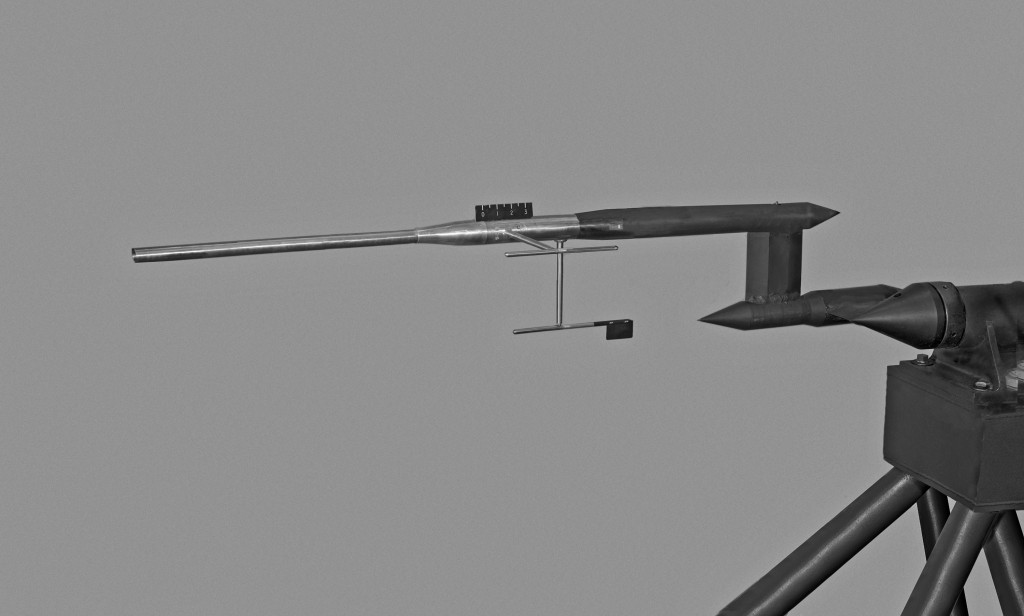
Figure 1:  Mechanical Air Data Boom tested in 4x4 tunnel

Air data can be acquired by mean of mechanical probes protruding from the airframe. In many cases was also possible to find a placement for the probe that is out of the body modified airfield. Very common is the nose mounted air data boom. In Figure 1 you find one mechanical air data boom tested within a wind tunnel in 1958 (Source: NASA).

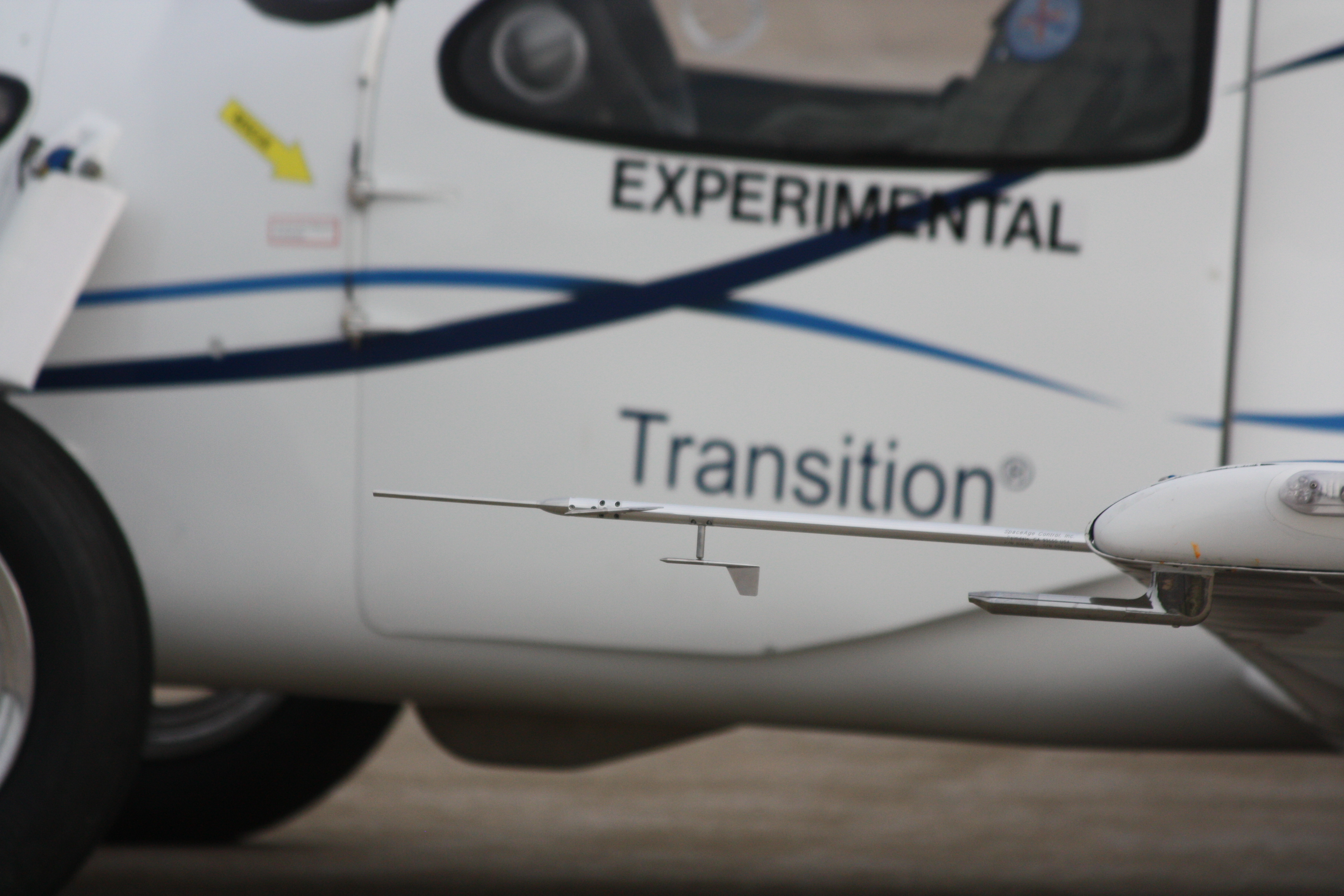
Mechanical Air Data Booms are able to reach a notable degree of accuracy and are used in some modern applications, you see a miniature mechanical Air Data Boom mounted on the Terrafugia prototype in Figure 2.

Figure 2 Flush Airdata SensingFigure 2: SpaceAge Control miniature 100400 Air Data Boom

Apart the weight and the size, this solution should deal with its intrinsic mechanical nature, mechanical-friction, inertia and robustness consideration are of high impact on overall probe design and performances. Mechanical related problems are exalted in both at low and high airspeed. At low airspeed, we have a low aerodynamic force to win the wind vanes frictions. At high airspeed, the aerodynamic damp of the wind vane will decrease and can lead to an unacceptable dynamic behavior. Anyway, an alternative to the classical probes is to reconstruct wind direction using multiple pressure readings. That defines two big families of probes the first is the so-called Multi Holes Probes and the second the Flush Airdata Sensors.

Figure 3 Aeroprobe-Micro-ADC Flush Airdata SensingFigure 3: Aeroprobe ADC with 6 holes MHP

With a classical probe, the information on wind direction is available directly from the two wind vanes angular sensors signal, in a pressure based system that information should be reconstructed from different pressure readings. Refer for example to the commercial MHP of Figure 3. On this probe tip, there are presents six different pressure ports. There is a central hole that can give exactly the same pressure reading of that measured by the total pressure hole of a Pitot-Static probe. There is an annular pressure port, at a certain distance from the probe tip, that measures the static pressure; in a similar way of the Pitot-Static probe static port. There are 4 supplementary holes on the probe head. They can be used, for example, but not only, in couples to determine the angle of attack and the angle of sideslip. Data reduction algorithms can use the combined data from all the six pressure taps to reconstruct

\(P_t\) Total pressure or impact pressure
\(P_s\) Static pressure
\(\alpha\) Angle of attack
\(\beta\) Angle of sideslip

The pressure at ports is correlated to the relative wind magnitude and direction, you find a developed example of the angle of attack measurement case in this link. This kind of probes is used usually in many research and industry fields, including turbomachinery. MHP probes can reach dimensions under the 6 mm diameter.

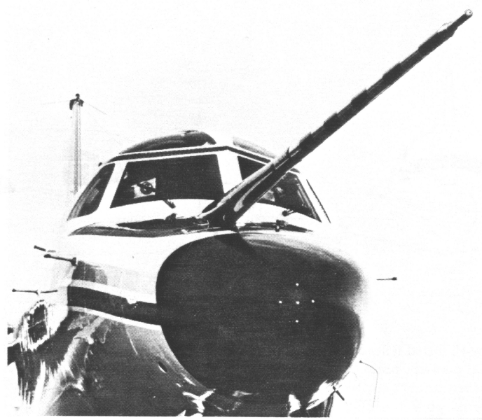
FADS are similar under many aspects to MHP but the probe surface is usually one airframe surface exposed directly to the air stream. In many cases, the sensor openings are over a modified nose cone. Refer to Figure 4, here you find a FADS system; description of the system here.

FIGURE 4 b23_f3-1a Flush Airdata Sensing
Figure 4:  NCAR Sabreliner aircraft equipped with both the differential pressure probe and the radome with pressure ports

This kind of probe is commonly used in research applications. Many studies were conducted by Langley NASA research center for the shuttle space program [page 6]. Dryden Flight Research center continued the work and produced different interesting articles. You can find notable information within this NASA work or in this work on X-33 FADS. Regarding real time data reduction consideration please consider that other article.

Both the families of probes can reach notable performances. Calibration, both aerodynamic and of single pressure sensors, and reduction algorithms for the FADS can pose a more that respectable practical problem. I've no notice, to date, of any DIY probe of that kind. It is to be noted that DIY aircraft have reduced flight speeds, that signifies that magnitude of pressures measured or differential measured differential pressure is really of small value; for a medium demanding application, we may need to have pressure measurements accurate to about a Pa. It's clear that an extremely well-calibrated measurement hardware is needed. It seems neither easy nor cheap to go under one degree of overall accuracy on AOA measurement. As many users are interested in the topic we will develop it in time and publish the results online. For the same reason if you think you can contribute to development please enter in contact with us.

Read more…

Precis-BX305 Quick Start Guide Released

3689696714?profile=original

Welcome to the Precis-BX305 Quick Start Guide. Here you will find instructions for how to use the Precis-BX305 RTK board in some simple steps with illustration. Of course, more details of its application could be found in Precis-BX305 User Guide.

We are also glad to share with you that Tersus GNSS Center V1.0, which is the official configuration software for all Precis RTK boards is available now. It is a PC tool to help users configure the RTK board and visualize running status. The Quick Start Guide of this software is on the way. Stay tuned.

To download the Precis-BX305 Quick Start Guide and Tersus GNSS Center, please visit www.tersus-gnss.com/pages/document-software or contact us at info@tersus-gnss.com.

Read more…

PX4, aerial 16x zoom lens Walkera Voyager 4

An update and sneak peek at the Walkera Voyager 4, after a long year of development, flight controller PX4.

Voyager 4 is a unique fusion of both aerodynamics and aerial video technology running on‬ 2.4 gHz or 4G LTE with Apple IOS App.  Expanding the range as far as you can, as long as you have 4G mobile network.

source: http://youtube.com/diydrone

Read more…

"Wing Board" using Pixhawk and GCS...

3689696644?profile=originalFrom Gizmag:

What started as a 1/6th scale model and an audacious (and ultimately doomed) Kickstarter campaign less than two years ago, has progressed to something people can actually strap into and ride. Well, not just any people. For its first foray into wind tunnel testing of its full-scale WingBoard, Wyp Aviation turned to Brandon Mikesell, a wingsuit-wearing maniac who spends his days leaping off mountains and gliding through majestic valleys.

Crafting the full-scale WingBoard prototype began with blue structural foam, which was then coated with layers of fiberglass and carbon fiber, incorporating plywood ribs to help distribute the loads. The prototype is broken down into five sections and assembled by joining each together with carbon fiber tubes. Flight control is handled by commercial and RC aircraft servos, with an autopilot function used to keep the wings level.

The testing took place over two days at the Ontario Institute of Technology's ACE (Automotive Centre of Excellence) wind tunnel, where the WingBoard was subjected to flight speeds of 55 to 75 mph (88 to 120 km/h). The testing was designed so that the WingBoard would feel the same forces as it if was being towed along by an aircraft, with a Y-shaped tow line harness connected to a point around 45 ft (13 m) inside the wind tunnel contraction.

The team evaluated the board's performance over four hours of flight and found that it behaved as hoped, with takeoff speed within 5 mph (8 km/h) of predictions and the drag forces within 10 lb ((4.53 kg). Most of the testing was carried out by Mikesell, but part of the exercise was also to get an idea of how easily beginners can learn to fly the WingBoard.

To this end, a member of the team with no skydiving but a little wakeboarding experience was ushered onto the WingBoard to gauge the learning curve. With guidance from Mikesell, the novice WingBoarder learnt to fly smoothly within 15 minutes of strapping in, noting the easy transition between wakeboarding and its nascent aerial counterpart.

"This has been an unqualified success, we could not have hoped for this to go any better than it did over the last two days," says Wypyszynski. "We hit everything we ever hoped we could, it actually got to the point that after the first couple of tests we sat there and were like 'Well now what do we do, it's going so well, what else can we get out of the test today, how much more can we figure out?' and really got a lot further than we thought we would get."

From here, the team plans to move onto real world testing behind real world aircraft in the real world sky. This next stage will play out across a few phases, beginning with helicopters without tail rotors, such as the MD-500 NOTAR or K-Max. A standard tow plane, such as a Piper Pawnee, will follow, which will allow the team to test out the takeoff and landing techniques.

These bookends to the WingBoarding experience are elements that Wypyszynski has put a fair bit of thought into. He ruled out the idea of having the rider dispatched from the aircraft when it is already airborne due to stability issues. Instead, riders will take to the skies the same way as a glider, with the board towed along in a rolling takeoff. Landing can play out a couple of ways, with the rider either freeing themselves from the board and parachuting back down to Earth or through a rolling landing similar to the way they took off.

Assuming this part of the testing goes to plan, the team will move onto more aerobatic pursuits, using a suitable aircraft to engage in rolls, inverted passes and formation flying. These first flights behind aircraft are hoped to kick off later in 2016 or early 2017, before the team takes the WingBoard on tour around the airshow circuit. While the company hopes to eventually sell WingBoards to individuals, they are also looking to build facilities where daredevils can pay for a single-flight experience similar to a skydive, and apparently at not much more of a cost.

Read more…

3689696448?profile=original

This post first appeared in sUAS News 'The Market'

--

It may not seem like it, but drones are still in their infancy and only proving themselves through the rigorous testing done privately, commercially, and by state and federal government agencies. Despite the tangible benefits that drones can provide, the public has mixed sentiments about their use by law enforcement, firefighting, and search & rescue operations. 

As early as 2012, this AP-NCC poll found a third of the public fears that police using drones for surveillance will erode their privacy.  But negative sentiment is changing.  In 2013, an Institute for Homeland Security Solutions (IHSS) and RTI International survey found 57 percent of the general public supports the use of unmanned aircraft systems for any application. It found:

  • 88 percent of the general public supports drone use in search and rescue operations
  • 67 percent support drone use in homeland security missions
  • 63 percent support drone use in fighting crime

Nevertheless, despite fears by segments of the public and civil rights proponents like EPIC that broad use of drones heralds a domestic “surveillance state,” many more believe unmanned aircraft systems (UAS) provide tremendous benefits and dividends for public safety. This includes everything from traffic accident investigation, to forensics, to fire investigation and damage assessment.

With that in mind we just released our third research report series of studies that looks objectively at each major commercial market for drones and drone technology. This study titled “The Truth about Drones in Public Safety and First Responder Operations,” shows how drones have been used successfully by law enforcement, firefighters, and search & rescue thus far, reviews competitive and traditional approaches using incumbent technology, discusses the opportunities and challenges posed by regulations, outlines the lessons learned, and discusses what’s next for drones in this industry. Here is an excerpt:

“All these use cases are vital public safety matters that civilian market drones are well suited to handle. Cities, towns, and municipalities facing strained budgets and dwindling resources may more easily be able to afford small drones than traditional big ticket first response equipment and personnel. Consequently, drones will give some local governments a bigger bang for their buck.

But would-be adopters need to know that in the U.S., the Federal Aviation Authority (FAA) controls the skies and has created regulations (safety standards) governing the operation of aircraft. Thankfully, not all, but still some, of the Federal Aviation Regulations (“FARs”) apply to public aircraft. The FAA allows first responders with an FAA certificate of waiver the ability to create their own safety standards for the pilots, the aircraft, and maintenance. Additionally, first responders can choose to also operate under the newly created and liberal Part 107 small UAS regulations if that benefits their operations more.

In the U.S., it’s reported there are almost 18,000 state and local law enforcement agencies with at least one full-time officer or the equivalent in part-time officers.  That includes over 12,500 local police departments and over 3,000 sheriffs' offices, and 50 primary state law enforcement agencies. The National Fire Protection Association reports that in 2014, there was an estimated total of 29,980 fire departments, of which 19,915 (about two-third) were staffed only with volunteers.  Smaller law enforcement agencies and volunteer fire departments that have limited finances stand to benefit greatly because the price entry point has decreased for consumer drones (like the one pictured in Figure 3), their capabilities have increased, and the new liberal Part 107 regulations make it easier to legally operate.”

The report details major use cases and discusses the challenges and lessons learned by police and search & rescue teams including the lessons offered by Gene Robinson, head of Unmanned Aircraft Operations for the Wimberley Fire Department, from his work in the aftermath of the 2015 Texas Memorial Day floods.

You can get the free report here.

If you have questions about what's in the report or would like to comment on it after reading it, write me colin@droneanalyst.com.

Image courtesy of Gene Robinson
Read more…
100KM

The second prototype of the DeltaQuad was given to the PX4 team at ETH in Zurich. The DeltaQuad is a VTOL flying wing based on the Skywalker X8. It is currently under development at DronesLab and will be available soon.

The PX4 team has added the airframe to the Gazebo simulator and made this impressive video

The modifications made to the airframe put the CG exactly in the middle of the large payload area. That makes it very useful for cargo transport, arial mapping and other payload dependent tasks.

At DronesLab we're working hard towards a stable platform ready for production. The current prototypes are being tested for accurate performance, endurance and capacity statistics. The next prototypes will be equipped with custom wing joiners that house integrated connectors for fast assembly.

Stay tuned for more updates

Read more…
MR60

Hi,

This is a hardware review of an interesting product for FPV racers. I do not know for how long it exists but I could not find any other reviews on youtube.

This product consists in an integration of mutliple components you would otherwise need to solder and assemble together with lots of wiring, thus saving weight and making a cleaner build.

In brief, it is at the same time:

-a F3 flight controller board (could have been the latest F4 generation but hey, F3 is good enough for my flying skills). The F3 board plugs/unplugs from the ESCs/PDB motherboard. So it can be replaced if needed.

-a power distribution board

-a 5V BEC

-a 12V BEC

-4 in 1 20 amps BLHeli ESCs. Their signal+ground wires are connected to the F3 board within the PCB , so no wires required. All four ESCs can also be individually replaced if needed.

The video shows all positive and negative aspects I found about it. A big plus is the weight saving and ease of build. The biggest negative point is you are stuck with a rectangular form factor and the solder pads for the motor wires are not best placed for a typical FPV X frame.

Cheers

Hugues

Read more…

Hello there, 

Please take a look at our newest Pixhawk based mapping setup with Easy Drone XL Pro and Sony QX1 and an additional FPV camera for live video feedback. 

It takes advantage of a fairly large format imager on this cool Sony camera and gives you the ability to use high quality prime lenses. This rig will stay in the air for solid 30 minutes and can cover a large area. Because QX1 doesn't have a video out, we've added a small, light FPV camera that transmits live video down to the monitor. 

3689696466?profile=original

This new setup has a 30% better GPS accuracy because we are using the new NEO-M8N receiver that works with multiple networks concurrently. Needless to say it still fits in the same small backpack due to our modular design.

3689696534?profile=original 

And to make things more interesting it comes ready for our GlobalARC system that provides unlimited distance telemetry over GSM networks and you can access all data and video online at www.globalarc.us;

Please let us know your thoughts!


Easy Aerial Team 

www.easyaerial.com / www.globalarc.us

Read more…

3689696507?profile=original

As the popularity and availability of drones increases so do the ideas for applications. One such application is the use of drones for entertainment shows. While flying a pack of drones with synchronized moves in the air is no easy task, it can produce a truly stunning view, especially if the drones are equipped with LED lights or other show elements.

For this purpose we have created UgCS DDC - UgCS Drone Dance Controller. UgCS DDC is a version of UgCS ground control software for drones that is custom-built for use in drone shows. It is capable of handling the simultaneous and synchronized control of dozens of drones.

In addition to the standard UgCS client and Service manager, it also features a DDC client. Through the DDC client it is possible to view the status of all your drones and send commands to them simultaneously. It is also possible to group the drones and send commands to a certain group of drones or even a specific drone.

UgCS DDC is currently the only commercially available software for drone shows to plan routes and execute them. It is offered as an additional paid option to our Enterprise version.

To find out more about UgCS ground control software for drones visit: www.ugcs.com

For inquiries regarding UgCS DDC please contact us at ugcs@ugcs.com

Read more…
3D Robotics

First Pixhawk-based drone company to IPO

3689696379?profile=original

AgEagle, which makes a Pixhawk-powered plane for agriculture inspection (see above; full video below), is going public on NASDAQ. From sUASNews:

AgEagle Aerial Systems is set to list on the NASDAQ stock exchange this week Thursday, 21 July. The Neodesha, Kansas-based company is planning to raise around $15 million in its Initial Public Offering (IPO) by offering 2.7 million shares at between $5 and $6 per share and will list under the stock symbol NASDAQ:UAVS.

In 2015, according to the company’s financials filed with the US Securities and Exchange Commission (SEC), AgEagle showed an annual net loss of $1.4 million on revenues of $774,000 after showing a profit of $200,000 on higher revenues of $885,000 the year before.

AgEagle designs and manufactures data-acquisition drones for precision agriculture and according to AgEagle’s website,

“AgEagle was a cooperative effort between founder Bret Chilcott and Kansas State University.  In 2011, K-State was working to merge small radio controlled airplanes and near infrared photo image technology to determine crop health.  Bret and the professors soon realized that farmers would benefit from this effort and AgEagle was created to serve that market.

By 2012, Bret completed the first prototype of AgEagle and took the prototype throughout the corn belt meeting with farmers and agronomists to see if they thought the AgEagle could help them. Interest was extremely high and by the fall of 2013, the first AgEagle drone was sold. Since that time, the AgEagle company has continually grown with dealers now across the United States.  Scores of AgEagles have been sold in the US, Australia, Canada and Brazil.”

Read more…

3689696241?profile=original

The massive Mexican flag flying on the Cuauhtémoc at Halifax, Nova Scotia, Canada. (photo: Flitelab)

A new podcast, The WorkNotWork Show, recently launched on iTunes and the premier episode will be of interest both to would-be drone entrepreneurs and those already operating a drone business: we interview Mark Langille of Flitelab, a successful drone business based out of Halifax, Nova Scotia, Canada.

In the show we talk to Mark about how he got started, the ins-and-outs of getting past the early stages of establishing his business, the current challenges facing the industry as well as both the science and art of drone photography and video.  We also ask Mark for advice for others who are contemplating doing something similar.

The WorkNotWork Show is going to be a continuing series covering those who have managed to turn their passion into their profession in a variety of fields.  It is anticipated that a number of episodes will feature people and businesses focused on the use of drones in a variety of scenarios. Subscribing to The WorkNotWork Show is entirely free.

Read more…
Developer

3689696411?profile=original

Here is a preview of my current project, a flight controller with onboard OSD targetted mainly at ArduPlane. The Board incorporates an OSD for FPV similar to that in  https://www.youtube.com/watch?v=ybab6q70icI . The OSD video out also provides telemetry via the video start of frame to communicate position data to an Antenna tracker. (Ardupilot Code for the version in the video at https://github.com/kwikius/ardupilot/tree/quantracker_master )

The main application is smart thermal soaring, therefore the board is long and thin to fit in a small fuselage. The connectors face upwards so that they dont stick out sideways and access should be easy from above if for example installed in the fuselage bay cutout under the wing of a Glider style aircraft. The SD card is forward and on top for easy access.

The other feature of the board is that it has been designed to incorporate a Raspberry Pi Zero as a companion computer fitting neatly on the underside of the board as shown in the image below. The Raspberry PI has AV out and an aux avout has been added so that the FPV view can be switched to a view of the Raspberry PI display.

3689696424?profile=original

Though the board can be connected to work stand alone, it is also designed to work with my "sub hub" boards: http://diydrones.com/profiles/blogs/simple-distributed-flight-controller-network , which are designed to allow most electronics and sensors, gps, rc receiver etc to be placed into the wings of the plane, each wing being connected to the fuselage by one 4 way connector thus allowing smaller fuselages, simple assembly and also improving rf separation for GPS RC etc.

Read more…
Moderator

3689696278?profile=original

I normally don't like to post extremely short blogs that just link to another article, but I think this has been a long time coming. 

I can't say that I hope for severe charges/fines against the operator (at this time), but I do hope that we only have to put up with one more season of seeing this in the news every other day. 

LINK

"

A Foresthill man has been arrested on suspicion of interfering with firefighting operations during the recent Trailhead Fire by flying a drone over the fire, according to the California Department of Forestry and Fire Protection.

The presence of the drone forced Cal Fire to ground firefighting aircraft due to the risk of a collision.

Information posted on social media helped lead Cal Fire law enforcement officers to 57-year-old Eric Wamser. He was arrested Friday afternoon and booked into the Placer County jail.

This is the first arrest by Cal Fire law enforcement of a drone operator on suspicion of interfering with firefighting, according to a Cal Fire news release.

Over the past two years, fire officials say they have seen increasing numbers of hobby drones flying over wildfires and interfering with aerial firefighting operations.

Air tankers and firefighting helicopters fly at low altitudes to drop fire retardant and water. When drones fly in the same air space, fire officials are forced to pull back aircraft to prevent a collision. Fire officials stress that hobby drones should never be flown in or around fire areas.

Officials say Wamser’s actions delayed aerial firefighting on a fire burning in the steep canyon of the middle fork of the American River near Todd Valley.

The Trailhead Fire started June 28 and was reported 98 percent contained Saturday. It burned more than 5,600 acres and forced hundreds of residents in Placer and El Dorado counties to evacuate their homes.

Wamser is suspected of flying his hobby drone over the fire during the evening of June 28 to take video and photos, Cal Fire officials said.

“The Trailhead Fire was burning in such a remote area that our aircraft were critical to stopping the fire,” Chief George Morris III, Cal Fire’s Nevada-Yuba-Placer unit chief, said in a written statement. “Every minute we couldn’t fly our aircraft because of this drone, the fire was able to grow and do more damage.”

Read more…
3D Robotics

3689696333?profile=originalFull disclosure: I was one of the judges. Too many great entries -- it was hard to pick a winner. From Popular Science:

Zelator, by Alexey Medvedev of Omsk, Russia, which won first place in the Airbus Main Prize.

The contest, which got underway this spring, ultimately netted 425 submissions.

The drones had a length list of requirements, including a weight below 55 pounds, the ability to take off and land vertically, and a pusher propeller.

There were nine winning designs (three places in each of three categories), and in total they were awarded over $100,000.

The Zelator entry can be viewed here. It features a sleek cargo compartment, a powerful engine for forward thrust in flight, and four smaller rotors to provide vertical lift.

The SkyPac drone designed by Finn Yonkers of North Kingstown, Rhode Island won the cargo category. SkyPac features a versatile tubular body that can fit many different loads for many missions, as designed, including dropping life preservers for sea rescue. Finally, Frédéric Le Sciellour of Pont De L’Arn, France won the community category with his slick Thunderbird design, a very horizontal craft with a hidden storage compartment in the main body.

Read more…

Have Multi Rotors Killed the Helicopter?

I think not and am expecting a resurgence of the good old heli.

This article puts forward a lot of good arguments for the helicopter (all be it in baby terms) but do you think there is truth in these claims?

3689695968?profile=original

A new Chinese unmanned helicopter might be the industry’s first critical step to a functional aerial logistic platform in the near future. This unmanned helicopter, produced by Ziyan UAVexcelled its counterparts by its outstanding performance in load-bearing, safety and speed...

Full story here.

Read more…

3689696260?profile=original

Hi DIY Drones folks,

We’re excited to announce the launch of Parrot Education! In support of the academic drone revolution, Parrot Education will encourage students and educators to learn, teach, and innovate using drones and, in the big picture, help prepare a new generation for the rising multi-billion dollar commercial UAV industry. Here are some examples of what the program offers to schools, universities, and non-profit institutions:

  • Educational discounts
  • Multi-drone teaching bundles
  • Software applications
  • Curriculum partners
  • Educational news
  • Limited sponsorships

For more information on the offerings of Parrot Education or to become a collaborator, you can find us at edu.parrot.com.

3689696211?profile=original

Read more…
Moderator

VTOL Anaconda built for Tyler Perry

I built this VTOL Anaconda for Tyler Perry and the new TV Series, DRONED, which will air on July 22 at 6:00pm on the Science Channel.   

3689695940?profile=original

This plane was built from a Ready Made RC Anaconda.  This model has both front and rear flaps, which helped a lot when transitioning from hover to forward flight.  

The VTOL uses a Pixhawk with Arduplane 3.6.   The motor booms are carbon fiber and attach to the the existing twin booms using 3D Printed, Carbon/Epoxy reinforced parts.   

The vertical motors are T-Motor 3510 700kv with T-Motor Air ESC's.   For power I'm using a 16000ma MutiStar 4S battery. 

It hovers nicely at about 65% throttle in Q_Loiter mode and I got about 18 minutes endurance in copter mode only.  The longest flight combined VTOL/Airplane mode was about 24 minutes. (I only did 3 test flights in forward flight before delivering it to Tyler Perry)

I can post a couple of build pictures, but if you want video, you'll have to watch the show (all of the video is owned by the network.  

Tyler Perry is an RC airplane fanatic and has a private RC runway and a barn with hundreds of RC airplanes.  He was genuinely excited when we delivered this custom built airplane to him for the show.  You can see a preview clip of the Episode here: 

Tyler Perry Likes his new Ardupilot VTOL

3689695849?profile=original

3689696006?profile=original

Read more…

Marine Litter Mapping

3689695793?profile=original

Marine litter is a huge problem with lots of statistics that boggle the mind. Most people will also have heard of the North Pacific Gyre, or rather, the Great Pacific Garbage Patch. It occupies a relatively stationary area that is twice the size of Texas. What we are trying to do with The Plastic Drive is raise awareness about the problem and record data on beach litter in a scientifically useful way such that it can be fed into the relevant models (current understanding of how litter moves around at sea is still rather crude).

DSC_1110

To help put some method into the madness we are supported by Kayleigh Wyles from Plymouth Marine Laboratory and, from Imperial College, Michael Lange (HPC), Erik Van Sebille (Ocean Circulation), and Stefan Leutenegger (Dyson lab).

To increase coverage and efficiency we figured we could use drones to map beaches & strandlines and process the imagery with some of the fancy deep nets that are all the rage these days. Hence a plan was formed and a UK version of the drive planned late summer. To test the basic data collection workflow we bought a second hand Canon SX260 on eBay, installed CHDK, strapped it to a quad and started doing some flights. Data is processed with DroneDeploy. Every area we fly we also survey manually and that way build up some data and experience as to the kind of things you find and would want to detect from the imagery. We know the camera is not great but its cheap and good enough for a baseline.

20160605_142738

We've only just started with two outings so far, a third one planned. But as we are trying to raise awareness and get people involved I thought it useful to post here in case anybody has done similar things or wants to help out.

Full writeup can be found at: https://dirkgorissen.com/2016/07/12/marine-litter-mapping/ and you can follow progress @ThePlasticDrive.

Read more…