All Posts (11086)

Sort by

1520-front-with-small-motor1.jpg

We are now shipping the RCbenchmark Series 1520. It measures overall efficiency, current, thrust, voltage, and motor speed. The device communicates with our open-source software, which displays and records data, and controls the motor manually or through a scripting system.


Whether you want to increase flight time for aerial photography, or performance for racing, the tool will help you obtain the data you need on your motors, propellers, ESCs, servos and batteries quickly and accurately.


A year ago, I posted here asking if people would be interested in a low cost, automated thrust stand. My colleague and I, both recent graduate from M.Sc. Mech. Eng., developed the Series 1580 dynamometer, and we obtained excellent feedback from a large number of businesses and universities. Many hobbyists asked us for a simpler, more affordable tool. We heard you, and we are now offering the Series 1520 for $165.

series1520back.jpg

Get it at $149 if you order before March 1st! Additionally, for a limited time, we will refund an additional $40 if you post a video review about our tool, which will lower the product’s price to only $109. Check the product page to see if the offer is still valid.

Here are the specs:

  • Voltage (0-35 V)

  • Current (40A continuous, 50A burst)

  • Power (0-1400W)

  • Thrust (±5 kg)

  • Motor speed (100k RPM)

  • Overall efficiency (%)

  • USB interface

  • ESC manual control

  • Three servo control ports

  • Output data to CSV files

  • Real-time sensor plots

  • Automated tests and recording

  • Powerful scripting abilities

  • Safety cutoffs


We want to offer more than a test tool. You might also be interested in our ongoing video tutorial series on motor and propeller theory. For more more information, check out our website or the Series 1520 product page. I will be available here to answer questions on our tools and on motor and propeller testing.


Read more…

UgCS - A Safe Platform For Unmanned Flights

3689682054?profile=original


It is well known that drones, along with other aircraft, possess a certain safety risk when operated. This potential safety hazard of drones has been highlighted in the media many times. Oftentimes this serves as bad publicity for companies and individuals seeking to use drones to benefit the public. When it comes to automated mission planning for drones, there are steps one can take to ensure that there are as many safeguards in place as possible. Not only does this make it safer for the operator, but it also increases the feeling of safety for the public.


UgCS has been developed with flight safety in mind. UgCS comes with several in-built safeguards. These are some of them.


In-built no-fly zones

3689682024?profile=original

UgCS comes out of the box with in-built no-fly zones around all major airports as well as the ability to create your own custom no-fly zones. This allows the operator to be sure that the flights are within legal distances from airports. Furthermore, if a part of the route intersects the no-fly zone, the route is calculated in a way so that the waypoints are placed around the no-fly zone.


Return home action

3689681921?profile=original

In addition to the return home switch on your remote, UgCS offers return home command through an action button on the screen. Moreover, the home location can be configured to either be in a specific point or in the first waypoint in the mission.

Fail-safe actions

In UgCS you are able to configure fail-safes on what your drone should do in case of GPS loss, radio communication loss or low battery level.


Configurable drone parameters

3689682067?profile=original


When each mission is calculated in UgCS, the approximated flight time of the mission is shown. Each drone has a configurable maximum flight time. In case the approximated flight time exceeds the maximum flight time for the drone, the mission is not processed.

In a similar fashion each drone type has adjustable battery voltage levels, GPS satellite levels and telemetry levels, meaning that once it gets below the threshold, a warning is displayed in the flight data window.

ADS-B

UgCS supports ADS-B receivers. These can be plugged into the USB port of the computer and will then be recognized. We can recommend microADSB-USB devices. In case your drone gets too close to a flying aircraft with ADS-B transponder, you will get a proximity warning in UgCS.


In addition to that, UgCS supports drones which are equipped with onboard ADS-B transponders. setup, through UgCS you are able to set ICAO ID, Flight ID and SQUAWK Code.

Terrain and building import

3689682048?profile=original

In UgCS you can import your own 3D models of buildings and terrain elevation profiles for places where the default Google terrain elevation is not precise enough. You can use these models to make your flight plans more precise.

To find out more about these features yourself, download the latest version of UgCS.

Get it here: www.ugcs.com

Safe flights,
UgCS Team

Read more…
3D Robotics

3689681995?profile=original

From uAvionix: 

uAvionix Corporation, the leader in unmanned ADS-B technology and Dronecode, the nonprofit organization developing a common, shared open source platform for Unmanned Aerial Vehicles (UAVs), today announced a plan to collaborate on advanced development in ADS-B ‘sense and avoid’ functionality in ArduPilot-based drones.

The uAvionix Ping is the smallest and lightest ADS-B transponder available for unmanned aircraft. At only 6gr it is able to detect all aircraft threats within a 30 statue mile radius in real time. The MAVlink based communication protocol found throughout the ArduPilot/APM autopilot line provides a plug-n-play integration of the uAvionix Ping transponder. The partnership will allow opportunities and new ways of combining the technical knowledge and inventive spirit of the two leaders in their respective fields.

“Being able to access the Dronecode application ecosystem will provide huge advancements in real-time sense and avoid behavior,” said Adam Paugh, uAvionix’ Director of Business Development. “This collaboration in open source ArduPilot-based development with standardized protocols, such as MAVLink, will accelerate deployable solutions for agile and reliable operation in the national airspace.”

The open source platform has been adopted by many organizations on the forefront of drone technology, including 3DRobotics, Parrot, Qualcomm, Intel, DroneDeploy, Yuneec, Airphrame, and others. With over 750,000 users and nearly 500 active developers it represents the largest community of UAV professionals and enthusiasts in the world today.

The alliance has identified project leads for three technical working groups to ensure development standardization and interoperability.

Andrew “Tridge” Tridgell – lead for ArduPlane
Randy MacKay – lead for ArduCopter
Craig Elder – technical manager for DroneCode

“The PING ADS-B receiver by uAvionix increases my flight safety by giving a sense and avoid capability that would allow me to avoid other full-scale aircraft,” said Airphrame’s Mechatronics Engineer Tom Pittenger. “That is a real concern that all drone companies should have so this is a must-have feature in the drone industry. It is an easy drop in feature to my ArduPilot based aircraft and ‘just works.'”

Read more…

3689681978?profile=original

Cobham have recently released their "Aviator 200 UAV" - a satellite datalink system specifically made for small UAV's.

Although you'll likely need deep pockets to afford one, it shows that the satellite communications industry has realised there is a market for small UAV's that require beyond-line-of-sight communications. As more manufacturers come onboard the competition should start driving the price down.

Specifications:

Weight: 1.45kg

Dimensions: 24x16x6cm

Datarate: up to 200kbps

Coverage: near-global (uses the INMARSAT-4 satellites). Does not cover the Arctic/Antarctic regions.

Power usage: 28W

By having this sort of technology, operating small UAV's over longer ranges become much more practical and safer, via the presence of a reliable and high-bandwidth datalink that is not range constrained.

Manufacturer's brochure: https://www.cobham.com/communications-and-connectivity/satcom/cockpit-and-cabin-communication/uav-satcom-systems/aviator-uav-200/aviator-uav-200-brochure/

Read more…
Developer

Ardupilot Flight Controller with on-chip OSD

Since my main interest is FPV, and I use an OSD, I was interested originally to make  a vector graphics replacement for MinimOSD. Here is the original diydrones discussion .  Though that worked well, I next decided to incorporate the Ardupilot code into the OSD so it is all integrated on the same IC.   The software and hardware is all Open Source. The Project is also different in using FreeRTOS rather than Nuttx or Posix  The source code is available on github

Above is the initial version. 

Currently I am designing a dedicated OSHW board for the project

Read more…

DronePilot - Position hold controller

We all love drones, and we love to just buy one and go outside and make it fly by itself, this is great. But what is actually going on inside the drone?

In this post I'm going to explain a bit how a loiter controller works, with the difference is that I'll show my controller, share the python code and that I'm using a motion capture system inside my lab. The great MAST Lab.

3689681952?profile=original

First things first, you can check the code here.  And secondly, I need to explain our setup. We are using Altax Flight Stack which is a tuple of computers connected with each other and sharing information. The flight controller is a very cheap naze32, running baseflight (but cleanflight will work as well), and the companion computer is a Raspberry Pi (any version will do the work...). The entire script does not consume too much CPU.

diagram.001

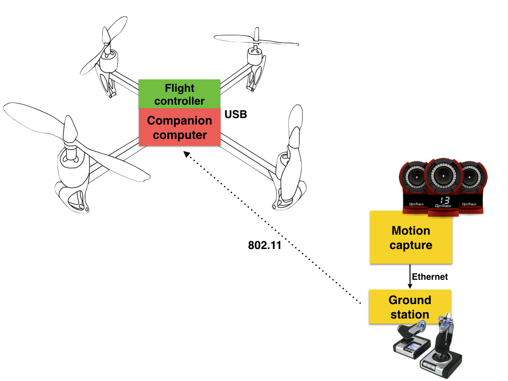
The connection diagram is showed above, the motion capture system is connected to a desktop computer and this computer sends the mocap data and the joystick information via a common wireless network (UDP), this information is used by the raspberry pi to know the position and attitude of the vehicle, then the rpi calculates a set of commands (roll angle, pitch angle, yaw rate and throttle) using simplistic PID controllers and then it sends the information to the flight controller.

This outer loop control is working at 100hz, but it can be configured to go slower.

Important to notice that we have crashed lots of times when starting to test/debug this system. Most of the crashes are due to the desktop computer "hanging out"... then the vehicle stops receiving the information and will keep the last command. A auto-landing feature is needed, this feature will be added on version 2.

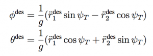
In the part of the control, we are using angle mode on the inner loop (naze32) and then we calculate the appropriate angle commands (pitch and roll) from desired accelerations (outputs of the controllers) to make the vehicle hold the commanded position in the space. The most important part of the code is when we calculate desired angle commands from the desired accelerations coming from the PID controllers:

desired-angles

And the proper math:

math

The rest of the code is just to deal with data, vehicle and make everything work on threads. One thread for the control and another for receiving the data. The code is extremely easy to understand and to tweak (I hope...). With this setup, the joystick is the one that activates the automatic behavior, if the proper switch is on manual, then you will be able to fly the vehicle using the joystick. This is by no means the same technique used by Pixhawk in loiter mode. But perhaps is a nice way to start learning about flight modes (and controlling aerial vehicles) so that then you can learn how advanced flight modes developed by the team of PX4 and ArduPilot work.

With a couple of changes, this same script and controllers should work with dronekit+pixhawk... I'll try that soon.

You can see the post here: http://altax.net/blog/hover-controller/

3689681844?profile=original

Read more…

Dear friends, I would like to introduce you the RTKite GNSS RTK L1+L2 module receiver.

3689681853?profile=original

http://northsurveying.com/index.php/instruments/gnss-rtk-receiver

Designed specifically for Pro and Semi-pro UAV, Robotics and Industrial applications, it connects directly to the Pixhawk and other autopilots and is specific for millimetric Photogrammetry, LIDAR Scans, Themography, etc.

The RTKite is a full Receiver (not a basic GNSS board) with an internal OS that can connect directly to standard CORS stations with its embedded GSM/GPRS cellular modem, can be configured and operated by Bluetooth, COM or TTL communications and can be set with our freeware for Android, Windows PC or WindCE or Linux, or even with text string commands.

It also can receive and transmit RTCM or CRM correction signals by UHF radio or our unique AutoCaster system that allows direct link connection by the integrated mobile modem with an stable transmission range of 75Km on Fixed position.

In is in fact a miniaturization of our professional surveying RTK receiver SmaRTK, (first generation released on 2012), and is compatible with our unique AutoCaster system for direct Base to Rover cellular data link.

Below, an Autocaster test on a modified DJI drone with Pixhawk and the RTKite GNSS with the lightweight helical antenna.3689681774?profile=original

3689681876?profile=original

3689681789?profile=original

Read more…
MR60

Sony QX10 mod for remote wire shutter trigger

The Sony QX10 is a nice lightweight 18 MegaPix camera for very little money (mine cost less than 100$ online, shipping included). It looks like a good one for aerial mapping missions. Unfortunately, it does not support USB cable remote triggering (unlike the much more expensive models in the QX family). Also, a smartphone app allows to trigger the camera via Wifi but that does not allow a direct shutter trigger control via Pixhawk, which was the purpose for getting this camera. Therefore I decided to modify my QX10 to see how trigger wires could be directly hacked on it...

Read more…
3D Robotics

3689681698?profile=original

ETH (home of Dronecode's PX4 project) is now leading the world in advanced drone tech. Just watch this amazing video...

Autonomous systems expert Raffaello D'Andrea develops flying machines, and his latest projects are pushing the boundaries of autonomous flight — from a flying wing that can hover and recover from disturbance to an eight-propeller craft that's ambivalent to orientation ... to a swarm of tiny coordinated micro-quadcopters. Prepare to be dazzled by a dreamy, swirling array of flying machines as they dance like fireflies above the TED stage.

Read more…
3D Robotics

rcform1side

From Hackaday:

[Daniel Norée] started the OpenR/C project back in 2012 when he bought a Thing-O-Matic. In search of a project to test out his new printer, he set his sights on a remote controlled car, which as he put it,”… seemed like the perfect candidate, as it presents a lot of challenges with somewhat intricate moving parts along with the need for a certain level of precision and durability.”

After releasing his second design, the OpenR/C Truggy, he realized a community was forming around this idea, and needed a place to communicate. So, he created a Google+ group. Today, the Truggy has been downloaded over 100,000 times and the Google group has over 5,000 members. It’s a very active community of RC and 3d printing enthusiasts who are testing the limits of what a 3d printer can do.

The latest design to come out of the OpenR/C project is the Formula 1 car. It’s really fun to browse through the Google Group and see all the upgrades people are coming up with. For example, [Thomas Palm] figured out a way to trick the slicer into printing little nubs on the outside of low profile tires for the F1 car. Want to drive your F1 Car in the snow, there are tires for that.

CrashedTruckDestructive testing lets OpenR/C iterate quickly.

For me the coolest part of the open RC project is the amount of testing going into materials and printing techniques. An RC car is light, super fast, and gets absolutely hammered by its environment. Since 3D printing lowers the cost of destructive testing so much, people are trying out and optimizing new designs and materials quickly.

If you’re willing to dig, the OpenR/C group has more tips on printing for strength, printing nylon, and printing flexible filaments than any other single resource on the internet right now. These guys are relentless.


OpenSwiftOpenSwift build in progress.

The project isn’t relegated to the road. People are trying out new flying designs all the time, like this quadcopter project.

Fixed-wing flight builds are also popular. There’s Open Swift, a 3d printable RC airplane designed by [CircuitGrove] that was sponsored by PrintrBot. And since printers are larger now there’s one group posting their progress on an airplane where the entire wing is printed in one piece.

This goes well beyond the group. People are showing off their custom bodies built on the OpenR/C frame in all kinds of places. Just searching for OpenR/C on Thingiverse results in thousands of improvements, upgrades, and remixes; like thisOpenR/C tricycle. I’d like to see a boat and a hovercraft developed by the community next.

Build with the Experience of Others

If you’re looking to build one of these, the community is extremely helpful. There are full, updated BOMs, print settings, and material recommendations. There are even tips for getting specific brands of printers to work.

For the future it looks like the OpenR/C group will continue to see growth. The community is active and it’s moderators work hard to keep the discussion going. [Daniel] has just opened up a Facebook page as well for those who aren’t into Google+. It’s a really great example of what the future of making physical things will look like.

If you’d like to check it out:

Lastly, we’ll leave you with a small interview with [Daniel]:

How did OpenR/C get started?

It all started with me getting my first desktop 3D Printer, a MakerBot Thing-O-Matic. I wanted do a fun project that showcased what could be done on a Desktop 3D Printer. An R/C car seemed like the perfect candidate as it presents a lot of challenges with somewhat intricate moving parts along with the need of a certain level of precision and durability.

After releasing the second project, the Open R/C Truggy, it quickly became popular and to have a place where people could ask questions and share ideas. I decided to start a community on Google+ and so The OpenR/C Project was born…

What are the project’s goals and ethos?

Come to think of it I don’t think that I have ever had a “goal”. I just enjoy the possibilities given by having my own desktop 3D Printer, and the OpenR/C Project is just one of many ways to share with the world something I love to do. I hope the OpenR/C Project will inspire more people to get into 3D Printing, it doesn’t matter if it’s to 3D Print an OpenR/C project or just make something of your own. I want to share the feeling of enjoyment of being able to make digital objects come to life.
The project is based around the idea of sharing ideas with each others and having fun.

How long have you been working on it? Are you the project’s founder?

I started working on the first 3D printed OpenR/C car back in 2012. It’s not that long ago but it feels like such a long time ago because so much has happened since then.

I started the OpenR/C Project & Community early 2013.

How active is the community?

I’d say it’s active in that people are engaging the different projects all the time all over the world. Some like to share their work and progress, some ask questions and shares ideas and like to do their thing on their own. I’m so stoked to see so many people building these projects especially as I know it’s not always an easy task to build your own 3D Printed R/C car, Quad or other.

Where would you like to see it go?

It will be interesting to see what happens as the 3D Printers and materials in particular reach new levels. As precision and durability get better who knows what will happen! Of course it would be a dream to see the community get bigger and bigger and people still sharing their creations and knowledge with such an open spirit.

How can someone participate, and what is expected from them in the community?

You can go to my website www.danielnoree.com and check “Downloads” under which there there are links to a bunch of sites where you can download files for the OpenR/C projects.

If you want to participate, you can just download and build your own. You can improve or build upon existing projects, or create your own. Then all you need to do is to have fun, enjoy the ride and share your own work with the community.

The project really show’s what’s great about all these small revolutions in home manufacturing. It wasn’t too long ago that you could either pick excessive money or excessive labor as the way to build a custom R/C, or anything else like it. With printing and other methods lowering the barrier to entry and increasing the speed at which things can be made, many previously unthinkable projects are seeing the same quick iteration and design that personal computing brought to, well, computing.

Read more…
3D Robotics

3689681670?profile=original

If you've seen the Solo retail kiosks in stores like Best Buy, you will have noticed the cool built-in flight simulator that allowed you to use the Solo controller to virtually fly in a full 3D environment. We've now released a free and improved version of that for your own iOS and Android device, which is available now.  From the announcement:

To help new users learn how to fly without having to put their copter in the air — and to give all users the chance to hone their skills anytime, anywhere — 3DR has released the Solo flight simulator app. (It’s separate from the Solo app — get the simulator for iOS here, and Android here.) The app connects wirelessly from your mobile device to your controller, and the simulator’s responsiveness is mapped from the sticks to screen — the “sim Solo” on your screen responds to your control stick inputs just like the real thing would in the air.

In the simulator you can practice flying Solo freely, getting a feel for the flight controls as well as the camera controls without putting your investment in the air. It’s just like a video game: Your mobile screen displays the camera’s “first-person view” so you can get accustomed to seeing what Solo sees, using that to help guide your flight. Easter egg: There’s a passing speedboat. Can you land on it? (I don’t know if this is possible; I sure can’t do it.)

But perhaps best of all: You don’t need to be near the copter or even have Solo turned on to use the simulator; all you need is the app and the controller. Practice flying anywhere.

Download the Solo flight simulator app here:

Below is one the Solo retail kiosks that have been using the flight simulator since launch:
3689681711?profile=original
Read more…
3D Robotics

3689681398?profile=original

Oppenheimer, a Wall Street research firm, has just released a very good report on the current state and prospects for the drone market. One thing they point out is how all over the place most estimates of the market size are (see above). 

Here's another estimate, by the Consumer Technology Association (formerly the Consumer Electronics Association).  That's the one that feels most accurate to me. 

3689681613?profile=original

Read more…
3D Robotics

Drone registration proposal from Airmap

3689681634?profile=original

Airmap, a Dronecode Project member, has just released a very thoughtful and detailed White Paper on a proposed scalable registration system for drones. From the paper:

A robust and scalable registration system considers the right technologies for its organization, registration information, queries, and security as the UAS ecosystem expands. This paper argues that careful selection of current Internet technologies and protocols can help enable the creation of a registration system that serves present needs but will also evolve as technology advance

Read more…
3D Robotics

3689681385?profile=original

Amazing product from H3 Dynamics in Singapore. We've always dreamed of drones that could be deployed like sprinkler systems -- place and forget, and they just do their job, sending data to the cloud. Looks like we're almost there. 

From Gizmag:

The proliferation of drones for a multitude of tasks has led to improved autonomy, and reduced the level of human intervention. On the flip side, however, people are still needed to physically wrangle drones to a site whenever they are required, and much time and expense is spent deploying them. To help reduce this burden, the new Dronebox nesting platform has been created to provide 24/7 autonomous capabilities to drones. It provides an automated recharging and storage station that can be left on site so a dedicated Unmanned Aerial Vehicle (UAV) can be deployed on-call or routinely for many months at a time.

Touted by the makers as an all-inclusive, self-powered system that can be deployed anywhere, the Dronebox designed as a UAV solution to follow on from the likes of remote monitors and camera systems used today. As such, the creators envisage the replacement of these fixed monitoring methods with deploy-on-demand or programmed-cycle UAVs to provide a more flexible and intuitive way to keep an eye on things.

With batteries automatically charged within its shelter system using solar panels, the Dronebox can also be upgraded using a product known as Remobox to provide a small back-up fuel cell system to extend remote deployment for a year or more. The Remobox also provides add-on communications features and environmental monitoring to ensure a nested drone is operating in optimal conditions.

Dronebox also provides the ability to link drones and Droneboxes in a similar fashion to the Internet of Things (IoT), where varied and disparate devices are interconnected to collect and exchange data. In this way, arrays of wirelessly linked Droneboxes and their associated UAVs operate through a central hub, where all of their sensors are channeled through a unified analytics system to create what the makers call a "sensor fabric" that provides real-time, overall situational awareness of everything under surveillance.

As a connected network, Dronebox's effectiveness using collaborative technologies means that a UAV nested and deployed automatically could also offer a line of first response in forest fires, chemical spills, earthquakes, and other disasters before humans arrive. With multiple sets of drones monitoring all aspects of a catastrophe via the previously mentioned sensor fabric, the situation could be assessed and actions planned and resourced well ahead of any response, thereby saving what could amount to many critical hours of time on the ground for rescue teams, firefighters, and disaster recovery personnel.

3689681545?profile=original

The creators of Dronebox also believe that mobile sensors hosted in networked Droneboxes could help transform border and perimeter security, wildlife protection, critical infrastructure maintenance, telecommunications tower and wind turbine maintenance, oil and gas asset inspection, and precision agriculture.

On display for the first time at the Singapore Air Show this month, Droneboxes, Remoboxes, and their supporting technologies are slated for launch in the commercial marketplace some time within the next six months.

Read more…
Moderator

Chris Anderson to speak at sUSB Expo 2016

front16.ai_.png

Its the Silicon Valley Drone show time of year again http://www.susbexpo.com looking forward to meeting old friends and making new. The first commercial (all the rest were military/tiny bit of private before) drone show in America makes it to year four. 

Here's the line up so far.

Chris Anderson, CEO 3D Robotics founder DIY Drones

Chris is the CEO of 3D Robotics and founder of DIY Drones. From 2001 through 2012 he was the Editor in Chief of Wired Magazine. Before Wired he was with The Economist for seven years in London, Hong Kong and New York in various positions, ranging from Technology Editor to US Business Editor.

He is the author of the New York Times bestselling books The Long Tail and Free as well as the new Makers: The New Industrial Revolution.  In 2007 he was named in “Time 100,” the news magazine’s list of the 100 most influential men and women in the world. View Complete Bio…


Jeffery Antonelli

Jeffery Antonelli, Antonelli Law

Jeffrey Antonelli launched one of the first Drone/UAS Practice Groups in the country in 2014 after discovering drone technology in his RC aircraft hobby. The practice has now grown to more than 50 clients nationwide including billion dollar engineering, construction, and telecom concerns, GIS professionals, cinematographers, real estate companies, a news organization, and a forensic specialist. In addition to providing Section 333 and Public COA services, with the firm advises clients on complex aviation needs, digital privacy, tax, contracts, intellectual property, employment law and civil litigation. This is made possible in large part due to his co-counsel Kate Fletcher, attorney and pilot for the world’s largest airline; Washington DC regulatory and telecommunications attorney Mark Del Bianco; and aviation consultant Douglas Marshall. View Complete Bio…


Chambliss Headshot

Micahael Chambliss, International Cinematographers Guild

Michael Chambliss is a technologist and business representative for the for the International Cinematographers Guild (ICG), IATSE Local 600, focused on new production technologies impacting directors of photography and their camera crews. He has been working closely with FAA-exempt UAS motion picture and television aerial operators, regulatory agencies, insurers, the motion picture and television Industry Wide Safety Committee, industry guilds, and community based UAS groups to implement this technology as new visual storytelling technique. View Complete Bio…


Goksel_Dedeoglu_PercepTonic_BW

Goksel Dedoglu, PercepTonic

Goksel is the Founder and Lab Director of PercepTonic, his Dallas-based startup where he formulates embedded vision solutions for next-gen products. Thanks to the Robotics Institute at Carnegie Mellon and seven years with Texas Instruments’ R&D labs, Goksel is a recognized expert in Computer Vision with patents and product contributions in automotive safety, video analytics, face and gesture recognition, and augmented reality. View Complete Bio…

Gibson Marke (UAS AOA ADA) Bio Photo 0642_w_Flag (11-23-15) (2)

Marke F. Gibson Senior Advisor, Unmanned Aircraft Systems Integration

In September 2015, Marke Gibson joined the Federal Aviation Administration (FAA) as the Senior Advisor, Unmanned Aircraft Systems (UAS) Integration. He provides executive direction and high level leadership to the FAA with responsibility for oversight of the work related to UAS. In addition, he is responsible for developing and delivering business and strategic plans for enterprise-level UAS initiatives, analyzing integration progress, engaging in scientific and research activities, and maintaining liaison with internal and external stakeholders.
Prior to joining the FAA, Mr. Gibson served as the Executive Director of the NextGen Institute (NGI). The primary role of NGI is to provide a mechanism through which the private sector actively engages with the USG in defining, developing, and implementing NextGen. In that position, he promoted the NextGen Institute throughout the industry, created awareness and gained new support for NextGen initiatives. During his tenure at NGI, he led two UAS Spectrum working groups, an FAA Global Leadership Roundtable, and commenced work on an ADS-B initiative on behalf of the Deputy Administrator.View Complete Bio…


Heller Gregory

Heller Gregory, GrandView Services

Heller Gregory is the founder and president of Bay Area based GrandView Services, LLC. GrandView is one of Northern California’s first UAV companies focused on data acquisition and processing for civil engineering, geotechnical, heavy construction, and environmental monitoring. Ms. Gregory is a licensed private pilot who has been involved in digital imaging and communications for more than 25 years and with the civil, geotechnical, and earthwork construction industry for more than 20 years. View Complete Bio…

Heinonen Tero

Tero Heinonen, Sharper Shape, Finland

Tero, founder and CEO of Sharper Shape, is an entrepreneurial and experienced start-up executive with a successful track record and experience from international high tech business management, sales and technology management with excellent industry knowledge of several industries, and target-driven hands-on attitude. Tero has co-founded 5 technology companies, where he has served as CEO and/or Chairman. Since 2000 Tero has been focused solely on startups, including Maventa Ltd (exit 2013), Uoma Oy (exit 2010), Tema Networks Ltd, Helmi Technologies Inc., CargoTrax Ltd, BLStream Ltd, Locus Portal Corp. (exit 2004), Synapse, and Optiwise Inc. Before startups Tero worked in business development at Stonesoft Corp (IPO 1999) and in business management at Tekla Corp. Tero started his career as a software developer in 1986. View Complete Bio…

Michael Perry Photo

Michael Perry, Director of Strategic Partnerships DJI

Michael Perry is Director of Strategic Partnerships of DJI and leads external outreach on behalf of the company. Since joining DJI in early 2014, he has helped engage industry leaders across multiple sectors, top tier global media and international government partners to understand the potential of unmanned aerial technology. His work also includes identifying and engaging partners to help expand the capabilities of unmanned aerial systems through new hardware or software solutions.

Before joining DJI, Michael served as a communications strategist at global public relations consultancies, advising Fortune 500 companies on corporate communications, media relations, public affairs, and thought leadership programs across North and South America, Europe and Asia. View Complete Bio…


Parimal-Kopardekar-(PK)

Parimal Kopardekar, NASA NextGen Concepts and Technology Development Project

Parimal Kopardekar (PK) serves as the Manager of the NASA’s NextGen Concepts and Technology Development Project. He has published more than 40 articles. He enjoys initiating new concepts and technology ideas that increase airspace capacity and throughput, reduce delays, and reduce the total cost of air transportation. View Complete Bio…

Tad McGeer

Tad McGeer, Aerovel

Tad McGeer is Aerovel’s founder and president. He trained as an aeronautical engineer at Princeton and Stanford, and then joined the new Engineering Science faculty at Simon Fraser University in his native British Columbia. There he developed the concept of passive dynamic walking, which went on to be adopted as a paradigm for study of human locomotion and design of legged robots. In 1990 he returned to aeronautics, joining a Virginia start-up, Aurora Flight Sciences, as Chief Scientist. View Complete Bio…


Terry Miller 2016

Terry Miller, President of Transport Risk Management, Inc. and Unmanned Risk Management

Terry founded Transport Risk Management in 2003 because he recognized the opportunity to innovate an industry and do things better than they were being done.
Transport Risk is a pioneer in the field of UAS insurance and has developed many systems unique to UAS insurance including an innovative aircraft registration system and insurance quote submission and policy management systems. View Complete Bio…

Knut Torbjørn Moe

Knut Torbjørn Moe, Squarehead Technology

Mr. Moe, a Norwegian citizen, directs drone detection solutions at Squarehead Technology in Oslo. The company has delivered premium audio detection solutions for customers worldwide since 2004. He has managed multiple industrial and law enforcement drone projects in North America, Southern Africa, Middle East, Europe, The Arctic and Scandinavia, and has dealt with risk analysis and capability mapping of drones for the last decade. He is also an accredited drone operator on various systems, and an expert of counter drone tactics and systems. View Complete Bio…


Pilkington

Nicholas Pilkington, DroneDeploy

Nicholas Pilkington grew up in South Africa. He studied Machine Learning at the University of Cambridge. He also worked at Toshiba on speech recognitions system and Base4 on nanopore gene sequencers. He co-founded DroneDeploy in 2013 to make drones productive and accessible to everyone in the world. View Complete Bio…

Gen Poss ASSURE headshot

Maj. Gen. James O. Poss (ret), USAF, ASSURE

Maj. Gen. James O. Poss (ret) is the Executive Director of the Alliance for System Safety of UAS through Research Excellence (ASSURE) Federal Aviation Administration (FAA) Unmanned Aerial Systems (UAS) Center of Excellence Team. ASSURE is 18 of the top US, Canadian and British UAS research universities with 100+ corporate members teaming to solve the FAA’s UAS research issues. General Poss works for MSU at their Stennis Space Center Campus. He is a 30 year US Air Force veteran with combat experience in four wars and was the Air Force’s senior career intelligence officer at his transition from active service in November 2012. He is a leading expert on UAS, having targeted the first armed UAS strikes, designed the US Air Force’s remote split operations system for UAS control and the Distributed Common Ground Station for UAS intelligence analysis. General Poss received his commission through the Reserve Officer Training Corps program at the University of Southern Mississippi. View Complete Bio…


gene

Gene Robinson, RP Search Services

Gene Robinson has continued on the same path of learning that started back in 2005 with the first search using a small unmanned aircraft.  Since his book “First to Deploy” has been released, Robinson has served the community by developing procedures and using his field experience to guide the growth of UA technology for first responders and Search & Rescue organizations. View Complete Bio…


Colin-Snow

Colin Snow, CEO Drone Analyst Research and Advisors

Colin Snow is CEO and Founder of Drone Analyst Research and Advisors, a consulting firm for the commercial unmanned aerial systems (UAS) industry. Colin is a 25-year technology industry veteran with a background in market research, enterprise software, electronics, digital imaging, and mobility. His experience includes aerial photography as well as making, programming, and piloting remote control aircraft. Colin holds an MBA from Florida Atlantic University and is a member of all major UAS industry groups including: AUVSI, RCAPA, and AMA. Colin writes the ‘The Market’ column for sUAS News, and you can find him on Twitter @droneanalyst. View Complete Bio…


Von Headshot

Andy von Stauffenberg, Founder & CEO, VStar Systems Inc.

Andy von Stauffenberg is the founder and CEO of VStar Systems Inc. VStar Systems Inc. provides End to End Unmanned Systems Research and Development Services to both commercial and government clients. Prior to establishing VStar Systems, Mr. von Stauffenberg was the Global Hawk Block 30 Chief Engineer at Northrop Grumman, overseeing all technical aspects of the product life cycle, including the development, production and sustainment efforts for the United States Air Force. Mr. von Stauffenberg has years of remote sensing, systems engineering, flight operations, system test and project management experience across a wide range of applications, advanced technologies and platforms. Mr. von Stauffenberg served eight years in the US Navy in various positions. He holds a BS and MBA from Embry-Riddle Aeronautical University in addition to a Master of Engineering in Systems Engineering degree from Stevens Institute of Technology.
View Complete Bio…

Michael Thoss

Micahel Thoss, Ethoss, Germany

Michael Thoss, is a trusted expert within his home country Germany and in the global, commercial unmanned industry. Being involved since 2008, Michael actively joined the industry representing the German manufacturer microdrones. As microdrones Marketing Director, Michael successfully developed, positioned and established the brand on the international commercial drone market and also was responsible for (the growth of) the global distribution network. Moving on, Michael founded his own company called “ethoss”. The company is regularly helping drone industry businesses and supports with strategic consulting and marketing services next to its extensive global network. Michael consults with established, global organizations, which look for his advice in order to successfully implement unmanned technology within their organization and operations. Michael actively is involved in drone operations and projects around the world, for both, security and commercial applications. During the last years, the main focus was clearly set to Europe, Middle East, South Africa and North-America. Currently, Michael is in the process of founding further businesses, related to the unmanned industry. View Complete Bio…

Read more…
3D Robotics

3689681531?profile=original

The team from Erle is at it again, with an APM-compatible board for the $5 Raspberry Pi Zero.  From Hackaday:

Flight controllers for quadcopters and other drones are incredible pieces of engineering. Not only do these boards keep an aircraft level, they do so while keeping the drone in one place, or reading a GPS sensor and flying it from waypoint to waypoint. The latest of these flight controllers is built on everyone’s favorite $5 computer, the Raspberry Pi Zero.

The PXFmini controller and autopilot shield is the latest project from Erle Robotics that puts eight servo outputs on the Pi, barometer and IMU sensors, a power supply, and all the adapters to turn the Raspberry Pi Zero into a capable flight controller. Since the Pi Zero will have some computational horsepower left over after keeping a quadcopter level, there’s a possibility of some very cool peripherals. Erle Robotics has been working with depth cameras and Lidar on more than a few drones. This makes for some interesting applications we can only imagine now.

The schematics for the PXFmini are open source in the best traditions of the RC and drone community and will be available soon. 

Read more…
T3

Announcing Mavis

3689681510?profile=original

We are happy to announce Mavis - a new UAV photogrammetry and mapping software.

Mavis is specifically designed for agricultural, archeological and mining surveys.

Mavis covers the entire workflow from single UAV images to GIS ready maps. It comprises precise georeferencing, on-site image analysis and stitching, image preprocessing, the generation of digital surface models and orthophotos, color post-processing, the computation of vegetation indices, as well as the generation HTML reports including WebGL 3D models.

Mavis is designed with an intuitive workflow in mind - from georeferencing to 3D mapping and the generation reports - while providing state-of-the-art algorithms.

Detailed information is available at mavis.bitmapping.de

Preprocessing

  • Precise georeferencing is realized by a combination of Pixhawk/APM dataflash log file analysis and a specific CHDK script for Canon cameras. This combination allows accounting for shutter delays with high precision.
  • For other cameras the camera trigger information recorded in the log file can be used for georeferencing. Images which have already been geotagged can be used as well.

3D Mapping

  • Orthomosaics and Digital Surface Models form UAV imagery are generated using MicMac. MicMac uses a multi-scale, multi-resolution approach for dense matching and sophisticated camera calibration models.

Color Manipulation

  • Orthomosaics often require further processing for scientific analysis or interpretation purposes. Therefore, Mavis provides various tools to enhance and manipulate colors such as white balance, gamma correction and decorrelation stretching amongst others. Spatial filters to remove noise are implemented as well.

Vegetation Indices

  • Various vegetation indices can be derived using Mavis.
  • For single camera setups the filter type can be selected. Blue and red filters are supported.

Reports

  • HTML reports can be generated following 3D Mapping. A 3D WebGL model is generated and linked to the report.

Availability

  • Mavis is distributed free of charge with our UAVs.
  • It is currently in the final beta testing stage for regular distribution.
  • Please contact us for availability.

Mavis is made to evolve! Please share your thoughts, requirements and suggestions regarding Mavis and UAV mapping workflows in general.

Best regards,

Thorsten

Read more…

Thermal Camera for sUAVs

Tonbo Imaging, a spin out of Sarnoff/SRI, launches the Hawkvision series of compact, shutterless Thermal Cameras for Aerial Surveillance and Inspection applications.

3689682828?profile=original

Key features of the camera are -

1. Proven performance in the field

2. Full Frame Rate Video (NTSC/PAL)

3. Light weight (<40g) and low power consumption

4. Available with SD Card recording accessory (Photo/video capture)

The Camera is available in multiple resolutions (80x80, 384x288, 640x480).

Camera can be controlled from the Drone processor via UART.

Demonstration Video from the thermal camera is available here -

https://www.youtube.com/watch?v=qDZ8B1Jvidw

For more information about Tonbo Imaging please visit http://www.tonboimaging.com

Read more…
Moderator

Mass market RTK from uBlox

UB028Fig1NEO-M8P.jpg?w=1748&width=500

 u-blox (SIX:UBXN), a global leader in wireless and positioning modules and chips, launched today the NEO-M8P GNSS receiver modules, which are compatible with both the GPS and GLONASS satellite-based navigation systems and deliver high performance down to centimeter-level accuracy.

Measuring merely 12.2 x 16 x 2.4 mm3, NEO-M8P is the smallest high precision GNSS RTK (real time kinematic) module available on the market. The u-blox rover (NEO-M8P-0) receives corrections from the u-blox base receiver (NEO-M8P-2) via a communication link that uses the RTCM (Radio Technical Commission for Maritime Services) protocol, enabling centimeter-level positioning accuracy. The RTK algorithms are pre-integrated into the module. As a result, the size and weight are significantly reduced, and power consumption is five times lower than existing solutions, thus cutting costs and improving usability dramatically. Customers can further reduce their R&D efforts, as they do not have to spend significant resources and time to develop an in-house host-based RTK solution.

RTK technologies have been used for some time in low-volume niche markets, such as surveying and construction. Due to high costs and complexity, this enhanced positioning technology has been inaccessible for most other uses. Emerging high volume markets, such as unmanned vehicles, require high precision performance that is energy-efficient and low in costs. Other application areas include agriculture and robotic guidance systems, such as robotic lawnmowers. The u-blox NEO-M8P answers these demands for a small-sized, highly cost-effective, and very precise RTK-based module solution.

Full release here 

Read more…