All Posts (14049)

Sort by

www.Dronecafe.com Goes Live!


DroneCafe.com (Testing Phase)

Please let me know what you think about the website and having a place to have drone political debates and other hot issues!  The site is geared towards providing a place for the types of political debates on drones that doesn't fit diydrones.com main purpose and terms of service.  Also watch the video if you want to learn more about the current status of the site and more.

Read more…


One of my projects is about establishing a solid, low-latency HD video link for FPV, SAR or surveillance and using accessible, affordable technology to do that. This is talking $4,000 for the entire setup here, which is mostly the macmini+720p goggles and which are reusable in different contexts.

The OSD is painted on the ground station (a mac mini) and visualized through the HD goggles (HMZ-T1). Even though the letters look pretty small, it's easier to see them through the goggles than on a regular computer screen. 

In the past year I worked on refining this application and all the required settings for wifi, encoding, decoding to establish a relatively low-latency video link (120-150ms, relatively: for this type of technology). The telemetry data link that transmits all data from all onboard sensors at a rate of 30 Hz paves the way for a host of new ground-based applications. Examples include the integration with map and DEM data for improved navigation and virtual 3D overlays to make tunnels or paint the location of "buddies", "spotters" or other points of interest. If the lens properties are known and the camera is precisely fitted, this is not incredibly hard to achieve.

The OSD's bottom bar is also new and requires some explanation. Most OSD's provide raw data as in the top bar, data which has to be interpreted by the pilot during flight. In this app I'm reinterpreting the data based on work done in Cognitive Work Analysis (CWA). An example is that the pilot's primary concern is not the capacity left in the battery, but the distance that the battery still allows him to travel using that capacity and whether that's enough to make it home. The bottom bar thus relieves the pilot of these calculations and the bottom bar can be scanned in short time. If all is green, there are no immediate concerns. Bars reducing in size and changing color to red demonstrate a decrease in the available affordance for that operational concern.

Anyway, I gathered a lot of data and observations in this field test and I'm already working on improving those. This includes the causes for the video stutter, the failure of the telemetry link and so on. Both launches failed because the bungee cord got caught in the motor (twice!). I fixed that and managed to make another third successful launch, but that  unfortunately didn't get recorded.

Read more…

MK II H frame quad now flying

3689507378?profile=original3689507340?profile=original3689507394?profile=original

MkII H frame quad now flying.

Frame weighs about 60g less than Mk1 with much more room and accessibility to the nose sections. The arm O rings mounts are more firm than the Mk1 but vibration levels about the same. All RAW x,y,z accel vib about +- 1.5. Its possible to fly without reversed motors but the YAW rate is still much better with them reversed. As the arms are enclosed there is no problem if an O ring brakes and it has been flown with two missing on the same side.

I am now working on an internal nose gopro gimbal.

Read more…

3689507018?profile=original

A new PPM encoder firmware has been released. This applies to APM2.x, APM1.x and the standalone PPM encoder.

Basically, a PPM encoder converts the 8 incoming PWM signals to one PPM signal that is then fed to the main processor. While doing so it detects if a cable from the receiver the the APM gets disconnected or if the receiver stops working.

Changes:

  • New interrupt system that handles certain Futaba receivers better (simultaneous changes on groups of R/C channels in fast intervals) (this was already present in v2.3.13)
  • Adapted behaviour in case of channel loss: If one channel is lost, it will be set according to the following table. The other channels will continue working.

    Channel 1RollSet to center (1500 μs)
    Channel 2PitchSet to center (1500 μs)
    Channel 3ThrottleSet to low (900 μs)
    Channel 4YawSet to center (1500 μs)
    Channel 5...Remain at last value
    Channel 6...Remain at last value
    Channel 7...Remain at last value
    Channel 8...Remain at last value

    In ArduCopter and ArduPlane a fail-safe action can be triggered by the throttle low signal.
    This should be carefully configured as explained in the wiki for ArduCopter and ArduPlane.

    Also note that this has nothing to do with loosing radio connection between the transmitter and the receiver. The receiver's behaviour when it gets out of range depends on the transmitter/receiver hardware and setup. So make sure to go through all the scenarios before flying

Functionality

APM 2.x LED Status:
  • RX - OFF = No input signal detected
  • RX - SLOW TOGGLE = Input signal OK
  • RX - FAST TOGGLE = Invalid input signal(s) detected
  • RX - ON = Input signal(s) lost during flight and fail-safe activated
  • TX - OFF= PPM output disabled
  • TX - FAST TOGGLE = PPM output enabled
  • TX - SLOW TOGGLE = PPM pass-trough mode


APM 1.x LED Status:

Normal mode:
  • Error condition (All channels lost or throttle channel lost): blue LED blinks very fast
  • Normal behaviour: blue LED blinks according to throttle position

Radio Passthrough mode (for ArduPlane only, using firmware with channel 8 override):

  • If throttle position < 1200 μs, status LED is off
  • If throttle position > 1200 μs, status LED is on


Normal servo Input (PWM) mode:

  • PPM output will not be enabled unless a input signal has been detected and verified
  • Verified inputs are lost during operation (lose servo wire or receiver malfunction):
    • The last known value of the lost input channel is kept for ~1 second
    • If the lost input channel is not restored within ~1 second, it will be set to the default fail-safe value (for channel 1-4) or kept at the last value (for channel 5-8)
    • Lost channel signal is restored: Normal channel operation is restored using the valid input signal


PPM pass-through mode mode (signal pin 2&3 shorted):

  • PPM output will not be enabled unless a input signal has been detected
  • Active signal on input channel 1 has been detected:
    • Any input level changes will be passed directly to the PPM output (PPM pass-trough)
    • If no input level changes are detected withing 250ms:
    • PPM output is enabled and default fail-safe values for all eight channels transmitted
    • Input level change detected again, PPM fail-safe output is terminated and normal PPM pass-through operation is restored


Download

The hex file files are located in the downloads section:

Flashing/Updating

The instructions on how to flash the the PPM encoder firmware can be found in the wiki:

Read more…

REAL DataLogging for APM1

3689507094?profile=original 

DataLogging for APM1


Hi,


For a while I wanted to record my flights for analyzing it later. The problem was that the current recording system is not working well. So I decided to rebuild the whole recording method.

The first problem was to determent what parameters/variables I need…. I came up with this list:

Servos In

Servos Out

IMU:    3 Gyros

            3 Accelerometers

            3 Attitudes

            3 Compasses

            Air speed

            Barometer

GPS: Time in ms

GPS fix

Number of satellites

Latitude

Longitude

Altitude

Ground speed

Ground course

3689507094?profile=original

Of course I've added headers and end bytes. To have a relevant data that I could analyze I wanted to record at 50Hz (even though that the GPS is only 10Hz). This presented quite a challenge.

The second problem was the amount of flash memory that I have… In APM1 we are using the Atmel 45DB161D as our data logger and it has only 16Mb = 16Mbits (NOT 16MB=16MBytes as written everywhere!!!) it means that I had a very limited amount of space to save the data that I mentioned above. So I've build in the GUI couple of extra buttons so I could control when I start recording and when do I stop it in order to save space.

The third problem was to synchronize the samples. I decided to use the GPS ms time as a reference to all the variables and parameters but the current MTK GPS library didn’t contain the time in ms – it has a bug... so I've changed that as well to output the GPS time in ms.

The forth problem was the very buggy file system that currently exists. I tried to use it and eventually decided to not use it. I wrote the data straight to the memory for now. Later on I'll create/repair the file system

It means now that I have about 7 minute of complete accurate on board recording of my flight. I can make the code more costly effective regarding space consuming (for example the GPS is only 10Hz and I write in to the flash in 50Hz) and eventually convert the method of writing, to and from the flash, from ascii to binary – that will save A LOT of time/space.

To support all this I had to add the AMP GUI some features like start/stop record buttons to decide when to start/strop the record because of the space/time samples, I created a bar which displays how much space capacity remains, how the log is created and stop etc. All is done via MAVLink.

3689507222?profile=original

The download of the log is being done like it used to be – the output is a CSV file (Hurray!) that I can view and make graphs out of it on Excel.

I'm planning to add some more stuff like temperature sensors, RPM etc..

I would like you (the diydrones community) to look at it.. both sides of software – in the APM and the Mission Planner and tell me what you think of it.

Do you find it helpful? Do you think we could integrate it into Ardupilot/Arducopter and the mission planner?

Maayan Dreamer


Read more…

Meet [rude plane name] III

hi all i just thought i would share where i am at with my build, 

Her name is bitch face III she was named after many hours of frustration and failure. Also she is not the first Bitch Face, the other two died horrible deaths full of g forces and foam and lipo smoke. 
3689506901?profile=original
She is built on a Bilxer 2,D2826 2200kv outrunner, on a 7X6E prop, 2650mah 40 c 3s lipo and  turnigy metal gear servos all round.

Before gluing the wings together i added extra strength by filling the carbon tube wing spa with a 4mm soild carbon rod lathered in glue. There was also extra carbon fiber added to the interior of the wing in the form of 5mm X 1mm carbon fiber strips that were first glued to the foam insert then glued into the wing. The final piece of support was added to the wing with another 5mmX1mm carbon rod both glued and taped to the wing

3689507123?profile=original

3689507053?profile=original

Inside is JAMMED an APM 2.5, power module, 3DR Radio, OSD and turnigy 9x receiver. the nose camera sits hobby king fibreglass pan and tilt  with a 520 line camera controlled by 2 180 Deg servos

3689507176?profile=original

3689507142?profile=original

In the cockpit i placed, gps, air speed, video antenna as well as telemetry antenna. I cut the top out of the plane and slotted in the video transmitter as well as the ESC for cooling
3689507069?profile=original
And that concludes this little intro in Bitch Face III please feel free to post thoughts and comments
 

Read more…

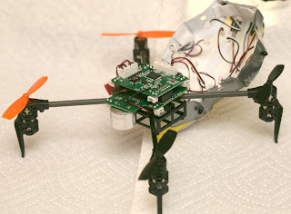
Infra X teardown


As expected for an undamped, strictly proportional feedback system, it bounces off walls faster & faster until it crashes.  It can't hover stationary, from the reflected IR.  Walls not completely reflective, not completely seemless, or not orthogonal to the sensors are less effective.

To engage the altitude hold, fly above 0.2m & get it to settle into a descent with fixed throttle.  It automatically fixes it at 0.2m.  It seems to work over carpet.

Any reflected sunlight pushes it away from a long distance.  The feedback makes it harder to fly manually, as the ever changing sensor angles & reflectivity of the walls constantly create random amounts of unbalancing.  It uses a 600mAh battery, a new record for a copter this small.  The increased weight destroys the propellers in crashes a lot faster than the old Ladybird.

The amount of site preparation to get the perfect reflections & lack of any damping show why IR hasn't taken the job of localization from optical flow.  It's easier to lay down a reflective floor than set up perfect walls. 

ir06.jpg

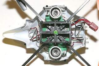
It does have longer landing gear than the Ladybird, probably to meet the clearance requirement for sonar to initialize.

ir07.jpg

ir08.jpg


 All the IR sensing, flight control, & radio is on 1 board, complete with MOSFETs, snubber diodes, extra space for the LED headers, an extra connector for the flashing LEDs.  It has a pot for adjusting the heading sensitivity, but it's too much work to unplug all 8 IR connectors to get to this board.

ir10.jpg


ir09.jpg


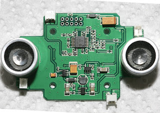
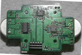
A TI CD4069 hex inverter drives 1 transducer.  A bag of  Microchip 6L04 op-amps amplify the other transducer.  The mane atmel controls everything.  This board has headers for the IR receivers, so some of the op-amps probably go to IR.

ir11.jpg


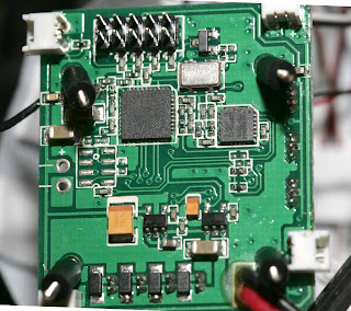
Standard Cypress radio & Invensense gyro, with rubber shock absorbers.  This board has headers for the IR emitters.  Whether or not it was intended, all the noisy motor power is on this board, while the IR & sonar amplifiers are on the other board.

ir12.jpg


Anyways, looking at how it was manufactured, each LED & photodiode painstakingly taped down by hand & connected with its own JST connector into a tiny nest of 16 wires, someone with a lot of power & labor at his disposal decided this was going to work.  He was convincing enough to shift a lot of money to making it.

Meanwhile, the Marcy class aircraft, which have worked better with less site preparation since Jan 2012, have never won any investment.  It's more about how it's sold, rather than how well it works.  Selling it as an experimental model to RC pilots wins them over, but selling it as a machine which can cook toast & fly it into your mouth is going to get you laughed out of China, no matter how much better at being an RC model it is than anything else.

Everyone wants a high volume consumer product, but UAV's are such a high profile product, even the dumbest suits can't be fooled when the current state of flying robot technology doesn't match the sales pitch.

Read more…

3689506886?profile=original

A Drone? A Really Big Bird? A UFO? What Did Alitalia Pilot See Near JFK?

FAA Looking Into Pilot's Claim Of Seeing Unmanned Or Remote-Piloted Aircraft

LINK: News Story

NEW YORK (CBSNewYork) — A mystery in the sky over New York City on Monday got one commercial airline pilot’s attention.

The Federal Aviation Administration is investigating a report from the pilot, who claims he saw an unmanned or remote-controlled aircraft while on his final approach to John F. Kennedy International Airport.

The pilot, who was at the controls of Alitalia Flight AZA 60, spotted what may have been a drone about four to five miles southeast of the airport at an altitude of 1,500 feet while on final approach to Runway 31 Right at about 1:15 p.m.

The Alitalia flight landed safely minutes later.

Please stay with CBSNewYork.com for more on this developing story

Read more…

3689507042?profile=original


Canon just annonced a new high sensivity camera with low noise. A new age for FPV night age is coming ?

Unfortunately I'm unable to embed video, so you have to click on the image to go to the Canon website.


The newly developed CMOS sensor features pixels measuring 19 microns square in size, which is more than 7.5-times the surface area of the pixels on the CMOS sensor incorporated in Canon's top-of-the-line EOS-1D X and other digital SLR cameras. In addition, the sensor's pixels and readout circuitry employ new technologies that reduce noise, which tends to increase as pixel size increases. Thanks to these technologies, the sensor facilitates the shooting of clearly visible video images even in dimly lit environments with as little as 0.03 lux of illumination, or approximately the brightness of a crescent moon—a level of brightness in which it is difficult for the naked eye to perceive objects. When recording video of astral bodies, while an electron-multiplying CCD,*2 which realizes approximately the same level of perception as the naked eye, can capture magnitude-6 stars, Canon's newly developed CMOS sensor is capable of recording faint stars with a magnitude of 8.5 and above.*3


You can watch video demonstration and more detail on Canon Website

Read more…

hybrid quad design

http://youtu.be/STD5d4goHc4

there is the first draft of a quad design i want to build this summer. It's a  project made with the coloboration  Maxime Carrier.

The objective is only to make a high performance wierd looking quadcopter XD.

2 low speed big fan for stationary fly and 2 rotary high speed smaller fan for stabilisation and high speed thrust.

Now de fun part is to design it for real. XD

leave your comment about this  design XD .

Xavier Simard-Lecours

Student in Mechanical Engineering

p.s. sorry for my bad grammar 

Read more…
Moderator

Indoor flight doing by Emile , Stefano , and Flavio during Model Expo Italy 

In the first video is possible to see Emile and Flavio that doing an indoor flight with VRBRAIN firm rev 2.9.2 Hexa Configuration.

The second flight is doing by Stefano with ultra light full carbon frame VR Special Drones.

 Original Blog Post : http://www.virtualrobotix.com/profiles/blogs/some-video-doing-during-model-expo-italy-indoor-flight-with-vrbra

Read more…

3689506947?profile=original

In a welcome contrast to the current posturing of the American media right now, the police in Bologna, Italy have affirmed that drones still have the same legal protections as any other personal property, even when trespassing.

A local aerial photography company was demonstrating their microdrone at the University of Bologna (presumably beyond line of sight without FPV) when it lost GPS signal and performed a failsafe landing on an unnamed student's terrace. The student then made the unfortunate decision to put the craft up for sale on an Italian auction website for €1000, a crime which could earn him a year in jail.

Property laws are similar throughout the western world, but I suspect that the owners of this supposedly $40000 drone got more help from the Italian postal police than I would get from my local police if I lost my cheap foamy. Despite that, I think I'll make a "keeping lost property is a crime" sticker for it, just in case one day the threat of jail time encourages someone to help reunite me with my plane.

Read more…
100KM

Techpod 6 cell 10,000 mah test flight

Went and flew at 60 acres today. only had time for a 20 minute test flight. the camera was out of focus and it was getting dark. This was flown with a foxtech 370 kv motor , two 5000 mah 6s lipos, APC 12x8, castle ICE 50 ESC, minum OSD and APM2.5 (data logging only for now)

produstion-sample-first-flight.jpg?w=900

This is from the logger on the ESC. and full log from ESC from the looks of it I am good for well over 3 hours flight time.

techpods in stock and shipping now. hobbyuav.com

Thanks

wayne

Read more…

Inexpensive platform for drone experimentation

I wanted to try an inexpensive platform for drone experimentation with APM 2.5, and I found that a plywood frame was suitable for my purposes.

3689506799?profile=original

Here is the part list:

Frame:

Hobbyking Quadcopter Frame 680mm - $9.95

Motors:

Turnigy Multistar 4822-490Kv 22Pole Multi-Rotor Outrunner - $30.99

Propellers:

Slow Fly Electric Prop 11X4.7SF (4 pc) - $3.64

Speed controllers:

Turnigy dlux 20A SBEC Brushless Speed Controller w/Data Logging (2s~4s) - $14.76

3689506840?profile=original

Total weight: about 1.5 Kg with 3000mAh 4S1P

I have a lot of free space on the frame and I can use it for video link devices and so on.


The quadcopter is pretty stable also in auto mode, and the motors-propellers system is quite efficient.

Battery life:


with 3000mAh 4S1P: 16 min
with 3000mAh 3S1P: 12 min
with 2200mAh 3S1P: 9 min

3689506920?profile=original

Please tell me your thoughts.

Read more…
Developer

Hi ya'll,

I'm developing a new drone sharing webapp:  www.droneshare.com.   Here's a screenshot, see below for more information...

3689506680?profile=original

So, while I was developing Andropilot I found myself frequently asking folks to send in tlog files for debugging.  Then later a discussion started about web based control and monitoring of Mavlink connected vehicles.  I decided to make a webapp to address both issues and hopefully enable easy sharing of flights here and on facebook etc...

If you'd like to alpha test something new, I'd really appreciate any feedback you have to offer.  We can discuss ideas by replying to this post or starting a thread in our new discussion group.

The current feature set is pretty limited, but I suspect features will be added quickly.  Current features:

  • Upload of multiple tlogs through a drag-and-drop UI
  • Google maps & earth view
  • Download of annotated kmz files
  • Auto extraction of APM 'param files' from tlogs
  • A basic plotting view
  • A parameters browser (with documentation)
  • Basic stats display

Features that should come soon (in the next couple of weeks):

  • Automatic optional uploads from Andropilot (if other GCS developers want to add droneshare support send me a note and I can provide the easy instructions)
  • Grouping flights by user handles
  • Browsing flights based on distance etc...
  • data channels for the plot view

Features that will come a little later:

  • Achievements/badges
  • Real time upload, display & control via 3G

Some more screenshots...

3689506777?profile=original

3689506852?profile=original

Read more…
3D Robotics

3689506806?profile=originalFrom Reuters:

They hover over Hollywood film sets and professional sports events. They track wildfires in Colorado, survey Kansas farm crops and vineyards in California. They inspect miles of industrial pipeline and monitor wildlife, river temperatures and volcanic activity.

They also locate marijuana fields, reconstruct crime scenes and spot illegal immigrants breaching U.S. borders.

Tens of thousands of domestic drones are zipping through U.S. skies, often flouting tight federal restrictions on drone use that require even the police and the military to get special permits.

Armed with streaming video, swivel cameras and infrared sensors, a new breed of high-tech domestic drones is beginning to change the way Americans see the world - and each other.

Powered by the latest microtechnology and driven by billions in defense industry and commercial research dollars, domestic drones are poised for widespread expansion into U.S. airspace once regulation catches up with reality.

That is scheduled to begin in late 2015, when the U.S. government starts issuing commercial drone permits.

Veteran aerial photographer Mark Bateson, a consultant to the film and television industry and some police departments, said one reality show producer asked him last year whether his custom-made drone could hover over a desert and use its thermal imaging sensors to spot ghosts for a ghost-hunter reality series.

Bateson rejected that request. "But I heard they eventually found someone to do it," he said.

"Commercially, the culture already exists," said Ben Miller, a Mesa County, Colorado, sheriff's deputy who has been flying drones with special authorization from the Federal Aviation Administration since 2009.

"Turn on your TV and pay close attention to major sports events. You'll see that in many cases they are getting aerial shots using a UAS (unmanned aerial system). I would venture to say that if you've seen an action movie in the last five years, chances are that a UAS was used."

OPEN SKIES

Federal legislation enacted last year requires the FAA to prepare a plan to open U.S. skies in 2015 to widespread use of unmanned aircraft by public agencies and private industry.

Potential markets include agriculture, shipping, oil exploration, commercial fishing, major league sports, film and television production, environmental monitoring, meteorological studies, law enforcement and the news media.

The aviation and aerospace industry research firm Teal Group estimated last year that global spending on unmanned aircraft will double over the next 10 years, to nearly $90 billion, with the U.S. accounting for 62 percent of research and development spending and 55 percent of procurement spending.

For decades, model airplane hobbyists have been allowed to fly small, remote-controlled aircraft up to 400 feet and at least a quarter mile from any airport. While public agencies can get permission to use unarmed drones, all commercial use remains banned.

"As a hobbyist - I can do whatever I want right now, within remote-control guidelines," said Bateson, the aerial photographer. "But as soon as you turn it into a business ... the FAA says you are violating the national airspace."

Bateson said that whether his drone shoots video for fun or for profit, "there is no greater danger to the national airspace."

Last year the National Football League petitioned the FAA to speed the licensing of commercial drones, joining Hollywood's Motion Picture Association of America, which has been lobbying the agency for several years, an MPAA spokesman told the drone news website UAS Vision.

The FAA has issued 1,428 drone permits to universities, law enforcement and other public agencies since 2007, when the agency formally banned commercial drone use. Of those, 327 permits remain active, said FAA spokesman Les Dorr.

TOUGH TO ENFORCE

Bateson flies a customized 48-inch-wide Styrofoam fixed-wing remote-controlled aircraft that cost about $20,000 - compared with up to $1 million for a helicopter. He said his aircraft has logged 1,800 miles and has recorded 60 hours of high-resolution video. He said he has never run into trouble with the FAA.

Patrick Egan, an unmanned aircraft consultant to the U.S. military and editor of sUAS News, a drone news website, said the FAA's commercial ban on drones is unenforceable.

"How do you possibly enforce these regulations?" he said.

Earlier this year, Connecticut marketing firm ImageMark Strategy and Design launched a drone-powered aerial photo and video service to offer to its existing clients, which include universities, golf resorts and real estate firms.

Partner Scott Benton said his company invested about $20,000 in remote-controlled multi-rotor copters equipped to carry camcorders or SLR digital cameras with swivel tilts. Benton said he wasn't even aware of FAA restrictions on commercial drone use until after he purchased all the equipment.

He said his company plans to charge clients for editing and post-production work, not the drone flights.

Many commercial drone operators offer similar arguments. Some say they operate only on private land. Others say they are selling data, not drone flight time.

Still others say they will simply take their chances.

"Honestly?" said one commercial operator, who requested anonymity to protect his business. "My hope is that I'm far afield enough and small enough potatoes to the FAA that I can fly under the radar on this one."

PRIVACY CONCERNS

In 2011, News Corp's tablet news site, the Daily, sent a Microdrone MD4-1000 into the skies over Alabama, Missouri and North Dakota to capture dramatic aerial footage of flood damage. A subsequent FAA investigation resulted in a warning, an FAA spokesman told Reuters. A News Corp spokesman declined to comment.

Last fall, a collective shudder rose up from Hollywood when false reports surfaced that the aggressive tabloid news website TMZ was seeking permission to fly its own drone.

The report was false, but it raised concerns.

"I'm less worried about the police getting a fleet of drones than I am about the news media," said Egan.

"Imagine what it will be like when the paparazzi can send a fleet of drones into the Hollywood hills."

The boom in drone use, both private and public, is also raising privacy concerns.

Civil liberties groups are urging federal and state legislators to place immediate restrictions on drone use by U.S. law enforcement agencies, which have historically been quick to capitalize on emerging technology like cell phone tracking.

At least 15 states have drafted legislation that would restrict drone use. In Seattle last month, a public outcry prompted the mayor to order the police chief to return the department's two new drones to their manufacturer.

BLACKSHEEP DRONES

An even bigger concern for many is security. The activities of some drone operators are fueling fears about the potential for terrorism or that drones could interfere with manned air traffic and cause an accident.

A group of skilled drone operators using "first person view," or FPV, technology, has sent Ritewing Zephyr drones that capture high-quality video of visual thrill rides around some of the world's most famous landmarks.

The group, known as Team Blacksheep, has made a series of videos using drones circling the torch on New York City's Statue of Liberty and London's Big Ben clock tower. Team Blacksheep's FPV drones have darted through the arches of the Golden Gate Bridge and buzzed the peak of the Matterhorn.

The videos, captured at dizzying angles, are wildly popular online, but hobbyists and other drone enthusiasts worry that such videos give the industry a bad name.

"Those are the people the FAA should be going after," Bateson said.

A Team Blacksheep founder did not respond to requests for comment on security concerns.

Would-be attackers have already tried to exploit drones. Last fall, a Massachusetts man was sentenced to 17 years in prison for plotting to attack Washington, D.C., with three remote-controlled airplanes carrying C-4 explosives.

Drones may also be vulnerable to hacking.

Last summer, Department of Homeland Security officials challenged Texas aerospace engineering professor Todd Humphreys and his class to try to "spoof" a DHS drone's GPS system.

GPS "spoofing" is a technique by which a vehicle's GPS receiver can be tricked and taken over by a slightly more powerful signal that mimics the attributes of the original signal - essentially an airborne hack.

Humphreys and his students succeeded in hacking the drone and took control of its flight path.

If a college class "can spoof the GPS, what can other nation states or terrorist groups do?" Representative Paul Broun (R-Ga.) asked at a recent congressional hearing on domestic drones.

CHINESE DOGS

Some U.S. drone designers worry about the consequences of what they see as a slow U.S. response to a rapidly evolving technology.

"The Chinese are going to kill us," said Texas pilot Gene Robinson, who spent $20,000 designing an innovative fixed-wing drone for search-and-rescue missions. "They have copied every single design, including mine, that they can get their hands on."

Robinson said he installed Web-tracking software on his drone design Web page and then watched last spring as a Chinese design company "spent a month on my Web page ... reverse-engineered my design" and began selling mass-produced copies in December - for $169.

Side-by-side pictures of Robinson's model and the Chinese model that he showed a reporter look virtually identical.

Robinson went online and ordered one of Chinese models - to see if he could attach his equipment to the cheaper version.

"It was a dog, a pig," he said. "It didn't fly worth a damn."

(Reporting By Chris Francescani; Editing by Claudia Parsons and Douglas Royalty)
Read more…
T3

Arduplane goes to ASPRS annual Conference

For those who dont know ASPRS, is The American Society for Photogrammetry and Remote Sensing. 

On their 2013 Annual conference call for abstracts, gladly they included Unmanned Aerial Vehicles!!


And here we go! After almost  3 years of developing, breaking, breaking... and more breaking.. we managed to succesfully build a rig to fullfil our needs and also, translate hundreds of Precision Agriculture formulas and models to GIS-Automated rutines!


This extraordinary alchemy of UAS construction, GIS, Agriculture and Aerial Mapping, will be presented as a paper at 3:30 pm to 5:00 pm, Wednesday, March 27th  in the Unmanned Aerial Vehicles session. The Conference will take place at Baltimore, Maryland USA -  Baltimore Marriott Waterfront Hotel.


Creation of a Remote Sensing Unmanned Aerial System
(UAS) for Precision Agriculture and Related Mapping
Applications
Dimitrios Stefanakis(Me), University of the Aegean, Greece
John Hatzopoulos, Margaris Nikolaos, and Danalatos Nikolaos


Abstract:

Our goal is to create a fully autonomous airborne remote sensing platform, for the production of various vegetation indices to determine growth, development, yield crop and provide considerable information in real time and at low cost (compared with existing methods) for the study area.

The primary tool for extraction and production of the information is an unmanned aerial system (UAS) that carries sensors and cameras flying over the study area, transmitting real time data that has been programmed to collect. The collected data is land cover, geographic location, weather data, geomorphologic and cadastral data, ortho-corrected derivatives and qualitative data type coverage, biomass and other parameters that have been introduced to the platform via computational GIS routines.

This idea emerged during the analysis of the functional ecology in Greek agro-ecosystems within spatial information and mapping. To take full advantage of dynamic tools of IT, such as Geographic Information Systems and Expert Systems, Global Positioning Systems, Remote Sensing and Agriculture Engineering tools.

The platform named "Skiptrovamon" has numerous applications and is used as a tool in many scientific fields, such as; precision agriculture, geography, geomorphology, topography, urban geography, and remote sensing.

Skiptrovamon was designed and has been tested as remote sensing platform for precision agriculture. As the aircraft flies over the study area it collects information from cropland and outputs, yield crop, current biomass, indicate the stressed plants and possible lack or adequate irrigation and fertilization in real time through computational routines.

Key words: UAS, UAV, Skiptrovamon, agriculture, remote sensing, GIS


We would never be able to do anything, if APM, and this communtity didnt provide us the tools!! 

Once again, i need your backup!  if you are arround i definetly need a supportive audience and also meet some of you in person (Living in Greece doesnt make meetings easy :) ). 


ACKNOWLEDGMENTS

We would like to thank, UcanDrone Team: Nikos G Gerarchakis, Major of Hellenic Army Corps of Engineers, Apostolos Gadetsakis, Senior Officer Telecommunications Engineer of the Hellenic Air Force and Stefanos Nasos, Sail plane pilot, Test pilot of the Team, for providing us the tools to construct and test the prototype aircrafts of this study.

We owe a great thanks to DIYDrones.com community and APM developers team, for providing certain solutions to our needs, free software and helping us thru the integration process.


More info, for the Construction, Paper etc, will follow after the presentation!

Read more…