All Posts (11086)

Sort by

3689726239?profile=original

At the just-concluded GUSC Unmanned Systems Conference & Expo, ZIYAN released the "PARUS ", the smallest high-performance intelligent electric unmanned helicopter in the country, arousing great concern in the industry. PARUS will surely bring about a revolutionary application in the industry with its most cutting-edge design and breakthrough performance. And it is really cost-effective.

3689726322?profile=original

3689726275?profile=original

At present, Parus, with prices starting at US$ 15000,  compared with the same type of products on the market, more cost-effective.

Only 2KG lightweight design
PARUS ,only 2KG, its carbon fiber body design not only high-strength and light-weight but also has non-oxidizing environment resistant to high temperature, fatigue resistance, corrosion resistance and many other advantages. So that PARUS can handle more harsh environment of the mission.

3689726376?profile=original

50min excellent flight endurance

Thanks to the special performance model of helicopter structure and the high-performance power system independently developed by ZIYAN, PARUS has a more than 50 minutes flight endurance under the guaranteed battery margin of safety, which has obvious advantages in long-time flight missions.

3689726339?profile=original

50km of flight distance

PARUS can reach a cruising speed of 60km / h and a maximum speed of 100km / h, achieving an average cruising range of 50km under the safety margin. It can easily accomplish large-scale and long-range flight tasks such as power patrolling and photovoltaic check-off.

3689726350?profile=original

10km HD video transmission

PARUS ,equip with ZIYAN high-definition video transmission system. The design of this system is based on software and radio SDR development , the bottom of communication 4G network LTE physical layer, combined with OFDM and Turbo coding and other advanced communication algorithms, has strong anti-multipath effect and Error correction capability. Figure transmission of digital communications up to 10Mbps, the effective transmission distance up to 10km.

3689726286?profile=original

10x HD PTZ camera

PARUS equip with three-axis zoom PTZ, and 10x optical zoom lens, applicable to the inspection of various industries, The infrared thermography camera can also be selected for the work at night or other circumstances

Intelligent tablet operation

The ground station APP uses a simple and convenient interactive design to provide a variety of intelligent route planning for user selection.The PARUS can cooperate with the ground station to carry out BLOS flight, area scanning, one button return, even intelligent operation of moving base landing . Coupled with the external handle, the user can control the flight and attitude of the aircraft in real time, easy to operate the entire operation, truly simplified operation.

 3689726405?profile=original

Come to me to learn more : yana@ziyanuav.com
Read more…
3D Robotics

3689724883?profile=original

We are happy to announce the release of PX4 v1.7.0, this version comes packed with performance and quality of life improvements. With 1840 commits with the help of 76 authors and hundreds of flight hours across all of our certified hardware, this is the biggest release of PX4 to date.

This release couldn’t have happened without the help of our supporting members, developers, and partners that help us every day, from planning to execution, we are grateful for this community and hope you enjoy flying PX4 v1.7.0.

MAJOR FEATURES

  • First-generation experimental support for ROS2-like setups with FastRTPS
  • Support for many new sensors (LIDAR, airspeed, IMU, etc)
  • Significant robustness improvements and new features to default estimation system (EKF2)
  • Significant improvements to VTOL flight control
  • Increased smoothness of multi-copter flight control
  • Better performance of fixed-wing flight control
  • Many build system improvements (including 50% faster Nuttx builds)
  • New continuous integration system (http://ci.px4.io) with significantly more build and testing capacity
  • Reduced CPU load and RAM usage
  • Plus more tons of minor bug fixes and under the hood enhancements
  • Full list of changes

DOWNLOAD

You can flash the v1.7.0 release from QGroundControl or grab the binaries for your platform directly from the v1.7.0 release tag

FEEDBACK

If you have any feedback you would like to share here are some options:

Read more…

Drones for Firefighting: Infographic

3689726192?profile=original

In the past, local authorities have complained about the irresponsible use of UAVs and issued a plea to drone hobbyists to keep their drones grounded as they can cause major delays and problems in firefighting operations. However, the responsible use of this technology can play a large part in fire departments as drones can be a powerful tool to reduce hazards to life and property. 

According to Dronefly’s infographic, between 2009 and early 2017, around 347 public safety departments in the U.S. bought drones, and 69 of them were fire departments.

Here are four key uses of drones in the fire service:
Firefighting Drones
Infographic Provided by Dronefly.com

Read more…
3689724861?profile=original
Here again an update of DroneClash.
Eight teams signed up at the last moment of the deadline! Exactly what we were aiming at.
The ticket sale (www.droneclash.nl/tickets/) is now officially opened, for 15E you get access to a day long of drones: from DroneClash battles, to a counter-drone and security expo, and even live outside demos.
for more info visit: www.droneclash.org
The DroneClash team
Read more…

HYBRiX, 3 hours and 35 minutes flight time in hover

Hi all,

I would like to share our last experience. It is a flight of 3 hours and 35 minutes in hover. It is our longest flight so far, the flight is an internal test in which we did not plan to fly so long. In fact we had 400gr of extra weight that could have been removed and the fuel tank was not full at all. We take off with 5 liters but it is possible to fill 5.2 liters or so.

The relevant thing for us is that this unit is a "stock" aircraft, we have not made any modifications, lightening or additional fuel tanks to do this test, the maximum flight time of the aircraft should be about 4 hours, obviously without any payload. I think that in normal operation flight times should be between 2 and 3 hours.

Regards, jlcortex
Read more…

Getting Started with Emlid Reach RS

Hey there!

We’ve recently released the first video of Emlid Reach RS RTK GNSS Receiver Getting Started series!

The video covers the process of first-time updating: powering Reach RS on, connecting to a Wi-Fi and installing the latest version of ReachView. 

It will be especially helpful for beginners starting using RTK GNSS receivers by Emlid for land surveying, mapping, precision agriculture and other applications requiring centimeter accuracy!

Check the updated quickstart guide for Reach RS in our docs: https://docs.emlid.com/reachrs/quickstart

More tutorial videos are coming soon!

Read more…
3D Robotics

3689724845?profile=original

From a FAA alert about a bug in the Rockwell Collins autopilot that is used in many jetliners. Interesting, it's easier for them to fix the airport database that these autopilots use than the autopilot code itself, although that will be coming later. 

"If the crew manually edits or temperature compensates a “Climb to” altitude, the FMS will remove the database turn direction (if any) on the immediately following leg. The FMS will turn in the wrong direction after sequencing the “Climb to” leg if the shortest turn direction is different than the required turn direction onto the next leg."

...

"Rockwell Collins has removed from both the Jeppesen and Lufthansa (LSY) Navigation Databases the approaches for which the FMS may not turn correctly after an altitude is edited beginning cycle 1712. This resulted in the removal of approximately 10,000 approaches. Rockwell Collins is working on corrective actions for this issue to restore the removed procedures and has been providing regular updates through email communication."

Read more…

MAP-Tech USV Autopilot

Thought i would post a video of my MAP-Tech USV conversion done on a center console boat, All kinds of data feedback & control over I.P with less than a second delay. 

3689724962?profile=original

I Used the MAP-Pro Autopilot + the C2-Pro GCS -  both MAP-tech products to get this project done. www.map-tech.com

Read more…

Hi everyone, I posted a new video of my series. This time we are going to write a script for tracking a circular trajectory around a waypoint that we provide using Mission Planner.

Be sure you watch the previous video about Drone Delivery as we are going to use a lot of code developed before.

Find the code on my Github

Find the whole Youtube Playlist

Read more…

2 years ago we decided to make a professional mapping &surveying drone and not just for surveyors also with easy API's to help developers/researchers to develop drone applications quickly. And we took 4 main priorities on DroneePLANE:

1.Super easy to operate

2.Safe

3.Easy to carry 

4.Affordable

With these main priorities after 2 years DroneePLANE was born. The Professional Mapping and Surveying Drone.

3689724776?profile=original


TECHNICAL SPECIFICATIONS

Weight -----------------------------------------. 0.6 kg 
Payload capacity------------------------------0.18kg
Wingspan --------------------------------------100cm 
  Material ---------------EPP foam,carbon structure 
  Propulsion -----------------Electric brushless motor
 Battery -----------------------------10.8 V, 3500 mAh
 Carry case dimensions ----------65 x 50 x 30 cm 

SOFTWARE 

Flight planning & control software --------- DroneeCockpit

(Ground Control App currently works on Ipad)

FLIGHT CHARACTERISTICS

Maximum flight time---------------------------up to 60min

Optimal Cruise speed-------------------------------12 m/s

Radio link range----------------------------------Up to 5km

Wind resistance--------------------------------up to 12m/s

CAMERA

Dronee supports Sony/GoPro with wifi and all gphoto2 triggering supported cameras including Parrot Seqoioa.

Dronee COCKPIT

Ground Control Software

We designed DroneeCockpit from ground up to empower non-pilots to simulate challenging realistic flight missions through its sophisticated design, and no prior flying experience is required!  You can download  Dronee COCKPIT from App Store and try by yourself.

3689724251?profile=original

DroneeCockpit has many advanced features like:

Multi Flight feature: you can scan even larger area with multiple flights.If the battery finishes during the scan.Dronee lands and memorizes where it left in the next flight.


Optimized Flight Plath: For windy weather DroneeCockpit Flight Management Software has “Route Optimisation”  algorithm, it  rearranges waypoint orders to give less drift in windy conditions without changing the result of the process.

3689724265?profile=original

DRONEE  API for Developers

Last but not least, DroneePlane is developer friendly. It has built-in companion computer  (RaspberryPi CM3)  with running  Linux operating system and also it has on board GPIO. DroneePlane comes with easy API's to help developers/researchers to develop drone applications airbornready quickly.

For more information check our website : https://dron.ee/pages/droneeplane

You can also contact us for special customization.

Cheers

Read more…
3D Robotics

3689724668?profile=original

Impressive work by the University of Warwick, who are designing a Pixhawk-powered drone from search and rescue. Above, a test device for Pixhawk. Below, a mold for the carbon-fiber mold. 

3689724596?profile=original

From the article:

The design now has a 2.2-meter (7.2-foot) wingspan, multiple imaging cameras, and an antenna tracking system at the base station to maintain contact. It also features two control systems designed in Autodesk EAGLE: a traditional manual transmitter for takeoff and landing and an autopilot system controlled by modified open-source software.

Warwick Associate Professor of Engineering Simon Leigh, who specializes in additive manufacturing, guided Barlow’s team during the project. He knew they would 3D-print reusable molds of the UAV body parts and then use them to resin-infuse strong-yet-light carbon fiber to create the finished product. Leigh says it took about one month of continuous 3D printing to finish the molds. After that, infusing the carbon fiber proved a challenge, as well.

“We used liquid-resin infusion, which is under the vacuum,” Barlow says. “You apply a vacuum to your carbon fiber on the mold, and then you inject resin into it under the vacuum. That’s generally done on a much bigger scale, with much easier geometric parts than we were using, so we had to invent a lot of really cool tools to do it.”

Barlow couldn’t elaborate on those inventions due to the terms with industry partner GKN Aerospace, which may commercialize some of them down the line. To exercise that kind of innovative thinking while working with an expert company was a great experience and opportunity for the students, Leigh says. And they continue to employ creative thinking toward making parts of the UAV multifunctional to maximize its weight

For example, the UAV’s main function will be to search for casualties on a mountain, land next to them by parachute, and deliver supplies. But the parachutes could be made of emergency space blankets for the people to use, and other equipment could also be built into the aircraft. Customized software could even tailor the payload for the needs of each emergency.

“It would suggest the load out you would need and how to balance it to get the right center of gravity,” Leigh says. “So we cataloged the supplies we want to put in it and worked out where they might sit in the airframe.” The group has also explored using Autodesk Netfabb additive-manufacturing software to optimize aspects of the UAV design to be 3D-print friendly and reduce weight.

Barlow’s goal for the UAV was a carrying capacity of about 5 kilograms (11 pounds) and an 80-kilometer (49.7-mile) range, but that’s much farther than current UK regulations allow for this type of drone. The many layers of regulation applied to UAVs from the UK’s Civil Aviation Authority (CAA) and the wireless communications regulations from Ofcom are “bit of a minefield to navigate,” Leigh says.

Read more…

Compact Rugged Ground Control Station

3689724681?profile=original

It's been a while since I posted write-ups or photos of any of our latest series or batch production models here, but this system has been available since March this year, so I'm not putting this out any further.

3689724717?profile=original

As many of our previous all-in-one units, it is built into our favourite Peli 1400 enclosure, so IP67 during transport is already a given. While all controls, seals and the entire manufacturing technology is at least at IP67 levels, we only rate the stations up to IP54. The main reason is because we don't want people to use high pressure water jets to wash these with some sandblasting effects on screen sunlight readability... :-)

3689724742?profile=original

This very unit was our prototype back then, so it still carried a couple of experimental and testing features. It has separate power controls for all internal and external modules, (Gb Ethernet, USB, RF box, keyboard, RC TX, etc.), which are replaced with group switching for the different application scenarios in the production version.

3689724624?profile=original

The built-in battery is a PCM managed and balanced 10Ah 4S LiFePO4 block, which gives more than eight hours of autonomy under all circumstances, even if all the RF modules and the antenna tracker are powered directly from the station.

Mainly as a support for legacy analogue-digital hybrid systems, which are using 2-3 separate RF bands RC/telemetry/video it also has a dedicated built-in SDR for field spectrum analyser purposes in the 10MHz-6GHz range. The optional SDR have found its final location in the external RF box, while there are still reasons for keeping such a sensitive unit away from the high-power RF modules.

However, as the latest digital transparent IP RF link modules are also based on SDRs, and thus can function as SAs in their particular band, there's no general need for adding a separate SA hw in there. Still, as the RF link is the most crucial element of nearly every UAV system, it's always nice to have a separate tool in the box to see what's going on around you.

3689724753?profile=original

The mechanical build follows our usual upside-down case format, which not only makes enough space for the joysticks and the controls, but it also creates a natural sunshade or hood around the 12" high res and high nit screen. The mandatory energy chain between the body and the lid runs into a sealed tunnel and an internal cable cavity, so it doesn't compromise the overall ingress protection level here.

Because the embedded IT hardware can range from Pentium Core M to i5-i7, proper thermal management is critical. Since we cannot just ventilate the enclosure directly while keeping it waterproof, we opted for a sealed robust thermal interface. It is based on an internal and an external heat sink directly connected to each other through the wall of the enclosure under the handle. While we also made provisions in the original design for an optional Peltier element there, the large surface of the direct metal contact was enough to keep things cool inside.

3689724806?profile=original

Both as a support for direct joystick control through telemetry and for training simulator purposes we've also included a PPM2USB interface, which can be switched both as an alternative and a simultaneous signal route from the RC TX logic. This gives you all the flexibility you need for different control options including an emergency redundant manual override.

3689724637?profile=original

Read more…

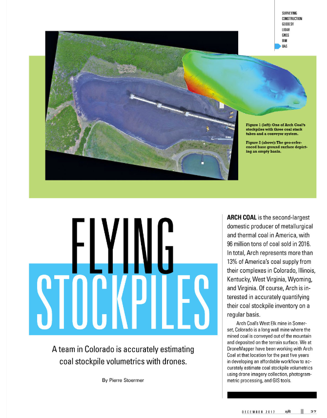
xyht-dec2.PNG

DroneMapper: DroneMapper.com

xyHt Magazine: http://xyht.com

DroneMapper has been working with Arch Coal over the past 5 years in the development of an affordable work flow to accurately estimate coal stock pile volumetrics at the West Elk mine utilizing drone imagery collection, photogrammetric processing and GIS tools. The resulting work flow could lead to a significant cost saving by establishing accurate volumetrics with low latency compared with traditional manned aircraft operations. Further, more frequent drone acquired volume estimates can be used to check calibration of the real-time conveyor weight scale measurements to assure consistent calibration of mechanical systems.

Arch Coal – is the second largest domestic producer of metallurgical and thermal coal, with 96 million tons of coal sold in 2016. Arch is a well-positioned American coal company with large, modern, low-cost mining complexes and high-quality reserves in strategic U.S. coal supply basins. In total, Arch represents over 13% of America’s coal supply from their complexes in Colorado, Illinois, Kentucky, West Virginia, Wyoming and Virginia.

DroneMapper – provides photogrammetric cloud processing, desk-top software and GIS services for clients around the world. The team offers end-to-end drone operation services for imagery collections and processing as well as training. Typical products produced include high accuracy geo-referenced DEMs, DTMs, orthomosaics, point clouds, precision agricultural NDVIs, terrain contours and volumetric estimates, among others.

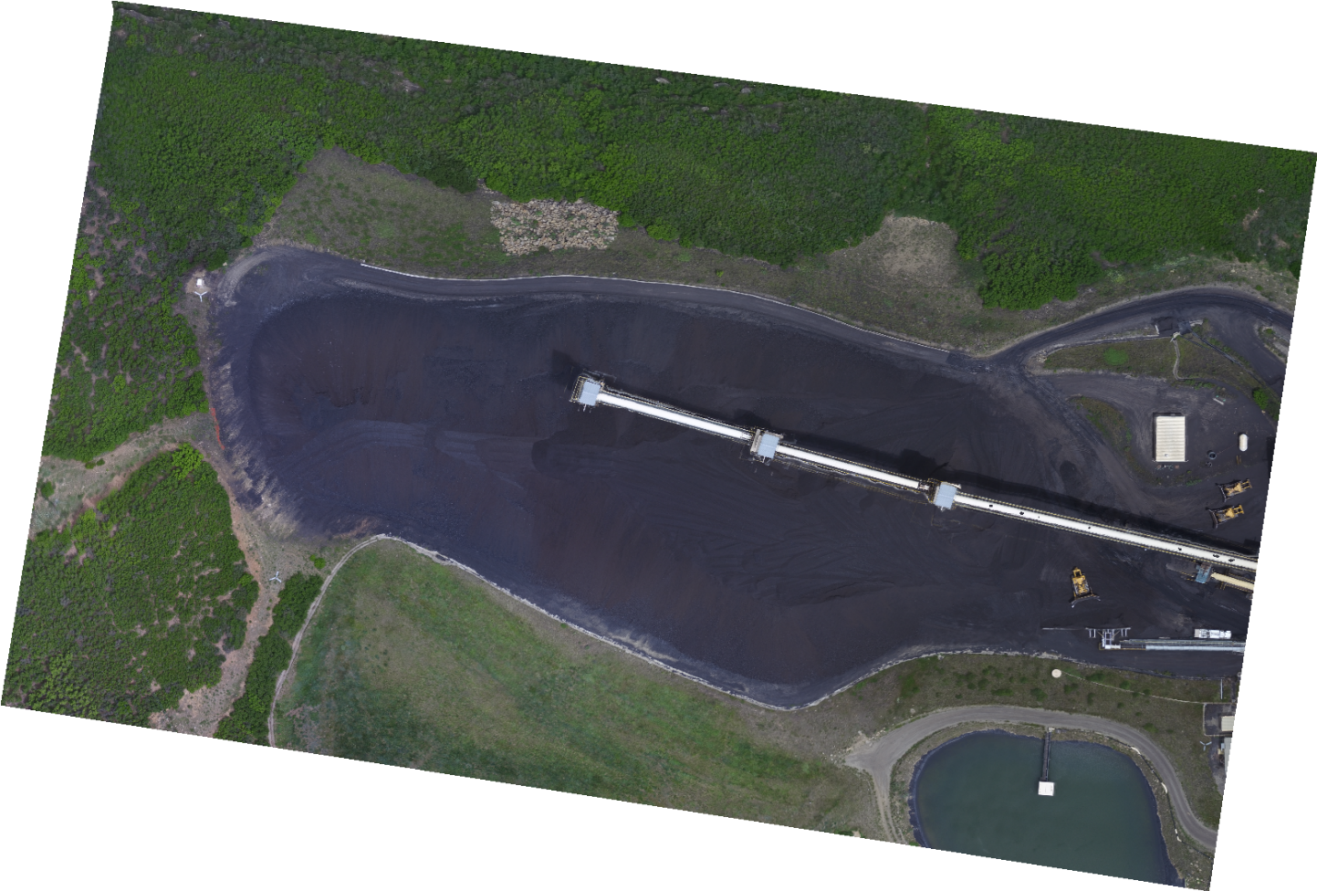
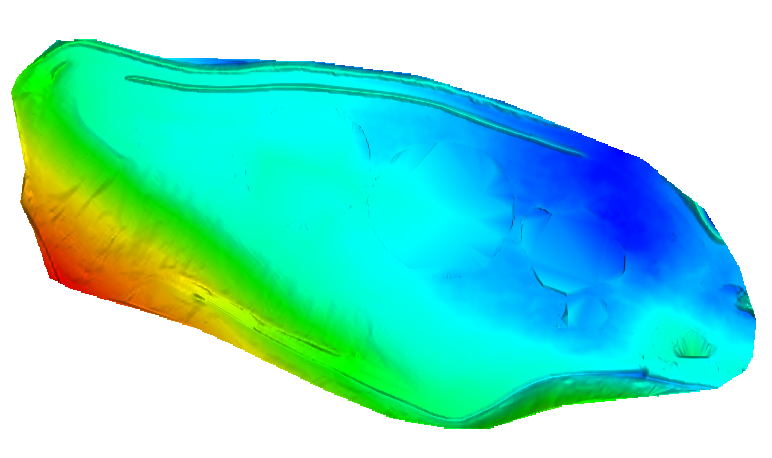
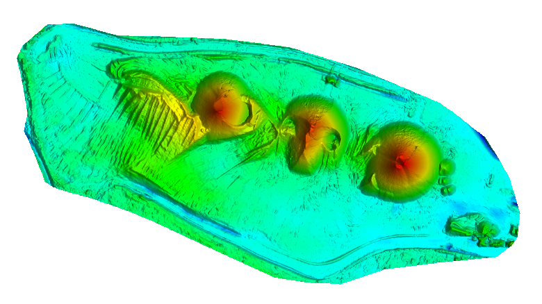
Arch Coal is interested in accurately quantifying their coal stockpile inventory on a regular basis. One example of this is the West Elk mine in Somerset, Colorado. The facility is a long wall mine where the mined coal is conveyed out of the mountain and deposited on the terrain surface. Figure 1 illustrates one of the stockpiles with three coal stack tubes (central left of image) with conveyor system. Ground control targets are used for every imagery collection to precisely align the imaged stockpile surface with the bare ground reference surface. Figure 2 shows the geo-referenced bare ground surface depicting zero volume or empty basin. This surface was precisely constructed using the control points that surround it. The colors represent the surface elevations with red the highest elevation and blue the lowest. Note the two ridges at the bottom of the surface illustration correspond to the ridge features seen in the stockpile image.

we-dec1.png

Figure 1: West Elk Stockpile

we-dec2.png

Figure 2: Geo-referenced Base Ground Surface

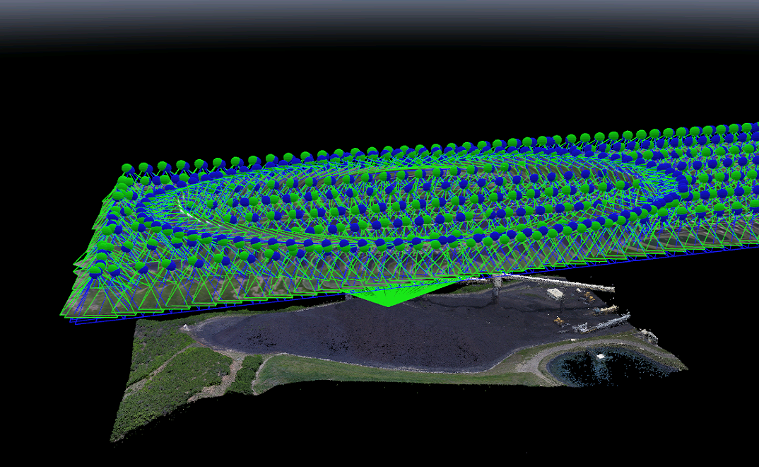
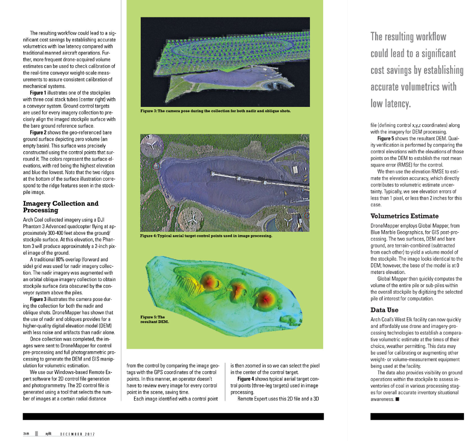
Imagery was collected by Arch Coal using a DJI Phantom 3 Advanced quad copter flying at approximately 300-400 feet above the ground/stockpile surface. At this elevation, the Phantom 3 will produce approximately a 2-inch pixel on the ground. A traditional 80% overlap (forward and side) grid was used for nadir imagery collection. The nadir imagery was augmented with an orbital oblique imagery collection to obtain stockpile surface data obscured by the conveyor system above the piles. Figure 3 illustrates the camera pose during the collection for both the nadir and oblique shots. DroneMapper has shown that the use of nadir and obliques provide for a higher quality digital elevation model (DEM) with less noise and artifacts than nadir alone. Once collection was completed the images were sent to DroneMapper for control pre-processing, full photogrammetric processing to generate the DEM and GIS manipulation for volumetric estimation.

we-dec3.png

Figure 3: Nadir and Oblique Collection Utilization

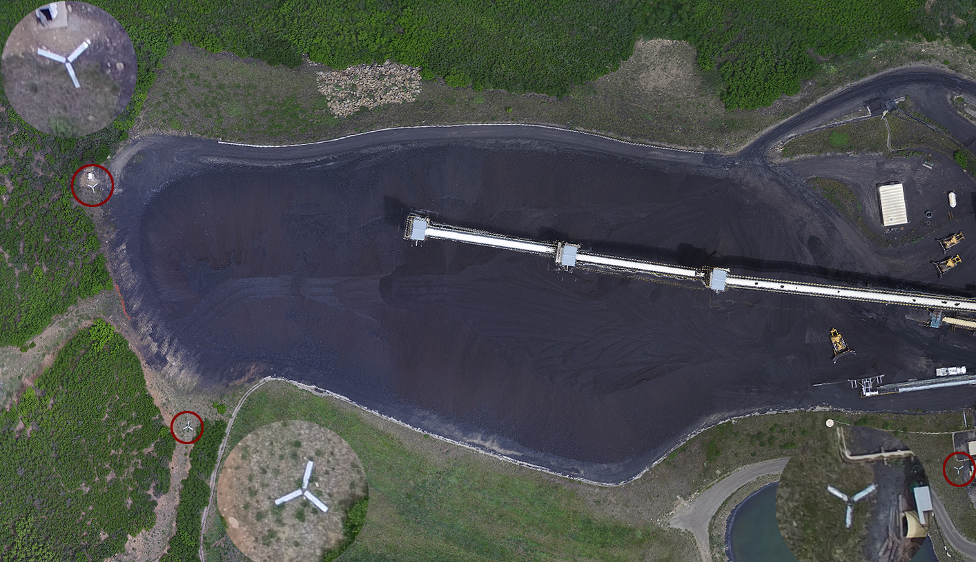
DroneMapper utilizes its Windows based REMOTE EXPERT software for 2-D control file generation and photogrammetry. The 2-D control file is generated using a tool that selects the number of images at a certain radial distance from the control by comparing the image geo-tags with the GPS coordinates of the control points. In this manner, an operator does not have to review every image for every control point in the scene, saving time. Each image identified with a control point is then zoomed in to select the pixel that the center of the control target appears. Figure 4 shows typical aerial target control points, 3-leg targets, used in image processing.

we-dec4.png

Figure 4: Mine Ground Control Points and Aerial Targets

REMOTE EXPERT uses this 2-D file and a 3-D file (defining control X,Y,Z coordinates) along with the imagery for DEM processing. Figure 5 shows the resultant DEM. Quality verification is performed by comparing the control elevations with the elevations of those points on the DEM to establish the root mean square error (RMSE) for the control. The elevation RMSE is then used to estimate the elevation accuracy which directly contributes to volumetric estimate uncertainty. Typically, we see elevation errors of less than 1 pixel or < 2 inches for this case.

we-dec5.png

Figure 5: West Elk DEM

DroneMapper employs Global Mapper, from Blue Marble Geographics, for all GIS processing. The two surfaces, DEM and bare ground are terrain combined or subtracted from each other to yield a volume model of the stockpile. The image looks identical to the DEM above, however the base of the model is at 0 meters elevation. Global Mapper then quickly computes the volume of the entire pile or sub-piles within the overall stockpile by digitizing the selected pile of interest for computation.

Data Utilization:

Arch’s West Elk facility can now quickly and affordably utilize drone and imagery processing technologies to establish a comparative volumetric estimate at the times of their choice, weather permitting. This data may be used for calibrating or augmenting other weight or volume measurement equipment being used at the facility. The data also provides visibility on ground operations within the stockpile to assess inventories of coal in various processing stages for overall accurate inventory situational awareness.

xyht-nov1.PNG

xyht-dec1.PNG

xyht-dec2.PNG

xyht-dec3.PNG

Thank you, The DroneMapper Team
 
 
Read more…

Skywalker Smart Twin-motor FPV Aircraft

3689724516?profile=original

    Skywalker Smart is first racing aircraft from Skywalker that has twin motor with strong energy.
    In order to satisfy hobbists's need, we launch KIT version on sales. It is well-built racer that has flexible wings, reasonable installation of inner space. It flies flexible and faster.

    You could see decay above the picture, it combines some elements on the banner. Also, there are mark of "caution" on the position of motor. We hope that hobbists could see this point and keep away from crowd.

3689724426?profile=original

3689724467?profile=original

You could see picture of aircraft from different angle, we use the fiberglass sheet winglet, which it could disassemble(not like plywood winglet as the product manual).

3689724496?profile=original


The dimension of Skywalker Smart is above the picture. And you could the specifications as below.


Specifications
Brand:Skywalker
Model:Smart
Material:Imported EPO
Wingspan:996mm
Fuselage:430mm

Wings area:25.9dm2
Flying weight:750-1000g
C.G:From nose behind 240-250mm
Take off:Hand cast
Landing:Glide down

Recommended Configuration
Motor:2206KV1850-2050*2PCS
ESC:30A*2PCS
Servo:12G*2pcs
Props:5045E/EP*2PCS
Battery:4S 1500-2200mah
Radio:3CH 2Servo

Product details

3689724533?profile=original


3689724570?profile=original


3689724550?profile=original


    If you have any question, you could contact with me at skywalker-ellen@outlook.com. Also, my skype is skywalker-ellen@outlook.com.

Read more…

Here is a great wood quadcopter project made with Pixhawk. The top speed is over 60mph and flies for 15 - 25 minutes depending on 4s or 6s batteries. It is able to lift 15lbs with reliability and tolerates crashes very well. Enjoy the test footage.

Future tests are planned but the operating budget is very low at the moment. New designs are under development

Read more…