All Posts (11086)

Sort by
3D Robotics

Great YouTube channel on using Dronekit, APM

Tiziano Fiorenzani, an Italian engineer now working in the US, has one of the best YouTube channels on using open source drone software, especially, APM, Dronekit and Python. Above is just one example, on Drone Delivery with Python:

We are going to write a script that connects with the vehicle and waits for the operator to upload a valid mission. Then the script adds our current location as final waypoint and the vahicle is commanded to arm and takeoff. The vehicle is then set to Auto and once the final waypoint is reached, the script deletes the mission and sets the vehicle in Return to launch mode. At the end the script resets its status and is ready for new adventures!

See the rest of his videos on his YouTube channel here. 

Read more…

3D printed tricopter - latest version.

3689723189?profile=original

Thought I'd share some pics of my latest tricopter, it'll be the 10th version and the second 'flying prototype' (with any luck).

The design has come a long way, I suspect its still over target weight but I *really* want to get this thing flying.

Its all printed in PLA so it can be made on any printer, even the really basic ones.

There have been quite a few changes, however here are the specs :-

- PixFalcon

- Raspberry Pi 2

- Arduino Teensy

- PiCam

- DYS 850kv motors, 10x4.5 props

- 30A ESC

- Dualsky 2300mAh PiPo (4S)

- Camera gimbal (only 1-axis)

- Bluetooth, Wifi, (3G possible)

- PS2 Controller

- GS9018 servos for gimbal & tail boom, 2:1 gear ratio for tailboom

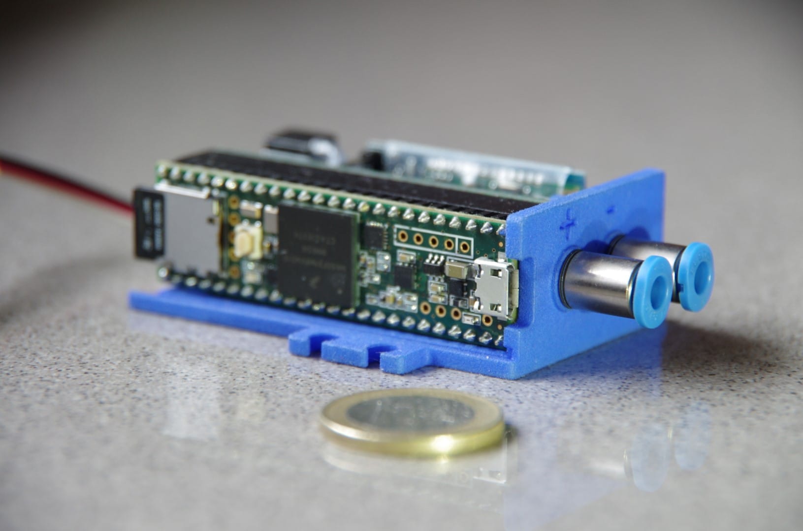
The Pi2 streams video, telemetry via mavproxy, talks to the PS2 controller directly over bluetooth or via wifi to the groundstation, and streams controller inputs to the Arduino Teensy via I2C.

The Arduino handles all the real time stuff, it generates an SBus signal for the PixFalcon and will (eventually) sample sonar sensors.

Everything else is pretty standard. The camera gimbal is vibration damped with foam ear plugs, the PixFalcon as well by clamping it between foam pads and the front booms fold back for transport.

Here are some more photos :-

3689723203?profile=original

3689723252?profile=original

3689723200?profile=original

Read more…

3689723172?profile=original

We are glad to release the latest firmware update to Precis OEM boards, the 1.15 version. Firmware V1.15 provides users with more robust RTK fix solution and accuracy. It provides other improved performance such as RTK solution of long baseline. Some known issues have been fixed as well. All update improves RTK positioning performance and high-precision navigation in more challenging environments.

Useful links

Firmware download

www.tersus-gnss.com/pages/software

User guide

www.tersus-gnss.com/pages/documents

Read more…

Condition surveying with UAVs and Sputnik GIS

Spuntik GIS is widely used in condition surveying. Hi-definition 3D-models of buildings and constructions allows specialist to detect defects and deformations, more than, it is available to vectorize and save such areas using *.kml editor.  Therefore, the result of inspection is 3D-map of defects and deformations.

3689723892?profile=original

One of the leading project in this area for Geoscan is – condition survey of smokestacks. In this project, we use not only regular 3D-models of pipes with photorealistic textures but also 3D-models with thermal imagery textures.  This approach allows solving problems of pipe inspection very accuracy.

3689724110?profile=original

To make the process of inspection of high altitude objects easy, in Sputnik 1.3 we developed special navigation mode. Now the user can move along the wall of the structure along the vertical axis using first person camera mode or using combination of CTRL key and mouse wheel. To simplify the process of using aerial photos in object inspection, we released the feature of photo selection. Now you can select photos of point of your interest with just two clicks.

3689724155?profile=original

As additional option for this project, we released the feature of viewing DXF with raster underlay. Therefore, viewing of drawing of tube synchronized with its TLS model.

Try Sputnik GIS for your condition survey projects.

Trial version of Sputnik GIS 1.3 is available via this link: https://www.geoscan.aero/en/sputnik/

Read more about Sputnik GIS 1.3 in our blog: https://www.geoscan.aero/en/blog/

Read more…

Last time i introduced DroneePlotter which is completely free  in browser flight log analiser tool for Ardupilot and PX4 log files.

After many feebdacks we have added many features to DroneePlotter .

1.we added lz4 compression support for upload and download of the files.Lz4 compresses binary files around 50%, Which means you get x2 more upload/download speed. Binary files are served with 1year cached flag which means if you open multiple instances of the same url, the data files will be served from browser cache after the first download

2.mavgraph.xml support you can click enable or drag and drop xml file which will be stored in browser cache.

3.FFT graph of ISBH frames for vibration measurement

5.GPS randomisign.Before uploading the binary file now you can randomize gps trajectory origin. Which will take the flight start to a random gps coordinate on the Earth.

Your feedbcaks, reviews are very wellcome.

Read more…

DIY Air Data Computer Asgard

IMGP5583.jpg?width=750

The air data computer Asgard is out. It is a unit designed for DIYers, size and weight are compatible (fixation tabs have the same dimensions of standards servo tabs) with low-cost RC applications.  Some aspects will be changed as per users feedback. Be sure to checkout the project website for detailed information on how you can build your own.

Read more…

So we were testing certain stuff in our lab yesterday, and I thought, why don't we share our approach? That would be such a great way to show off the capabilities of the UAVCAN GUI Tool. Check this out:

The video features the following products and instruments:

  • UAVCAN GUI Tool version 0.9
  • Zubax Babel (USB-CAN adapter)
  • Zubax Orel 20 (the ESC)
  • Tarot MT4008 motor with Tarot 1555 high strength plastic propeller
  • MASTECH HY5030 DC power supply
  • RCbenchmark 1520 testing rig (optional)

The motor is controlled by the UAVCAN GUI Tool by virtue of this simple snippet in Python that runs in the interactive console: https://gist.github.com/pavel-kirienko/d4a59581af26aa359bc86d5d7ed6d3e0. The X-Y plotting feature of the UAVCAN GUI Tool allows us to directly plot the relationship between the electrical power and the mechanical RPM of the propeller. The UAVCAN GUI tool is a powerful one-size-fits-all instrument that can be used to easily analyze and demonstrate the behavior of various UAVCAN-enabled systems.

This post is actually a repost from our blog. The blog is so new and shiny, people hardly ever read it. But if you find this relevant, you probably should either register here or subscribe to the RSS, or something.

Read more…

Hey Everyone, we are creating this tutorial series to help you connect your drones to Cloud. (You can use your existing setup with a CC and 4G/LTE dongle)

FlytBase Cloud helps you connect your drones to the cloud. Set UAV missions, get telemetry and payload drone data remotely over the Internet. 
This video helps to set up a virtual drone. It provides one-click access to cloud simulator instance for drone developers. You can test applications in a safe and secure environment, resolve issues and accelerate your development process.

You can signup and request beta access at my.flytbase.com/cloud

Support us by hitting subscribe on our Youtube Channel 
https://youtu.be/lNCA13mgbdw

Let us know your thoughts in comments. Thanks.

--

If you are developing applications for delivery, public safety, construction, inspection, docking station etc.? We can help you, write to us at letstalk@flytbase.com

Read more…


3689723120?profile=originalAero-Hawk  announces the arrival of Field Hawk. A new to the market Unmanned Aerial Vehicle. With the Field Hawk Farmers get a drone capable of providing useful information using Wavelength Specific Filters to Notice Chlorophyll Health, Cell Structure, and Water content. The Field Hawk was designed in house out of tough nylon, using high quality parts. Rising to the challenge of gathering usable plant information at a low cost. The Field Hawk can come equipped with either a 2 or 4 Camera array capable of 60 to 120 gigabytes of information storage. These cameras paired with the powerful yet simple AeroHawk Maps application gives the farmer an edge in efficiency in today’s competitive market. The advanced Flight Controller Pixhawk 2 Cube is operating this aircraft that is capable of fully autonomous missions with a flip of a switch. With a simple 2-axis gimbal the M series cameras get a clear  8 Megapixel image every time the shutter is triggered  Aero-Hawk has developed a full package of Hardware, Software, and Online Support so the farmer can not only just see the data but also use it In his everyday operation. Go check it out at https://aero-hawk.com/ 

On a similar note we are also a distributor for the Pixhawk 2 in the North West of the US. 

Thank you!

Read more…

70944314?profile=RESIZE_1024x1024

One year has passed since I launched the autonomous boat OpenTransat that has attempted to cross the Atlantic Ocean and I wrote an article about it. The boat is lost in the ocean after being hit by crazy storms, but I didn't give up. Currently, I am working on the next sailboat with improved hardware and software and a more robust construction. The above picture is the design which is not final yet – it will be further improved in several aspects.

You see, it's based on interesting concept – a rigid wingsail that's adjusted by a "flap". It works much like an airplane wing. It's not something new – it has been used even on manned yachts:

3689723058?profile=originalHowever, I had no experience with this thing and I wasn't confident enough to believe it can work. Before going to spend a lot of time building a new 2-meter boat that will be designed for extreme ocean conditions, I've decided to build a 65-cm model to test and tweak the concept. Along the path, I've learned skills necessary to build strong composite parts.

3689723014?profile=originalThe carbon fiber/Kevlar hull is filled with a closed-cell polyurethane foam and painted with a special antifouling paint. This kind of paint doesn't give as smooth finish as a gelcoat or normal paint, but it prevents subaquatic organisms from attaching to the hull.

3689722974?profile=originalA waterproof servo is used for steering. As this is just a model for lake testing, the IP67 rating is acceptable here.

3689723023?profile=originalThe boat uses the same custom hardware and navigation software as the final design. The hardware is optimized for low power consumption and it includes plenty of sensors to provide more insight of what's happening with the boat. The program can be uploaded over Wifi which makes life a lot easier – I can debug and overwrite the program from the shore or motorboat. The battery provides enough power for 8 hours of continuous operation.

3689722995?profile=originalThe wingsail is made from a foam wrapped with carbon fiber.

And here's the finished boat:

3689723075?profile=originalCheck out the video of the boat sailing on a lake:

I'm happy to see it works!

You can follow the progress on this facebook page where I share all the details, attempts, mistakes and solutions:
https://www.facebook.com/OpenTransat/

Read more…

2 years ago we decided to make a professional mapping &surveying drone and not just for surveyors also with easy API's to help developers/researchers to develop drone applications quickly. And we took 4 main priorities on DroneePLANE:

1.Super easy to operate

2.Safe

3.Easy to carry 

4.Affordable

With these main priorities after 2 years DroneePLANE was born. The Professional Mapping and Surveying Drone.

3689724201?profile=original


TECHNICAL SPECIFICATIONS

Weight -----------------------------------------. 0.6 kg 
Payload capacity------------------------------0.18kg
Wingspan --------------------------------------100cm 
  Material ---------------EPP foam,carbon structure 
  Propulsion -----------------Electric brushless motor
 Battery -----------------------------10.8 V, 3500 mAh
 Carry case dimensions ----------65 x 50 x 30 cm 

SOFTWARE 

Flight planning & control software --------- DroneeCockpit

(Ground Control App currently works on Ipad)

FLIGHT CHARACTERISTICS

Maximum flight time---------------------------up to 60min

Optimal Cruise speed-------------------------------12 m/s

Radio link range----------------------------------Up to 5km

Wind resistance--------------------------------up to 12m/s

CAMERA

Dronee supports Sony/GoPro with wifi and all gphoto2 triggering supported cameras including Parrot Seqoioa.

Dronee COCKPIT

Ground Control Software

We designed DroneeCockpit from ground up to empower non-pilots to simulate challenging realistic flight missions through its sophisticated design, and no prior flying experience is required!  You can download  Dronee COCKPIT from App Store and try by yourself.

3689724251?profile=original

DroneeCockpit has many advanced features like:

Multi Flight feature: you can scan even larger area with multiple flights.If the battery finishes during the scan.Dronee lands and memorizes where it left in the next flight.


Optimized Flight Plath: For windy weather DroneeCockpit Flight Management Software has “Route Optimisation”  algorithm, it  rearranges waypoint orders to give less drift in windy conditions without changing the result of the process.

3689724265?profile=original

DRONEE  API for Developers

Last but not least, DroneePlane is developer friendly. It has built-in companion computer  (RaspberryPi CM3)  with running  Linux operating system and also it has on board GPIO. DroneePlane comes with easy API's to help developers/researchers to develop drone applications airbornready quickly.

For more information check our website : https://dron.ee/pages/droneeplane

You can also contact us for special customization.

Cheers

Read more…

Sputnik GIS 1.3 by Geoscan has been released!

3689724001?profile=original

Hello everyone!

                In Geoscan we develop multidimensional spatial data visualization system – Sputnik GIS. It is a great tool for viewing and analyzing wide range of UAV survey results.

                Today we are glad to present you a new version of Sputnik 1.3. In this version, we improved TLS rendering algorithm and released new features.  Please check out the list of improvements and innovations below.

  1. TLS rendering – the speed of rendering along with detail level increased, high FPS is maintained. The chance of coarse objects (LOD) appearing during model rotation is reduced.
  2. Close to wall navigation is improved – we added first person camera mode and keys combination to move along vertical axis of object
  3. Export part of TLS model – we added tool to export interested part of TLS model to OBJ, 3DS and DAE. For DAE and 3DS formats, backward compatibility with Sputnik is implemented
  4. WMTS support -  along with support of WMS services, Sputnik 1.3 supports WMTS services. Thanks to this innovation, you can use the maps you created on the Mapbox service. Also you can use GetFeatureInfo function.
  5. OC3 and LAS support – now it is available to view OC3 (Photoscan point cloud format) and LAS ( Lidar)
  6. Color palettes – from new version it is available to style raster maps in *.geotiff format
  7. Photo selection – new feature of photo selection for specified point makes Sputnik a great tool for analyzing condition survey results.

Try out new features of Sputnik GIS!

You can download trial version of Sputnik 1.3 using this link - https://www.geoscan.aero/en/sputnik/

Read more…

UgCS 2.12 Has Been Released

3689722947?profile=original

Hi, guys,

We are glad to announce that a new version of UgCS is out - 2.12. Along with this update we are also releasing UgCS Mapper in beta version. UgCS Mapper is a geo-referenced image processing software that allows creation of preliminary orthophoto maps in-field, requiring no internet connection.

3689722836?profile=original

The double grid option is added for Area scan and Photogrammetry tool, to enable more precise aerial data acquiring. When a new Photogrammetry area is being added to the survey mission, by default the action Camera by time (with auto flag) is added.

For more comfortable mission planning features like the option to move and rotate route, manage common actions for selected segments and displaying of calculated path leg length on cursor-hover, polygon side length and calculated area size is displayed.

While in beta UgCS Mapper is available for all users, but after its  official release it will be a part of UgCS PRO and UgCS ENTERPRISE package.

For you Ardupilot users out there we have added SET_SERVO and REPEAT_SERVO commands, allowing you to use auxiliary devices capable of receiving PWM signals and controlling them directly from UgCS. We have also added the option to connect over UDP as well as the ability to set constant heading (disable yaw to next waypoint).


Download latest UgCS version: www.ugcs.com/download

Safe flights,
UgCS Team

Read more…

What are the 5 Top Beginner Drone Kits You Can Buy in 2017 to Learn and Build Your Drone

The prices of drones have fallen recently and building a drone from a drone kit may not save you money but it is still a fun and a learning activity. When you build your drone from scratch, you know what goes where and it helps if something gets broken. You can quickly buy the replacement and fix it. Drone kits are therefore still popular for amongst many drone enthusiasts. In this article I have tried to list five top drone kits in the market you can buy and build your drone.

1. F450 ARF Drone KIT from DJI

This is a starter drone kit. Good frame design with sufficient space to mount the accessories. The frame is available in three different colors. The accessories you have to buy separately are the radio controller, gimbal and camera and the batteries. There are helping tutorial videos available which will assist you in building your DIY drone.

3689722814?profile=original

2. LHI250 Quadcopter Kit

 This is a mini quadcopter kit with a frame size of 250 mm. The kit is unassembled. You may also purchase an assembled version which is a bit more expensive but you can still learn from it more easily if you are just a beginner. You will have to buy the radio transmitter separately. The prices are very reasonable. Four LHI MT2204 2300KV Motors comes with the kit with LHI 12A Brushless SimonK ECSs.  OpenPilot CC3D is the flight controller. The best part is that you can use opensource OpenPilot software on your tablet.

3689722903?profile=original

3. 3D IRIS+ Quadcopter Kit by 3DR

This is the best kit for beginners. The kit include all the required components and you just need to put them together. However, the gimbal is not in the kit. You can buy this as an add-on. Tarot is the recommended gimbal for this kit. The kit include the radio controller, , props, landing gear, telemetry module, cables and battery with battery charger. The telemetry antenna is attached and the frame is pre-assembled. You should order the proper (American or European) telemetry radio set when ordering the kit.  The flight controller is Pixhawk.

3689722924?profile=original

4. QAV250 Carbon Fiber Mini FPV Quadcopter Kit

This is a drone kit by Lumenier. QAV250 is a popular mini FPV quadcopter kit. The frame size is 250mm.  This G10 version is a carbon fiber version. It can accommodate 5" Props. For bigger 6” props, you need to buy QAV250 6" Carbon Fiber Arm Extensions.

 You can also buy QAV250 frame-only and then can add other components of your choice. You can also buy this drone on Amazon and getfpv websites. A good kit for beginners, it can save you time, and you can still play around and learn. The 250mm is the distance measured motor shaft to motor shaft diagonally. If you go for a frame-only option, the compatible motors would be light and sturdy Lumenier RX2206 2350kv motors.  You can also use GoPro camera instead of a Lumenier camera, you would need a QAV250 CF Vibration Damping Camera Plate. This will reduce the vibration by separating the camera plate from the air-frame and by absorbing vibration. 

3689722888?profile=original

5. GB 190, Racing Drone kit by Gearbest

It is a full quadcopter kit. You just have to add a radio receiver which should be compatible with your radio transmitter. The kit has two versions, standard and racing. Here we discuss the racing version. The kit comes with an X frame, PDB, F3 flight controller, EMAX RS2205 motors (brushless), camera, props, ESCs, connectors, VTX and antenna and few other accessories. The price is very affordable. The camera is also included. The kit is very compact. Frame arms are mad of carbon fiber with one small structural component made of aluminum.

3689722831?profile=original

Want to Buy a Drone:

If you are interested in buying a drone, you may find the following articles useful on Personal Drones:

1. 4 Best Beginner Drones

2. 5 Affordable Drones with Camera

Read more…

3689722801?profile=original

I believe three of the biggest misconceptions in the drone industry is how fast it will grow, which sectors will grow, and which ones will lag.

No one disagrees that drones—both consumer and professional—represent a new and emerging market. Drone market forecasts abound. We currently track 73 independent companies that provide market forecasts, and each of them projects growth for the drone or unmanned aerial system (UAS) sector that is nothing short of phenomenal. Some of these, however, are questionable, because, at the time they were written, there were no historical sales or reliable market survey data on which to create a proper forecast. We wrote about this problem back in 2015 here. Still, today we still see a big gap between current forecasts and actual purchases, services, and business adoption.

In this article, I’m going to take a look at some of the data collected in our latest report on the drone industry—data we think is important to you and answers the question: “Why don’t we see widespread adoption of drones in my industry just yet?”

Business use defined

As part of our 2017 Drone Market Sector Report, we conducted a survey to identify the business users for drone-based projects and which industries have traction. We define “business users” as those individuals or companies that use or purchase drone-based imaging or sensing services. A total of 623 respondents answered our qualifying survey question that they either do such work themselves or contract out for it.

When we asked respondents about the primary commercial drone-based service they perform or purchase, the results show that:

  • the #1 business use is aerial photography and/or video at 31%,
  • the #2 use is surveying / mapping / GIS with 20%,
  • and the #3 use is construction (design, building inspection, or monitoring) at 6%.

Company size

To gauge the extent of drone use, we asked our business users about their company’s revenue, the number of projects they perform per month, and the number of remote pilots they employ. As with service providers, the numbers are low. For example, 75% of business users perform one to five projects per month.

The revenue figures of business users reveal an interesting trend as well. More than half (53%) are small and medium-size businesses (SMBs)—organizations with less than $10 million in annual revenue. Only 6% could be classified as a large enterprise, i.e., an organization that makes over $1 billion.

As we did with drone-based service providers, we asked these business users how many aviation-authority, licensed small UAS / UAV remote pilots they currently employ. The numbers were smaller than we expected. Almost three-quarters (74%) have five or fewer pilots; 50% have only one.

Certainly these numbers debunk the media hype about drones. There are not hundreds of thousands of drones flying now (certainly not at the same time), nor is it true that Millions More Drones Will Be Flying Above Your Head by 2020 and in this piece we make the case Why the Drone Network of Tomorrow is Farther Away Than You Think.

Limited success stories on integration

Our research finds widespread business adoption is being hampered by a reluctance to share too much information about successes.

Companies are depending on information communicated about drones by others that have been successful. Certainly the interest is there. You can see that from the diversity of industries attending the major U.S. commercial drone expos, such as InterDrone, Commercial UAV Expo, and Drone World Expo (which was just purchased by Commercial UAV Expo). Unfortunately, only a handful of companies (we estimate 75–100) are willing to come forward and present their use cases at these shows. Most of these presentations are not about companywide adoption, but rather about a particular, localized proof of concept.

There are positive messages in which the benefits of drones are explained, but communication about what a successful integration looks like is still very limited. Additionally, we find that companies that are already using drones are reluctant to share too much information, so they can continue to reap the benefits of their early investments. As a result of this reluctance to share information, further integration lags as companies wait on successful user stories that may never appear.

Bottom line

Unfortunately, the media all too often equates the business use of drones with drone delivery, and only reports on the headline-seeking efforts of Amazon, Google, and Facebook. There is so much more that’s actually happening, and it’s getting difficult to generate a comprehensive story on business use. Some of this can be attributed to the fact that many of the major industrial users are starting to focus only on the use cases that matter to them. The most concrete examples of this are the NAB Show, which brings together photography, video, and cinema professionals; the Energy Drone Coalition Summit, which is bringing together the major drone / UAV ecosystem players with the energy industry asset owners and end users; the American Society for Photogrammetry and Remote Sensing (ASPRS), which hosted a pre-conference UAS Technical Symposium this year at the Commercial UAV Expo, and will co-locate with the International LiDAR Mapping Forum in 2018.

That said, we will continue to do research on individual verticals and report growth and adoption issues.

If you have questions about what's in the report or would like to comment on it after reading it, write me at colin@droneanalyst.com.


Image credit: Shutterstock
Read more…

Skywalker X8 Tiltrotor (VTOL) Aircraft

Hi everyone,

I want to share my latest project, Skywalker X8 Tiltrotor. It uses Arduplane 3.8.2 firmware. Tilting mechanism and integration parts were printed with  a 3D printer. I made some transition tests a few weeks ago.

I made its maiden flight one year ago.

My current configuration:

Frame Kit: Skywalker X8
Vtol Conversion Parts: Custom 3D printed
Motor: Rctimer x5(400kV), 4 pieces
Speed Controller: Hobbywing 40A
Propellers: 17x5.5
Battery: Gens Ace 6s5100x2
BEC: Hobbywing 10A (Max 20A)
Flight Controller: Pixhawk,GPS recevier, Airspeed sensor
Tilt Servos: Savox SC-0251MG, 4 pieces
Wing (Elevon) Servos: Turnigy TGY-S712G, 2 pieces
Takeoff Weight: Approx. 5kg

As a result, I made a third flight last week and I had a crash (Youtube video is on the way) After I check the log files and my configuration I will repair my plane and continue flights to perform full forward flight transition. 

You can check my blog at www.ersingonul.com for project details.


Read more…

We are running an auction on our first batch's hardware and I thought it was something diydrones would be interested in. Our first batch is 1240-1300 MHz, with included HDMI/camera inputs.

with_camera.png

Bonafidepirate flew it to around 14 kilometres using a 8 dBi patch antenna:

We are loosing money already on this batch and will probably need to accept bank wire transfers only for the second batch, while we are accepting credit cards via Stripe for this first one.

Feel free to ask me anything in the comments!

https://fpv.blue/

Read more…
MR60

Make your own Li-Ion battery pack

Hi guys,

Did you know you could build your own Li-Ion battery pack ?

Li-Ion batteries have the highest energy density per unit of mass available to us.

In comparison with LiPo batteries, you get 30% less weight for the same mAh capacity, which translates into direct endurance or increased flight autonomy.

Ready made LiIon batteries for dorne users are not mainstream (they are not sold on hobbyking, nor any other main RC online shops), and are quite expensive.

A DIY assembled pack is a fun project and will get you a much cheaper LiIon battery made to your custom requirements.

You can select individual cells based on their total capacity, based on how many amps they can continuously discharge.

You can then add them up in series to get the tight S voltage, and add them up in parallel to get the right minimum amps continuous discharge rate.

In the video I show how I've built a 4S battery which is able to output 30 amps continuously, with a 10 500 mAh capacity. It will be used on my 300 class folding quadcopter for an endurance test.

cheers,

Hugues

Read more…